周麟 , 沈体雁
, 沈体雁
北京大学政府管理学院,北京 100871
ZHOU Lin, SHEN Tiyan
版权声明: 2016 地理科学进展 《地理科学进展》杂志 版权所有
基金资助:
作者简介:
作者简介:周麟(1988-),男,河北保定人,博士研究生,主要从事城市空间结构、服务业区位研究,E-mail: zhoulinup@pku.edu.cn。
展开
摘要
随着服务经济全球化时代的到来,服务业正在成为不同大洲和国家大城市发展的核心动力,而不同规模、类型服务业的区位选择也被视为塑造大城市内部经济结构的主要驱动因子。基于此,本文从空间分布格局、区位选择偏好、主要影响因素等3个方面对国外大城市内部服务业区位的研究进展进行综述。主要结论包含:①集聚与扩散的解读是区位研究的核心。②交通要素在集聚与扩散过程中扮演着重要角色。③研究视角趋向微观化。④强调地方政策、人居环境等非经济要素对于服务业的影响。⑤开始关注社会公平。最后,本文针对中国大城市内部服务业区位研究与实践提出:应加强基于企业个体数据的演化规律探讨,推动地理空间分析的社会经济转向以及有机嵌入城市规划与管理体系。
关键词:
Abstract
With the globalization of services economy, services are becoming the core driving forces of metropolis development in different countries. Location choice of services is also the main factor that shapes the economic structure in metropolis. Therefore, this article examines progress of services location research in metropolis from three aspects: spatial pattern, location preference, and main influence factors. The main findings are as follows: (1) Discussion of services agglomeration and diffusion is often the most important topic. (2) Transportation factor is of high importance in the process of services agglomeration and diffusion. (3) The research perspective tends to be microscopic. (4) The influence of noneconomic factors such as urban amenity and local policy are being taken seriously. (5) Some researchers have focused on social equity and worked on the differentiation of services between different social groups. Finally, this article recommends further research on change analysis based on data of individual service companies, refocusing geospatial research on socioeconomic issues, and embedding services research into urban planning and management system.
Keywords:
20世纪60年代以来,随着工业企业服务外包的兴起、社会福利制度的构建以及信息技术革命等一系列创新机制,西方发达国家的服务经济迅速发展(Jansson, 2013)。世界银行统计数据表明,各国服务业增加值占GDP比重的均值,自2009年起便稳定在70%以上,远超60%的服务经济标准线,标志着服务经济全球化时代已经到来。考虑到城市空间结构作为社会经济要素的地理投影(陆大道, 1995),服务业的区位选择已成为城市发展的重要驱动力,不仅长期影响职住平衡、土地资源配置等实际问题,同时也是地理学、城乡规划学、区域经济学等学科的重要议题。相比而言,中国经济结构正处于转型关键期,2015年服务业增加值占GDP比重达50.5%,虽然距世界平均水平仍有差距,但无论是增加值还是占GDP比重均连续3年超过工业,可以预见,服务业正在成为新常态下中国经济发展的强大引擎,也将直接影响城市功能与结构的和谐共生(申玉铭等, 2015)。在此基础上,本文置身于世界坐标系,对国外文献中的服务业区位研究进行述评,并基于文献检索与分析提出"空间分布格局—区位选择偏好—主要影响因素"的综述框架,为国内学者研究提供借鉴,也为中国服务经济发展能力的提升以及城市空间结构的存量优化提供启示。
服务业包罗万象、错综复杂,区位研究的差异性十分明显。因此,本文提出如下两点限定:①选取重点研究的服务业类型。综合考虑篇幅限制与服务对象、性质及评价标准,本文主要将以获取经济利益为目的,自主从事经济活动的行业视为综述对象,未包含教育、卫生和社会工作等以提供公共服务为主的社会性服务机构,并参考国外普遍接受的辛格曼服务业四分法与国内《服务业发展"十二五"规划》、《城乡规划用地分类标准》等对服务业类型的界定,将2011年版《国民经济行业分类》中的8类行业划入研究范围,分为生产性、生活性服务业进行综述。信息传输、软件和信息技术服务业(I类),金融业(J类),房地产业(K类),租赁和商务服务业(L类),科学研究和技术服务业(M类)等提供中间产品或服务的行业作为生产性服务业;批发和零售业(F类),住宿和餐饮业(H类),居民服务、修理和其他服务业(O类)等直接向居民提供消费品或服务的行业则纳入生活性服务业范畴。②综述将聚焦于大城市内部。随着服务经济时代的来临,不同大洲和国家的大城市均出现从物质产品生产中心向科技、文化与服务中心转变的趋势,产业结构趋向软性化(石忆邵等, 2012)。同时,服务业所特有的产品无形性、个人消费性等属性决定了城市内部是其天然的滋生地(申玉铭等, 2009)。可以说,服务经济已成为大城市内部共同的经济形态与发展引擎,有必要对其区位研究进行系统综述。
空间分布格局的相关文献旨在客观地描述大城市内部的服务业受空间相互作用而形成的位置状态与布局规律,主要议题集中在以下两方面:一是郊区化进程中的空间集聚与扩散模式。随着郊区化现象的越发普遍,服务经济活动的空间分布格局受到广泛关注,多中心、单中心还是分散化的集聚与扩散模式成为学者长期探讨的内容。二是交通基础设施引导下的空间经济现象。机场、轨道交通站点等基础设施的投资建设是地方经济增长的重要推力,不仅可改变经济要素的流向,也在诸多大城市诱发了服务业的迁移与集聚,这种空间经济现象吸引了众多学者从事研究。
2.1.1 生产性服务业
郊区化动力机制的不同导致生产性服务业的空间分布格局呈现地域性差异。其中,欧美学界的研究展现了多中心模式的普遍性与差异性,并详细描述了CBD、次中心与有序蔓延之间的互动联系(Coffey et al, 2002; Hermelin, 2007; Sokol et al, 2008)。Boiteux-Orain等(2004)、Arauzo-Carod(2015)认为,1978-2011年间巴黎的生产性服务业布局呈现典型的多中心模式,CBD始终是经济活动的核心区域,多个郊区次中心的集聚程度则不断增强,且出现业态专门化趋势。Leslie等对菲尼克斯的研究也得到类似结论,并认为多中心模式的形成源于大型企业在CBD的持续集聚和不同类型企业差异化的有序蔓延机制(Leslie et al, 2006; Leslie, 2010)。Drennan等(2011)指出,美国49个大城市均存在多中心模式,并进一步将其按照生产性服务业的发展水平分为4个层级,仅第一层级城市的CBD没有发生规模经济的扩散,其他城市的CBD虽然具备首位优势,但发展速度均滞后于主要次中心。与此同时,受到人口郊区化与新城新区建设等影响,亚洲大城市的多中心模式也趋向常态,但出现两种截然不同的发展机制:北京、上海、东京的生产性服务业均在CBD和次中心持续集聚,且主次中心呈现分工协作特征(Sassen, 2001; Han et al, 2009; Pan et al, 2015),而在对首尔、广州的研究中,康南(Kangnan)新城与珠江新城作为政府主导的新城,发展初期便迅速崛起,大量企业的持续进驻使其在近年来逐渐取代原本的CBD,这种CBD的漂移彰显了政策引导在亚洲城市的重要性(Yi et al, 2011; Kim et al, 2014)。
与上述研究结论不同,大洋洲与拉丁美洲大城市的生产性服务业布局以单中心模式为主。Watkins(2009)指出,1971-2006年间墨尔本的生产性服务业高度集聚在CBD,且出现业态专门化特征;与巴黎、东京等城市不同,郊区企业总体呈现分散分布的布局模式,并未形成次中心,悉尼、布里斯班等城市也存在类似现象(Freestone et al, 1998; Trendle, 2003)。拉丁美洲的城市蔓延主要源于新移民迁入及保障性住房的郊区化政策,因而较难形成成熟的多中心模式(Suá;rez et al, 2009)。例如,Suá;rez等(2009)指出,墨西哥城的生产性服务业主要集中在CBD,并出现沿交通干道向外线性扩散的趋势。Ferná;ndez-Maldonado等(2014)基于就业密度与企业密度双重门槛,认为墨西哥城、利马以及福塔莱萨等大城市已具备多中心分布的雏形,但潜在次中心受到通勤成本与功能分区的影响,均毗邻CBD出现,因而仍可视为单中心模式,只是中心范围在不断扩大。
2.1.2 生活性服务业
与生产性服务业不同,生活性服务业的郊区化、分散化已成为学界共识。Robertson(1983)、Wassmer(2002)认为,1954-1997年间,随着CBD的营业额大幅下降,美国主要城市的零售业均出现向郊区扩散的特征。Lee等(2006)进一步对1980-1990年间12个大城市的批发零售业进行分析,除休斯顿以外,其他城市郊区的从业人员比重均超过60%,部分城市甚至达到80%,且年均增幅均非常显著。个案研究中,Dong(2013)以波特兰为案例指出,虽然规划、政策积极推动着中心城区的城市更新,但零售业、餐饮业等仍快速向郊区蔓延,并出现分散化集聚特征。卡迪夫、乌得勒支、首尔、上海等欧亚城市也存在类似现象(Wang et al, 2005; Weltevreden et al, 2005; Guy, 2010; Kim et al, 2014)。此外,郊区购物中心、大卖场等商业综合体在20世纪90年代的兴起,对于生活性服务业的空间分布格局构建具有显著影响。Jones等(2000)、Walmsley(2006)基于多伦多与悉尼的分析指出,商业综合体的建成能大幅提升所在区域的商业氛围,并引发餐饮、零售机构在其周边迅速集聚。Teller(2008)则认为,传统商业街的衰落和郊区商业综合体的兴起在欧洲主要城市同步发生,由此形成以商业活动为核心的再郊区化。
重大交通基础设施的集聚溢出效应明显。首先,对机场引导下的空间经济现象进行综述。随着全球化、网络化的到来,集办公、娱乐与生活为一体的机场经济体正逐渐形成(Breure et al, 2003; McNeill, 2009)。Kasarda等(2011)认为,机场周边正在形成新的集聚经济区域,不同类型企业的进驻使这种经济体呈现运营独立性、业态多元化特征。Appold等(2013)、Cidell(2015)则指出,美国25个主要机场经济体在1996-2009年间的就业密度增速明显高于城市内部的大多数区域,特别是在1996-2002年间达到CBD的2倍,其中4个经济体已取代对应城市CBD的位置,5个则成为仅次于CBD的经济活动中心。其次,轨道交通建设作为中国当前的社会热点,在国外学界同样受到关注。如Hensher等(2012)对悉尼串联中心城区与郊区的轨道交通沿线进行分析,结果表明生产性服务业的就业密度在站点周边持续增高。Meijia-Dorantes等(2012)在马德里的研究中指出,近郊新地铁线路诱发了不同类型企业的集聚,并将其定义为马德里地铁的规模经济现象。Beyazit(2015)则认为,伊斯坦布尔地铁的建设推动了地铁沿线的工业用地置换,众多生产性、生活性服务业迁移至此。
区位选择偏好研究多从微观博弈视角出发,对服务业企业在大城市内部的选址规律进行总结,具体包含以下两部分内容:一是区位选择的集聚区域偏好。追求利益最大化、自身满意化的共同目的促使不同规模、类型的服务业偏好分布区域各异,这一现象吸引了众多学者的目光。二是区位选择的交通网络偏好。交通网络作为经济活动的空间载体与流通廊道,对城市的合理运转起到支配作用。随着复杂科学引入城市与区域研究领域,一些学者开始探讨交通网络的分形特征,并对服务业区位选择的交通网络偏好开展研究。
3.1.1 生产性服务业
生产性服务业的研究中,国外文献大多认为企业层级对其区位选择偏好起到决定性作用。Shearmur等(2002)将巴黎的金融业企业分为3类:总部经济型企业高度集聚在CBD,分支机构倾向分布在CBD及次中心,便民型机构则出现分散化分布的特征。Leslie(2007)对菲尼克斯的研究发现,不同类型企业的集聚程度差别较大,会计、律所、金融业与信息技术这4类行业的集聚程度最高,其中大型企业偏好在CBD集聚,以享有规模经济;而中小型企业则偏好分布在郊区,以满足居民日常需求。Watkins(2014)发现墨尔本也存在类似现象,高层级企业更加偏好分布在CBD及周边,而相关分支机构则呈现分散化、郊区化特征。
作为知识高度集中与扩散的显性载体,信息技术、科学研究等高新技术行业的区位选择偏好成为研究重点,然而结果却大相径庭。米兰、巴黎、多伦多、温哥华等城市的高新技术行业企业偏好分布在郊区及卫星城,由此带动了高精尖、专门化次中心的形成(Airoldi et al, 1997; Shearmur et al, 2007; Halbert, 2012);而Storper等(2006)、Birch(2009)、Mé;ndez等(2011)则指出,这类企业仍偏好分布在CBD及邻近次中心,它们所创造的知识创新环境也是重塑城市中心区活力的关键。同时,部分学者认为上述两种现象同时存在。例如:Muñiz等(2010)、Shearmur(2012)指出,巴塞罗那与蒙特利尔的高新技术企业不仅高度集聚在郊区的科技城,在传统CBD的企业密度也要高于其他行业。Wei等(2015)则对上海市软件行业进行分析,认为外资企业具有显著的中心城区偏好特征,而内资企业则出现向外扩散机制且偏好郊区科技园集聚。
3.1.2 生活性服务业
生活性服务业研究中,诸多学者发现即便是某一特定行业,其内部企业由于服务水平、针对人群等要素的差异也表现出截然不同的集聚区域偏好。Prayag等(2012)指出,新西兰汉密尔顿的新增餐饮业由偏好CBD集聚逐渐向偏好郊区集聚转变,其中泰式、印度式餐馆毗邻移民社区分布,郊区化特征显著。Rogerson(2012)以南非开普敦、德班及伊丽莎白港的酒店行业为研究对象,发现除一星级酒店趋于分散分布外,其他星级酒店均偏好分布在滨海旅游区与CBD。Wang等(2014)则对长春市零售业进行分析,认为专卖店与零售商店倾向集聚分布以获取居民的一站式购物需求,超市、商业综合体及家具城则倾向分散分布以避免竞争,其中商业综合体与专卖店更偏好毗邻CBD分布。
与此同时,"食物沙漠"(食物沙漠:缺乏健康、新鲜食物供应的社区(Shaw, 2006; Walker et al, 2010),也有学者按照数量指标将其定义为:拥有少于10个商店且核心商店从业人员不超过20人的社区(Hendrickson et al, 2006)。)现象在2000年之后受到学界重视,相关研究主要聚焦在超市、杂货店、快餐店等机构的区位偏好分异。Block等2004和Block等(2006)对新奥尔良、芝加哥的研究表明,黑人社区的超市数量明显少于白人社区,然而快餐店数量却是白人社区的6倍。Kwate等(2009)以纽约为案例地,同样认为快餐店的区位选择具有明显的黑人社区偏好,并指出这与社区的整体收入水平并不相关。Choi等(2013)则指出,东京的"食物沙漠"倾向在老年人、失业者及无车家庭等低收入人群集聚的区域出现。这种经济活动的区位偏好分异在一定程度上影响了超重、肥胖等健康问题的产生,也加剧了城市内部的社会分异。
交通网络偏好的相关文献论证了良好的通达能力对于企业区位选择的重要性,且主要集中在生活性服务业领域。首先,诸多学者基于空间句法视角,对交通网络偏好进行了大量实证研究。Hillier等以伦敦国王十字街与金融城为例,指出零售业更偏好在可达性(可达性:特定街巷距离其他所有街巷的远近程度。)高的街巷两侧分布,并认为具有显著空间优势的街巷承载了大多数经济活动(Hillier, 1996; Hillier et al, 1993; Hillier et al, 2012)。van Nes(2005)、Scoppa等(2015)通过对阿姆斯特丹、布宜诺斯艾利斯的研究证实,商业活动显著集聚在连接性(连接性:特定街巷直接连接街巷的数量。)高的街巷两侧。Chiaradia等(2012)则指出伦敦主要商业中心所在街巷的可达性与通勤性(通勤性:特定街巷被其他任意两条街巷间最短路径穿过的频率。)均明显高于周边区域,并认为通勤性高的交通网络更易诱发大型商业网点的集聚。同时,Crucitti等(2006)提出的多中心网络评价模型也广泛应用于服务业的交通网络偏好研究。例如,Porta等(2009, 2012)指出博洛尼亚的商业活动偏好集聚在高可达性区域;并进一步将研究聚焦于生产性服务业,发现巴塞罗那的金融、房地产及信息技术行业企业偏好集聚在兼顾高可达性与通勤性的区域,而生活性服务业更偏好集聚在高可达性区域,这种微妙的差异也彰显了生产性、生活性服务业区位选择的交通网络偏好差异。Wang等(2014)则以长春为研究对象,认为不同零售业的交通网络偏好各异,专卖店偏好可达性高的街巷分布,超市、百货商店偏好通勤性高的街巷分布。
大城市内部服务业的区位是多种动因交织的产物。通过对国外相关文献阅读,本文总结了7个主要影响因素,并进一步归纳为共同主导因素、生产性服务业主导因素及生活性服务业主导因素进行述评。
(1) 集聚效应。对于生产性服务业而言,集聚不仅可以使企业享有规模经济(Coffey et al, 2002; Berkoz et al, 2008; Muñiz et al, 2010),还使其共享劳动力市场以及基础设施服务(Hermelin, 2007)。Cook等(2007)、Huber(2012)、Watkins(2014)则指出,集聚也能为就业人员提供正式与非正式的知识交流与创新平台,从而加强企业间联系与协作,这是影响生产性服务业区位选择的关键。对于生活性服务业而言,Wrigley等(2002)、Teller(2008)、Wang等(2014)认为,不同类型企业的集聚能为消费者带来多样化的购物选择,且降低消费选择成本。hUallachá;in等(2013)则基于菲尼克斯零售业区位选择的研究提出比较购物理论,即为不同商业网点混合布局所产生的效应差异显著,而合理高效的业态搭配是促使集聚产生的动因之一。综上所述,集聚对生产性、生活性服务业均有着强向心力,能够吸引更多的企业进驻,巩固并扩大集聚规模,进而形成累积因果循环。
(2) 地方政策。税收补贴、环境法规及财政激励等针对个体的政策,对于服务业的区位影响是学者共同关注的(Gius et al, 2002; Luger et al, 2005;Condliffe et al, 2009; Sevtsuk, 2014)。同时,宏观调控政策对于城市经济结构的影响也显而易见。Muñiz等(2010)、Romero等(2014)指出地方政策推动了高新技术企业的郊区化与科技城化。Pan等(2015)则指出地方政府能够通过强有力的城市规划与治理构建新的总部经济中心区,在短期内改变生产性服务业的空间格局。与此同时,Weltevreden等(2005)、Prayag等(2012)、Lee等(2012)均认为合理高效的地方政策能够维持CBD的商业活力,从而抑制生活性服务业的离心化,如相对低廉的租金与停车费、旗舰店的强制性保留、鼓励娱乐活动进驻等。
(3) 社会分异。Leyshon等(1994, 1995)、Pollard(1996)开创性地将"金融排除"现象地理空间化,指出在经济萧条过程中,低收入地区的金融分支机构关闭几率更高。随后,更多的社会因素被学者论证为金融排除的主要影响因素,包括种族(Kempson et al, 1999)、雇佣状态(Devlin, 2005)、收入(Sharkey et al, 2009; Appleyard, 2013)等。同时,这些因素对生活性服务业的区位也构成显著影响,在上文探讨的"食物沙漠"部分已有涉及。简而言之,超市、食品商店等提供健康、新鲜食物的机构更易集中在中高收入、低移民比率的白人社区;快餐店、小型零售店等提供高热量、储藏食物的机构则多分布在低收入、高移民比率的有色人种社区(Lewis et al, 2005; Giang et al, 2008)。
(1) 面对面接触。面对面接触不仅能够提供视觉、言语的交流,还可促进交流双方态度、能力与经验的相互认知。这种多维度的交流模式既可甄别企业与客户间合作的可行性与可靠性,又能促进企业之间的相互激励(Storper et al, 2004)。此外,"事前定价"、"事后检验"的行业特性导致机会主义与道德风险易在企业合作与交易中产生,面对面接触对于在关键时期建立相互信任至关重要(Boiteux-Orain et al, 2004; Sokol et al, 2008)。再者,面对面接触有利于企业通过正式、非正式的交流融入本地市场网络,了解并筛选合作与交易对象(Storper, 2013)。上述原因使得生产性服务业特别是前台企业倾向集聚在面对面接触机会更高的CBD和次 中心。
(2) 人居环境适宜度。犯罪率的高低、公共服务质量的优劣以及绿色空间的可获取性等人居环境对生产性服务业区位的影响也是学者探讨的内容。Love等(1999)、Elgar等(2010)认为良好的人居环境能够提升企业从业人员的工作满意度,进而影响经济活动的区位,特别是对于小微企业的影响更大。Gong等(2012)对曼哈顿上、中、下城的79个金融业企业在"911"后是否出现迁移、回流等现象进行分析,并对企业CEO及从业人员进行深入访谈,结果表明是否存在恐怖主义的威胁已成为该地区金融业区位选择的重要影响因素。Kimelberg等(2013)通过对美国房地产协会会员进行问卷调查分析,指出人居环境适宜度对于生产性服务业的影响要远大于生活性服务业及制造业,主要原因在于知识经济背景下的企业从业人员更加注重生活质量。Weterings(2014)则重点探讨企业的区位迁移,如果个体企业周边存在数量众多的高质量零售商铺、咖啡馆及餐厅,那么其迁移的几率较小,这是由生活质量需求与面对面接触需求所共同决定的。
(1) 交通网络中心性。上文已详细阐述了生活性服务业区位选择的交通网络偏好。Hillier(1999)将交通网络的一系列属性统称为中心性(Live Centrality),并认为城市内部的不同街巷因其中心性的差异而承载不同规模的人、车流运动,进而深刻影响着生活性服务业的空间格局。2000年以来,不同学者对生活性服务业的中心性影响机制进行大量分析认为,连接性(van Nes, 2005; Sheng, 2011; Scoppa et al, 2015)、可达性(Ortiz-Chao et al, 2007; Tsou et al, 2013)与通勤性(Porta et al, 2009; Sevtsuk, 2010, 2014)等属性在不同城市是影响区位选择的核心要素。考虑到不同中心性的算法与表征意义大相径庭,这种差异性的研究结论尚未得到权威解释,有可能与不同城市的交通网络结构以及居民出行目的、效率和方式有关。总而言之,中心性与生活性服务业的区位息息相关,这也是未来值得继续深入探讨的领域。
(2) 职住人口分布。顾名思义,生活性服务业主要服务于居民日常的衣食住行,与职住人口分布之间的关系一直以来备受关注。Walmsley(2006)认为零售业数量的快速增长与对应地区居民数量的增长是相辅相成的,代表了居民的诉求。Hansen等(2010)、Dong(2013)则指出,商业活动的空间分布模式主要受就业人口分布的影响,且在就业次中心周边出现集聚。可以说,由于提供产品的均质性与必需性,无论是传统的百货商店、餐馆还是新兴的商业综合体,"就近服务"是大部分消费者的选择特征,并决定了职住人口分布对于生活性服务业区位的重要作用。
综上所述,大城市内部服务业的区位研究是当前学术界的热点问题,不同领域的学者从空间分布格局、区位选择偏好、主要影响因素等方面进行了大量探索,并具有如下特点:①集聚与扩散的解读是区位研究的核心。其中,生产性服务业在大城市内部持续向CBD集聚已成为学者的共识,其空间分布格局则呈现多中心或单中心模式,且在同一大洲的城市表现出较强的一致性;相比之下,生活性服务业的郊区扩散现象明显,并依托社区及商业综合体等因素在郊区出现集聚中心,而大多数城市CBD的企业数量与营业额则出现大幅下降。此外,不同规模、类型服务业的空间分布格局与区位选择偏好具有明显差异。②交通要素在集聚与扩散过程中扮演着重要角色。机场、轨道交通站点等重大交通基础设施的建设能迅速诱发服务业的集聚与迁移,这得益于交通基础设施对周边区域发展的溢出效应和提升可达性、降低交通成本的能力。同时,交通网络作为服务业的微观载体,其自身的中心性也能引发企业自下而上的线性集聚与扩散。③研究视角趋向微观化。随着数据可获得性的增强,基于企业个体数据的研究逐渐增多,有效地突破了区块统计单元束缚,可识别服务业在不同尺度的集聚与扩散特征。④强调非经济要素对区位的影响。西方经济地理学的制度、文化及演化转向对大城市内部服务业区位研究的影响深远,越来越多的学者把服务经济活动置于现实中的社会、政治与文化环境中进行解读,并将人居环境适宜度、地方政策等非经济要素视为影响服务业区位选择偏好与空间分布格局的重要变量。⑤关注社会公平。随着金融危机、贫富极化等社会经济问题的相继出现,西方发达国家学者开始关注社会公平,继而展开了食物沙漠、金融排除等研究,指出不同社会群体之间的服务分配确实存在明显分异,从服务经济的视角理解大城市内部的区域经济不平衡与社会分异现象。
5.2.1 加强基于企业个体数据的演化规律探讨
随着开放数据环境的日趋成熟,中国大城市内部服务业区位的演化规律研究开始兴起,但多基于街道行政区、邮政编码区等空间统计单元的汇总数据,通常会掩盖企业的某些微观动态信息(史进等, 2014)。因此,本文建议加强基于企业个体数据的演化规律探讨,通过对集聚与扩散的具体范围、就业人数变化等指标性内容的动态聚类分析,识别企业个体或群体的进入、退出与迁移等动态演化过程,解读服务经济格局的变迁以及企业在不同成长阶段的区位偏好差异。
5.2.2 地理空间分析的社会经济转向
国内相关研究更加注重地理空间层面的研究,对社会经济要素存在一定忽视。因此,本文认为应促进地理空间分析的社会经济转向。首先,建议研究立足于社会经济的分异。随着城市二元结构增强、老城区边缘化等问题在国内大城市趋向常态,生产生活服务的非均等化现象越发明显,因而有必要针对性地将社会经济分异投射到地理空间中,并进行相关行业的区位研究。其次,建议运用社会调查方法理解社会经济要素对于区位的影响。国内文献对于服务业区位的影响因素多为客观描述,也有学者运用计量模型衡量商圈等级、是否有科技园等地理空间变量的作用(毕秀晶等, 2011; 王士君等, 2015),然而上述两种方法对于面对面接触、企业氛围等社会经济要素的影响缺乏有效解释,因而有必要在研究中强化"人"的作用,应用问卷调查、参与式观察与结构性访谈等方法深入理解不同社会经济要素对于服务业区位决策的影响。
5.2.3 有机嵌入城市规划与管理体系
存量优化产业结构、提高土地集约利用效率已成为现阶段中国大城市良性发展的着眼点。作为城市建设用地的核心功能,服务业的合理规划无疑具有重要的辅助作用。因此,本文建议将服务业区位研究有机嵌入城市规划与管理体系(图1)。主要包括:①构建服务业基础地理信息数据库。包括全面识别大城市内部企业个体的性质、营业额与就业人数等属性,为各层级规划提供数据支撑。②将服务业区位研究嵌入法定规划体系。其中,在城市总体规划中增加服务业发展专项规划的相关章节。对服务业的时空格局进行可视化分析,并评估城市内部不同区域的发展潜力,进而展开服务业集聚与扩散过程的多情景模拟与方案选优,确保土地利用效率的最大化和不同行业的理性集聚。在控制性详细规划中构建服务经济指标体系。选取上层次规划确定的服务业重点编制单元,增加企业密度、业态混合度、区位熵等引导性控制要素,量化不同区域服务业的发展目标。③构建动态的管理机制。将企业的进入、迁移与退出行为实时反馈至数据库,并将数据库中的非涉密内容向社会全面开放。不仅便于规划管理者的定期监测与评估,也可使企业在城市发展的不同阶段制定符合自身的区位决策,还有助于公众与媒体更加全面的认知城市,从而推动规划实施过程中的良性监督。
The authors have declared that no competing interests exist.
| [1] |
上海大都市区软件产业空间集聚与郊区化 [J].
随着信息经济发展壮大,软件产业日益成为城市经济的新引擎,其空间区位对城市空间结构影响不断加深.文章以上海市软件企业名录为数据基础,运用GIS 技术、社会网络分析等方法,探讨了上海大都市区软件产业的空间分布、演变特征及影响因素.研究发现,2002 年及2008年上海软件产业空间分布的集聚化特征明显,但产业集聚中心位置发生了从中心城区转向郊区的偏移.6 年间,软件企业的空间格局呈现出"大都市区尺度上的扩散以及园区尺度的再集聚"的时空特征.不同类型企业空间集聚与扩散的特征不同,以嵌入式软件企业为主的中小企业呈现出向远郊区扩散的特征.在影响因素的分析上,负二项回归的结果表明交通通达性、政府政策影响下的科技园区建设、产业历史基础对软件企业的区位选择具有显著影响.内外资企业区位影响因素的比较分析发现,交通通达性、自然环境及办公楼条件对外资企业区位影响较大,内资企业对政府政策更为敏感.
Agglomeration and suburbanization: A study on the spatial distribution of software industry and its evolution in metropolitan Shanghai [J].
随着信息经济发展壮大,软件产业日益成为城市经济的新引擎,其空间区位对城市空间结构影响不断加深.文章以上海市软件企业名录为数据基础,运用GIS 技术、社会网络分析等方法,探讨了上海大都市区软件产业的空间分布、演变特征及影响因素.研究发现,2002 年及2008年上海软件产业空间分布的集聚化特征明显,但产业集聚中心位置发生了从中心城区转向郊区的偏移.6 年间,软件企业的空间格局呈现出"大都市区尺度上的扩散以及园区尺度的再集聚"的时空特征.不同类型企业空间集聚与扩散的特征不同,以嵌入式软件企业为主的中小企业呈现出向远郊区扩散的特征.在影响因素的分析上,负二项回归的结果表明交通通达性、政府政策影响下的科技园区建设、产业历史基础对软件企业的区位选择具有显著影响.内外资企业区位影响因素的比较分析发现,交通通达性、自然环境及办公楼条件对外资企业区位影响较大,内资企业对政府政策更为敏感.
|
| [2] |
|
| [3] |
中国城市群核心城市服务业发展的基本特征 [J].https://doi.org/10.18306/dlkxjz.2015.08.003 [本文引用: 1] 摘要
服务业正成为新常态下中国经济 发展保持适度增速和迈向中高端水平的强劲动力,城市群核心城市则是中国服务业发展的重要空间载体。本文采用区位熵、对外服务流模型、熵值法,对2003年 和2012年中国20个城市群32个核心城市的服务业专业化程度、外向服务功能、综合发展水平等进行分析,结果表明:核心城市服务业地域分工明显,生产性 服务业专业化程度较高;核心城市服务业对外服务功能与城市规模等级具有显著相关性,多数属于生产性服务功能主导型,少数属于生活性服务功能主导型以及生产 性和生活性服务功能并重型;核心城市服务业内部行业外向功能的空间集中性差异较大,生产性服务业空间集中性普遍高于生活性服务业;核心城市服务业综合发展 水平的空间差异显著,与城市群的功能定位较为一致。
Characteristics of services development of core cities in urban agglomerations of China [J].https://doi.org/10.18306/dlkxjz.2015.08.003 [本文引用: 1] 摘要
服务业正成为新常态下中国经济 发展保持适度增速和迈向中高端水平的强劲动力,城市群核心城市则是中国服务业发展的重要空间载体。本文采用区位熵、对外服务流模型、熵值法,对2003年 和2012年中国20个城市群32个核心城市的服务业专业化程度、外向服务功能、综合发展水平等进行分析,结果表明:核心城市服务业地域分工明显,生产性 服务业专业化程度较高;核心城市服务业对外服务功能与城市规模等级具有显著相关性,多数属于生产性服务功能主导型,少数属于生活性服务功能主导型以及生产 性和生活性服务功能并重型;核心城市服务业内部行业外向功能的空间集中性差异较大,生产性服务业空间集中性普遍高于生活性服务业;核心城市服务业综合发展 水平的空间差异显著,与城市群的功能定位较为一致。
|
| [4] |
国内外生产性服务业空间集聚的研究进展 [J].https://doi.org/10.11821/yj2009060006 Magsci [本文引用: 1] 摘要
<p>20世纪90年代以来,作为服务业中重要一支的生产性服务业正成为推动我国大城市经济增长的重要力量和体现城市经济职能的主要方面。本文在对产业集聚和服务业区位等相关理论回顾的基础上,对目前国内外生产性服务业空间集聚的主要研究内容和研究方法进行了详尽梳理。总体来看,围绕着区域和大都市内两个尺度,生产性服务业空间集聚的研究取得了明显进展,但同时尚存在一些不足:①偏重于空间集聚的格局研究,对其演变过程研究相对薄弱;②空间集聚的机理研究稍显不足,缺乏规律的总结;③研究方法上大多将制造业集聚的测度模型移植到生产性服务业,其适用性和针对性尚需进一步探讨。今后应围绕"测度辨识—格局过程—作用机理",运用定性、定量与空间分析综合集成的方法,继续深化和完善生产性服务业集聚的地理学研究。</p>
Research progress of the spatial agglomeration on producer services [J].https://doi.org/10.11821/yj2009060006 Magsci [本文引用: 1] 摘要
<p>20世纪90年代以来,作为服务业中重要一支的生产性服务业正成为推动我国大城市经济增长的重要力量和体现城市经济职能的主要方面。本文在对产业集聚和服务业区位等相关理论回顾的基础上,对目前国内外生产性服务业空间集聚的主要研究内容和研究方法进行了详尽梳理。总体来看,围绕着区域和大都市内两个尺度,生产性服务业空间集聚的研究取得了明显进展,但同时尚存在一些不足:①偏重于空间集聚的格局研究,对其演变过程研究相对薄弱;②空间集聚的机理研究稍显不足,缺乏规律的总结;③研究方法上大多将制造业集聚的测度模型移植到生产性服务业,其适用性和针对性尚需进一步探讨。今后应围绕"测度辨识—格局过程—作用机理",运用定性、定量与空间分析综合集成的方法,继续深化和完善生产性服务业集聚的地理学研究。</p>
|
| [5] |
|
| [6] |
企业空间动态研究进展 [J].https://doi.org/10.11820/dlkxjz.2014.10.006 Magsci [本文引用: 1] 摘要
企业空间动态从微观视角研究区域产业活动的空间分布及其变化。本文以西方经济地理学哲学基础和方法论转换为背景,梳理了企业空间动态研究的4 个理论框架,即新古典框架、行为框架、制度框架和演化框架,探讨了不同框架下企业空间动态的影响因素;在此基础上,分析了现有研究在理论、数据和方法上的问题,并提出了未来研究的展望。与国外丰富的理论与实证研究相比,中国的企业进入、退出和迁移研究主要是在经济学领域,人文-经济地理学虽在企业迁移研究方面取得了一定成果,但在企业进入与退出研究方面尚处于起步阶段。借鉴西方理论时必须注意到中国的政治体制、社会意识形态和经济转型背景,开展本土化的研究。
Research progress in spatial dynamics of firms [J].https://doi.org/10.11820/dlkxjz.2014.10.006 Magsci [本文引用: 1] 摘要
企业空间动态从微观视角研究区域产业活动的空间分布及其变化。本文以西方经济地理学哲学基础和方法论转换为背景,梳理了企业空间动态研究的4 个理论框架,即新古典框架、行为框架、制度框架和演化框架,探讨了不同框架下企业空间动态的影响因素;在此基础上,分析了现有研究在理论、数据和方法上的问题,并提出了未来研究的展望。与国外丰富的理论与实证研究相比,中国的企业进入、退出和迁移研究主要是在经济学领域,人文-经济地理学虽在企业迁移研究方面取得了一定成果,但在企业进入与退出研究方面尚处于起步阶段。借鉴西方理论时必须注意到中国的政治体制、社会意识形态和经济转型背景,开展本土化的研究。
|
| [7] |
长春市大型商业网点的区位特征及其影响因素 [J].https://doi.org/10.11821/dlxb201506004 Magsci [本文引用: 1] 摘要
<p>以长春市中心城区大型商业网点调研数据为基础,选取专业店、专卖店、大型商场、大型超市、家居建材商店、综合交易市场六种商业业态类型,运用点模式分析、有序多分类逻辑回归等研究方法,探讨长春市大型商业网点的区位特征,并解释其区位选择的影响因素。研究发现:长春市大型商业网点的空间分布总体呈中心集聚与外围分散并存的态势,但集聚现象更显著,并表现出沿城市综合性中心地、商业中心布局的特征;各业态类型网点空间分布差异性较大,且具有不同尺度的空间集聚表现,专业店、大型商场以小尺度范围的空间集聚为主,集聚程度较低;专卖店和综合交易市场的集聚程度相对较高,且后者区位选择的空间尺度范围较大;大型超市在空间上呈均匀离散分布,家居建材商店仅在小尺度范围内表现出集聚分布;业态类型、土地价格、交通通达性及集聚特征是影响商业网点分布最显著的因素,同类因素对不同业态商业网点分布的影响程度差异性较大。</p>
Locations and their determinants of large-scale commercial sites in Changchun, China [J].https://doi.org/10.11821/dlxb201506004 Magsci [本文引用: 1] 摘要
<p>以长春市中心城区大型商业网点调研数据为基础,选取专业店、专卖店、大型商场、大型超市、家居建材商店、综合交易市场六种商业业态类型,运用点模式分析、有序多分类逻辑回归等研究方法,探讨长春市大型商业网点的区位特征,并解释其区位选择的影响因素。研究发现:长春市大型商业网点的空间分布总体呈中心集聚与外围分散并存的态势,但集聚现象更显著,并表现出沿城市综合性中心地、商业中心布局的特征;各业态类型网点空间分布差异性较大,且具有不同尺度的空间集聚表现,专业店、大型商场以小尺度范围的空间集聚为主,集聚程度较低;专卖店和综合交易市场的集聚程度相对较高,且后者区位选择的空间尺度范围较大;大型超市在空间上呈均匀离散分布,家居建材商店仅在小尺度范围内表现出集聚分布;业态类型、土地价格、交通通达性及集聚特征是影响商业网点分布最显著的因素,同类因素对不同业态商业网点分布的影响程度差异性较大。</p>
|
| [8] |
The impact of urban structure on the location of producer services [J].https://doi.org/10.1080/02642069700000005 [本文引用: 1] 摘要
This article aims at estimating the density functions and gradients related to the locations of services in Milan. Density curves constructed from data on the location of producer services confirm theoretical expectations and the pattern of their location clearly assumes a quadratic exponential shape. The better to understand the interrelation between services and space at the intra-urban level, a number of indices and coeficients have been analysed. In order to verify the impact of urban structures on services locations a comparative analysis has been made on the effects of a new underground line. The impact of urban structure on services location has been confirmed.
|
| [9] |
The geographies of access to enterprise finance: The case of the West Midlands, UK [J].https://doi.org/10.1080/00343404.2012.748979 Magsci [本文引用: 1] 摘要
Appleyard L. The geographies of access to enterprise finance: the case of the West Midlands, UK, Regional Studies. Whilst there is a long history of credit rationing to small and medium-sized enterprises (SMEs) in the UK, the financial crisis has seen banks retreat further from lending to viable SMEs due to a reassessment of risk and lack of available capital. In so doing, the credit crunch is thought to be creating new geographies of financial exclusion. This paper explores the financial inclusion of enterprise through community development finance institutions (CDFIs) which provide loan finance to firms at the commercial margins in the West Midlands, UK. The paper concludes that CDFIs could partially address the financial exclusion of enterprise as an additional, alternative source of finance to that of mainstream banks.
|
| [10] |
The airport city phenomenon: Evidence from large US airports [J].https://doi.org/10.1177/0042098012464401 摘要
As air transport for leisure trips, business travel and goods shipment increased rapidly over the past several decades, the emergence of airport cities has been hypothesised. Busy commercial airports may be emerging as central transport nodes in large metropolitan areas, much as ports and rail terminals were in the past, anchoring employment servicing passengers, facilitating frequent travellers and providing a spatial focus for unrelated firms. An analysis of small-area employment data for the areas surrounding 25 major US airports and the related central cities reveals the concentration of employment within 2.5 miles of these airports to be substantial09恪盿pproximately half that within 2.5 miles of the central point of the corresponding CBDs09恪盿nd growing. The analysis refocuses a question about the nature of spatial differentiation within metropolitan regions supporting multiple employment nodes.
|
| [11] |
Agglomeration vs. dispersion of economic activities in the districts of Paris[R]. Tarragona, Spain: Universitat Rovira i Virgili, Department of
|
| [12] |
Determination of location-specific factors at the intra-metropolitan level: Istanbul case [J].https://doi.org/10.1111/j.1467-9663.2008.00442.x [本文引用: 1] 摘要
ABSTRACT In the context of economic globalisation, there has been considerable academic interest in understanding the choice of location of foreign direct investment (FDI) firms. Generally, studies on the location of FDI firms focus on national and regional levels. There are only a limited number of studies at the intra-urban level, especially for developing countries. This paper investigates where the industrial and service FDI firms are distributed within Istanbul, and how location-specific factors affect their decisions. This study is based on a sample of 100 companies surveyed in Istanbul at the end of 2002. The locational determinants of FDI firms in Istanbul have been analysed using factor analysis and logistic regression techniques. It was found that location-specific advantages influence the location of service and industrial FDI firms (between the central and suburban districts) in the Istanbul metropolitan area. The service and industrial FDI firms in Istanbul also chose different locations.
|
| [13] |
Are wider economic impacts of transport infrastructures always beneficial: Impacts of the Istanbul Metro on the generation of spatio-economic inequalities [J].
|
| [14] |
Downtown in the "New American City" [J].
|
| [15] |
A comparison of the availability and affordability of a market basket in two communities in the Chicago area [J].https://doi.org/10.1017/PHN2005924 PMID: 17010248 摘要
The purpose of the present study was to characterise the food landscape of an inner city African American neighbourhood and its mixed-race suburban neighbour. Detailed analysis focuses on the relationship between community store mix and price, availability and produce quality.A market basket study was completed by members of the Chicago Food Systems Collaborative. The US Department of Agriculture's standard market basket survey and methodology were used. Additional items and analyses were added in consultation with community members.Austin is a lower-middle-class African American community of 117,500 on the western edge of Chicago. Oak Park, which borders Austin, is an upper-middle-income suburb of 52,500 with a mixed racial profile.Subjects: A market basket survey of every retail food store in Austin and Oak Park was completed. A total of 134 were included.Results indicate that Austin has many grocery stores and few supermarkets. Many Austin groceries stores carry produce that is usually competitively priced, but often of unacceptable quality. Supermarkets had the best selection. Prices were lowest at discount supermarkets. Prices of packaged items were higher at independent stores than at chain supermarkets, but fresh items were cheaper.Food access is related more to store type than number. In this study, item availability and produce quality varied greatly between store types. Price differences were complicated and varied by store type and food category. This has consequences in terms of food purchasing decisions and dietary quality that public health professionals should acknowledge.
|
| [16] |
Fast food, race/ethnicity, and income: A geographic analysis [J].https://doi.org/10.1016/j.amepre.2004.06.007 Magsci 摘要
<h4 id="absSec_N6bfd6530N19fd8060">Background</h4><p id="">Environmental factors may contribute to the increasing prevalence of obesity, especially in black and low-income populations. In this paper, the geographic distribution of fast food restaurants is examined relative to neighborhood sociodemographics.</p><h4 id="absSec_N6bfd6530N19fd80c0">Methods</h4><p id="">Using geographic information system software, all fast-food restaurants within the city limits of New Orleans, Louisiana, in 2001 were mapped. Buffers around census tracts were generated to simulate 1-mile and 0.5-mile “shopping areas” around and including each tract, and fast food restaurant density (number of restaurants per square mile) was calculated for each area. Using multiple regression, the geographic association between fast food restaurant density and black and low-income neighborhoods was assessed, while controlling for environmental confounders that might also influence the placement of restaurants (commercial activity, presence of major highways, and median home values).</p><h4 id="absSec_N6bfd6530N19fd8120">Results</h4><p id="">In 156 census tracts, a total of 155 fast food restaurants were identified. In the regression analysis that included the environmental confounders, fast-food restaurant density in shopping areas with 1-mile buffers was independently correlated with median household income and percent of black residents in the census tract. Similar results were found for shopping areas with 0.5-mile buffers. Predominantly black neighborhoods have 2.4 fast-food restaurants per square mile compared to 1.5 restaurants in predominantly white neighborhoods.</p><h4 id="absSec_N6bfd6530N19fd8180">Conclusions</h4><p id="">The link between fast food restaurants and black and low-income neighborhoods may contribute to the understanding of environmental causes of the obesity epidemic in these populations.</p>
|
| [17] |
Changes in the intrametropolitan location of producer services in &#x000ce;le-de-France (1978-1997): Do information technologies promote a more dispersed spatial pattern [J]. |
| [18] |
Airport offices: Facilitating nomadic workers [J].https://doi.org/10.1108/02632770310489918 [本文引用: 1] 摘要
With the globalisation of the economy, more people travel for business purposes, doing much of their work while on the move. Business travellers spend a lot of time at airports and are likely to want to use this time productively. Already, airports have transformed from people processors into places where you can shop, dine, drink and sleep, so why not work there? This article shows that business travellers spend a large part of their waiting time checking their e‐mail, making phone calls, reading reports and working on their laptop. The question is whether they need special facilities to perform these activities. Do business travellers need a dedicated workplace with facilities ranging from colour printers and Internet access, to showers and a good cappuccino? Or just a place to sit with a network connection? This article tries to answer this question by studying the activities and needs of business travellers during their stay at an airport. It is based on a survey and in‐depth interviews among Dutch business travellers.
|
| [19] |
Compositional and urban form effects on centres in Greater London [J].https://doi.org/10.1680/udap.2012.165.1.21 摘要
<p>&nbsp;In recent years spatial economics has focused on the spatial location of economic activities and its determinants. At the city-region level, a significant part of the analysis has been concerned with the concept of agglomeration as a source of economies of scale, productivity growth and the role of transport: the spatial accessibility economies. Using space syntax spatial analyses, the socio-economic and spatial patterns of ten centres located in inner and outer London are analysed. Empirical evidence of the relationship between multi-scale spatial accessibilities and movement economies, as dependent on spatial configuration, is well charted in the space syntax literature. The findings show that centres have specific spatial configuration signatures, which distinguish centres from their spatial context. These signatures lead to the identification of centre spatial factor components. The interaction between socio-economic compositional effect and spatial signature profiles is investigated and leads to preliminary centre socio-economic/spatial typologies and a value model.</p>
|
| [20] |
Food deserts, activity patterns, & social exclusion: The case of Tokyo, Japan [J].https://doi.org/10.1016/j.apgeog.2013.05.009 Magsci 摘要
This study attempts to identify areas with a high level of discrepancy in the probability for an individual to exceed the threshold of walking time for grocery shopping. It is based on an assumption that a higher discrepancy is associated with more relative disadvantages for socially excluded people, the elderly, with no car and unemployed. A geographically weighted logistic model that incorporates individual constraints and spatial accessibility is developed to yield a probability, capturing the spatial variation of relations of factors. In the city of Tokyo, the north-eastern area shows a significant discrepancy for the socially excluded group. The distribution of high level of discrepancy differs compared to that of the area with low accessibility. This study's methodology and results provide convincing evidence that in determining food desert areas, relative accessibility estimated with personal attributes should be taken into account. (C) 2013 Elsevier Ltd. All rights reserved.
|
| [21] |
The role of major infrastructure in subregional economic development: An empirical study of airports and cities [J].https://doi.org/10.1093/jeg/lbu029 摘要
The link between airports, air service and regional economic development has been well-established and used to justify airport expansion at the expense of local communities because of subsequent region-wide benefits. However, local-level spatial analyses based on US Economic Census data indicate that economic benefits in terms of professional and administrative employment do not necessarily offset local economic and quality of life costs. Furthermore, arguments for an airport city or aerotropolis phenomenon in the US context ignore the individual histories and morphologies of metropolitan areas and overstate the influence an airport has on the economic development of its region.
|
| [22] |
Agglomeration and dispersion of high-order service employment in the Montreal metropolitan region, 1981-96 [J].https://doi.org/10.1080/00420980220112739 [本文引用: 2] 摘要
Much of the recent urban literature on suburban employment centres has neglected the role of high-order services, perhaps the principal component of 'edge cities', in the creation of the evolving multinucleated metropolitan structure. This paper specifically explores the role of high-order services in this process. We use employment by place-of-work data at the census-tract level to examine the changing intrametropolitan geography of employment in four finance, insurance and real estate (FIRE) services and eight business services in the Montreal area over the period 1981-96. We find evidence of central business district (CBD) decline in relative, but not absolute, terms. The resulting decentralisation has clearly assumed the form of polycentricity rather than of generalised dispersion. In spite of recent advances in telecommunications technologies, agglomeration economies continue to exert an important impact upon intrametropolitan location.
|
| [23] |
The effects of air quality regulations on the location decisions of pollution-intensive manufacturing plants [J].https://doi.org/10.1007/s11149-008-9064-1 Magsci [本文引用: 1] 摘要
<a name="Abs1"></a>This research examines the effects of the 1977 Clean Air Act Amendments (CAAA) on the location decisions of pollution-intensive manufacturing plants. We develop a panel data set to analyze plant births of polluting manufacturers over time as a function county-level attainment status of the federal standard for ozone pollution. We find that more stringent county-level environmental regulations impact pollution-intensive capital flows through deterring new plant births. We also find that the impact of stricter regulations varies by pollution-intensity of manufacturers, with results suggesting that federal guidelines have a greater impact on high pollution intensive manufacturers than more moderate polluters.
|
| [24] |
The role of location in knowledge creation and diffusion: Evidence of centripetal and centrifugal forces in the City of London financial services agglomeration [J].
|
| [25] |
Centrality measures in spatial networks of urban streets [J].https://doi.org/10.1103/PhysRevE.73.036125 摘要
We study centrality in urban street patterns of different world cities represented as networks in geographical space. The results indicate that a spatial analysis based on a set of four centrality indices allows an extended visualization and characterization of the city structure. Planned and self-organized cities clearly belong to two different universality classes. In particular, self-organized cities exhibit scale-free properties similar to those found in the degree distributions of non-spatial networks.
|
| [26] |
A detailed study of financial exclusion in the UK [J].https://doi.org/10.1007/s10603-004-7313-y Magsci [本文引用: 1] 摘要
<a name="Abs1"></a>The concept of financial exclusion has been the subject of increasing interest and debate and is characterised as a situation where a proportion of the population have limited access to mainstream financial services. Previous studies of financial exclusion in the UK have generally focused on a particular financial service, such as bank accounts, and have incorporated differing methods and models of investigation. Thus, comparing and contrasting significant influences on exclusion across a range of financial services proves problematic. The current study uses a common model to test and compare influences on exclusion for a wide range of financial services. Findings show that the most consistent and significant influences on financial exclusion are employment status, household income, and housing tenure, closely followed by marital status, age, and level of academic qualification. A more complex relationship with the remaining explanatory variables is apparent.
|
| [27] |
Concentration or dispersion? Location choice of commercial developers in the Portland metropolitan area, 2000-2007 [J].
|
| [28] |
Measuring urban agglomeration economies with office rents [J].https://doi.org/10.1093/jeg/lbp066 摘要
By Matthew P. Drennan and Hugh F. Kelly; Measuring urban agglomeration economies with office rents
|
| [29] |
How office firms conduct their location search process: An analysis of a survey from the Greater Toronto area [J].
|
| [30] |
Polycentric structures in Latin American metropolitan areas: Identifying employment sub-centres [J].https://doi.org/10.1080/00343404.2013.786827 摘要
Fern谩ndez-Maldonado A. M., Romein A., Verkoren O. and Parente Paula Pessoa R. Polycentric structures in Latin American metropolitan areas: identifying employment sub-centres, Regional Studies. The significant spatial transformations that have occurred within Latin American metropolitan areas since the 1990s have triggered many local studies claiming the formation of polycentric structures. This study explores the extent of that process, identifying sub-centres of employment using the double threshold methodology of job concentration and employment density in Mexico City (Mexico), Lima (Peru) and Fortaleza (Brazil). The results, although partial due to an absence of data on informal employment, indicate that Latin American metropolises are moving towards polycentric structures. But the identified employment sub-centres are mostly located in or near the metropolitan core, which practically excludes the formation of polycentric nodes in the metropolitan periphery.
|
| [31] |
Metropolitan restructuring and suburban employment centers: Cross-cultural perspectives on the Australian experience [J].https://doi.org/10.1080/01944369808975986 [本文引用: 1] 摘要
A strand of recent American planning literature has been the exploration of “edge city” style suburbanization. Similar outer city landscapes with attendant planning problems have been identified in foreign settings, but a culturally sensitive approach to the relevant comparisons of pattern, process and policy is needed. Focusing on the Sydney experience, this paper provides an Australian perspective. Its discussion of economic, demographic, historical, institutional, and policy factors is centrally concerned with explaining the more muted scale and contrasting forms of commercial suburbanization. The instructiveness of differences as much as of similarities is highlighted in the comparative analysis.
|
| [32] |
Closing the grocery gap in underserved communities: The creation of the Pennsylvania Fresh Food Financing Initiative [J].https://doi.org/10.1097/01.PHH.0000316486.57512.bf PMID: 18408552 [本文引用: 1] 摘要
The issue of access to healthy foods has been central to the work of many community-based organizations around the country. One such organization, The Food Trust, launched an effective advocacy campaign to bring awareness and policy change to the issue. The Food Trust's efforts with its partners resulted in the creation of the Pennsylvania Fresh Food Financing Initiative, the nation's first statewide financing program to increase supermarket development in underserved areas. This article focuses on a key component of the advocacy campaign: the creation of an evidence-based report that served as a strong, credible foundation for the campaign. The steps that were taken to find partners, obtain and analyze the data, and disseminate the findings are described. In addition, the outcomes of the Fresh Food Financing Initiative are discussed.
|
| [33] |
The impact of state personal and corporate tax rates on firm location [J].https://doi.org/10.1080/13504850110046859 [本文引用: 1] 摘要
The present study attempts to determine the effect of state personal and corporate tax rates on firm location at the 2-digit SIC level. Using a random effects model on a data set of 14000 observations, the present study finds that a state's personal tax rate has a negative effect on firm location but that a state's corporate tax rate has no statistically-significant effect on firm location. These results suggest that the locational decision of a firm is affected more by the impact that high personal taxes will have on the manager's and/or owner's income than by the negative impact of high corporate tax rates on firm profits.
|
| [34] |
The impact of 9/11 on the geography of financial services in New York: A few years later [J].https://doi.org/10.1080/00330124.2011.603654 摘要
An economic census and a survey of seventy-nine firms revealed a changing geography of financial services after 11 September 2001. Although the suburbs benefited from the outward relocation of financial services from Manhattan immediately afterward, they lost considerably two years later, demonstrating the interdependence of the central city and its suburbs. Executives of financial services firms ranked highly locational attributes such as prestige, public transportation, and proximity to clients and other financial services before 11 September, but terrorism also emerged as a major locational factor after 11 September. The impact of terrorism and how it interacts with agglomeration economies, technological changes, and globalization to shape the geography of financial services is examined under the framework of quaternary place theory.
|
| [35] |
Development pressure and retail planning: A study of 20-year change in Cardiff, UK [J].https://doi.org/10.1080/09593960903498250 [本文引用: 1] 摘要
This article describes and explains changes in the retail landscape of a major British city over the last 20 years. It thus serves to continue the survey of change initiated in 1989 with a comparative analysis of the retail structures of Cardiff (UK) and Charlotte (USA). The changes reviewed in the present study are shown to exemplify broad trends in UK retailing, as well as the growing influences of town planning and urban regeneration policies.
|
| [36] |
Collaborative and collective: Reflexive co-ordination and the dynamics of open innovation in the digital industry clusters of the Paris region [J].https://doi.org/10.1177/0042098011427186 [本文引用: 1] 摘要
Economic geography increasingly conceptualises innovation as a collective action. However, the literature on clusters often reduces the collective dimension to the circulation of knowledge between local and regional organisations based on various forms of (market, organisational, social, institutional or cognitive) co-ordination. This paper diverges from this grass-roots perspective by discussing the role of collective actions in clusters09恪眎.e. actions developed by a large number of cluster members acting as a group. Empirical evidence drawing on a study of three digital clusters in the Paris region shows that the cluster as a collective entity holds agency and09恪眛hanks to reflexive co-ordination09恪眂an contribute to open innovation, including innovation-seeking partnerships in the early stages of cluster life cycles.
|
| [37] |
The spatial distribution of producer services in Shanghai [J].https://doi.org/10.1177/0042098009102133 [本文引用: 1] 摘要
ABSTRACT This paper examines the location characteristics of the newly emerged producer services in Shanghai. The research questions are: how does the location of producer services fit into Shanghai's spatial context? What are the factors shaping the spatial distribution pattern? Are the spatial distribution and its determinants similar to those observed in other cities? Analyses of data collected from field reconnaissance, interviews and secondary sources reveal that the spatial distribution of producer services in Shanghai is characterised by concentration and dispersion. The concentration of producer services in an extensive central-city core is similar to that observed in other cities. However, the wide spread of producer services over a fairly big region is unexpected. The paper adds insight to the study of producer services by contending that contextual factors such as an indigenous path of development, state intervention and market institution, determine the location of producer services in Shanghai.
|
| [38] |
The spatial division of talent in city regions: Location dynamics of business services in Copenhagen [J].https://doi.org/10.1111/j.1467-9663.2009.00517.x 摘要
The paper focuses on the location dynamics and spatial distribution of talent by workplace to provide evidence of the multiplicity of economic geographies of city regions. City regions are not just homogenous growth machines but complex urban landscapes. The economic growth and revitalisation of the city region and the rise of the knowledge economy, including the growth of advanced business services, have produced new location dynamics that have changed the spatial division of labour. The rise of the knowledge economy has lead to an increasing focus on labour and labour qualification as an important location factor, including the recent focus on the creative class and human capital. Based on an analysis of Copenhagen, we examine the spatial division of talent within industries to provide evidence that new uneven economic geographies of city regions are currently being produced as a result of the new location dynamics of the knowledge economy. Further, it is argued that the intraregional division of talent differs considerably even within knowledge intensive industries. Copyright (c) 2009 by the Royal Dutch Geographical Society KNAG.
|
| [39] |
Fruit and vegetable access in four low-income food deserts communities in Minnesota [J].https://doi.org/10.1007/s10460-006-9002-8 Magsci [本文引用: 1] 摘要
<a name="Abs1"></a>Access to fruits and vegetables by low-income residents living in selected urban and rural Minnesotan communities was investigated. Communities were selected based on higher than state average poverty rates, limited access to grocery stores, and urban influence codes (USDA ERS codes). Four communities, two urban and two rural, were selected. Data were gathered from focus group discussions (<i>n</i> = 41), responses to a consumer survey (<i>n</i> = 396 in urban neighborhoods and <i>n</i> = 400 in rural communities), and an inventory of foodstuffs available at stores located in all the communities and at large grocery stores in neighborhoods adjacent to the urban communities. In the two urban neighborhoods, a significant number of foods (26% and 52%) were significantly more expensive than the Thrifty Food Plan’s (TFP) market basket price (MBP). Additionally, a significant number of foods in the two rural communities were more expensive (11% and 26%). In focus groups, participants identified major barriers to shopping in their community to be cost, quality of food, and food choice limitations. Results of the food inventory show that foods within the communities were costly, of fair or poor quality, and limited in number and type available, supporting complaints verbalized by focus group participants. Through focus groups and surveys, participants expressed concern that healthy food choices were not affordable within their communities and believed that people in their community suffered from food insecurity. The absence of quality, affordable food for low-income residents in these four Minnesota communities prevents or diminishes their ability to choose foods that help maintain a healthy lifestyle.
|
| [40] |
Assessing the wider economy impacts of transport infrastructure investment with an illustrative application to the North-West Rail Link project in Sydney, Australia [J].
|
| [41] |
The urbanization and suburbanization of the service economy: Producer services and specialization in Stockholm [J].https://doi.org/10.1111/j.1468-0467.2007.00260.x [本文引用: 2] 摘要
ABSTRACT. This article highlights cities and urban regions as the focal point of the growth and geography of post-industrial and postmodern service activities. Based on an empirical study of Sweden's capital city region, it illustrates the presence of multiple patterns as far as the structure and geography of urban economic development are concerned. Using statistical data for all employees in Stockholm and its surrounding region in 1993 and 2002, the service sector workforce is analysed by industry (finance, producer services, IT services, media and amenities) and categorized according to levels of education, employment status (self-employed or employed) and workplace size. As prior research would lead us to expect, the results show the importance of Stockholm for the development of post-industrial and postmodern service activities in Sweden. For the investigated sectors, 54 per cent of the employees in Sweden are employed in the Stockholm region, compared with 20 per cent for all sectors. It also shows the importance of these sectors for the economic development of Stockholm. The employment growth in these sectors between 1993 and 2002 amounted to 50 per cent of the total employment growth in the Stockholm region over this period. Finally, and most importantly, the study identifies a variety of development paths, differentiated by sector, and by central, semi-peripheral and peripheral locations within the region.
|
| [42] |
|
| [43] |
Centrality as a process: Accounting for attraction inequalities in deformed grids [J].https://doi.org/10.1080/135753199350036 摘要
The 'centre' of a settlement, whether city, town or village, usually means a concentration and mix of land uses and activities in a prominent location. At any point in time, it is usually fairly clear where the centre is and what its limits are. However, the need to revitalize the centres of towns and cities, has drawn attention to how little we know of the processes by which centres are generated and sustained. Historically, it is clear that centres not only grow and shrink, but also shift and diversify, and with growth to large town or city level, a whole hierarchy of centres and subcentres usually appears diffused throughout the settlement. The challenge is to understand centrality as a process, rather than to describe it as a state. In this paper it is proposed that well-defined spatial factors first play a critical role in the formation and location of centres, and then play an equally critical role in developing and sustaining their vitality. The process works through the impact of spatial configuration on movement, and the subsequent influence this has on land use choices, and the development of the area as an 'attractor' in the settlement layout as a whole. A proper understanding of these spatial factors and the processes they set in train is, it is argued, vital to any programme for the revitalization, sustaining or long-term development of centres.
|
| [44] |
Natural movement: Or, configuration and attraction in urban pedestrian movement [J].https://doi.org/10.1068/b200029 [本文引用: 1] 摘要
Existing theories relating patterns of pedestrian and vehicular movement to urban form characterise the problem in terms of flows to and from 'attractor' land uses. This paper contains evidence in support of a new 'configurational' paradigm in which a primary property of the form of the urban grid is to privilege certain spaces over others for through movement. In this way it is suggested that the configuration of the urban grid itself is the main generator of patterns of movement. Retail land uses are then located to take advantage of the opportunities offered by the passing trade and may well act as multipliers on the basic pattern of 'natural movement' generated by the grid configuration. The configurational correlates of movement patterns are found to be measures of global properties of the grid with the 'space syntax' measure of 'integration' consistently found to be the most important. This has clear implications for urban design suggesting that if we wish to design for well used urban space, then it is not the local properties of a space that are important in the main but its configurational relations to the larger urban system.
|
| [45] |
Normalising least angle choice in Depthmap: And how it opens up new perspectives on the global and local analysis of city space [J]. |
| [46] |
Producer services in the urban core and suburbs of Phoenix, Arizona [J].摘要
ABSTRACT Recent research shows growing concentration of corporate decision-making functions in metropolitan cores and strong relationships between managerial activities and producer services. The paper investigates the location of 12 disaggregated producer service sectors in Phoenix, Arizona. Concentration of legal, accounting and computer services underpin the economy of the inner core. Second-order unweighted and employment-weighted distance-based clustering of establishments in each sector are calculated. Clustering of legal establishments is particularly high and there is a consistent pattern of higher clustering levels among the larger establishments of most sectors. Establishment size in several sectors is inversely related to distance from the centre. These results are interpreted as evidence that large establishments are drawn to central locations to exploit information externalities. Concentration in the inner core, clustering and the sensitivity of establishment size to distance from the CBD are significantly correlated.
|
| [47] |
Spatial pattern and order in sunbelt retailing: Shopping in Phoenix in the twenty-first century [J].https://doi.org/10.1080/00330124.2012.681587 摘要
Understanding the complexity of store location in sprawling polycentric cities requires exploitation of new spatial analysis methods that can decipher patterns in georeferenced point data. This article shows how the intrametropolitan location of retailing is best understood as a series of interconnected spatial distributions with varying order-based characteristics. A scattered pattern, which initially appears random or chaotic, is a web of differentiated spatial regimes containing wide-ranging order. A variety of clustering and colocation methods are used to uncover spatial patterns of retailing in Phoenix, Arizona. The analysis simultaneously identifies establishment associations and disassociations within and across sectors. Results show that clothing and motor vehicles are the most likely to cluster next to establishments in the same sector. These sectors also have strong intersectoral relationships across retailing. We find limited evidence that the size of establishments significantly increases with distance from sectoral mean centers. Geospatial technologies are increasingly used by individual retailers to locate and manage their facilities. It is important that scholarly analysis of retailing spatial patterns keeps pace, especially as cities grow and land use and land value patterns become more complex.
|
| [48] |
On the sociospatial dynamics of personal knowledge networks: Formation, maintenance, and knowledge interactions [J].https://doi.org/10.1068/a44239 摘要
ABSTRACT Whilst personal knowledge networks between organisations have been argued to be important for regional economic development, their functioning and, within this context, the exact role of spatial proximity has been empirically underexplored. This paper addresses these issues by, first, examining the dynamic mechanisms of the formation, maintenance, and knowledge interaction of important knowledge relationships of R&D workers in the Cambridge information technology cluster in the UK. It is demonstrated that personal relations tended to transform from an initially professional context into privately governed relationships. Furthermore, it is argued that a sophisticated understanding of the role of spatial proximity requires an investigation of the spatiality of several stages of the network mechanisms. The results show that permanent spatial proximity and face-to-face interaction are more important for the formation of relationships than for the maintenance stage and, in particular, for work-related knowledge interactions. Finally, it is argued that, in contrast to the emphasis in much of the literature on communities of practice and epistemic communities, the knowledge relationships do not tend to be anchored in collective groups. Instead, the paper highlights the usefulness of the concept of individualised networks. Keywords: personal networks, knowledge networks, network dynamics, spatial proximity
|
| [49] |
|
| [50] |
Big-box retailing and the urban retail structure: The case of the Toronto area [J].
|
| [51] |
Aerotropolis: The way we&#x02019;ll live next [M].
|
| [52] |
|
| [53] |
Spatial change in urban employment distribution in Seoul metropolitan city: Clustering, dispersion and general dispersion [J].https://doi.org/10.1080/12265934.2014.916626 [本文引用: 2] 摘要
The primary purpose of this paper is to identify whether the spatial distribution of employment moves towards clustering or dispersing by examining the change in spatial distribution of employment in Seoul metropolitan city. This paper first identifies the centre and subcentres with the cut-off approach and then examines the changing direction of employment distribution by estimating both monocentric and polycentric employment density functions. For the estimation, this paper utilizes a three-digit industrial classification data for the years 2000, 2005 and 2010, which contain detailed information on distribution of employment. The main findings are as follows. First, the spatial structure of Seoul is apparently polycentric. Second, the central business districts (CBD) loses its dominance over Seoul's economy in terms of the number of employment, and the newly emerging Gangnam subcentre became the largest employment centre in Seoul. Third, the estimates of employment density functions (both monocentric and polycentric) tell us that the generalized dispersion hypothesis is not acceptable in the case of Seoul. Fourth, the pattern of spatial distribution of employment varies by industry, represented by centre-oriented, CBD-oriented and non-centre-oriented industries.
|
| [54] |
Evaluating the importance of business location factors: The influence of facility type [J].https://doi.org/10.1111/grow.12003 Magsci 摘要
This study examines two important issues concerning the evaluation of business location factors. First, in contrast to many analyses that seek to determine the influence of a single factor or set of factors on site selection, this study aims to measure the relative importance of a wide range of factors. Second, it investigates the extent to which the perceived importance of a given location factor varies based on the type of facility in question. While there is a substantial amount of research devoted to identifying industry-specific location factors, little is known about the influence that facility type has on the assessment of location criteria. Drawing on original survey data collected from real estate professionals in the U.S., we found significant differences in the mean ratings for more than half of the 39 location factors on the basis of facility type. In particular, corporate/office respondents were significantly more likely than manufacturing or retail respondents to assign higher ratings to quality-of-life location factors, such as crime rates, amenities, housing, and schools. We discuss the implications of these findings for future research on location theory.
|
| [55] |
Inequality in obesigenic environments: Fast food density in New York City [J].https://doi.org/10.1016/j.healthplace.2008.07.003 PMID: 18722151 摘要
The high prevalence of obesity in African American populations may be due to the food environment in residential communities, and the density of fast food restaurants is an important aspect of the restaurant landscape in US cities. This study investigated racial and socioeconomic correlates of fast food density in New York City. We found that predominantly Black areas had higher densities of fast food than predominantly White areas; high-income Black areas had similar exposure as low-income Black areas; and national chains were most dense in commercial areas. The results highlight the importance of policy level interventions to address disparities in food environments as a key goal in obesity prevention efforts.
|
| [56] |
The decentralising metropolis: Economic diversity and commuting in the US suburbs [J].https://doi.org/10.1080/00420980601038370 摘要
This paper investigates historical changes in economic structure and the spatial distribution of jobs and commuting patterns during a period of consolidating suburban decentralisation in US cities. The analysis of selected US metropolitan areas is based on data drawn from the 1980 and 1990 PUMS (public use microdata samples). First, the paper compares changes in employment composition between regions and between two geographical sub-divisions in each of the metropolitan areas: the suburb and the central city. A diversity index is then measured for suburbs and central cities and an intertemporal comparison is made. Finally, changes in travel characteristics are discussed and analysed by industrial sector and geographical sub-division. The analysis shows a strong growth of suburban cities compared with central cities in each region, increased urbanisation economies in suburban cities and the dominance of suburb-to-suburb commuting. The historical pattern gives urban analysts and planners in Europe and elsewhere much to think about: in particular, the self-reinforcing nature of suburban agglomeration economies, the influence of growing suburban employment centres on commute patterns, the growth of centre-to-suburb commutes and the dominance of suburb-to-suburb commutes; and the ability of cities to reshape themselves as individual firms and households adopt strategies that lower the costs of transacting labour, services and all manner of commodities.
|
| [57] |
Centripetal and centrifugal movement: Shopping centres in Denver, USA, and Brisbane, Australia [J].https://doi.org/10.1177/0042098011415714 摘要
In support of the call for international comparative analysis of commercial structure due to globalisation of commercial services, this study investigates the locational dynamics of shopping centres in Denver, USA, and Brisbane, Australia. The analysis is led by two dimensions: the centripetal and centrifugal forces for commercial activity movement and the newer-bigger-farther away hypothesis for shopping centre development. The analysis reveals several interesting similarities and dissimilarities in the shopping centre locational dynamics in Denver and Brisbane. Among the major dissimilarities is Brisbane’s ability to keep many of its central-city shopping centres from suburbanising and Denver’s inability to do so. Reasons for this dissimilarity include different shopping centre development policy and property ownership patterns in the two cities.
|
| [58] |
Identification and differentiation of urban centers in Phoenix through a multi-criteria kernel-density approach [J].https://doi.org/10.1177/0160017610365538 [本文引用: 1] 摘要
Research concerning geographical centers of economic activity has sought to explain patterns of development and interaction in cities. This article presents a new method of defining intraurban centers within a spatial economic framework as a combination of both employment and establishment kernel-smoothed patterns. The method is applied in Phoenix, a postmodern metropolis that has grown by more than a factor of thirty between 1950 and 2005 and is one of the largest and fastest growing metropolitan areas in the United States. Centers are found to vary considerably in their sectoral composition and are grouped based on their focus of secondary, retail, or high-order emphasis. A conditional logit model is used to show how each center differentiates with regard to establishment size and sector as well as the importance of center characteristics.
|
| [59] |
Polycentric Phoenix [J].
|
| [60] |
African Americans&#x02019; access to healthy food options in South Los Angeles restaurants [J]. |
| [61] |
Access to financial services and financial infrastructure withdrawal: Problems and policies [J].https://doi.org/10.1111/j.1467-8306.1994.tb01874.x 摘要
This paper is concerned with the problem of access to retail financial services. The recession of the early 1990s caused the financial services industry to 'restructure for profit' and become more risk-averse. One of the consequences of this strategy is the retreat of the financial services industry from poorer and more disadvantaged communities. Bank and building society branches have closed in some areas while insurance premiums have reached new heights in others. The financial services industry is retreating to a more affluent customer base at the expense of poorer and less profitable customers. These strategies of financial exclusion are likely to have important implications for the geography of economic development in Britain. Evidence from the United States, where similar processes are more firmly established, points to a relationship between financial infrastructure withdrawal and problems of economic development in communities excluded from the financial system.
|
| [62] |
Geographies of financial exclusion: Financial abandonment in Britain and the United States [J].https://doi.org/10.2307/622654 摘要
Financial exclusion refers to those processes that prevent poor and disadvantaged social groups from gaining access to the financial system. It has important implications for uneven development because it amplifies geographical differences in levels of income and economic development. In recent years the financial-services industry in the United States and in Britain has become increasingly exclusionary in response to a financial crisis founded in higher levels of competition and extreme levels of indebtedness. The processes of financial exclusion are documented. An alternative agenda to foster resistance and help construct institutional alternatives of benefit to low-income communities currently being excluded by the financial system is formulated. Resistance to financial exclusion and the building of an alternative financial infrastructure will be significantly enhanced if the processes of exclusion are considered in the context of a notion of 'financial citizenship'.
|
| [63] |
The role of quality of life in business (Re)location decisions [J].https://doi.org/10.1016/S0148-2963(97)00202-6 摘要
Key decision-makers from 174 businesses that had relocated, expanded, or been launched in Colorado within the most recent 5-year period were surveyed to identify the role of quality-of-life (QOL) elements in their decision. A comprehensive set of elements considered by businesses in location decisions was developed, and their relative importance was assessed by the sample. Five domains of elements were derived. The set of QOL elements consistently ranked in importance behind labor and cost issues and daily living concerns. QOL was most important to companies that moved into Colorado from outside the state, had fewer than eight employees, were relatively footloose, employed a high proportion of professionals, who perceived ability to attract and retain professional personnel as being a primary concern, and whose ultimate decision-maker relocated with the company.
|
| [64] |
The effectiveness of state business tax incentive programs: The case of North Carolina [J].https://doi.org/10.1177/0891242405279684 [本文引用: 1] 摘要
The authors propose a practical way to estimate the effectiveness of state tax incentives. They simulate how much taxpayers'costs are reduced by tax incentives and how those reductions are likely to increase employment. That enables them to address the critical but elusive counterfactual question about the induced rather than gross effects of tax incentives. The importance of this article is not in the elegance of its approach but in its application. The authors demonstrate how a straightforward model can be used to help inform critical decisions that thus far have had little useful input from analysts. Their approach is easily replicable. The simulation results are easy for policy makers to understand. The power of this relatively simple approach has already been demonstrated in North Carolina, where its use is helping to shape tax incentive policy.
|
| [65] |
The airport hotel as business space [J].https://doi.org/10.1111/j.1468-0467.2009.00316.x [本文引用: 1] 摘要
ABSTRACT. This article seeks to contribute to debates about the mobile nature of contemporary economic practice, through a discussion of some key themes in the evolution of airport hotels as business spaces. It argues that despite being emblematic of a hypermobile business elite, the nature of hotels as business spaces requires careful unpacking. The article begins by discussing the evolution of the airport hotel, charting the shift from basic lodging standards to recent developments of five star airport hotels. It then seeks to explain the locational geographies of airport hotel development, in response to these new trends. Finally, the article describes how the business traveller is conceived of and (speculatively) catered for by airport hotel operators and designers within a discourse of connectivity, before providing some counter-examples of how such claims fail to address the hotel's place within the complexity of airport spatial organization.
|
| [66] |
Transportation infrastructure impacts on firm location: The effect of a new metro line in the suburbs of Madrid [J].https://doi.org/10.1016/j.jtrangeo.2011.09.006 摘要
Firm location patterns emerge as a consequence of multiple factors, including firm considerations, labor force availability, market opportunities, and transportation costs. Many of these factors are influenced by changes in accessibility wrought by new transportation infrastructure. In this paper we use spatial statistical techniques and a micro-level data base to evaluate the effects of Madrid’s metro line 12 (known as Metrosur) expansion on business location patterns. The case study is the municipality of Alcorcon, which is served by the new metro line since 2003. Specifically, we explore the location patterns by different industry sectors, to evaluate if the new metro line has encouraged the emergence of a “Metrosur spatial economy”. Our results indicate that the pattern of economic activity location is related to urban accessibility and that agglomeration, through economies of scale, also plays an important role. The results presented in this paper provide evidence useful to inform efficient transportation, urban, and regional economic planning.
|
| [67] |
Spanish cities in the knowledge economy: Theoretical debates and empirical evidence [J].https://doi.org/10.1177/0969776410381039 Magsci 摘要
The article begins with a critical review of the multiplication of concepts today regarding the interrelationships between knowledge and urban development. An overview is given of complementary perspectives, such as knowledge-based cities, learning cities, intelligent cities and creative cities, as the foundation for the proposal that there are four main channels whereby cities join the knowledge society: by innovation systems, by economic structure, by human capital and by networking. On this basis Spanish cities are subjected to a comparative analysis of their knowledge indicators in each of these four components. From the exploratory analysis it is concluded that a sizeable share of Spanish cities are not involved in the process of joining the knowledge society. The rest of the cities are observed to follow one of two contrasting trajectories: cities in metropolitan sectors that are highly prized socially and environmentally have strengthened the presence of knowledge-intensive services and highly qualified human resources, while medium-sized and small cities have specialized in industries of an average or low technological intensity but have made a considerable innovative effort. The text concludes with a reflection on the challenge for local stakeholders to use knowledge to improve the multiple dimensions of urban development.
|
| [68] |
The polycentric knowledge economy in Barcelona [J].https://doi.org/10.2747/0272-3638.31.6.774 摘要
This study focuses on the employment decentralization process in the Barcelona Metropolitan Region (BMR) between 1991 and 2001. Disaggregating employment data among four categories of knowledge-intensive activities (Knowledge-Intensive Services; High- Technology Industries; Producer Services; and Finance, Insurance, and Real Estate) and two groups of other employment (Other Manufacturing and Other Services), the aim is to test whether these four groups decentralized in a similar way to other employment, and whether this process encouraged them to locate in a polycentric or spatially dispersed pattern. The results show that knowledgeintensive and other employment activities decentralize in a similar way, although the former tends to be more concentrated through the formation of employment subcenters and therefore follows a polycentric location model. As a result, physical proximity is still important for numerous activities, especially those that incorporate more knowledge.
|
| [69] |
In search of patterns of Land-use in Mexico City using logistic regression at the plot level [ |
| [70] |
Building a "Headquarters Economy": The geography of headquarters within Beijing and its implications for urban restructuring [J]. |
| [71] |
Banking at the margins: A geography of financial exclusion in Los Angeles [J].https://doi.org/10.1068/a281209 摘要
A changing regulatory environment, intensified competition, and the increasingly global and privatised nature of financial markets have taken a heavy toll on the US banking industry. In the 1980s over 1100 banks failed in the United States, more than in any decade since the 1930s. In this paper I examine the relationship between the eroding competitive position of the banking industry and an unfolding geography of financial exclusion affecting one low-income community in Los Angeles. First, I briefly outline the causes of banks' deteriorating competitive position, focusing on the mismatch between domestic financial regulation and the requirements of competition in retail markets through the 1980s. Second, I draw on research, using secondary sources and workplace-based interviews, to describe how some banks in Los Angeles are responding to these pressures by reorganising their production systems at an interregional, intermetropolitan, and intrametropolitan scale. Third, I concentrate on this intrametropolitan scale, documenting the rationalisation of branch networks and the rise of alternative financial institutions in part of South Central Los Angeles. To which communities are banks and their less regulated competitors to be held accountable? By way of conclusion, I argue that regulation needs to clarify this issue while also supporting the development of community-controlled financial institutions that can expand access to financial services in low-income neighbourhoods.
|
| [72] |
Street centrality and densities of retail and services in Bologna, Italy [J].https://doi.org/10.1068/b34098 [本文引用: 1] 摘要
This paper examines the relationship between street centrality and densities of commercial and service activities in the city of Bologna, northern Italy. Street centrality is calibrated in a multiple centrality assessment model composed of multiple measures such as closeness, betweenness, and straightness. Kernel density estimation is used to transform datasets of centrality and activities to one scale unit for analysis of correlation between them. Results indicate that retail and service activities in Bologna tend to concentrate in areas with better centralities. The distribution of these activities correlates highly with the global betweenness of the street network, and also, to a slightly lesser extent, with the global closeness. This confirms the hypothesis that street centrality plays a crucial role in shaping the formation of urban structure and land uses.
|
| [73] |
Street centrality and the location of economic activities in Barcelona [J].https://doi.org/10.1177/0042098011422570 摘要
The paper examines the geography of three street centrality indices and their correlations with various types of economic activities in Barcelona, Spain. The focus is on what type of street centrality (closeness, betweenness and straightness) is more closely associated with which type of economic activity (primary and secondary). Centralities are calculated purely on the street network by using a multiple centrality assessment model, and a kernel density estimation method is applied to both street centralities and economic activities to permit correlation analysis between them. Results indicate that street centralities are correlated with the location of economic activities and that the correlations are higher with secondary than primary activities. The research suggests that, in urban planning, central urban arterials should be conceived as the cores, not the borders, of neighbourhoods.
|
| [74] |
Restaurant location in Hamilton, New Zealand: Clustering patterns from 1996 to 2008 [J].https://doi.org/10.1108/09596111211217897 摘要
Purpose ‐ The purpose of this study is to assess the evolution of restaurant locations in the city of Hamilton over a 12-year period (1996 to 2008) using GIS techniques. Retail theories such as central place, spatial interaction and principle of minimum differentiation are applied to the restaurant setting. Design/methodology/approach ‐ A database of restaurants was compiled using the NZ yellow pages and contained 981 entries that consisted mainly of location addresses and types of cuisine. This paper focuses on locational patterns only. Findings ‐ A process of geo-coding and clustering enabled the identification of two clustering periods over 12 years for city restaurants, indicating locational patterns of agglomeration within a short walking distance of the CBD and spill over effects to the north of the city. Research limitations/implications ‐ The data do not allow statistical analysis of the variables causing the clustering but offer a visual description of the evolution. Explanations are offered on the possible planning regimes, retail provision and population changes that may explain this evolution. Practical implications ‐ The findings allow identification of land use patterns in Hamilton city and potential areas where new restaurants could be developed. Also, the usefulness of geo-coded data in identifying clustering effects is highlighted. Originality/value ‐ Existing location studies relate mostly to site selection criteria in the retailing industry while few have considered the evolution of restaurant locations in a specific geographic area. This paper offers a case study of Hamilton city and highlights the usefulness of GIS techniques in understanding locational patterns.
|
| [75] |
Downtown retail activity in large American cities 1954-1977 [J].https://doi.org/10.2307/214837 摘要
This study examines downtown retail trends in ninety-one large American cities between 1954 and 1977. Four hypotheses are the bases of analysis. Implications of findings include questioning of the rationale and the effectiveness of redevelopment policy.
|
| [76] |
The changing location of hotels in South Africa’s coastal cities, 1990-2010 [J].https://doi.org/10.1007/s12132-012-9143-3 Magsci 摘要
Abstract<br/>Hotel developments are the most significant expression of tourism growth. In the extensive international literature on urban restructuring and spatial change, the accommodation sector in general and hotels in particular are overlooked as compared to other urban functions. Only a limited amount of debate and empirical work surrounds the location of hotels. This article contributes to the sparse scholarship on spatial patterns of hotel development and location change within the urban developing world. An analysis is undertaken of the locational distribution of hotels in three urban tourism destinations, Cape Town, Durban and Port Elizabeth, which have benefited from the post-apartheid expansion of tourism. Spatial change in hotels is examined between 1990 and 2010 in terms of numbers of hotel establishments, the size and quality of hotel stock. Contrasts and similarities are highlighted between observed patterns of hotels in South Africa’s coastal cities as compared with other international research.<br/>
|
| [77] |
Beyond the metropolis: New employment centers and historic administrative cities in the Madrid global city region [J].
|
| [78] |
|
| [79] |
Distributed attraction: The effects of street network connectivity upon the distribution of retail frontage in the City of Buenos Aires [J].https://doi.org/10.1068/b130051p [本文引用: 1] 摘要
The City of Buenos Aires has a radial street plan, regular blocks, and a clear central place. On the basis of an analysis of the city GIS database, we show that measures describing the syntax of its street network have a significant relationship with commercial frontage density, over and above the impact of central business district attraction. These results are obtained while controlling for the effects of population and employment density, distance from public transportation stations, and zoning. Our findings support a hypothesis that emerges from recent literature, namely, that commercial uses are subject to the distributed attraction exercised by the street network, and according to the syntax of street network connectivity. Among the variables describing the street network, those that measure how direct the connection of a street segment is to the rest of the street network, have the greatest explanatory power on the distribution of commercial frontage density. Street width and the extent to which a street segment lies on the shortest routes between all pairs of potential origins and destinations (whether by metric distance or by direction changes), have less influence. Interactions between variables indicate that the effects of spatial syntax in determining the distribution of commercial frontage density by street segment are stronger when variables accounting for other attractors (population and employment density, proximity to metrostations or proximity to other shops in the surrounding area) assume higher values. Keywords: Buenos Aires, space syntax, land use
|
| [80] |
Path and place: A study of urban geometry and retail activity in Cambridge and Somerville, MA[D]. Cambridge, MA: Massachusetts Institute of |
| [81] |
Location and agglomeration: The distribution of retail and food businesses in dense urban environments [J].https://doi.org/10.1177/0739456X14550401 [本文引用: 2] 摘要
ABSTRACT This article analyzes location patterns of retail and food establishments, whose presence constitutes an important aspect of livable and walkable neighborhoods. Using approximately fourteen thousand buildings on the street network of Cambridge and Somerville, Massachusetts, as units of analysis, this article tests five hypotheses about retail locations found in previous literature and estimates the impacts of different location characteristics for all retail and food-service establishment as a group and for different store categories individually. The results describe how specific location attributes impact the probabilities of finding retailers, which can inform the planning of commercial activity clusters.
|
| [82] |
Association between neighborhood need and spatial access to food stores and fast food restaurants in neighborhoods of Colonias [J]. |
| [83] |
Food deserts: Towards the development of a classification [J].https://doi.org/10.1111/j.0435-3684.2006.00217.x [本文引用: 1] 摘要
Abstract Many people in developed countries fail to consume a healthy diet. This phenomenon has been linked to the contested existence of ‘food deserts’ in the UK, and the occurrence of ‘food insecurity’ in the USA and elsewhere. ‘Food deserts’ remain contested theoretical territory at least partly because no firm definition has been proposed. This paper argues that the barriers to consumption of a healthy diet may be classified according to whether such barriers are financial, physical, or derive from the mental attitude and knowledge of the consumer. The perception of ‘unsupportive food environments’ by some consumers is contrasted with the geographical existence of multiple sources of fresh fruit and vegetables in certain locations. Using a total of 234 semi—structured interviews in various UK locations, qualitative evidence is gathered for the existence of at least ten different types of ‘food desert’. The paper then goes on to show how such a three fold classification may be developed, using a modified ternary diagram, to assess the most appropriate initiatives to tackle ‘food deserts’ and to monitor progress in alleviating their effects.
|
| [84] |
The geography of intrametropolitan KIBS innovation: Distinguishing agglomeration economies from innovation dynamics [J].https://doi.org/10.1177/0042098011431281 摘要
ABSTRACT Much has been written about innovation, territory, knowledge spill-overs and agglomeration economies, but neighbourhood-level processes of innovation have rarely been studied in a systematic fashion. This article explores whether knowledge-intensive business services (KIBS) are systematically more innovative when they are located in employment clusters. In doing so, it distinguishes between the simple co-location of innovative firms with other activities, and possible dynamic effects (identified by controlling for firm-level innovation factors): most identified geographical patterns are resilient to controls, but the geography of innovation is not straightforward. In Montreal, whilst certain types of innovation occur in employment clusters, others display no spatial patterns. Furthermore, the most intensive KIBS innovators tend to locate away from high-employment and from high-KIBS zones. KIBS innovation does not behave as expected if innovation dynamics were localised in a fashion similar to agglomeration economies: it is therefore important to distinguish between the two.
|
| [85] |
Intrametropolitan patterns of high-order business service location: A comparative study of seventeen sectors in Ile-de-France [J].https://doi.org/10.1080/00420980220135536 摘要
The location of high-order service sectors outside traditional CBDs can be taken as a sign of the CBD's decline and there is evidence that such a process is occurring. However, all evidence does not point this way. In this paper, we study the Paris region in order to explore the location patterns of 17 distinct high-order business service sectors. The location patterns of high-order business services are found to be complex, each sector behaving differently and each sector displaying combinations of concentration and dispersal. Hypotheses are put forward relating the various interlocking patterns to the markets (producer-consumer; local-global), to the internal structure (large-small establishments, local branches, back-offices, small consultancies) and to the nature (technical-non-technical) of each sector.
|
| [86] |
Intrametropolitan employment structure: Polycentricity, scatteration, dispersal and chaos in Toronto, Montreal and Vancouver, 1996-2001 [J].https://doi.org/10.1080/00420980701426640 [本文引用: 1] 摘要
There is little consensus on where and how employment is decentralising in metropolitan areas. However, a number of key processes have been brought to light, and different cities have tended to display different processes: strong CBDs, suburban polynucleation, job dispersal, scattering, edgeless cities and perhaps 'keno capitalism'. This paper explores the distribution and growth of employment at a fine spatial scale. It is shown that, at this scale, there are very dynamic processes of growth and decline throughout metropolitan areas, but that these processes are organised at a wider scale by stable employment centres and by links between these centres. The structures and processes thus revealed suggest that the spatial economy of metropolitan areas should be approached as a chaotic system. From an empirical perspective, this means that, depending on the scale of analysis and the way data are considered, polynucleation, dispersal and chaos are all observed: this may partly explain the lack of consensus in the literature. The only process not evident within Canadian cities is scattering, but this process may in fact be occurring within some areas identified as suburban employment zones.
|
| [87] |
Changing centralities under urban configurational scale-structurePondering the spatial conditions for market and retail areas in Beijing [D]. |
| [88] |
Revisiting the informational city&#x02019;: Space of flows, polycentricity and the geography of knowledge-intensive business services in the emerging global city-region of Dublin [J]. |
| [89] |
|
| [90] |
Behaviour, preferences and cities: urban theory and urban resurgence [J].
|
| [91] |
Buzz: Face-to-face contact and the urban economy [J]. |
| [92] |
Is Mexico City polycentric? A trip attraction capacity approach [J].https://doi.org/10.1177/0042098009339429 [本文引用: 1] 摘要
The article explores whether Mexico City is a polycentric metropolis. Building upon previous methodologies, an alternative criterion is proposed for identifying employment centres, using a jobs to working residents ratio, while taking into account economic informality. Although a small set of minor sub-centres is traced, it is found that most jobs are concentrated in a large central agglomeration, with a moderate percentage of jobs concentrated in corridor-like shapes. Within this central agglomeration, are found inner nodes and corridor-like structures that had been identified in previous research as sub-centres. Additionally, economic specialisation is identified with the use of location quotients and the results are compared with those of previous methodologies. It is concluded that Mexico City has a hybrid, although still predominantly monocentric, urban form.
|
| [93] |
Shopping streets versus shopping malls-determinants of agglomeration format attractiveness from the consumers' point of view [J].
|
| [94] |
Changes in industrial and spatial concentration in Queensland7’s regional labour markets, 1986-2001 [R]. |
| [95] |
The effect of multiple urban network structures on retail patterns: A case study in Taipei, Taiwan [J].https://doi.org/10.1016/j.cities.2013.02.003 [本文引用: 1] 摘要
During the economic restructuring that has transformed rising Asian cities over the past half-century, retail activities have contributed gradually to urban economic growth. Previous research reveals that retail patterns have been affected not only by zoning regulations but also by urban network structures, which are often conceptualized in an overly simplified manner. As a result, this study proposes a retail spatial integrated model (RSIM) that focuses on the relationship between retail patterns and urban network structures and makes comparisons between the effectiveness of these network structures using a case study in Taipei, Taiwan. In generating the RSIM, this study uses space syntax methodology to analyze multiple network structures, including the street configuration, bus network and metro network. According to the results of this study, the RSIM has a better explanatory capacity than a general model that contains a single network structure. Overall, this study finds that both street configuration and public transportation networks influence retail patterns.
|
| [96] |
Typology of shopping areas in Amsterdam [ |
| [97] |
Disparities and access to healthy food in the United States: A review of food deserts literature [J].https://doi.org/10.1016/j.healthplace.2010.04.013 PMID: 20462784 [本文引用: 1] 摘要
Abstract Increasingly, studies are focusing on the role the local food environment plays in residents' ability to purchase affordable, healthy and nutritious foods. In a food desert, an area devoid of a supermarket, access to healthy food is limited. We conducted a systematic review of studies that focused on food access and food desert research in the United States. The 31 studies identified utilized 9 measures to assess food access. Results from these studies can be summarized primarily into four major statements. Findings from other countries offer insight into ways, in which future research, policy development and program implementation in the U.S. may continue to be explored. Copyright 2010 Elsevier Ltd. All rights reserved.
|
| [98] |
Retail change in Southern Sydney: Lifestyle-linked restructuring [J].
|
| [99] |
Location analysis of retail stores in Changchun, China: A street centrality perspective [J].https://doi.org/10.1016/j.cities.2014.05.005 摘要
This paper examines the location pattern of various retail stores in Changchun, China. The centrographic method, the nearest neighbor index and the proximity to CBD are used to provide some baseline analyses of their spatial distributions. Major findings are derived from the street centrality indices measured in terms of a node’s closeness, betweenness and straightness on the road network. The kernel density estimation (KDE) converts both store locations and centrality values at nodes to one unit (raster pixel) for correlation analysis. Results indicate that street centrality captures location advantage in a city and plays a crucial role in shaping the intraurban variation of commercial land use intensity. Specifically, specialty stores value various centralities most, followed by department stores, supermarkets, consumer product stores, furniture stores, and construction material stores. Among the stores with correlation coefficients above 0.5, specialty stores favor closeness most, department stores and supermarkets prefer betweenness, and consumer product stores value straightness most.
|
| [100] |
The new retail economy of Shanghai [J]. |
| [101] |
Fiscalisation of land use, urban growth boundaries and non-central retail sprawl in the western United States [J].https://doi.org/10.1037/0735-7036.116.4.369 摘要
Do the ways that local governments raise own-source revenue and/or use urban growth boundaries exert distinct influences on the occurrence of retail activity outside a metropolitan area's central places? This question is addressed in this paper through a regression analysis that also accounts for economic factors that provide clear reasons for retail activity to locate in non-central places. Results indicate that state-wide reliance by municipalities on some forms of own-source revenue exert significant positive influences on retail sales in non-central places in metropolitan areas in the western US. 'Excessive' retail decentralisation generated through this 'fiscalisation of land use' is presented within the widely discussed concept of 'urban sprawl'. The continuing presence of one form of urban growth boundary is also found to reduce retail decentralisation.
|
| [102] |
The dynamics of urban economies: Melbourne 1971 to 2006 [J].https://doi.org/10.1177/0042098009105507 |
| [103] |
The spatial distribution of economic activity in Melbourne, 1971-2006 [J].
|
| [104] |
Globalization, economic restructuring, and locational trajectories of software firms in Shanghai [J].https://doi.org/10.1080/00330124.2015.1054751 |
| [105] |
Evolution in city centre retailing: The case of Utrecht (1974-2003) [J].https://doi.org/10.1108/09590550510629419 [本文引用: 1] 摘要
ABSTRACT Purpose – Using a continuous dataset, the purpose of this study is to explore the evolution of retailing in the historical city centre of Utrecht between 1974 and 2003. Design/methodology/approach – Following an evolutionary framework entropy statistics and sector analysis are used to investigate the structural changes that have occurred over this period. Findings – The results indicate important changes over time. First, there is a decline of shops selling daily and space consuming goods. Second, the expansion of some sectors and the emergence of new sectors has compensated fully for the loss of these shops. The success of some of these sectors is related to the rise of recreational shopping. Despite increased competition of “out-of-town” retailing and other forms of retailing, Utrecht's historical city centre has remained on top of the retail hierarchy in The Netherlands by transforming itself into an attractive location for recreational shopping. Practical implications – The results indicate that new policies should encourage retail entrepreneurship to adapt to ever changing socio-economic and spatial contexts. Furthermore, in most sectors that are under pressure, possibilities exist to shift to related categories through what may be called upgrading. Research limitations/implications – In the main, the data investigate sector dynamics. Future research on the evolution of retail locations using time-series, therefore, should try to include more variables, like floor space, organisation type, etc. which can also provide explanations for the patterns of structural change. Originality/value – The paper has introduced entropy statistics as a new technique to analyse sector variety dynamics of retail locations, since it captures both the number of sectors and the skewness of distribution.
|
| [106] |
What makes firms leave the neighbourhood [J].
|
| [107] |
Reading retail: A geographical perspective on retailing and consumption spaces [M].
|
| [108] |
Intraurban location of producer services in Guangzhou, China [J].https://doi.org/10.1068/a42460 Magsci [本文引用: 1] 摘要
The location of producer services has significant implications on the restructuring of the urban landscape. It is well documented that the growth of producer services in advanced economies has tended to be highly concentrated in the city proper, while at the same time demonstrating a prevailing tendency toward decentralization in recent years because of the development of information and communication technology. Producer services have been growing rapidly in urban China over the past decade. They have created new and remarkable changes in 'postsocialist cities'. This study analyzes the intraurban location of information and consulting services in Guangzhou, China. The findings suggest that the distribution pattern of producer services has gradually changed from dispersed to centripetal development towards the new business district. This is in stark contrast with the situation in Western cities. In Ghangzhou, urban land reform, city planning, and the need for producer services to gain more prestige and business linkages have together shaped new location dynamics for producer services. There has been a transformation from the once dispersed pattern into one that is more concentrated.
|

/
| 〈 |
|
〉 |
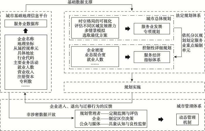