侯文娟 , 高江波, 彭韬
HOU Wenjuan, GAO Jiangbo, PENG Tao
通讯作者:
收稿日期: 2015-04-25
接受日期: 2015-08-25
网络出版日期: 2016-03-25
版权声明: 2016 地理科学进展 《地理科学进展》杂志 版权所有
基金资助:
作者简介:
作者简介:侯文娟(1989-),女,山东莱芜人,博士研究生,主要从事喀斯特生态系统脆弱性及地表水热过程等方面研究,E-mail: houwj_13b@igsnrr.ac.cn。
展开
摘要
特殊的地质背景与生态环境叠加强烈的人类活动,导致中国西南喀斯特地区生态系统呈现显著的脆弱性特征。从生态系统敏感性和适应性角度出发,喀斯特生态系统结构、功能和生境对外界扰动响应的脆弱性特征研究已取得一定进展,尤其是借助物种多样性、生态系统生产力、土壤水分/养分等指标揭示了喀斯特生态系统对土地利用/覆被变化、石漠化等过程的敏感性等方面,但综合野外试验、数值模拟、数理统计等手段的生态系统敏感性定量化研究仍较薄弱。在生态系统适应性方面,虽然具有喜钙、耐旱以及石生等特性的植物种群通过形态结构和生理功能的自我调节能够呈现出对岩溶环境的适应性,但喀斯特生态系统对人类干扰和气候变化等环境胁迫响应的适应机制仍缺乏长期的生物及理化过程研究。今后,应针对生态系统结构、功能、生境间的正反馈机制,增强系统组分的耦合分析,加强喀斯特生态系统脆弱性驱动机制研究与定量评估,突出系统脆弱性在石漠化遏制和生态恢复重建中的关键地位。
关键词:
Abstract
During the past decades, due to the intensified human disturbance and its special geological background and ecological environment, karst ecosystem in the southwestern part of China exhibited significant vulnerability, which hinders the sustainable development of the social-economic-ecological system of the region. Based on system sensitivity and adaptability, a large number of studies have investigated the vulnerability of karst ecosystem structure, function, and habitat to external disturbance. Especially, indicators of ecosystem diversity, key species, productivity, and soil physical/chemical properties were applied to reveal ecosystem sensitivity to land use/cover change and rocky desertification. However, research on quantification of ecosystem sensitivity by field experiment, mechanism models, and mathematical statistics, is less advanced. Although some karst-suitable plants present adaptability to karst drought environment by self-regulation of morphological structure and physiological function, the ecosystem adaption mechanism or biophysical/biochemical processes in response to environmental threat (e.g. human disturbance and climate change) remain unclear. Due to the close interaction of ecosystem structure, function, and habitat, future research should examine the response of coupled ecosystem components to promote the study of driving mechanism and quantitative assessment of karst ecosystem vulnerability. Furthermore, research on ecosystem vulnerability at different succession stages of karst rocky desertification needs to be strengthened to advance rocky desertification control and ecological restoration and reconstruction.
Keywords:
随着全球变化研究的兴起,脆弱性已成为全球环境变化及可持续发展科学领域关注的热点问题之一(Turner et al, 2003)。脆弱性是一种易受到不利影响的特性,主要包括对外界干扰的敏感性和适应性的缺乏等内容(IPCC, 2014)。近年来,社会经济飞速发展所带来的气候变化、生物多样性锐减、环境污染、土地荒漠化等问题,导致生态系统敏感性增强,抗干扰与适应能力减弱,受损后难以恢复,呈现出脆弱性特征(Li et al, 2010; Zhou et al, 2013)。喀斯特地区是世界主要生态脆弱带之一,其生态环境问题是当今国际地学研究的热点(袁道先, 2001; 陈洪松等, 2013)。中国西南喀斯特地区是全球三大喀斯特集中区(欧洲地中海沿岸、美国东部、东南亚)中连片裸露碳酸盐岩面积最大的地区(Sweeting, 1995),其自身独特的地质背景、二元水文结构导致地表土被薄且不连续,地上地下连通性好、水文过程变化迅速,水、土资源空间分布不匹配,水热因子高度时空异质性,氮、磷、钾极度缺乏的高钙/镁土壤环境,生态系统可恢复性难等;加之该区贫困人口相对集中,人地矛盾非常突出,在资源开发和经济发展过程中存在不合理开发和破坏生态平衡的行为(Wang et al, 2004; 王世杰等, 2007)。因此,在岩溶干旱环境下,中国西南喀斯特石漠化现象严重,生态系统趋于逆向演替,脆弱程度日益加剧(Ferlan et al, 2011; Wen et al, 2011)。
近年来,针对中国西南喀斯特地区生态系统脆弱性开展了一系列研究,涉及生态系统脆弱性的评价与管理方面;而脆弱性评价作为管理的基础(刘燕华等, 2001),已成为生态系统脆弱性研究工作的重中之重,这也是本文侧重综述的方面。具体来说,主要内容包括基于生态系统物理、化学和生物过程剖析喀斯特生态系统脆弱性的内涵和本质(李阳兵, 王世杰等, 2006; Chen et al, 2012; 汪明冲等, 2014; Jiang et al, 2015),以及基于空间和区域视角的喀斯特生态系统脆弱性的定量评估(Huang et al, 2006; 魏兴萍等, 2014);评估的方法手段涵盖针对微观过程的定点观测、野外和室内试验、数值模拟,针对区域生态系统脆弱性评价的多源数据融合、综合评估指标体系构建、数理统计方法、地理信息系统等(Wang Y X et al, 2007; Butscher et al, 2009; Jiang et al, 2009; 贺祥, 2014);相关研究从不同尺度水文过程、土壤流失、植被退化等角度刻画了喀斯特生态系统的脆弱性,且结果大多表明人类的不合理土地利用活动是该区生态系统脆弱性加剧的主导因素(Yang et al, 2011; Zhao et al, 2012; 刘春等, 2014)。
结构和功能是生态系统重要特征,任何生态系统须凭借一定的结构实现其功能并影响其效果,同时生境条件又是生态系统正常运作的基础。一般来说,生态系统结构越复杂、功能越强大、生境条件越优越,则其抵御干扰能力就越强,稳定性越高,脆弱性程度越低(李双成等, 2005; 伍光和等, 2008)。因此,生态系统生境条件、结构、功能作为表征生态系统健康状况的重要组分,其优劣程度可系统反映出生态系统脆弱性的状况及其形成机制。然而,目前喀斯特生态系统脆弱性研究大多集中在该区特殊的生态系统各组分脆弱性的外在表现上(苑涛等, 2011),通过多要素综合揭示喀斯特生态系统脆弱性机制的研究尚显薄弱。为此,本文在剖析喀斯特生态系统脆弱性特征的基础上,从喀斯特生态系统结构、功能与生境的角度出发,综合考虑系统敏感性与适应性,归纳总结喀斯特生态系统脆弱性研究现状与既有进展,提出其中存在的科学问题,进而展望未来重点研究方向,以期为喀斯特地区石漠化遏制及生态恢复重建提供科学依据。
针对中国西南喀斯特地区特殊的地质背景、典型的二元水文结构、特有的植物群落,该区生态系统脆弱性特征可以归纳为:以岩石—土壤系统为本底特征,其中的关键驱动机制是地表—地下二元水文结构,而生态系统脆弱特征直接表现在岩溶植被的结构与类型方面。
(1) 脆弱本底:岩石—土壤系统
喀斯特坡地土壤和下伏碳酸盐岩之间为土—石直接突变接触,岩层孔隙和空洞发育(张信宝等, 2010)。岩溶区碳酸盐岩中极低的酸不溶物含量使成土速率低,每形成1 cm厚的风化土层需要4000余年,慢者需要8500 年,较非岩溶山区慢10%~80%,且厚度分配不均、异质性强、土地贫瘠(王巨等, 2011)。此外,显著的差异性风化使风化前缘或基岩面强烈起伏,形成大量的岩溶洼地、裂隙等,导致分布于各种地貌中的土壤异质性强;而且这种地质地貌结构易使土壤塌陷、积聚至地下空间,导致碳酸盐岩地区表层土壤大量丢失(孙承兴等, 2002),这是导致喀斯特石漠化和生态系统脆弱的地质 背景。
(2) 关键驱动:二元水文结构
碳酸盐岩地区化学溶蚀作用强烈,组成坡地的碳酸盐岩岩层孔隙和孔洞发育成熟,坡地地表径流易于入渗转化为地下径流(彭韬等, 2008),且壤中流极易通过“筛孔”渗入表层岩溶带,最终都进入地下暗河系统,形成岩溶地区独特的地表—地下的二元水文地质结构。“地高水低、雨多地漏、石多土少和土薄易旱”是其真实写照,致使雨量充沛的西南岩溶山区成为特殊干旱缺水区(李阳兵, 邵景安等, 2006)。这种水文格局一方面易使地表干旱缺水;另一方面,由于各地段地下管网的通畅性差异很大,一遇强降雨又很容易在低洼处堵塞造成局部涝灾,这实质上也是喀斯特山区环境承灾的阈值弹性小和生态环境脆弱的反映(王世杰等, 2003)。
(3) 直观表现:岩溶植被
在岩溶山区基岩裸露、土体浅薄、水分下渗严重等环境背景下,经过严格的自然选择,具有喜钙、耐旱以及石生等特性的植物种群生存下来(曹建华等, 2005)。由于植物无法获得充足的水分,植被的生长发育受到限制,因此喀斯特生态系统的树木胸径、树高的生长具有速率慢、绝对生长量小,种间、个体间生长过程差异较大,以及生物多样性较低等特点(朱守谦, 1997)。有研究表明,根据西南地区森林普查资料的估算和分析结果得出喀斯特森林的生物量低于非喀斯特森林(于维莲等, 2010);在相同的生物气候条件下,喀斯特土层浅薄和水分下渗限制了植物的生长,因此植被群落一旦破坏就有可能难以恢复,进而导致生态系统功能紊乱,脆弱性增强。
近年来,人口的迅速增长与有限的耕地资源形成了尖锐的人地矛盾,导致毁林开荒、陡坡耕作、过度放牧等现象加剧(Lucrezi et al, 2014),原有的生态平衡遭到破坏,生态系统脆弱性特征明显,近年频发的地质灾害和石漠化现象就是该区生态脆弱性的具体体现。归根结底,上述现象产生的原因是由于人类不合理的开发利用导致原本脆弱的生态系统结构和功能的破坏以及生境的恶化。本文将基于喀斯特生态系统结构—功能—生境研究框架,从系统敏感性(即系统受外界扰动的影响程度)与适应能力(即外界扰动的自我调节能力)角度,阐述喀斯特地区生态系统脆弱性研究现状与进展。
生物多样性作为表征生态系统结构的一项重要指标,与物理环境相结合共同构成生命支持系统和人类社会经济发展的物质基础。一般来说生态系统的生物种类越多,营养结构越复杂,对外界干扰的抵御能力越强,稳定程度越高(Loreau et al, 2013);反之脆弱程度就愈大。对喀斯特地区生物多样性特征、重建机制的研究显示,喀斯特地区每个群落的植物种类都不多(2~4种),物种多样性水平不高(韦锋, 2010; Li C et al, 2013),尤其在一些为治理石漠化而植树造林的人工种植林区,植被的物种多样性水平特别低(Tang et al, 2010);且随着石漠化程度的加剧,植被的物种组成呈递减趋势,物种多样性下降(杜有新, 2011; 盛茂银等, 2015)。喀斯特地区石灰岩植物区系岩溶特征种(岩溶专有种+岩溶适宜种或广义专有种)占区系总种数的20%~30%,如此高比例的岩溶专有种显示了石灰岩植物区系和生物多样性极其特殊,若生境遭破坏,这些岩溶专有种会首先丧失,生态系统将受到严重威胁(朱华, 2007)。例如喀斯特地区的石生性植物(斜叶榕Ficus tinctoria,假苹婆Sterculia lanceolata等)是经过长期的适应过程在石缝中生长起来,一旦毁坏很难通过人工造林等方式恢复(任海等, 2002)。此外,关键种在生物群落内也起着重要作用,对贵州茂兰喀斯特森林样地主要关键种的结构和格局分析表明,主要关键种在高度异质资源位上的分化有助于促进森林的多物种共存和群落的稳定性(张忠华, 2010),但其微小变化可能导致群落或生态系统过程发生较大变化(Paine, 1969; Sanford, 1999)。
喀斯特生态系统的动物群落同样担负着物质循环和能量流动的使命,其中,土壤动物对生态系统的稳定与恢复发挥着重要作用。在贵州喀斯特高原,可改善土壤理化性质的腐蚀性土壤动物寡毛纲线蚓,它只在无石漠化样地出现且数量稀少(王仙攀等, 2012);而且伴随着干扰强度的加大,石漠化程度的加剧,环境不断恶化,喀斯特区土壤动物的物种数和个体数呈现减少趋势(熊康宁等, 2012)。尤其是土壤中的一些优势类群,其数量随着喀斯特植被的退化明显减少,其中还有些常见类群和稀有类群是生态幅小的狭适类群, 对生态环境反应特别敏感(樊云龙等, 2010)。此外,在西南气候干旱化趋势加重的影响下,土壤动物的年度变化波动较大,土壤动物个体总数的水平和垂直分布明显下降,多样性、均匀性、优势度和丰富度指数急剧降低(赵志成等, 2011)。
在喀斯特特殊的生境条件下,植物为承受岩溶干旱和土壤高钙的双重胁迫,在生存过程中改变了自身的结构以及生理生化过程,通过复杂多样的响应机制(交叉适应)获得抗逆性以适应环境(Levitt, 1980)。例如,喀斯特地区的植物为适应特殊的环境,其叶片结构具有一系列的旱生特点:表皮细胞旱化(上表皮具凹槽结构,下表皮具茂密表皮毛)、叶肉分化明显(李强, 2007);植物的根系在宽裂隙维持较高密度,窄小裂隙迫使其发展为二态根垫(Schwinning, 2010),尤其是乔灌木具有发达而强壮的根系,能攀附岩石、穿透裂隙,吸收储存在岩石空隙、裂隙中的水分和养分(Stothoff et al, 1999; Perrin et al, 2003)。
生态系统具有物质循环、能量流动、信息传递等基本功能,三者相互联系、紧密结合使生态系统得以存在和发展,其中能量流动和信息传递主要以物质循环为承载(伍光和等, 2008)。当前,针对喀斯特生态系统能量流动及信息传递的研究仍付之阙如,即使有些关于能量流动的结果,也多归属于物质循环研究,因此这里阐述的生态系统功能主要是针对生态系统有机物质的生产以及营养元素的循环。
净第一生产力(NPP)、净生态系统生产力(NEP)是体现植物活动状况的重要变量,也是表征生态系统生产功能和固碳功能的主要指标。结合野外定位观测和模拟试验方法,发现喀斯特地区不同植被覆被类型生产力整体水平与非喀斯特地区相比,均较低(Liu et al, 2013)、对外界扰动的敏感度更高(黄晓云等, 2013);土地利用/覆被变化对有机生产力价值(OPV)的影响研究表明,随石漠化加剧,生态系统生产功能显著降低(Zhang et al, 2010; 李森等, 2010);不同气候因子的影响程度有明显差异,其中NEP对于气温的敏感度高于降水(马建勇等, 2013),若未来气候继续朝暖干化发展,碳汇能力可能会进一步减弱(庞瑞等, 2012)。
在营养元素的生物化学循环方面,已有研究利用元素循环系数、吸收系数及利用系数等来表征生态系统养分循环的特征,循环系数越大,周转期越短,说明元素归还快,利用效率越高(张希彪等, 2006)。研究表明,喀斯特区马尾松群落的各营养元素的循环系数(0.19~0.45)要显著低于鼎湖山马尾松群落(0.68~0.83) (李茜等, 2008);而且随着喀斯特生态系统不断退化,N和P元素的吸收率和分解率呈现明显下降趋势(杜有新等, 2010),此外,土壤中营养矿物元素易受外界环境的变化而发生迁移,S、Cl、Na、Ca、Mg、Si等元素易发生外迁迁移或向下淋溶,并且随着外界水分和热量变化的增强,其中物质的迁移越来越强烈,加重了浅层耕作土中这些矿物质营养元素的贫化(陈武等, 2010)。
经过长期的自然和人为选择,喀斯特生态系统中部分植物通过自身生理生化过程与功能调节逐渐适应特殊的生态环境。例如,有研究表明:适当浓度的钙、水胁迫下忍冬属植物能够通过增加体内叶绿素含量、增加渗透压、提高抗氧化能力来避免干旱造成的伤害(李强, 2007),且具有气孔排钙,腺体、表皮毛、胞间及细胞壁储钙等多种方式适应富钙环境(吴耿, 2011)。此外,由于不同类型植被的光合速率、水分利用效率等对环境变化响应的灵敏度具有差异性(邓彭艳等, 2010),因此基于不同植被类型(森林、灌木、草地等)代表性样地,深入分析植被对环境胁迫的适应机制,可进行植被恢复与生态重建的适用性评估(Liu et al, 2012)。例如中国科学院西双版纳植物园通过对喀斯特地区植物生理生态适应性的研究,正在推广一种适宜石漠化山地生态重建的珍贵油料作物——星油藤(Plukenetia volubilis)(曹坤芳等, 2014)。由于植被群落对石漠化治理初期意义重大,目前关于生态系统适应性的研究多针对植物群落,而较少关注其他组分的适应机制。
生境是指(Grinnell, 1917)生物出现的环境空间范围,一般指生物生活的生态地理环境,主要包括气候、地形、土壤等环境因子。其中,在喀斯特地区土地利用与石漠化过程中,变化最为显著的是土壤的理化性质。岩溶石山区水文地质的独特性在于其空间介质具有地表和地下双层结构,地表、地下水关系密切,水源容易流失于地下,因而作为重要生境条件的土壤水分成为喀斯特生态系统退化的重要方面和恢复重建的限制因子。通过野外采样和室内实验,对喀斯特地区土壤水分变异的研究表明,受土地利用方式、人为活动等诸多因素的影响,土壤稳定入渗率、近饱和导水率及土壤水分的变异程度整体处于中度及以上水平(Chen et al, 2012),而且随石漠化程度的加剧,土壤表层含水量逐渐下降(张继光等, 2008; 周炼川, 2009; Chen et al, 2010);在极端事件影响方面,贵州高原区特大少水年的持续干旱使得次生林20~40 cm土层含水量一度达到极低值(杜雪莲等, 2008)。此外,石漠化程度的加剧也导致了土壤机械组成的变化,最明显的是砂粒含量的下降,不利于土壤团粒结构形成;表层土壤的团聚体稳定性劣化,抗水蚀能力降低,进而影响植物的生长发育(杨新强, 2011; 马菁, 2012; 张磊等, 2015)。
基于喀斯特的地质水文背景和土壤母岩特性,土壤养分状况易受到自然环境的影响而发生变化,再叠加人为干扰,其土壤养分及微生物生物量碳、氮、磷等都呈现极显著的退化(魏亚伟等, 2010; 黄金国等, 2012)。研究表明,喀斯特地区不同土壤和植被组合类型下土壤有机质中稳定碳同位素的变化范围差距大(Zhu et al, 2008);而且随着喀斯特地区石漠化程度加剧,土壤活性有机碳以及氮磷钾等养分呈显著下降趋势(卢红梅等, 2009; 李孝良等, 2010);同时土壤pH值也逐渐变小,本为富钙偏碱性的土壤酸性增强(杨新强等, 2011; 张承琴等, 2014);而且,土地利用变化对土壤理化性质的影响明显大于其他地区,土壤受到干扰后要恢复到干扰前土壤养分水平需要更长时间(蒋勇军等, 2005)。
此外,针对土壤理化性质对外界胁迫的非线性响应问题,有研究结果显示,喀斯特石漠化过程中的土壤理化性质并非不断退化,而是表现出先退化后稳定的过程。究其原因,应该与石漠化环境裸露岩石的聚集效应有关,即裸露的岩石将大气沉降的养分及其岩溶产物汇聚到周围的土壤中(盛茂银等, 2013)。
中国西南喀斯特地区独特的自然地理环境,以及频繁的人类活动,导致喀斯特生态系统的极端复杂性,生态系统脆弱性定量评估及其形成机制研究异常困难。鉴于此,本文基于生态系统结构—功能—生境框架,借助目前已有研究中多采用的多项关键指标(表1),归纳总结了喀斯特生态系统响应外界扰动的脆弱性研究进展:喀斯特生态系统脆弱性长期以来受到广泛关注,但相关研究大多聚焦于生态系统敏感性特征,借助野外试验、机理模型和数理统计进行敏感程度的定量化研究仍然薄弱;对于生态系统适应性而言,尽管已有研究揭示了植物可通过结构调整、生化调节等途径适应特殊的岩溶环境,但对于包括人类扰动、气候变化在内的环境胁迫下的生物物理/化学适应机制研究仍非常欠缺,难以支撑石漠化地区生态恢复重建工作。
表1 喀斯特生态系统脆弱性已有研究中采用的关键指标
Tab.1 Key indicators in previous research of karst ecosystem vulnerability
| 整体框架 | 关键指标 | |
|---|---|---|
| 生态系统 脆弱性 | 生态系统形态结构 | 生物多样性 |
| 关键种 | ||
| 群落结构 | ||
| 植物形态结构 | ||
| 生态系统关键功能 | 净第一性生产力(NPP) | |
| 净生态系统生产力(NEP) | ||
| 营养元素循环 | ||
| 生理生化过程 | ||
| 生态系统土壤生境 | 土壤机械组成 | |
| 土壤水力学性质 | ||
| 土壤养分状况 |
梳理已有相关研究,可发现生态系统结构、功能与生境之间存在密切关联与相互作用(图1),尤其是生境作为生态系统正常运行的基础,处于三者相互作用关系的核心位置。如在喀斯特地区,土壤养分各指标、pH值等的大小显著影响物种的多样性以及丰富度(Li S et al, 2013),土壤水分和碳酸钙含量也是决定植被群落结构的重要因素(Yue et al, 2010);同时,植物的物种多样性可以有效维持较高的土壤养分状况,促进生态系统净第一生产力增加,提升生态系统的稳定性(Wang Z H et al, 2007),在石漠化地区优化植被覆盖状况,可改善土壤微生物量碳、呼吸状况等,创造更好的土壤环境条件,最终也有利于植被恢复和生态重建(Wei et al, 2011)。
图1 基于生态系统结构—功能—生境的生态系统脆弱性研究
Fig.1 Ecosystem vulnerability study based on the structure-function-habitat framework
(1) 重视基于多要素相互作用的喀斯特生态系统脆弱性研究
尽管生态系统结构、功能、生境间存在相互影响,但以往对于喀斯特生态系统脆弱性的研究,多是基于单方面、单要素,尚缺乏多要素耦合的系统研究。今后应针对西南喀斯特独特的地质背景和二元水文结构,将喀斯特生态系统结构(物种多样性、植被覆盖度等)、功能(物质循环、能量流动等)、生境(气候环境、土壤理化条件等)纳入生态系统脆弱性研究的统一框架下,结合人与环境相互作用的影响进行综合研究。例如,人类的滥砍滥伐使得植被覆盖度发生变化,土壤孔隙度、导水性能也发生改变,最终会影响土壤含水量;植被覆盖度的变化也会使得地表反照率变化,影响热量循环,从而会引起生境的变化。
(2) 推进西南喀斯特生态系统脆弱性的过程与机制研究
在喀斯特地区生态系统脆弱性研究中,关于外界环境干扰下生态系统的物种多样性、植被覆盖度、生物量以及土壤环境条件等的变化已有诸多探讨,但定量评估脆弱性方面的研究仍需加强,尤其要重视借助野外观测、室内实验和数理模型等手段,对西南喀斯特生态系统水分、热量、养分循环及其权衡与协同过程的深入研究,以揭示生态系统脆弱性形成和驱动过程与机制。特别需要指出的是,在喀斯特生态系统各组分响应环境胁迫的适应性机制方面,由于生物及理化过程观测和试验时间尺度较短,仅能在一定程度上说明喀斯特生态系统如何适应岩溶环境,今后应加强阐释在长期的人类干扰和气候变化影响下,喀斯特生态系统的适应机制研究。
(3) 增强石漠化演替过程中的脆弱性研究,推动喀斯特生态系统恢复重建
西南喀斯特石漠化本质上是生态系统退化,其发生、发展过程是人类活动破坏生态平衡所导致的系统脆弱性增强,包括结构退化(如覆盖度和多样性降低)、功能衰退(如生产力下降)、生境变劣(如土壤理化性质恶化)。已有关于喀斯特生态系统响应石漠化的脆弱性研究,大多基于“空间代时间”的思路,根据不同样点间的特征差异揭示系统响应的脆弱性,但此类方法难以揭示石漠化连续演变过程,应加强针对不同石漠化演替阶段的生态系统脆弱性研究。由于退化生态系统的恢复重建力求实现生境逐步改善、物种逐步协调与多样、功能逐步优化,因此,加强石漠化胁迫下生态系统脆弱性研究,揭示不同石漠化程度下的生态系统结构、功能与生境特征与变异机制,有助于推动喀斯特石漠化地区生态系统的恢复重建。
The authors have declared that no competing interests exist.
| [1] |
|
| [2] |
热带岩溶植物生理生态适应性对于南方石漠化土地生态重建的启示 [J].https://doi.org/10.1360/052013-234 URL [本文引用: 1] 摘要
岩溶地质在我国分布广泛,特别 是西南地区连片分布着世界上面积最大的岩溶地貌.由于长期人为活动的影响,目前我国南方地区岩溶石漠化土地面积已达1.2×10⁵ km2,导致当地生态条件恶化,经济、社会发展面临严重困难.南方岩溶山地土层薄,养分贫瘠,保水性能差.对热带岩溶森林开展了一系列生理生态研究,研究 结果对南方岩溶石漠化山地生态重建有启发意义.研究结果暗示,岩溶生境常绿、落叶木本植物和木质藤本植物共存对于维持生态系统水分平衡有重要意义.常绿植 物枝条木质部耐气穴化能力强,叶片耐失水性能强.落叶植物采取避旱策略,通过落叶减少旱季蒸腾和水分消耗.岩溶山地大部分植物具有很深的根系,藤本植物根 系更深,旱季能利用地下深层岩石下和缝隙水.有些植物如木棉、董棕利用树干储存水保持旱季必要的生理代谢.岩溶山地木本植物叶片和枝条木质部结构和生理功 能的密切关联对于适应水分胁迫起重要作用.热带岩溶植物可能普遍缺乏锌、钾元素,这方面问题需引起重视和研究.藤蔓植物可以利用石漠化岩溶山地局部水土资 源和丰富的生长空间和光照资源,并且大多数藤蔓植物气孔调节能力强,对强光的适应和利用能力强,是石漠化山地生态重建的理想植物材料.目前中国科学院西双 版纳植物园正在推广的一种珍贵的油料植物—星油藤,可以作为南方热区石漠化山地生态重建的理想植物材料.石漠化土地的重建要合理利用不同功能类群植物,特 别是岩溶生境的乡土植物,最好构建多层复合群落.
Implications of the ecophysiological adaptation of plants on tropical karst habitats for the ecological restoration of desertified rocky lands in southern China [J].https://doi.org/10.1360/052013-234 URL [本文引用: 1] 摘要
岩溶地质在我国分布广泛,特别 是西南地区连片分布着世界上面积最大的岩溶地貌.由于长期人为活动的影响,目前我国南方地区岩溶石漠化土地面积已达1.2×10⁵ km2,导致当地生态条件恶化,经济、社会发展面临严重困难.南方岩溶山地土层薄,养分贫瘠,保水性能差.对热带岩溶森林开展了一系列生理生态研究,研究 结果对南方岩溶石漠化山地生态重建有启发意义.研究结果暗示,岩溶生境常绿、落叶木本植物和木质藤本植物共存对于维持生态系统水分平衡有重要意义.常绿植 物枝条木质部耐气穴化能力强,叶片耐失水性能强.落叶植物采取避旱策略,通过落叶减少旱季蒸腾和水分消耗.岩溶山地大部分植物具有很深的根系,藤本植物根 系更深,旱季能利用地下深层岩石下和缝隙水.有些植物如木棉、董棕利用树干储存水保持旱季必要的生理代谢.岩溶山地木本植物叶片和枝条木质部结构和生理功 能的密切关联对于适应水分胁迫起重要作用.热带岩溶植物可能普遍缺乏锌、钾元素,这方面问题需引起重视和研究.藤蔓植物可以利用石漠化岩溶山地局部水土资 源和丰富的生长空间和光照资源,并且大多数藤蔓植物气孔调节能力强,对强光的适应和利用能力强,是石漠化山地生态重建的理想植物材料.目前中国科学院西双 版纳植物园正在推广的一种珍贵的油料植物—星油藤,可以作为南方热区石漠化山地生态重建的理想植物材料.石漠化土地的重建要合理利用不同功能类群植物,特 别是岩溶生境的乡土植物,最好构建多层复合群落.
|
| [3] |
岩溶山区水分时空异质性及植物适应机理研究进展 [J].https://doi.org/10.5846/stxb201112011836 Magsci [本文引用: 1] 摘要
西南岩溶地区虽然降水充沛,但因具有二元水文结构,地表水大量渗漏、地下水深埋,加上土层浅薄且分布不连续、土壤储水能力低,岩溶干旱严重,水分亏缺仍然是植被恢复重建的关键限制因子。如何有效地进行植被的恢复重建和实现水土资源的协调利用,是该地区石漠化综合治理面临的主要难题。由于地质背景的特殊性、地形地貌的复杂性和生境的高度异质性,岩溶山区水分运移过程与其他类型区显著不同,亟需综合考虑岩性、地形地貌、土壤与岩石分布、植被等因素的影响。在简要介绍岩溶山区土壤-岩石环境特征的基础上,综述了降雨入渗产流规律、水分时空异质性、植物水分来源及适应机理等几个方面的研究进展,探讨了当前研究中存在的问题,并对未来研究进行了展望。今后应以大气-植被-土壤-岩石系统为研究对象,将水分运移过程与植物的水分利用方式有机结合,综合运用土壤物理学、生态水文学、植物生理学、岩溶地质学等多学科研究手段,探讨表层岩溶带的水文调节功能及其主要影响因素,揭示坡面、小流域尺度植被与水文过程的相互作用机理,为西南岩溶山区水源涵养型植物群落的优化配置提供科学依据。
Spatio-temporal heterogeneity of water and plant adaptation mechanisms in karst regions: A review [J].https://doi.org/10.5846/stxb201112011836 Magsci [本文引用: 1] 摘要
西南岩溶地区虽然降水充沛,但因具有二元水文结构,地表水大量渗漏、地下水深埋,加上土层浅薄且分布不连续、土壤储水能力低,岩溶干旱严重,水分亏缺仍然是植被恢复重建的关键限制因子。如何有效地进行植被的恢复重建和实现水土资源的协调利用,是该地区石漠化综合治理面临的主要难题。由于地质背景的特殊性、地形地貌的复杂性和生境的高度异质性,岩溶山区水分运移过程与其他类型区显著不同,亟需综合考虑岩性、地形地貌、土壤与岩石分布、植被等因素的影响。在简要介绍岩溶山区土壤-岩石环境特征的基础上,综述了降雨入渗产流规律、水分时空异质性、植物水分来源及适应机理等几个方面的研究进展,探讨了当前研究中存在的问题,并对未来研究进行了展望。今后应以大气-植被-土壤-岩石系统为研究对象,将水分运移过程与植物的水分利用方式有机结合,综合运用土壤物理学、生态水文学、植物生理学、岩溶地质学等多学科研究手段,探讨表层岩溶带的水文调节功能及其主要影响因素,揭示坡面、小流域尺度植被与水文过程的相互作用机理,为西南岩溶山区水源涵养型植物群落的优化配置提供科学依据。
|
| [4] |
贵州典型喀斯特区土壤地球化学特征研究 [J].https://doi.org/10.3969/j.issn.1001-4810.2010.03.005 URL [本文引用: 2] 摘要
以贵州花溪党武、遵义虾子和安龙木咱3个地区的土壤为主要研究对 象,从地球化学的角度研究其土壤中相关矿物元素的含量、元素在岩-土剖面中的迁移富集特征及其风化成土系数,综合表征出研究区土壤的农业地质环境特征,并 对其矿物营养元素环境质量做出初步评价.研究结果表明,石灰土中矿物营养元素的淋溶较为强烈,有10种左右元素的含量低于中国或世界土壤化学组成中值,具 体表现为纯的碳酸盐岩所发育的土壤中矿物营养元素的含量较少,而安龙木咱地区由于其成土母质为白云质灰岩,且所处地质环境易于汇集周边淋溶出来的营养元 素,使得其土壤矿物营养元素环境质量好于其余两地,三地土壤中营养元素达标率分别为73.7%(安龙木咱)、63.1%(遵义虾子)和68.4%(花溪党 武).总体而言,碳酸盐岩风化成土作用缓慢,土层较薄,土壤营养元素含量不足,需要施用相应的矿物肥料.
Research on the property of soil geochemistry in typical karst area in Guizhou Province [J].https://doi.org/10.3969/j.issn.1001-4810.2010.03.005 URL [本文引用: 2] 摘要
以贵州花溪党武、遵义虾子和安龙木咱3个地区的土壤为主要研究对 象,从地球化学的角度研究其土壤中相关矿物元素的含量、元素在岩-土剖面中的迁移富集特征及其风化成土系数,综合表征出研究区土壤的农业地质环境特征,并 对其矿物营养元素环境质量做出初步评价.研究结果表明,石灰土中矿物营养元素的淋溶较为强烈,有10种左右元素的含量低于中国或世界土壤化学组成中值,具 体表现为纯的碳酸盐岩所发育的土壤中矿物营养元素的含量较少,而安龙木咱地区由于其成土母质为白云质灰岩,且所处地质环境易于汇集周边淋溶出来的营养元 素,使得其土壤矿物营养元素环境质量好于其余两地,三地土壤中营养元素达标率分别为73.7%(安龙木咱)、63.1%(遵义虾子)和68.4%(花溪党 武).总体而言,碳酸盐岩风化成土作用缓慢,土层较薄,土壤营养元素含量不足,需要施用相应的矿物肥料.
|
| [5] |
桂西北喀斯特地区菜豆树和红背山麻杆旱、雨季光合特性比较 [J].
<p>利用Li6400光合测定系统测定了2009年雨季(6—8月)和旱季(10—12月)桂西北喀斯特地区菜豆树、红背山麻杆叶片气体交换特征,并分析了2种植物光合速率(<em>P</em><sub>n</sub>)与叶氮及叶绿素含量的相互关系。结果表明:2种植物旱、雨季叶片<em>P</em><sub>n</sub>、蒸腾速率(<em>T</em><sub>r</sub>)、气孔导度(<em>G</em><sub>s</sub>)日变化均为单峰曲线,水分利用效率(<em>WUE</em>)日变化规律不明显;旱季叶片<em>P</em><sub>n</sub>、<em>T</em><sub>r</sub>、<em>G</em><sub>s</sub>均低于雨季(<em>P</em><0.01),<em>WUE</em>高于雨季(<em>P</em><0.01),叶氮含量及叶绿素含量旱季低于雨季(<em>P</em><0.05),这与植物通过降低<em>G</em><sub>s</sub>限制蒸腾,提高<em>WUE</em>来适应较为恶劣的环境有关;在同一季节,红背山麻杆<em>P</em><sub>n</sub>、<em>WUE</em>、叶氮及叶绿素含量均高于菜豆树(<em>P</em><0.05),具有更强的光合及水分利用能力,在喀斯特生境中更有竞争优势;2种植物在相同季节及同种植物在不同季节<em>P</em><sub>n</sub>与各环境因子的相关系数不同,光辐射强度(<em>PAR</em>)是影响<em>P</em><sub>n</sub>的主导因素。</p>
Photosynthetic characteristics of Radermachera sinica and Alchornea trewioides in karst regions of northwest Guangxi, China in dry and rainy seasons [J].
<p>利用Li6400光合测定系统测定了2009年雨季(6—8月)和旱季(10—12月)桂西北喀斯特地区菜豆树、红背山麻杆叶片气体交换特征,并分析了2种植物光合速率(<em>P</em><sub>n</sub>)与叶氮及叶绿素含量的相互关系。结果表明:2种植物旱、雨季叶片<em>P</em><sub>n</sub>、蒸腾速率(<em>T</em><sub>r</sub>)、气孔导度(<em>G</em><sub>s</sub>)日变化均为单峰曲线,水分利用效率(<em>WUE</em>)日变化规律不明显;旱季叶片<em>P</em><sub>n</sub>、<em>T</em><sub>r</sub>、<em>G</em><sub>s</sub>均低于雨季(<em>P</em><0.01),<em>WUE</em>高于雨季(<em>P</em><0.01),叶氮含量及叶绿素含量旱季低于雨季(<em>P</em><0.05),这与植物通过降低<em>G</em><sub>s</sub>限制蒸腾,提高<em>WUE</em>来适应较为恶劣的环境有关;在同一季节,红背山麻杆<em>P</em><sub>n</sub>、<em>WUE</em>、叶氮及叶绿素含量均高于菜豆树(<em>P</em><0.05),具有更强的光合及水分利用能力,在喀斯特生境中更有竞争优势;2种植物在相同季节及同种植物在不同季节<em>P</em><sub>n</sub>与各环境因子的相关系数不同,光辐射强度(<em>PAR</em>)是影响<em>P</em><sub>n</sub>的主导因素。</p>
|
| [6] |
喀斯特高原区土壤水分的时空变异分析: 以贵州清镇王家寨小流域为例 [J].
以贵州喀斯特高原区王家寨峰丛洼地小流域为研究对象,于2005 年11月至2006年12月测定了小流域内不同植被的土壤水分年变化,探讨不同植被类型峰丛坡面土壤水分的时空变化规律,并且与同属小流域内的非喀斯特土 山进行对比研究.结果表明:各种植被类型的土壤水分年变化趋势大致相同,主要受降雨和蒸散过程的影响,但变化幅度存在差异,次生林和灌木灌丛变化幅度大于 非喀斯特土山和稀疏灌草丛.雨后连续晴天各植被土壤水分变化幅度呈相同格局.观测期内土壤水分的动态变化具有明显的季节性,划分为4个阶段:冬季平稳低墒 期、春季及夏初蓄水期、夏季及秋初消耗期及秋季及冬初回升期.各植被土壤剖面水分存在差异,次生林、灌木灌丛坡面土壤剖面含水量从表层到深层表现为降低 型,稀疏灌草丛、非喀斯特土山则为增加型.同一坡面不同坡位间土壤水分差异不显著,反映了喀斯特地区复杂多变的小生境和其独特的二元结构水文系统.
Space-time distribution of soil water in a karst area: A case study of the Wangjiazhai catchment, Qingzhen, Guizhou Province [J].
以贵州喀斯特高原区王家寨峰丛洼地小流域为研究对象,于2005 年11月至2006年12月测定了小流域内不同植被的土壤水分年变化,探讨不同植被类型峰丛坡面土壤水分的时空变化规律,并且与同属小流域内的非喀斯特土 山进行对比研究.结果表明:各种植被类型的土壤水分年变化趋势大致相同,主要受降雨和蒸散过程的影响,但变化幅度存在差异,次生林和灌木灌丛变化幅度大于 非喀斯特土山和稀疏灌草丛.雨后连续晴天各植被土壤水分变化幅度呈相同格局.观测期内土壤水分的动态变化具有明显的季节性,划分为4个阶段:冬季平稳低墒 期、春季及夏初蓄水期、夏季及秋初消耗期及秋季及冬初回升期.各植被土壤剖面水分存在差异,次生林、灌木灌丛坡面土壤剖面含水量从表层到深层表现为降低 型,稀疏灌草丛、非喀斯特土山则为增加型.同一坡面不同坡位间土壤水分差异不显著,反映了喀斯特地区复杂多变的小生境和其独特的二元结构水文系统.
|
| [7] |
退化喀斯特生态系统植被群落特征及氮磷养分有效性: 以贵州省普定县为例 [D].Characteristics of vegetation communities and nitrogen and phosphorus availability in degraded ecosystems in karst region in Guizhou, China: A case study with different ecosystems under vegetation decline from Puding, Guizhou [D]. |
| [8] |
黔中喀斯特山区退化生态系统生物量结构与N、P分布格局及其循环特征 [J].
喀斯特生态系统退化导致植被群落结构简单、系统生态功能逐渐丧失与稳定性不断下降,这些退化特征皆与系统生物量结构和生物地球化学循环特征密切相关。采用实地调查和典型取样方法,探讨了贵州省普定县3个不同退化程度的喀斯特生态系统生物量结构与养分分布格局。结果表明:(1) 随着生态系统不断退化,植被地上部分生物量和土壤有效态养含量呈下降趋势,植物营养物质通过凋落物返还土壤的比例也呈类似的趋势,而细根和草本植物等活性生物组分的生物量却呈现上升趋势。(2) 对应于生物量结构的变化,各组分主要养分储量也呈现相似的变化特征。乔木林枯落物层养分(N和P)累积量显著高于草本层和细根部分,而灌木林和灌草丛系统草本层和细根部分的养分储量超过或接近枯落物层。(3) 随着生态系统不断退化,N和P的生物吸收率、生物返还率、生物迁移率和生物分解率出现明显变化,生物吸收率和生物分解率呈现明显下降趋势,而生物迁移率和生物返还率却表现出上升趋势。
Partitioning of vegetation biomass, nutrient storage and cycling of degraded ecosystems from mountainous karst region, central Guizhou, China [J].
喀斯特生态系统退化导致植被群落结构简单、系统生态功能逐渐丧失与稳定性不断下降,这些退化特征皆与系统生物量结构和生物地球化学循环特征密切相关。采用实地调查和典型取样方法,探讨了贵州省普定县3个不同退化程度的喀斯特生态系统生物量结构与养分分布格局。结果表明:(1) 随着生态系统不断退化,植被地上部分生物量和土壤有效态养含量呈下降趋势,植物营养物质通过凋落物返还土壤的比例也呈类似的趋势,而细根和草本植物等活性生物组分的生物量却呈现上升趋势。(2) 对应于生物量结构的变化,各组分主要养分储量也呈现相似的变化特征。乔木林枯落物层养分(N和P)累积量显著高于草本层和细根部分,而灌木林和灌草丛系统草本层和细根部分的养分储量超过或接近枯落物层。(3) 随着生态系统不断退化,N和P的生物吸收率、生物返还率、生物迁移率和生物分解率出现明显变化,生物吸收率和生物分解率呈现明显下降趋势,而生物迁移率和生物返还率却表现出上升趋势。
|
| [9] |
喀斯特高原不同植被演替阶段土壤动物群落特征 [J].https://doi.org/10.3969/j.issn.1008-2786.2010.02.015 URL [本文引用: 1] 摘要
选择贵州喀斯特高原三个典型地貌单元作为研究区,于 2009-05对不同植被演替阶段的土壤动物群落进行研究.共获土壤动物3 992只,隶属于5门10纲26目,共31个类群,优势类群为弹尾目(Collembola)、甲螨亚目(Oribatida)、中气门亚目 (Mesostigmata);常见类群为前气门亚目(Prostigmata)、膜翅目(Hymenoptera)、鞘翅目(Coleoptera)、 半翅目(Hemiptera )、近孔寡毛目(Plesiopora)、双翅目(Diptera)、双尾目(Diplura).研究结果表明,随着喀斯特植被的不断退化,土壤动物数量 不断减少,表现为林地>灌丛>草地>石漠化地;类群数亦呈减少趋势.各演替阶段土壤动物表聚性明显,但人为干扰(如翻耕等)可导致土壤动物出现逆分布现 象.土壤动物多样性分析表明,中小型土壤动物的多样性指数从林地到石漠化地逐渐减小.
Research on soil fauna community characteristics at different vegetation successions in the karst plateau of Guizhou Province [J].https://doi.org/10.3969/j.issn.1008-2786.2010.02.015 URL [本文引用: 1] 摘要
选择贵州喀斯特高原三个典型地貌单元作为研究区,于 2009-05对不同植被演替阶段的土壤动物群落进行研究.共获土壤动物3 992只,隶属于5门10纲26目,共31个类群,优势类群为弹尾目(Collembola)、甲螨亚目(Oribatida)、中气门亚目 (Mesostigmata);常见类群为前气门亚目(Prostigmata)、膜翅目(Hymenoptera)、鞘翅目(Coleoptera)、 半翅目(Hemiptera )、近孔寡毛目(Plesiopora)、双翅目(Diptera)、双尾目(Diplura).研究结果表明,随着喀斯特植被的不断退化,土壤动物数量 不断减少,表现为林地>灌丛>草地>石漠化地;类群数亦呈减少趋势.各演替阶段土壤动物表聚性明显,但人为干扰(如翻耕等)可导致土壤动物出现逆分布现 象.土壤动物多样性分析表明,中小型土壤动物的多样性指数从林地到石漠化地逐渐减小.
|
| [10] |
基于熵权灰色关联法的贵州岩溶山区人地耦合系统脆弱性分析 [J].
为了厘清岩溶山区人地耦合系统脆弱性特征,在构建岩溶山区人地耦 合系统脆弱性评价指标的基础上,运用熵权灰色关联分析法,以贵州省9个地州市为基本评价单元,对其人地耦合系统脆弱性进行定量分析与评价.结果表明: (1)敏感性维度的指标评价等级仅有黔东南州与铜仁地区属于轻度脆弱;暴露度与适应能力维度的指标评价等级仅贵阳市是轻度脆弱,其它地区均是次强度脆弱等 级.(2)各地市人地耦合系统脆弱度综合评价结果为六盘水市、毕节地区、安顺市与黔南州属于强度脆弱级;黔东南州、黔西南州、铜仁地区与遵义市属于次强度 脆弱级;贵阳市属轻度脆弱级.依据研究结果可将贵州省人地耦合系统划分为强度脆弱区、次强度脆弱区和轻度脆弱区;将各地市人地耦合系统脆弱度与其人地关系 特征的对应分析结果表明,人地耦合系统脆弱度的定量分级分析与定性分析具有较好的一致性.
Analysis on the vulnerability of coupled human-natural systems in karst mountain areas of Guizhou Province based on the entropy and gray correlation method [J].
为了厘清岩溶山区人地耦合系统脆弱性特征,在构建岩溶山区人地耦 合系统脆弱性评价指标的基础上,运用熵权灰色关联分析法,以贵州省9个地州市为基本评价单元,对其人地耦合系统脆弱性进行定量分析与评价.结果表明: (1)敏感性维度的指标评价等级仅有黔东南州与铜仁地区属于轻度脆弱;暴露度与适应能力维度的指标评价等级仅贵阳市是轻度脆弱,其它地区均是次强度脆弱等 级.(2)各地市人地耦合系统脆弱度综合评价结果为六盘水市、毕节地区、安顺市与黔南州属于强度脆弱级;黔东南州、黔西南州、铜仁地区与遵义市属于次强度 脆弱级;贵阳市属轻度脆弱级.依据研究结果可将贵州省人地耦合系统划分为强度脆弱区、次强度脆弱区和轻度脆弱区;将各地市人地耦合系统脆弱度与其人地关系 特征的对应分析结果表明,人地耦合系统脆弱度的定量分级分析与定性分析具有较好的一致性.
|
| [11] |
粤北岩溶山区石漠化过程中土壤养分变化研究 [J].
为了探讨石漠化过程对土壤养分的影响,了解粤北岩溶山区石漠化过程中土壤养分的变化规律,选择岩背镇和江英镇为调查区,按照石漠化的不同程度设置样地,系统调查了轻度、中度、重度和极重度石漠化土地表层(0~20 cm)土壤养分的变化。结果表明,石漠化过程与土壤养分状况有密切关系,随着土地石漠化的发展,土壤有机质、全N以及速效N、速效P、速效K含量呈现出显著下降趋势(P<0.05),土壤逐步贫瘠化。土壤养分含量的减少与石漠化过程形成正反馈关系,并具有退化方向的一致性和退化过程的同步性等特点。
Change of soil nutrient in process of rocky desertification in karst mountainous area of north Guangdong [J].
为了探讨石漠化过程对土壤养分的影响,了解粤北岩溶山区石漠化过程中土壤养分的变化规律,选择岩背镇和江英镇为调查区,按照石漠化的不同程度设置样地,系统调查了轻度、中度、重度和极重度石漠化土地表层(0~20 cm)土壤养分的变化。结果表明,石漠化过程与土壤养分状况有密切关系,随着土地石漠化的发展,土壤有机质、全N以及速效N、速效P、速效K含量呈现出显著下降趋势(P<0.05),土壤逐步贫瘠化。土壤养分含量的减少与石漠化过程形成正反馈关系,并具有退化方向的一致性和退化过程的同步性等特点。
|
| [12] |
气候变化背景下中国南方喀斯特地区NPP时空变化 [J].https://doi.org/10.11707/j.1001-7488.20130502 Magsci [本文引用: 1] 摘要
基于中国南方8省区喀斯特地区卫星遥感和地面气象观测资料,分析气候变化背景下中国南方喀斯特地区2000—2011年间的NPP时空变化规律,及不同土地利用类型NPP变化。结果表明: 在气候变化背景下, 2000—2005年间,研究区NPP值总体呈上升趋势,在2005年发生转折, 2006—2011年间,NPP值总体呈下降趋势; 喀斯特地区NPP的变化幅度明显大于非喀斯特区; 农田、低密度灌木林、混合用地等土地利用类型对石漠化反应敏感。
Temporal and spatial NPP variation in the karst region in south China under the background of climate change [J].https://doi.org/10.11707/j.1001-7488.20130502 Magsci [本文引用: 1] 摘要
基于中国南方8省区喀斯特地区卫星遥感和地面气象观测资料,分析气候变化背景下中国南方喀斯特地区2000—2011年间的NPP时空变化规律,及不同土地利用类型NPP变化。结果表明: 在气候变化背景下, 2000—2005年间,研究区NPP值总体呈上升趋势,在2005年发生转折, 2006—2011年间,NPP值总体呈下降趋势; 喀斯特地区NPP的变化幅度明显大于非喀斯特区; 农田、低密度灌木林、混合用地等土地利用类型对石漠化反应敏感。
|
| [13] |
典型岩溶农业区土地利用变化对土壤性质的影响: 以云南小江流域为例 [J].
<p>以云南省泸西县小江典型岩溶农业流域为研究单元,分析了流域1982~2003年土地利用的变化及定点对比分析不同土地利用变化下土壤性质的变化,结果表明:小江流域1982~2003年610.12 km<sup>2</sup>的土地利用发生了变化,变化类型主要是由未利用地向耕地、林地以及林地向耕地的转变,人口的增加、社会、经济的发展和理智的生态决策是流域土地利用变化的主要原因;林地、未利用地转变为耕地后,土壤有机质、全氮、全磷含量大幅度降低,土壤pH明显升高,全钾、速效钾含量增加;短时间的退耕还林,土壤性质变化不明显;耕地转变为园地后,土壤性质得到明显的改善;而耕地转变为石漠化土地后,土壤性质发生显著变化,土壤有机质、全氮、全磷、碱解氮、速效磷含量大幅度降低,土壤pH明显升高;同时,研究表明土地利用变化对碳酸盐岩地层中发育的土壤性质的影响强度明显大于砂页岩地层中发育的土壤,表明碳酸盐岩地层中发育的土壤十分脆弱。</p>
Impact of land use change on soil properties in a typical karst agricultural region: A case study of Xiaojiang watershed, Yunnan [J].
<p>以云南省泸西县小江典型岩溶农业流域为研究单元,分析了流域1982~2003年土地利用的变化及定点对比分析不同土地利用变化下土壤性质的变化,结果表明:小江流域1982~2003年610.12 km<sup>2</sup>的土地利用发生了变化,变化类型主要是由未利用地向耕地、林地以及林地向耕地的转变,人口的增加、社会、经济的发展和理智的生态决策是流域土地利用变化的主要原因;林地、未利用地转变为耕地后,土壤有机质、全氮、全磷含量大幅度降低,土壤pH明显升高,全钾、速效钾含量增加;短时间的退耕还林,土壤性质变化不明显;耕地转变为园地后,土壤性质得到明显的改善;而耕地转变为石漠化土地后,土壤性质发生显著变化,土壤有机质、全氮、全磷、碱解氮、速效磷含量大幅度降低,土壤pH明显升高;同时,研究表明土地利用变化对碳酸盐岩地层中发育的土壤性质的影响强度明显大于砂页岩地层中发育的土壤,表明碳酸盐岩地层中发育的土壤十分脆弱。</p>
|
| [14] |
典型喀斯特地区马尾松纯林及马尾松—阔叶树混交林营养元素生物循环研究: 以贵州龙里为例 [J].https://doi.org/10.3969/j.issn.1001-4810.2008.04.005 URL [本文引用: 1] 摘要
以龙里典型喀斯特地区马尾松纯林及马尾松-阔叶树混交林为研究对 象,研究了两个群落的生物量、营养元素贮量、分布及循环特征.结果表明:马尾松纯林、马尾松-阔叶树混交林的生物量分别为40.62t/hm2、 48.32t/hm2,混交林的乔木层总生物量比马尾松纯林高18.97%,根系生物量较纯林高65.12%.混交林乔木层各器官营养元素的含量整体大于 马尾松纯林,两群落乔木层N、P、K、S的含量表现出一致的趋势,叶>根>枝>干.混交林乔木层各元素的积累量分别比纯林高 47.97%~197.67%,凋落物层各元素贮量比纯林高85.40%~318.301%.混交林的年归还量、年存留量和年吸收量均大于马尾松纯林,且 各元素循环系数大于马尾松纯林.马尾松林与阔叶树混交可以有效地提高群落生物量和营养元素循环的能力.
Biological cycling of nutrients in Pinus forest and Pinus-Hardwood mixed forest in karst area: A case study in Longli, Guizhou [J].https://doi.org/10.3969/j.issn.1001-4810.2008.04.005 URL [本文引用: 1] 摘要
以龙里典型喀斯特地区马尾松纯林及马尾松-阔叶树混交林为研究对 象,研究了两个群落的生物量、营养元素贮量、分布及循环特征.结果表明:马尾松纯林、马尾松-阔叶树混交林的生物量分别为40.62t/hm2、 48.32t/hm2,混交林的乔木层总生物量比马尾松纯林高18.97%,根系生物量较纯林高65.12%.混交林乔木层各器官营养元素的含量整体大于 马尾松纯林,两群落乔木层N、P、K、S的含量表现出一致的趋势,叶>根>枝>干.混交林乔木层各元素的积累量分别比纯林高 47.97%~197.67%,凋落物层各元素贮量比纯林高85.40%~318.301%.混交林的年归还量、年存留量和年吸收量均大于马尾松纯林,且 各元素循环系数大于马尾松纯林.马尾松林与阔叶树混交可以有效地提高群落生物量和营养元素循环的能力.
|
| [15] |
忍冬属植物对岩溶环境的适应性研究 [D].Studies on the ecology adaptation of Floslonicerae in the karst environment [D]. |
| [16] |
典型岩溶山区土地石漠化过程: 以粤北岩溶山区为例 [J].
中国南方岩溶区是土地石漠化广为发生发展的脆弱生态区域。运用面上调查、定位观测和模拟试验相结合的方法,以粤北岩溶山区为例,从地表生态过程的角度对土地石漠化过程进行解析、研究。在轻度石漠化向极重度石漠化发展的过程中,仅2-3a,植被就从灌草混合群落退化为草本群落,物种减少76%,植被盖度降低87.2%;土壤侵蚀量逐渐加大,土壤物质不断流失和丢失,土层变薄,侵蚀模数呈10多倍、数10倍增加。岩溶坡面特殊的水文过程和水循环模式,使石漠化土地上“四水”转化迅速。随着石漠化程度加重,地表水和壤中水流失量加大,石灰岩脉动式“生长”速度加快,使基岩裸露率由30%—50%增至90%以上,最终导致土壤粗化,养分减少,生物生产量减少89%甚至更多。这表明,土地石漠化过程是由植被退化丧失过程、土壤侵蚀过程、地表水流失过程、碳酸盐岩溶蚀侵蚀过程和土地生物生产力退化过程相互联系、组合而成的土地退化过程,也是岩溶山区土地生态系统演变为石质荒漠系统的地表生态过程。
The processes of land rocky desertification in typical karst mountain area: A case study in the karst mountain area of north Guangdong [J].
中国南方岩溶区是土地石漠化广为发生发展的脆弱生态区域。运用面上调查、定位观测和模拟试验相结合的方法,以粤北岩溶山区为例,从地表生态过程的角度对土地石漠化过程进行解析、研究。在轻度石漠化向极重度石漠化发展的过程中,仅2-3a,植被就从灌草混合群落退化为草本群落,物种减少76%,植被盖度降低87.2%;土壤侵蚀量逐渐加大,土壤物质不断流失和丢失,土层变薄,侵蚀模数呈10多倍、数10倍增加。岩溶坡面特殊的水文过程和水循环模式,使石漠化土地上“四水”转化迅速。随着石漠化程度加重,地表水和壤中水流失量加大,石灰岩脉动式“生长”速度加快,使基岩裸露率由30%—50%增至90%以上,最终导致土壤粗化,养分减少,生物生产量减少89%甚至更多。这表明,土地石漠化过程是由植被退化丧失过程、土壤侵蚀过程、地表水流失过程、碳酸盐岩溶蚀侵蚀过程和土地生物生产力退化过程相互联系、组合而成的土地退化过程,也是岩溶山区土地生态系统演变为石质荒漠系统的地表生态过程。
|
| [17] |
生态系统响应气候变化脆弱性的人工神经网络模型评价 [J].
生态系统的脆弱性评价对于生态系统的管理具有重要作用。在分析生态系统脆弱性特征和影响因素的基础上 ,构建了针对森林和草地生态系统的脆弱性评价指标体系 ,涵盖了生态系统的结构、功能和生境 3个方面 ,评价指标分别是物种多样性、群落覆盖度、NPP、建群种年生长量、地表干燥度以及土壤有机碳等。评价系统将生态系统的脆弱性划分为轻微脆弱、中度脆弱、重度脆弱以及系统崩溃 4级。作为案例研究 ,构建了结构和性能优化的多层感知器 ,评价了温带落叶阔叶林生态系统的脆弱性。结果表明 ,通过人工神经网络模型评价生态系统的脆弱性是一条可行的途径。
Assessing the fragility of ecosystem using artificial neural network model [J].
生态系统的脆弱性评价对于生态系统的管理具有重要作用。在分析生态系统脆弱性特征和影响因素的基础上 ,构建了针对森林和草地生态系统的脆弱性评价指标体系 ,涵盖了生态系统的结构、功能和生境 3个方面 ,评价指标分别是物种多样性、群落覆盖度、NPP、建群种年生长量、地表干燥度以及土壤有机碳等。评价系统将生态系统的脆弱性划分为轻微脆弱、中度脆弱、重度脆弱以及系统崩溃 4级。作为案例研究 ,构建了结构和性能优化的多层感知器 ,评价了温带落叶阔叶林生态系统的脆弱性。结果表明 ,通过人工神经网络模型评价生态系统的脆弱性是一条可行的途径。
|
| [18] |
西南喀斯特石漠化过程中土壤有机质组分及其影响因素 [J].https://doi.org/10.3969/j.issn.1008-2786.2010.01.007 URL [本文引用: 1] 摘要
通过采集我国西南喀斯特地区不同石漠化阶段典型土壤样品,研究了土壤有机质组分及其影响因 素。结果表明:(1)喀斯特地区土壤有机质各组分含量中胡敏素〉富里酸〉胡敏酸,HA/FA一般〈0.4,为富里酸土壤,与同水平地带土壤一致。(2)石 漠化过程对喀斯特地区土壤中有机质组成有明显的影响,土壤中胡敏素、富里酸与胡敏酸表现出未石漠化〉潜在石漠化〉轻度石漠化〉中度石漠化的趋势。(3)喀 斯特地区土壤有机质组分空间分布有较大差异,剖面层次上各有机质组分胡敏素、富里酸与胡敏酸均表现出表土层〉底土层,山区不同部位上表现以山坡中下部有机 质含量最高,而以山顶最低,且FA/HA表现出从山顶到山脚有明显增加的趋势。(4)喀斯特地区土壤土壤有机碳、酸碱度、碳酸钙、容重、非晶形氧化铝、颗 粒组成、有效磷与土壤有机碳组分间表现出显著或极显著的相关性,土壤有机碳和质地是影响土壤有机碳组分含量的主要因素。
Study on soil organic carbon fractions and their influential factors in rocky desertification process in Southwest of China [J].https://doi.org/10.3969/j.issn.1008-2786.2010.01.007 URL [本文引用: 1] 摘要
通过采集我国西南喀斯特地区不同石漠化阶段典型土壤样品,研究了土壤有机质组分及其影响因 素。结果表明:(1)喀斯特地区土壤有机质各组分含量中胡敏素〉富里酸〉胡敏酸,HA/FA一般〈0.4,为富里酸土壤,与同水平地带土壤一致。(2)石 漠化过程对喀斯特地区土壤中有机质组成有明显的影响,土壤中胡敏素、富里酸与胡敏酸表现出未石漠化〉潜在石漠化〉轻度石漠化〉中度石漠化的趋势。(3)喀 斯特地区土壤有机质组分空间分布有较大差异,剖面层次上各有机质组分胡敏素、富里酸与胡敏酸均表现出表土层〉底土层,山区不同部位上表现以山坡中下部有机 质含量最高,而以山顶最低,且FA/HA表现出从山顶到山脚有明显增加的趋势。(4)喀斯特地区土壤土壤有机碳、酸碱度、碳酸钙、容重、非晶形氧化铝、颗 粒组成、有效磷与土壤有机碳组分间表现出显著或极显著的相关性,土壤有机碳和质地是影响土壤有机碳组分含量的主要因素。
|
| [19] |
岩溶生态系统脆弱性研究 [J].https://doi.org/10.11820/dlkxjz.2006.05.001 Magsci [本文引用: 1] 摘要
<p>生态系统的脆弱性评价对于生态系统管理具有重要作用。在分析岩溶生态系统脆弱性特 征和影响因素的基础上,构建了针对岩溶自然系统的脆弱性评价指标体系, 涵盖了岩溶生态系统 的结构脆弱性、生态过程脆弱性、生态功能脆弱性和人为胁迫脆弱性4 个方面,评价指标分别是 结构稳定性、多样性生境、能量利用和积累、直接使用价值、石漠化程度和速率等。以不同类型的 原生岩溶生态系统的生态基准值作为比较基础, 评价系统将现有的退化岩溶生态系统的脆弱性 划分为轻微脆弱、中度脆弱、重度脆弱以及系统崩溃4 级。</p>
A conceptual analysis of karst ecosystem fragility [J].https://doi.org/10.11820/dlkxjz.2006.05.001 Magsci [本文引用: 1] 摘要
<p>生态系统的脆弱性评价对于生态系统管理具有重要作用。在分析岩溶生态系统脆弱性特 征和影响因素的基础上,构建了针对岩溶自然系统的脆弱性评价指标体系, 涵盖了岩溶生态系统 的结构脆弱性、生态过程脆弱性、生态功能脆弱性和人为胁迫脆弱性4 个方面,评价指标分别是 结构稳定性、多样性生境、能量利用和积累、直接使用价值、石漠化程度和速率等。以不同类型的 原生岩溶生态系统的生态基准值作为比较基础, 评价系统将现有的退化岩溶生态系统的脆弱性 划分为轻微脆弱、中度脆弱、重度脆弱以及系统崩溃4 级。</p>
|
| [20] |
岩溶生态系统的土壤特性及其今后研究方向 [J].https://doi.org/10.3969/j.issn.1001-4810.2006.04.004 URL [本文引用: 1] 摘要
岩溶石漠化退化土地是目前西南 岩溶地区经济发展、生态恢复与重建工作中严重的问题之一。由于岩溶生态系统的独特性和脆弱性,岩溶生态系统土壤具有不同于其它生态脆弱区土壤的特征,本文 将其归纳为成土速率决定的在人类活动尺度下土壤不可再生性即脆弱性、土壤侵蚀(土层丢失)的独特性、土壤退化过程中空间分布的斑块化及其与岩性的相关性、 土壤退化过程中有机碳活性成分下降和来源变化、土壤退化导致岩溶生态系统生态过程中断。因此,在退化岩溶生态系统的研究中,要加强对岩溶生态系统土壤特性 及退化恢复理论的研究。
Soil properties in karst ecosystem and further study [J].https://doi.org/10.3969/j.issn.1001-4810.2006.04.004 URL [本文引用: 1] 摘要
岩溶石漠化退化土地是目前西南 岩溶地区经济发展、生态恢复与重建工作中严重的问题之一。由于岩溶生态系统的独特性和脆弱性,岩溶生态系统土壤具有不同于其它生态脆弱区土壤的特征,本文 将其归纳为成土速率决定的在人类活动尺度下土壤不可再生性即脆弱性、土壤侵蚀(土层丢失)的独特性、土壤退化过程中空间分布的斑块化及其与岩性的相关性、 土壤退化过程中有机碳活性成分下降和来源变化、土壤退化导致岩溶生态系统生态过程中断。因此,在退化岩溶生态系统的研究中,要加强对岩溶生态系统土壤特性 及退化恢复理论的研究。
|
| [21] |
中国西南岩溶地区生态环境脆弱性及成因分析 [J].https://doi.org/10.3969/j.issn.1006-4362.2014.02.010 URL [本文引用: 1] 摘要
岩溶环境是一种脆弱的生态环境。研究西南岩溶地区生态环境脆弱性的表现,并从水文地质环境和人类经济活动方面分析其成因。在此基础上提出西南岩溶地区生态环境问题防治对策。
Causes for the eco-environmental vulnerability of the karst areas in Southwest China [J].https://doi.org/10.3969/j.issn.1006-4362.2014.02.010 URL [本文引用: 1] 摘要
岩溶环境是一种脆弱的生态环境。研究西南岩溶地区生态环境脆弱性的表现,并从水文地质环境和人类经济活动方面分析其成因。在此基础上提出西南岩溶地区生态环境问题防治对策。
|
| [22] |
脆弱生态环境与可持续发展 [M].Cuiruo shengtai huanjing yu kechixu fazhan [M]. |
| [23] |
喀斯特石漠化过程对土壤活性有机碳的影响 [J].
以贵州省花江峡谷区典型喀斯特石漠化小流域为研究区域,对潜在、轻度、中度、强度石漠化等级样地代表性土壤活性有机碳进行了测试分析。分析结果表明,随着石漠化程度的增加,土壤微生物生物量碳(SMBC)、轻组有机碳(LFOC)、可矿化碳(MC)、微生物商(qSMBC)呈下降趋势,微生物呼吸商(qCO2)呈上升趋势,与石漠化过程有一致性,能较好体现石漠化过程中土壤退化的本质。开垦序列土壤活性有机碳库的周转速率和土壤微生物碳库的下降速率大于樵采序列,使得开垦序列土壤即使在高的生物归还量下,形成土壤有机碳的比例相对较小。土壤SMBC,LFOC,MC,易氧化有机碳(LOC),qSMBC,qCO2等生物学性质除了与人为干扰方式有关外,还与植被生物量有关,可以体现土壤质量发展的方向,是石漠化过程土壤退化及恢复评价的敏感指标。
Effects of active soil organic carbon on the processes of karst rocky desertification [J].
以贵州省花江峡谷区典型喀斯特石漠化小流域为研究区域,对潜在、轻度、中度、强度石漠化等级样地代表性土壤活性有机碳进行了测试分析。分析结果表明,随着石漠化程度的增加,土壤微生物生物量碳(SMBC)、轻组有机碳(LFOC)、可矿化碳(MC)、微生物商(qSMBC)呈下降趋势,微生物呼吸商(qCO2)呈上升趋势,与石漠化过程有一致性,能较好体现石漠化过程中土壤退化的本质。开垦序列土壤活性有机碳库的周转速率和土壤微生物碳库的下降速率大于樵采序列,使得开垦序列土壤即使在高的生物归还量下,形成土壤有机碳的比例相对较小。土壤SMBC,LFOC,MC,易氧化有机碳(LOC),qSMBC,qCO2等生物学性质除了与人为干扰方式有关外,还与植被生物量有关,可以体现土壤质量发展的方向,是石漠化过程土壤退化及恢复评价的敏感指标。
|
| [24] |
近50年贵州净生态系统生产力时空分布特征 [J].https://doi.org/10.3969/j.issn.1674-5906.2013.09.002 URL [本文引用: 1] 摘要
利用大气植被相互作用模型AVIM2(Atmosphere-Vegetation Interaction Model 2)估算分析了时间长度为50年、空间分辨率为0.02°×0.02°的贵州净生态系统生产力(NEP),分析了其对气候变化的响应。结果表明,(1)AVIM2模型能够模拟出贵州森林净初级生产力(NPP)的变化,模拟偏差随着树龄的增大而不断减小,其模拟效果优于综合模型。(2)1961—2010年,贵州NEP(以C计)平均值为23.9 g·m-2·a-1,碳源区面积比例仅为5%,且植被覆盖类型为南部部分常绿阔叶林。NEP总量的变动范围为-7.0~11.5 Tg·a-1,平均每年吸收碳4.87Tg,碳汇量占中国区域的3~7%。(3)贵州境内31%的区域固碳能力下降明显(P〈0.05)且主要集中在植被类型为常绿针叶林及农作物的北部地区,还有7%的区域固碳能力升高明显(P〈0.05)且位于南部部分常绿阔叶林地区。(4)贵州NEP与气温显著负相关(P〈0.01),与降水量显著正相关(P〈0.05),气温对NEP的影响大于降水。
Temporal-spatial distribution of net ecosystem productivity in Guizhou during the recent 50 years [J].https://doi.org/10.3969/j.issn.1674-5906.2013.09.002 URL [本文引用: 1] 摘要
利用大气植被相互作用模型AVIM2(Atmosphere-Vegetation Interaction Model 2)估算分析了时间长度为50年、空间分辨率为0.02°×0.02°的贵州净生态系统生产力(NEP),分析了其对气候变化的响应。结果表明,(1)AVIM2模型能够模拟出贵州森林净初级生产力(NPP)的变化,模拟偏差随着树龄的增大而不断减小,其模拟效果优于综合模型。(2)1961—2010年,贵州NEP(以C计)平均值为23.9 g·m-2·a-1,碳源区面积比例仅为5%,且植被覆盖类型为南部部分常绿阔叶林。NEP总量的变动范围为-7.0~11.5 Tg·a-1,平均每年吸收碳4.87Tg,碳汇量占中国区域的3~7%。(3)贵州境内31%的区域固碳能力下降明显(P〈0.05)且主要集中在植被类型为常绿针叶林及农作物的北部地区,还有7%的区域固碳能力升高明显(P〈0.05)且位于南部部分常绿阔叶林地区。(4)贵州NEP与气温显著负相关(P〈0.01),与降水量显著正相关(P〈0.05),气温对NEP的影响大于降水。
|
| [25] |
喀斯特石漠化空间格局及土壤侵蚀特征研究: 以兴文县小流域为例 [D].Study on spatial pattern of karst rocky desertification and soil erosion characteristics in a small watershed in Xingwen County [D]. |
| [26] |
西南高山地区净生态系统生产力时空动态 [J].https://doi.org/10.5846/stxb201204090496 Magsci [本文引用: 1] 摘要
西南高山地区生态系统类型丰富、地形复杂, 是响应全球气候变化的重点区域,对全球气候变化具有重要的指示作用。应用生态系统模型(Carbon Exchange between Vegetation, Soil, and the Atmosphere,CEVSA)模型估算了1954-2010年西南高山地区净生态系统生产力(NEP)的时空变化,分析了其对气候变化的响应。结果表明:(1) 1954-2010年西南高山地区NEP平均为29.7 g C·m<sup>-2</sup>·a<sup>-1</sup>,其中低海拔地区常绿针叶林和常绿阔叶林NEP较高,而高海拔地区的草地覆盖类型NEP较低。(2)西南高山地区NEP总量的变动范围为-8.36-29.4Tg C/a,平均每年吸收碳15.4Tg C;NEP年际下降趋势显著(<em>P</em><0.05),平均每年减少0.187Tg C,下降显著的区域占研究地区总面积的35.2%(<em>P</em><0.05),其中草地(-0.526 g C·m<sup>-2</sup>·a<sup>-2</sup>, <em>P</em><0.01)和常绿针叶林(-0.691 g C·m<sup>-2</sup>·a<sup>-2</sup>, <em>P</em><0.01)下降趋势极为显著。(3) 年NEP总量的年际变化与年平均温度呈负相关(<em>r</em>=-0.454,<em>P</em><0.01),与年降水量呈正相关(<em>r</em>=0.708,<em>P</em><0.01),与温度显著负相关的区域占60.3%(<em>P</em><0.05),与降水显著正相关的区域占52.1%(<em>P</em><0.05),其中草地和常绿针叶林均与温度极显著负相关(<em>r</em>=-0.603,<em> P</em><0.01; <em>r</em>=-0.485, <em>P</em><0.01),而与降水量极显著正相关(<em>r</em>=0.554, <em>P</em><0.01; <em>r</em>=0.749, <em>P</em><0.01)。(4)西南高山地区是明显的碳汇区,但是由于土壤异养呼吸(HR, heterotrophic respiration)的增长速度大于净初级生产力(NPP, net primary production)的增长速度,最近20a有部分地区开始由碳汇转为碳源。
Temporal-spatial variations of net ecosystem productivity in alpine area of Southwestern China [J].https://doi.org/10.5846/stxb201204090496 Magsci [本文引用: 1] 摘要
西南高山地区生态系统类型丰富、地形复杂, 是响应全球气候变化的重点区域,对全球气候变化具有重要的指示作用。应用生态系统模型(Carbon Exchange between Vegetation, Soil, and the Atmosphere,CEVSA)模型估算了1954-2010年西南高山地区净生态系统生产力(NEP)的时空变化,分析了其对气候变化的响应。结果表明:(1) 1954-2010年西南高山地区NEP平均为29.7 g C·m<sup>-2</sup>·a<sup>-1</sup>,其中低海拔地区常绿针叶林和常绿阔叶林NEP较高,而高海拔地区的草地覆盖类型NEP较低。(2)西南高山地区NEP总量的变动范围为-8.36-29.4Tg C/a,平均每年吸收碳15.4Tg C;NEP年际下降趋势显著(<em>P</em><0.05),平均每年减少0.187Tg C,下降显著的区域占研究地区总面积的35.2%(<em>P</em><0.05),其中草地(-0.526 g C·m<sup>-2</sup>·a<sup>-2</sup>, <em>P</em><0.01)和常绿针叶林(-0.691 g C·m<sup>-2</sup>·a<sup>-2</sup>, <em>P</em><0.01)下降趋势极为显著。(3) 年NEP总量的年际变化与年平均温度呈负相关(<em>r</em>=-0.454,<em>P</em><0.01),与年降水量呈正相关(<em>r</em>=0.708,<em>P</em><0.01),与温度显著负相关的区域占60.3%(<em>P</em><0.05),与降水显著正相关的区域占52.1%(<em>P</em><0.05),其中草地和常绿针叶林均与温度极显著负相关(<em>r</em>=-0.603,<em> P</em><0.01; <em>r</em>=-0.485, <em>P</em><0.01),而与降水量极显著正相关(<em>r</em>=0.554, <em>P</em><0.01; <em>r</em>=0.749, <em>P</em><0.01)。(4)西南高山地区是明显的碳汇区,但是由于土壤异养呼吸(HR, heterotrophic respiration)的增长速度大于净初级生产力(NPP, net primary production)的增长速度,最近20a有部分地区开始由碳汇转为碳源。
|
| [27] |
喀斯特坡地地表径流系数监测初报 [J].
通过对喀斯特坡地6种不同土地 利用条件下径流小区的地表径流和植被穿透雨量以及地下水出口水位变化进行野外定点连续观测研究,结果表明,6个径流小区地表径流系数均非常小,介于 0.01%~12.81%。显然,喀斯特坡地的地表径流易于入渗转化为地下径流。受人为活动影响较大的径流小区,地表径流系数随降雨量的变化呈指数函数型 变化特征,容易产生地表径流系数的突变式增长。
Results of preliminary monitoring of surface runoff coefficients for karst slopes [J].
通过对喀斯特坡地6种不同土地 利用条件下径流小区的地表径流和植被穿透雨量以及地下水出口水位变化进行野外定点连续观测研究,结果表明,6个径流小区地表径流系数均非常小,介于 0.01%~12.81%。显然,喀斯特坡地的地表径流易于入渗转化为地下径流。受人为活动影响较大的径流小区,地表径流系数随降雨量的变化呈指数函数型 变化特征,容易产生地表径流系数的突变式增长。
|
| [28] |
|
| [29] |
中国南方喀斯特石漠化演替过程中土壤理化性质的响应 [J].https://doi.org/10.5846/stxb201305080979 Magsci [本文引用: 1] 摘要
以中国西南典型喀斯特石漠化生态系统土壤为研究对象,运用野外定点取样和实验室分析检测方法,研究不同等级石漠化环境土壤理化性质特征;运用空间代替时间方法,探讨石漠化演替过程中土壤理化性质的响应及其机制,旨在为中国西南喀斯特森林生态保护和石漠化生态系统恢复重建提供理论支撑。结果表明:1)不同等级石漠化环境土壤理化性质存在显著差异,土壤容重、毛管孔隙度、总孔隙度、田间含水量、毛管含水量、pH值、有机质、水解氮、有效磷和全钾均在不同等级石漠化环境间具有显著差异。但这些指标并不是随着石漠化程度增加而一直退化,而是一个先退化后改善的趋势;2)土壤有机质、氮素、毛管持水量、容重和孔隙度与土壤其它绝大多数理化因子具有明显的相关性,是土壤理化性质的关键因子,在改善土壤理化性质和促进养分循环方面起着关键作用;3)主成分分析也表明,土壤有机质、氮素、钾素、容重、持水状况、孔隙度等是基于土壤理化性质评价石漠化程度的关键指标。作者提出了强度石漠化环境裸岩对土壤养分的聚集效应学说和喀斯特石漠化演替过程中土壤理化性质的响应及其机制。研究结果对中国西南喀斯特森林生态保护和石漠化生态系统恢复重建具有重要的理论意义和实践指导价值。
Response of soil physical-chemical properties to rocky desertification succession in south China karst [J].https://doi.org/10.5846/stxb201305080979 Magsci [本文引用: 1] 摘要
以中国西南典型喀斯特石漠化生态系统土壤为研究对象,运用野外定点取样和实验室分析检测方法,研究不同等级石漠化环境土壤理化性质特征;运用空间代替时间方法,探讨石漠化演替过程中土壤理化性质的响应及其机制,旨在为中国西南喀斯特森林生态保护和石漠化生态系统恢复重建提供理论支撑。结果表明:1)不同等级石漠化环境土壤理化性质存在显著差异,土壤容重、毛管孔隙度、总孔隙度、田间含水量、毛管含水量、pH值、有机质、水解氮、有效磷和全钾均在不同等级石漠化环境间具有显著差异。但这些指标并不是随着石漠化程度增加而一直退化,而是一个先退化后改善的趋势;2)土壤有机质、氮素、毛管持水量、容重和孔隙度与土壤其它绝大多数理化因子具有明显的相关性,是土壤理化性质的关键因子,在改善土壤理化性质和促进养分循环方面起着关键作用;3)主成分分析也表明,土壤有机质、氮素、钾素、容重、持水状况、孔隙度等是基于土壤理化性质评价石漠化程度的关键指标。作者提出了强度石漠化环境裸岩对土壤养分的聚集效应学说和喀斯特石漠化演替过程中土壤理化性质的响应及其机制。研究结果对中国西南喀斯特森林生态保护和石漠化生态系统恢复重建具有重要的理论意义和实践指导价值。
|
| [30] |
贵州喀斯特石漠化地区植物多样性与土壤理化性质 [J].https://doi.org/10.5846/stxb201303220488 URL [本文引用: 1] 摘要
以贵州典型喀斯特石漠化生态系统环境为研究对象,运用野外取样调 查和实验室检测分析方法,研究不同等级石漠化环境植物多样性和土壤理化性质特征及其相关性;运用空间替代时间方法,探讨石漠化演替过程中植物多样性和土壤 理化性质的响应,旨在为贵州乃至整个中国西南喀斯特森林生态保护和石漠化生态系统恢复重建提供理论支撑.结果表明:1)石漠化环境植物群路组成简单,物种 丰富度也很低,且随着石漠化程度增加,植被物种组成呈递减趋势;不同等级石漠化环境植物多样性具有显著差异,均匀度指数变化与石漠化等级演替明显耦合,显 示了随石漠化程度增加而减小的变化趋势.2)不同等级石漠化环境土壤理化性质存在显著差异,随着石漠化程度增加,土壤理化性质显示了先退化后改善的响应过 程.土壤有机质、氮素、毛管持水量、容重和孔隙度与植物多样性具有明显的相关性,在改善土壤理化性质和促进植物多样性恢复方面起着关键作用.3)主成分分 析表明,土壤有机质、氮素、钾素、持水状况、孔隙度和植物多样性均匀度指数等是基于土壤理化性质和植物多样性评价石漠化程度的关键指标.基于上述结果,进 一步阐述了石漠化演替过程中植物多样性和土壤理化性质的变化规律和响应机制.研究结果对我国西南喀斯特森林生态保护和石漠化生态系统恢复重建具有一定的理 论意义和实践指导价值.
Plant diversity and soil physical-chemical properties in karst rocky desertification ecosystem of Guizhou, China [J].https://doi.org/10.5846/stxb201303220488 URL [本文引用: 1] 摘要
以贵州典型喀斯特石漠化生态系统环境为研究对象,运用野外取样调 查和实验室检测分析方法,研究不同等级石漠化环境植物多样性和土壤理化性质特征及其相关性;运用空间替代时间方法,探讨石漠化演替过程中植物多样性和土壤 理化性质的响应,旨在为贵州乃至整个中国西南喀斯特森林生态保护和石漠化生态系统恢复重建提供理论支撑.结果表明:1)石漠化环境植物群路组成简单,物种 丰富度也很低,且随着石漠化程度增加,植被物种组成呈递减趋势;不同等级石漠化环境植物多样性具有显著差异,均匀度指数变化与石漠化等级演替明显耦合,显 示了随石漠化程度增加而减小的变化趋势.2)不同等级石漠化环境土壤理化性质存在显著差异,随着石漠化程度增加,土壤理化性质显示了先退化后改善的响应过 程.土壤有机质、氮素、毛管持水量、容重和孔隙度与植物多样性具有明显的相关性,在改善土壤理化性质和促进植物多样性恢复方面起着关键作用.3)主成分分 析表明,土壤有机质、氮素、钾素、持水状况、孔隙度和植物多样性均匀度指数等是基于土壤理化性质和植物多样性评价石漠化程度的关键指标.基于上述结果,进 一步阐述了石漠化演替过程中植物多样性和土壤理化性质的变化规律和响应机制.研究结果对我国西南喀斯特森林生态保护和石漠化生态系统恢复重建具有一定的理 论意义和实践指导价值.
|
| [31] |
碳酸盐岩差异性风化成土特征及其对石漠化形成的影响 [J].https://doi.org/10.3321/j.issn:1000-4734.2002.04.003 URL [本文引用: 1] 摘要
碳酸盐岩极低的酸不溶物含量使岩石风化产生的残积土壤物质数量极少,并产生巨大的体积缩小,促使早期形成的残积土在重力作用下不断向下塌陷。显著的差异性风化使基岩面强烈起伏,甚至形成大量的岩溶尘洼地、裂隙、地下管道、洞穴系统等。在重力和水的作用下,土粒沿垂直和水平方向上经微距离或短距离搬运到上述低洼或地下空间中,甚至由地下河带到更远的地方,这是碳酸盐岩地区土壤丢失的重要方式,也是形成石漠化最主要的地质因素。土壤在地表分布高度不均匀,是碳酸盐岩地区的地表少土的重要原因。对于酸不溶物含量相当的石灰岩和白云岩而言,由于白云岩的差异性风化明显弱于石灰岩,以及受各种应力作用后,白云岩形成的节理及裂隙密集而均匀,从而提高了近地表白云岩的含水能力,延长了风化过程中的水-岩反应时间,使风化作用可以相对集中于地表或近地表进行,有利于岩石的整体风化作用的进行,同时使白云岩风化壳基岩面起伏相对较小,风化残积形成的土壤分布也相对均匀。因此,白云岩区地表土层较厚,石漠化程度也稍弱于灰岩区。
Differential weathering and pedogenetic characteristics of carbonate rocksand their effect on the development of rock desertification in karst regions [J].https://doi.org/10.3321/j.issn:1000-4734.2002.04.003 URL [本文引用: 1] 摘要
碳酸盐岩极低的酸不溶物含量使岩石风化产生的残积土壤物质数量极少,并产生巨大的体积缩小,促使早期形成的残积土在重力作用下不断向下塌陷。显著的差异性风化使基岩面强烈起伏,甚至形成大量的岩溶尘洼地、裂隙、地下管道、洞穴系统等。在重力和水的作用下,土粒沿垂直和水平方向上经微距离或短距离搬运到上述低洼或地下空间中,甚至由地下河带到更远的地方,这是碳酸盐岩地区土壤丢失的重要方式,也是形成石漠化最主要的地质因素。土壤在地表分布高度不均匀,是碳酸盐岩地区的地表少土的重要原因。对于酸不溶物含量相当的石灰岩和白云岩而言,由于白云岩的差异性风化明显弱于石灰岩,以及受各种应力作用后,白云岩形成的节理及裂隙密集而均匀,从而提高了近地表白云岩的含水能力,延长了风化过程中的水-岩反应时间,使风化作用可以相对集中于地表或近地表进行,有利于岩石的整体风化作用的进行,同时使白云岩风化壳基岩面起伏相对较小,风化残积形成的土壤分布也相对均匀。因此,白云岩区地表土层较厚,石漠化程度也稍弱于灰岩区。
|
| [32] |
喀斯特与非喀斯特区域植被覆盖变化景观分析: 以广西壮族自治区河池市为例 [J].https://doi.org/<a href='http://dx.doi.org/10.5846/stxb201311292845'>10.5846/stxb201311292845</a> Magsci [本文引用: 1] 摘要
根据1990年、2000年和2010年的3期Landsat TM数据,利用基于NDVI的像元二分模型,计算得出河池市的植被覆盖度空间分布数据,并将3期植被覆盖图与岩溶地质图进行叠加分析地质构造对植被覆盖度的影响;最后,从斑块类型和景观级别上选取10个景观指数进行空间格局变化的剖析。研究结果表明:1)30年来研究区植被覆盖度在增加,高植被覆盖区和较高植被覆盖区一直处于优势地位。2)30年来研究区景观异质性减弱,破碎度降低,景观优势度增加。3)30年来研究区的斑块形状主要取决于自然地貌及自然环境条件。4)30年来研究区景观整体的聚集程度在增加;研究区景观越来越由少数植被覆盖等级类型所控制。<br>30年来,研究区植被景观的生态恢复是比较明显的,这与30年来研究区的经济社会发展的实际情况是相吻合的。研究可以得出非喀斯特区域的植被景观的生态恢复较喀斯特区域变化更明显;喀斯特区域的景观较非喀斯特区域更分散、更复杂;喀斯特区域的生态状况较非喀斯特区域更容易被破坏,并且恢复起来更困难。这说明了喀斯特生态系统的特殊性。
Landscape pattern analysis on change of fractional vegetation cover between karst and no-karst areas: A case study in Hechi District, Guangxi Zhuang Autonomous Region [J].https://doi.org/<a href='http://dx.doi.org/10.5846/stxb201311292845'>10.5846/stxb201311292845</a> Magsci [本文引用: 1] 摘要
根据1990年、2000年和2010年的3期Landsat TM数据,利用基于NDVI的像元二分模型,计算得出河池市的植被覆盖度空间分布数据,并将3期植被覆盖图与岩溶地质图进行叠加分析地质构造对植被覆盖度的影响;最后,从斑块类型和景观级别上选取10个景观指数进行空间格局变化的剖析。研究结果表明:1)30年来研究区植被覆盖度在增加,高植被覆盖区和较高植被覆盖区一直处于优势地位。2)30年来研究区景观异质性减弱,破碎度降低,景观优势度增加。3)30年来研究区的斑块形状主要取决于自然地貌及自然环境条件。4)30年来研究区景观整体的聚集程度在增加;研究区景观越来越由少数植被覆盖等级类型所控制。<br>30年来,研究区植被景观的生态恢复是比较明显的,这与30年来研究区的经济社会发展的实际情况是相吻合的。研究可以得出非喀斯特区域的植被景观的生态恢复较喀斯特区域变化更明显;喀斯特区域的景观较非喀斯特区域更分散、更复杂;喀斯特区域的生态状况较非喀斯特区域更容易被破坏,并且恢复起来更困难。这说明了喀斯特生态系统的特殊性。
|
| [33] |
西南岩溶区土壤生态系统退化研究 [J].
受喀斯特特殊地质历史背景的影响,中国西南岩溶区土壤生态系统存在土壤垂直分异强烈、空间分 异强烈、土壤不可再生性的结构特征和营养元素循环不畅、植被生长受限的功能特征。笔者在分析西南岩溶土壤生态系统结构和功能脆弱性的基础上,从系统物质能 量循环的角度来探讨西南岩溶区土壤生态系统在土壤侵蚀过程中土壤结构、养分、水分、微生物退化过程和机理。
The study of soil ecosystem degradation in Southwestern karst region [J].
受喀斯特特殊地质历史背景的影响,中国西南岩溶区土壤生态系统存在土壤垂直分异强烈、空间分 异强烈、土壤不可再生性的结构特征和营养元素循环不畅、植被生长受限的功能特征。笔者在分析西南岩溶土壤生态系统结构和功能脆弱性的基础上,从系统物质能 量循环的角度来探讨西南岩溶区土壤生态系统在土壤侵蚀过程中土壤结构、养分、水分、微生物退化过程和机理。
|
| [34] |
喀斯特石漠化研究存在的问题与发展趋势 [J].
<p>喀斯特石漠化代表了世界上一个比较独特的荒漠类型,即湿润区石质荒漠化。目前石漠化面积快速扩展的总体趋势并没有得到有效遏止,因对石漠化发生机制与喀斯特生态系统稳定性机制还不清楚,同时缺乏比较完善的石漠化防治理论和技术体系也是重要的原因之一。较为详细地介绍了目前西南喀斯特山区石漠化过程和适应性生态修复研究方面存在的基础理论问题,包括喀斯特石漠化的时空格局变化与驱动力、喀斯特山地的侵蚀过程、驱动力与危险性、以水为纽带的喀斯特生态系统退化和石漠化过程中的生物地球化学过程、喀斯特受损生态系统的适应性修复、喀斯特生态系统的服务功能优化和综合调控等方面,阐述了上述几个研究领域的研究现状与可能的发展方向;强调喀斯特石漠化是一个非地带性问题,不是纯自然过程,而是与自然、社会与经济紧密相关,需要以喀斯特科学为主的多学科交叉与综合集成研究。</p>
Problems and development trends about researches on karst rocky desertification [J].
<p>喀斯特石漠化代表了世界上一个比较独特的荒漠类型,即湿润区石质荒漠化。目前石漠化面积快速扩展的总体趋势并没有得到有效遏止,因对石漠化发生机制与喀斯特生态系统稳定性机制还不清楚,同时缺乏比较完善的石漠化防治理论和技术体系也是重要的原因之一。较为详细地介绍了目前西南喀斯特山区石漠化过程和适应性生态修复研究方面存在的基础理论问题,包括喀斯特石漠化的时空格局变化与驱动力、喀斯特山地的侵蚀过程、驱动力与危险性、以水为纽带的喀斯特生态系统退化和石漠化过程中的生物地球化学过程、喀斯特受损生态系统的适应性修复、喀斯特生态系统的服务功能优化和综合调控等方面,阐述了上述几个研究领域的研究现状与可能的发展方向;强调喀斯特石漠化是一个非地带性问题,不是纯自然过程,而是与自然、社会与经济紧密相关,需要以喀斯特科学为主的多学科交叉与综合集成研究。</p>
|
| [35] |
喀斯特石漠化的形成背景、演化与治理 [J].
<p>喀斯特石漠化是青藏高原隆升在其东南翼所诱发的重要地质生态灾害问题,是制约中国西南地区社会经济发展的关键因素.它不是一种纯自然过程,而是与人类活动密切相关,不仅造成土地资源丧失,干旱缺水,生态系统退化,而且使该区的贫困问题加剧,具有明显的自然和社会学属性.本文着重从地质和生态的角度,阐述喀斯特石漠化的形成特点和演化方式,及其对综合治理的指导意义.对西南岩溶山地而言,土壤和植被是生态环境中最为敏感的自然环境要素,与非岩溶区相比,具有明显的脆弱特征.它们在干扰下发生迅速演替,诱发地表水文条件的改变,导致石漠化的形成.文中特别强调岩溶山区碳酸盐岩基底岩性的不同、生态环境类型与植被演替的方式和进程的多样性对于岩溶生态系统的影响作用.基于上述认识,对石漠化地区的土地利用方式和生态恢复过程以及可能发展的方向提出了一些建议和看法.</p>
Karst rocky desertification: Formation background, evolution and comprehensive taming [J].
<p>喀斯特石漠化是青藏高原隆升在其东南翼所诱发的重要地质生态灾害问题,是制约中国西南地区社会经济发展的关键因素.它不是一种纯自然过程,而是与人类活动密切相关,不仅造成土地资源丧失,干旱缺水,生态系统退化,而且使该区的贫困问题加剧,具有明显的自然和社会学属性.本文着重从地质和生态的角度,阐述喀斯特石漠化的形成特点和演化方式,及其对综合治理的指导意义.对西南岩溶山地而言,土壤和植被是生态环境中最为敏感的自然环境要素,与非岩溶区相比,具有明显的脆弱特征.它们在干扰下发生迅速演替,诱发地表水文条件的改变,导致石漠化的形成.文中特别强调岩溶山区碳酸盐岩基底岩性的不同、生态环境类型与植被演替的方式和进程的多样性对于岩溶生态系统的影响作用.基于上述认识,对石漠化地区的土地利用方式和生态恢复过程以及可能发展的方向提出了一些建议和看法.</p>
|
| [36] |
贵州喀斯特高原峡谷石漠化地区土壤动物功能类群研究 [J].https://doi.org/10.3969/j.issn.1000-6850.2012.05.047 URL [本文引用: 1] 摘要
为了给深入揭示喀斯特生物多样性及其功能提供基础资料。在2010年8月,对贵州喀斯特高原峡谷石漠化地区土壤动物功能类群进行了野外调查和室内分离、鉴定。结果表明:将该研究区土壤动物划分为腐食性、植食性、捕食性和杂食性动物4个功能类群。其中,杂食性土壤动物的个体数占总捕获量的比例为最大,捕食性土壤动物为最小。土壤动物个体数在水平分布上差异明显,类群数分布较均匀。土壤动物垂直分布格局研究表明,各样地都表现为明显的表聚现象。不同样地的特有类群反映出各自局地环境的特殊性,它们对生态系统具有指示作用。
The study on functional groups of soil animals of rocky desertification in Guizhou karst plateau valley [J].https://doi.org/10.3969/j.issn.1000-6850.2012.05.047 URL [本文引用: 1] 摘要
为了给深入揭示喀斯特生物多样性及其功能提供基础资料。在2010年8月,对贵州喀斯特高原峡谷石漠化地区土壤动物功能类群进行了野外调查和室内分离、鉴定。结果表明:将该研究区土壤动物划分为腐食性、植食性、捕食性和杂食性动物4个功能类群。其中,杂食性土壤动物的个体数占总捕获量的比例为最大,捕食性土壤动物为最小。土壤动物个体数在水平分布上差异明显,类群数分布较均匀。土壤动物垂直分布格局研究表明,各样地都表现为明显的表聚现象。不同样地的特有类群反映出各自局地环境的特殊性,它们对生态系统具有指示作用。
|
| [37] |
桂林会仙喀斯特湿地生物多样性及保护研究 [D].Study on biodiversity and protection of karst wetland in Huixian, Guilin [D]. |
| [38] |
基于修正RISKE模型的重庆岩溶地区地下水脆弱性评价 [J].https://doi.org/10.5846/stxb201210301504 Magsci [本文引用: 1] 摘要
岩溶地下水脆弱性评价是保护、管理和利用岩溶地下水的基础与有效方法。我国西南岩溶区绝大多数地区由于缺少应有的地下水保护带,地下水比较容易受污染。运用修正的RISKE模型,对重庆岩溶地区地下水进行脆弱性评价。结果表明:岩溶在4个地区所占面积从高到低依次为渝东北(43.14%)、渝东南(42.82%)、渝东(9.82%)、渝西地区(4.22%)。重庆岩溶地区地下水脆弱性中度以上,面积比例由高到低依次为渝东南(33.29%)、渝东北(29.21%)、渝东(6.68%)、渝西地区(2.37%)。地下水水质检测由差到好依次为渝东南、渝东北、渝西和渝东地区。地下水脆弱性在空间分布上的特征不仅显示了岩性、土壤、落水洞、岩溶裂隙等自然特征对其脆弱性的影响,同时也反映了人类活动对地下水的影响。因此在自然条件无法改变的情况下,控制人类活动对地下水的污染就显得尤为重要。
Assessment of karst groundwater vulnerability in Chongqing based on revised RISKE model [J].https://doi.org/10.5846/stxb201210301504 Magsci [本文引用: 1] 摘要
岩溶地下水脆弱性评价是保护、管理和利用岩溶地下水的基础与有效方法。我国西南岩溶区绝大多数地区由于缺少应有的地下水保护带,地下水比较容易受污染。运用修正的RISKE模型,对重庆岩溶地区地下水进行脆弱性评价。结果表明:岩溶在4个地区所占面积从高到低依次为渝东北(43.14%)、渝东南(42.82%)、渝东(9.82%)、渝西地区(4.22%)。重庆岩溶地区地下水脆弱性中度以上,面积比例由高到低依次为渝东南(33.29%)、渝东北(29.21%)、渝东(6.68%)、渝西地区(2.37%)。地下水水质检测由差到好依次为渝东南、渝东北、渝西和渝东地区。地下水脆弱性在空间分布上的特征不仅显示了岩性、土壤、落水洞、岩溶裂隙等自然特征对其脆弱性的影响,同时也反映了人类活动对地下水的影响。因此在自然条件无法改变的情况下,控制人类活动对地下水的污染就显得尤为重要。
|
| [39] |
桂西北喀斯特土壤对生态系统退化的响应 [J].
<p>在桂西北喀斯特地区选取玉米红薯轮作地(KMS)、放牧+冬季火烧草地(KGB)、自然恢复地(KNR)和原生林地(KPF)4种典型生态系统,研究了土壤有机碳、全氮、全磷,微生物生物量碳、氮、磷和土壤结构对生态系统退化的响应.结果表明:KPF土壤有机碳、全氮、全磷和微生物生物量碳、氮、磷均极显著高于其他3种土壤;其他3种土壤中,有机碳和全氮为:KNR > KGB > KMS,但差异不显著;KMS土壤全磷含量(0.87g·kg<sup>-1</sup>)分别是KNR和KGB的2.07和9.67倍 (<em>P</em><0.01);KGB和KNR土壤微生物生物量碳、氮、磷含量均显著大于KMS;KGB中微生物生物量碳显著大于KNR,但二者间微生物生物量氮和磷含量差异不显著.说明减少人为干扰后喀斯特退化生态系统可以缓慢增加土壤有机碳含量,适当放牧和自然恢复都可以作为退化生态系统恢复的方式;土壤微生物生物量对生态系统的变化响应较灵敏,可以作为喀斯特地区土壤养分变化或生态系统退化的一个敏感指标.土壤结构以>0.25 mm水稳性大团聚体为主(>70%)(KMS除外,以2~0.25 mm团聚体为主),并以>2 mm团聚体为主;土壤结构破坏率KMS(51.62%)大于KGB(23.48%),KNR和KPF较小(分别为9.09%和9.46%).说明人为干扰或农业耕作破坏了土壤水稳性大团聚体,使其向小粒级转变,土壤结构破坏率增大.对喀斯特地区退化严重的生态系统应减少人为干扰,以自然恢复等保护性措施为主.</p>
Responses of soil properties to ecosystem degradation in karst region of northwest Guangxi, China [J].
<p>在桂西北喀斯特地区选取玉米红薯轮作地(KMS)、放牧+冬季火烧草地(KGB)、自然恢复地(KNR)和原生林地(KPF)4种典型生态系统,研究了土壤有机碳、全氮、全磷,微生物生物量碳、氮、磷和土壤结构对生态系统退化的响应.结果表明:KPF土壤有机碳、全氮、全磷和微生物生物量碳、氮、磷均极显著高于其他3种土壤;其他3种土壤中,有机碳和全氮为:KNR > KGB > KMS,但差异不显著;KMS土壤全磷含量(0.87g·kg<sup>-1</sup>)分别是KNR和KGB的2.07和9.67倍 (<em>P</em><0.01);KGB和KNR土壤微生物生物量碳、氮、磷含量均显著大于KMS;KGB中微生物生物量碳显著大于KNR,但二者间微生物生物量氮和磷含量差异不显著.说明减少人为干扰后喀斯特退化生态系统可以缓慢增加土壤有机碳含量,适当放牧和自然恢复都可以作为退化生态系统恢复的方式;土壤微生物生物量对生态系统的变化响应较灵敏,可以作为喀斯特地区土壤养分变化或生态系统退化的一个敏感指标.土壤结构以>0.25 mm水稳性大团聚体为主(>70%)(KMS除外,以2~0.25 mm团聚体为主),并以>2 mm团聚体为主;土壤结构破坏率KMS(51.62%)大于KGB(23.48%),KNR和KPF较小(分别为9.09%和9.46%).说明人为干扰或农业耕作破坏了土壤水稳性大团聚体,使其向小粒级转变,土壤结构破坏率增大.对喀斯特地区退化严重的生态系统应减少人为干扰,以自然恢复等保护性措施为主.</p>
|
| [40] |
西南岩溶地区典型植物适应岩溶高钙环境的机制 [D].The mechanism of typical plants adaptative to calcium rich environment in karst area of Southwest China [D]. |
| [41] |
|
| [42] |
喀斯特石漠化治理区土壤动物的时空格局与生态功能研究 [J].https://doi.org/10.3969/j.issn.1000-6850.2012.23.050 URL [本文引用: 1] 摘要
为了研究石漠化治理区土壤动物 的动态变化。对毕节鸭池、清镇红枫湖和贞丰-关岭花江石漠化区的土壤动物的空间格局进行了调查,并对土壤动物在石漠化生态环境恢复中的功能研究作了总结。 结果发现:喀斯特石漠化治理区以杂食性和植食性功能类群为主,捕食性和腐蚀性功能类群分布较小。随着纬度的增加,Shannon-wiener多样性指数 和Margulef指数有增加趋势,而Pielou指数和Simpon指数不存在这种趋势;随着石漠化程度的加深,物种数和个体数有减少趋势;随着土层的 加深,各研究区的土壤动物的物种和个体数有减少趋势,土壤动物表聚现象显著。受气候干旱的严重影响,土壤动物的年度变化波动较大。蜱螨目和弾尾目的抗干扰 性、抗旱性较强,在凋落物的分解中充当重要的角色,因此,可把这两类物种作为改良土壤的主要动物。
Soil fanua's distribution and ecological functions of rocky desertification management areas [J].https://doi.org/10.3969/j.issn.1000-6850.2012.23.050 URL [本文引用: 1] 摘要
为了研究石漠化治理区土壤动物 的动态变化。对毕节鸭池、清镇红枫湖和贞丰-关岭花江石漠化区的土壤动物的空间格局进行了调查,并对土壤动物在石漠化生态环境恢复中的功能研究作了总结。 结果发现:喀斯特石漠化治理区以杂食性和植食性功能类群为主,捕食性和腐蚀性功能类群分布较小。随着纬度的增加,Shannon-wiener多样性指数 和Margulef指数有增加趋势,而Pielou指数和Simpon指数不存在这种趋势;随着石漠化程度的加深,物种数和个体数有减少趋势;随着土层的 加深,各研究区的土壤动物的物种和个体数有减少趋势,土壤动物表聚现象显著。受气候干旱的严重影响,土壤动物的年度变化波动较大。蜱螨目和弾尾目的抗干扰 性、抗旱性较强,在凋落物的分解中充当重要的角色,因此,可把这两类物种作为改良土壤的主要动物。
|
| [43] |
西南喀斯特地区不同石漠化阶段土壤黏土矿物组成及其影响因素研究 [D].Study on the variation of soil clay minerals and influence factors in karst regions under different rocky desertification, Southwest China [D]. |
| [44] |
西南喀斯特地区不同石漠化阶段土壤黏土矿物组成及其含量变异研究 [J].https://doi.org/10.3969/j.issn.1672-6561.2011.04.014 URL 摘要
为了探索西南喀斯特地区土壤中黏土矿物组成及其含量的变异规律, 以贵州省普定县和荔波县不同石漠化阶段典型土壤的黏土矿物为例,采用X-射线衍射仪图谱分析方法,计算得到黏土矿物组成及其含量,探讨不同石漠化阶段黏土 矿物组成变化规律及其含量之间的线性关系.结果表明:不同石漠化阶段黏土矿物的组成是相同的,均为高岭石、蒙脱石和伊利石;在未石漠化、轻度石漠化、中度 石漠化阶段,蒙脱石在剖面表层的质量分数分别为27.82%、29.34%、58.32%,高岭石分别为21.39%、31.81%、36.93%,伊利 石分别为50.79%、38.85%、4.75%;在西南喀斯特地区,各石漠化阶段伊利石与蒙脱石的含量之间以及伊利石和高岭石的含量之间都呈显著的线性 相关,相关系数分别为-0.970 3、-0.945 6;西南喀斯特地区土壤相似的成土作用和成土环境造成了黏土矿物相同的组成,而黏土矿物含量的差异说明各成土作用的程度或阶段是不同的;粉粒中的黏土矿物 主要为石英和白云母,而砂砾中的黏土矿物主要为石英.
Study on composition and content variation of clay mineral of soil under different stages of rock desertification in karst region, Southwest China [J].https://doi.org/10.3969/j.issn.1672-6561.2011.04.014 URL 摘要
为了探索西南喀斯特地区土壤中黏土矿物组成及其含量的变异规律, 以贵州省普定县和荔波县不同石漠化阶段典型土壤的黏土矿物为例,采用X-射线衍射仪图谱分析方法,计算得到黏土矿物组成及其含量,探讨不同石漠化阶段黏土 矿物组成变化规律及其含量之间的线性关系.结果表明:不同石漠化阶段黏土矿物的组成是相同的,均为高岭石、蒙脱石和伊利石;在未石漠化、轻度石漠化、中度 石漠化阶段,蒙脱石在剖面表层的质量分数分别为27.82%、29.34%、58.32%,高岭石分别为21.39%、31.81%、36.93%,伊利 石分别为50.79%、38.85%、4.75%;在西南喀斯特地区,各石漠化阶段伊利石与蒙脱石的含量之间以及伊利石和高岭石的含量之间都呈显著的线性 相关,相关系数分别为-0.970 3、-0.945 6;西南喀斯特地区土壤相似的成土作用和成土环境造成了黏土矿物相同的组成,而黏土矿物含量的差异说明各成土作用的程度或阶段是不同的;粉粒中的黏土矿物 主要为石英和白云母,而砂砾中的黏土矿物主要为石英.
|
| [45] |
中国西南山地喀斯特与非喀斯特森林的生物量与生产力比较 [J].https://doi.org/10.3969/j.issn.1673-7105.2010.02.004 URL [本文引用: 1] 摘要
利用1989—1993年中国西南5省区(广西、贵州、云南、四川包括重庆、湖南)森林清查 资料,估算和分析了1968个样点森林的生物量和净第一性生产力特征与空间分布格局,重点比较喀斯特森林与非喀斯特森林生物量与生产力的差异.结果表明: 中国西南地区森林平均总生物量为148.66 t·hm^-2,净第一性生产力达到9.64 t·hm^-2·a^-1;喀斯特森林的生物量(124.33 t·hm^-2)小于非喀斯特森林(163.48 t·hm^-2),而喀斯特森林的生产力(8.67t·hm^-2·a^-1)总体上也小于非喀斯特森林(9.56 t·hm^-2·a^-1),但在不同的省份中存在差异;作为西南山地的主要森林类型,亚热带和热带的针叶林与山地针叶林、亚热带常绿阔叶林和常绿落叶阔 叶混交林中,喀斯特森林的平均生物量(122.95 t·hm^-2)和生产力(8.77t·hm^-2·a^-1)也均低于非喀斯特森林(分别为152.88 t·hm^-2和9.92 t·hm^-2·a^-1);天然林和人工林中的生物量和生产力同样表现出喀斯特森林低于非喀斯特森林的特征.这种差异说明喀斯特生境严酷,在相同的生物 气候条件下,喀斯特土层的浅薄和地下水的渗漏胁迫限制了喀斯特森林的生长和生物量积累.
Comparisons of biomass and net primary productivity of karst and non-karst forests in mountainous areas, Southwestern China [J].https://doi.org/10.3969/j.issn.1673-7105.2010.02.004 URL [本文引用: 1] 摘要
利用1989—1993年中国西南5省区(广西、贵州、云南、四川包括重庆、湖南)森林清查 资料,估算和分析了1968个样点森林的生物量和净第一性生产力特征与空间分布格局,重点比较喀斯特森林与非喀斯特森林生物量与生产力的差异.结果表明: 中国西南地区森林平均总生物量为148.66 t·hm^-2,净第一性生产力达到9.64 t·hm^-2·a^-1;喀斯特森林的生物量(124.33 t·hm^-2)小于非喀斯特森林(163.48 t·hm^-2),而喀斯特森林的生产力(8.67t·hm^-2·a^-1)总体上也小于非喀斯特森林(9.56 t·hm^-2·a^-1),但在不同的省份中存在差异;作为西南山地的主要森林类型,亚热带和热带的针叶林与山地针叶林、亚热带常绿阔叶林和常绿落叶阔 叶混交林中,喀斯特森林的平均生物量(122.95 t·hm^-2)和生产力(8.77t·hm^-2·a^-1)也均低于非喀斯特森林(分别为152.88 t·hm^-2和9.92 t·hm^-2·a^-1);天然林和人工林中的生物量和生产力同样表现出喀斯特森林低于非喀斯特森林的特征.这种差异说明喀斯特生境严酷,在相同的生物 气候条件下,喀斯特土层的浅薄和地下水的渗漏胁迫限制了喀斯特森林的生长和生物量积累.
|
| [46] |
全球岩溶生态系统对比: 科学目标和执行计划 [J].
<p>由我国提出的新的国际地质对比计划“全球岩溶生态系统对比”(IGCP 448)已于2000年初由IGCP科学委员会批准,在2000—2004的5年中执行。该项目的科学目标是:对比全球不同气候条件下的宏观岩溶生态系统,揭示其形成机理;对比不同地质条件下微观岩溶生态系统,揭示其对物种选择的影响,为岩溶地区石漠化治理、重建良性生态系统探索新思路,从地理、地质角度对比地下岩溶生态系统;研究岩溶生态系统与人类活动的相互作用。5年中除40余个参与国将作好本国岩溶生态系统研究作为全球对比的基础外,还将重点联合考察罗马尼亚、巴西、中国、西班牙、法国、美国、俄罗斯、澳大利亚等国的典型岩溶区,并作深入对比研究,IGCP448的核心科学问题是岩溶生态系统的运行规律。对如何利用我国地域优势和组织该多边国际合作计划的有利条件,进一步做好我国岩溶生态系统研究提出了若干建议。</p>
World correlation of karst ecosystem: Objectives and implementation plan [J].
<p>由我国提出的新的国际地质对比计划“全球岩溶生态系统对比”(IGCP 448)已于2000年初由IGCP科学委员会批准,在2000—2004的5年中执行。该项目的科学目标是:对比全球不同气候条件下的宏观岩溶生态系统,揭示其形成机理;对比不同地质条件下微观岩溶生态系统,揭示其对物种选择的影响,为岩溶地区石漠化治理、重建良性生态系统探索新思路,从地理、地质角度对比地下岩溶生态系统;研究岩溶生态系统与人类活动的相互作用。5年中除40余个参与国将作好本国岩溶生态系统研究作为全球对比的基础外,还将重点联合考察罗马尼亚、巴西、中国、西班牙、法国、美国、俄罗斯、澳大利亚等国的典型岩溶区,并作深入对比研究,IGCP448的核心科学问题是岩溶生态系统的运行规律。对如何利用我国地域优势和组织该多边国际合作计划的有利条件,进一步做好我国岩溶生态系统研究提出了若干建议。</p>
|
| [47] |
中国西南岩溶生态系统脆弱性研究进展 [J].
生态脆弱性已成为当前全球变化与可持续发展研究中的热点问题.中 国西南岩溶生态系统作为特殊的生态系统,具有与其他地区不同的脆弱性特征,其脆弱性评价研究也比其他地区开展得更加广泛和深入,查阅和整理了近几年的相关 期刊中关于岩溶生态脆弱性评价的文献,回顾和总结了研究指标、研究方法、研究内容等方面的研究,分析了目前岩溶地区的生态脆弱性评价,指出了岩溶生态脆弱 性评价研究中仍然存在一些亟需解决的问题,指出要加强人地系统对区域及全球极端自然灾害的响应研究,特别是利用合适的生态模型对区域的生态脆弱性进行评估 和模拟,为地区生态保护和生态恢复与重建提供重要依据.
Research progresses on vulnerability of karst ecological system in Southwest China [J].
生态脆弱性已成为当前全球变化与可持续发展研究中的热点问题.中 国西南岩溶生态系统作为特殊的生态系统,具有与其他地区不同的脆弱性特征,其脆弱性评价研究也比其他地区开展得更加广泛和深入,查阅和整理了近几年的相关 期刊中关于岩溶生态脆弱性评价的文献,回顾和总结了研究指标、研究方法、研究内容等方面的研究,分析了目前岩溶地区的生态脆弱性评价,指出了岩溶生态脆弱 性评价研究中仍然存在一些亟需解决的问题,指出要加强人地系统对区域及全球极端自然灾害的响应研究,特别是利用合适的生态模型对区域的生态脆弱性进行评估 和模拟,为地区生态保护和生态恢复与重建提供重要依据.
|
| [48] |
贵州喀斯特峰丛洼地不同石漠化等级土壤化学性质特征 [J].https://doi.org/10.3969/j.issn.1004-5570.2014.02.006 URL [本文引用: 1] 摘要
比较研究了贵州省喀斯特峰丛洼 地不同石漠化等级表层土壤(0~15cm)化学性质,包括pH值、有机质、全N、水解N、全P、有效P、全K、速效K等元素的含量。结果表明:各石漠化等 级pH均无显著差异(P0.05);随着石漠化等级的加重,土壤有机质含量明显降低;水解N、全N除强度石漠化阶段较高外,潜在石漠化到中度石漠化阶段呈 递减规律;强度石漠化阶段有效P、速效K含量最高,全P含量最低,有效P、全P在其他石漠化等级下无显著差异(P0.05);全K、速效K变化较为复杂无 明显规律。
Soil chemical properties of different grade rocky desertification in karst peak-cluster depression area of Guizhou [J].https://doi.org/10.3969/j.issn.1004-5570.2014.02.006 URL [本文引用: 1] 摘要
比较研究了贵州省喀斯特峰丛洼 地不同石漠化等级表层土壤(0~15cm)化学性质,包括pH值、有机质、全N、水解N、全P、有效P、全K、速效K等元素的含量。结果表明:各石漠化等 级pH均无显著差异(P0.05);随着石漠化等级的加重,土壤有机质含量明显降低;水解N、全N除强度石漠化阶段较高外,潜在石漠化到中度石漠化阶段呈 递减规律;强度石漠化阶段有效P、速效K含量最高,全P含量最低,有效P、全P在其他石漠化等级下无显著差异(P0.05);全K、速效K变化较为复杂无 明显规律。
|
| [49] |
喀斯特山区洼地表层土壤水分的时空变异 [J].
研究用地统计学方法在桂西北典型喀斯特洼地研究了表层土壤水分(0~15cm)的时空变异特征及其分布格局。结果表明在取样时段内洼地表层土壤水分总体不高(15.0%~27.5%),呈现弱至中等变异特征,并且中等变异一般与含水量较低相对应。洼地表层土壤水分的半变异函数参数及其影响因素产生一定的季节变化;块金值、基台值和变程的变化范围分别是001~2.74,2.04~7.52和6.0~36.8。块金值和基台值的变化大致与平均含水量呈相反变化趋势;变程在采样初期和中期与土壤水分的变化趋势相反,在后期变化趋势相同,结果说明平均含水量对表层土壤水分的时空变异具有持续主导作用,结合研究目标可以有效指导后续的土壤采样。在剔除趋势效应后,表层土壤水分呈明显的斑块或条带状分布,样块土壤水分不仅具有空间分布的差异而且具有明显季节变化,其中旱、雨季的土壤水分分布特征明显不同。在喀斯特山区特殊地貌中,土壤平均含水量、地形、微地貌(石丛)和人为管理等因素是造成洼地表层土壤水分时空变异及其分布差异的主要影响因素。
Spatial and temporal variability of surface soil moisture in the depression area of karst hilly region [J].
研究用地统计学方法在桂西北典型喀斯特洼地研究了表层土壤水分(0~15cm)的时空变异特征及其分布格局。结果表明在取样时段内洼地表层土壤水分总体不高(15.0%~27.5%),呈现弱至中等变异特征,并且中等变异一般与含水量较低相对应。洼地表层土壤水分的半变异函数参数及其影响因素产生一定的季节变化;块金值、基台值和变程的变化范围分别是001~2.74,2.04~7.52和6.0~36.8。块金值和基台值的变化大致与平均含水量呈相反变化趋势;变程在采样初期和中期与土壤水分的变化趋势相反,在后期变化趋势相同,结果说明平均含水量对表层土壤水分的时空变异具有持续主导作用,结合研究目标可以有效指导后续的土壤采样。在剔除趋势效应后,表层土壤水分呈明显的斑块或条带状分布,样块土壤水分不仅具有空间分布的差异而且具有明显季节变化,其中旱、雨季的土壤水分分布特征明显不同。在喀斯特山区特殊地貌中,土壤平均含水量、地形、微地貌(石丛)和人为管理等因素是造成洼地表层土壤水分时空变异及其分布差异的主要影响因素。
|
| [50] |
喀斯特山原红壤退化过程中土壤表层团聚体变化规律 [J].https://doi.org/10.16089/j.cnki.1008-2786.000002 URL [本文引用: 1] 摘要
山原红壤是古气候影响下残存于高原面的古红土,近年来退化严重. 为认识山原红壤的退化机理及效应,以滇东喀斯特典型山原红壤发育地带为研究对象,分析了4种不同覆被条件下0~20 cm土壤表层团聚体的特征.结果表明:从草地→灌丛→松林→红裸土,土壤>0.25 mm水稳性团聚体含量(WSAC)和平均重量直径(MWD)逐渐减少,分形维数(FD)显著增大;团聚体破坏率(PAD0.25)则表现为松林<草地<灌 丛<红裸土.山原红壤从有植被到无植被(红裸土)退化过程中,表层土壤的团聚体稳定性和其他物理性质劣化,抗水蚀能力变弱,有机质含量减少;草地、灌丛、 松林之间的土壤团聚体特征变化不明显,尚不能准确反映植被间的退化过程.研究还表明水稳性团聚体的稳定性指标(WSAC、MWD)与容重呈显著负相关,与 土壤密度呈极显著负相关,与孔隙度、通气度呈极显著正相关;有机质对水稳性团聚体的稳定性和其他物理性质具有促进作用,植被的保育是改善山原红壤结构状况 的关键.
The variation of surface soil aggregates in the degradation process of mountain red earth zone karst [J].https://doi.org/10.16089/j.cnki.1008-2786.000002 URL [本文引用: 1] 摘要
山原红壤是古气候影响下残存于高原面的古红土,近年来退化严重. 为认识山原红壤的退化机理及效应,以滇东喀斯特典型山原红壤发育地带为研究对象,分析了4种不同覆被条件下0~20 cm土壤表层团聚体的特征.结果表明:从草地→灌丛→松林→红裸土,土壤>0.25 mm水稳性团聚体含量(WSAC)和平均重量直径(MWD)逐渐减少,分形维数(FD)显著增大;团聚体破坏率(PAD0.25)则表现为松林<草地<灌 丛<红裸土.山原红壤从有植被到无植被(红裸土)退化过程中,表层土壤的团聚体稳定性和其他物理性质劣化,抗水蚀能力变弱,有机质含量减少;草地、灌丛、 松林之间的土壤团聚体特征变化不明显,尚不能准确反映植被间的退化过程.研究还表明水稳性团聚体的稳定性指标(WSAC、MWD)与容重呈显著负相关,与 土壤密度呈极显著负相关,与孔隙度、通气度呈极显著正相关;有机质对水稳性团聚体的稳定性和其他物理性质具有促进作用,植被的保育是改善山原红壤结构状况 的关键.
|
| [51] |
黄土丘陵区油松人工林与天然林养分分布和生物循环比较 [J].
对黄土丘陵区油松人工林和天然林的养分积累与分配以及养分循环特征进行了比较研究,结果表明:(1) 油松林各组分养分含量的变化趋势为:针叶>树枝>树皮>树根>树干;地上部分的养分在针叶、树枝、树干和凋落物中呈:Ca>N>K>Mg>P (林型Ⅰ的针叶、枝干和林型Ⅳ的树枝N含量较其它元素含量高),而在土壤层中呈:Ca>K>Mg>N> P;不同林型内各养分含量因林龄的不同而有差异。(2) 油松林生态系统中养分总贮量的80.83%~98.81%集中在土壤组分中,乔木层养分量占总贮量的0.76%~5.52%,林下植被层和凋落物层的养分贮量分别占系统总贮量的0.05%~0.17%和0.38%~3.48%。人工油松林的养分贮量随抚育林龄的增加先升后降,30a时养分贮量最大,50a时养分贮量明显降低,其中N素衰减较其它养分快(30龄油松林是50龄油松林的4.23倍)。(3) 油松林地上部分养分贮量主要集中在针叶,且随着抚育林龄的增加,针叶不但贮量增加而且占地上各组分总贮量比例也增大,树枝和树干只是绝对贮量增加,但所占地上总贮量的比例下降。(4) 油松林地上部分养分的年积累量以30a人工林最高,变化趋势为Ⅱ>Ⅲ>Ⅳ>Ⅰ。各组分养分的年积累量总的变化趋势为:针叶>树枝>根系>树皮>树干,同一组分各养分年积累量与各组分养分贮量变化顺序基本一致,即10年生幼林为N>Ca> K> P>Mg,人工成熟纯林Ca>N> K> P>M,天然林与人工成熟林相似。(5) 天然林的吸收量、存留量明显高于人工林。人工林随着抚育林龄的增加,吸收量和归还量增大,存留量和循环系数先增后降。各林地油松利用系数为:Ca>Mg>N>K>P,但同一养分利用率,油松人工林随着林龄的增加而降低,油松天然林与人工成熟林的利用系数和周转期相似
Nutrient distributions and bio-cycle patterns in both natural and artificial Pinus tabulaeformis forests in hilly loess regions [J].
对黄土丘陵区油松人工林和天然林的养分积累与分配以及养分循环特征进行了比较研究,结果表明:(1) 油松林各组分养分含量的变化趋势为:针叶>树枝>树皮>树根>树干;地上部分的养分在针叶、树枝、树干和凋落物中呈:Ca>N>K>Mg>P (林型Ⅰ的针叶、枝干和林型Ⅳ的树枝N含量较其它元素含量高),而在土壤层中呈:Ca>K>Mg>N> P;不同林型内各养分含量因林龄的不同而有差异。(2) 油松林生态系统中养分总贮量的80.83%~98.81%集中在土壤组分中,乔木层养分量占总贮量的0.76%~5.52%,林下植被层和凋落物层的养分贮量分别占系统总贮量的0.05%~0.17%和0.38%~3.48%。人工油松林的养分贮量随抚育林龄的增加先升后降,30a时养分贮量最大,50a时养分贮量明显降低,其中N素衰减较其它养分快(30龄油松林是50龄油松林的4.23倍)。(3) 油松林地上部分养分贮量主要集中在针叶,且随着抚育林龄的增加,针叶不但贮量增加而且占地上各组分总贮量比例也增大,树枝和树干只是绝对贮量增加,但所占地上总贮量的比例下降。(4) 油松林地上部分养分的年积累量以30a人工林最高,变化趋势为Ⅱ>Ⅲ>Ⅳ>Ⅰ。各组分养分的年积累量总的变化趋势为:针叶>树枝>根系>树皮>树干,同一组分各养分年积累量与各组分养分贮量变化顺序基本一致,即10年生幼林为N>Ca> K> P>Mg,人工成熟纯林Ca>N> K> P>M,天然林与人工成熟林相似。(5) 天然林的吸收量、存留量明显高于人工林。人工林随着抚育林龄的增加,吸收量和归还量增大,存留量和循环系数先增后降。各林地油松利用系数为:Ca>Mg>N>K>P,但同一养分利用率,油松人工林随着林龄的增加而降低,油松天然林与人工成熟林的利用系数和周转期相似
|
| [52] |
西南喀斯特山地水土流失特点及有关石漠化的几个科学问题 [J].https://doi.org/10.3969/j.issn.1001-4810.2010.03.009 URL [本文引用: 2] 摘要
由于特殊的岩土组构,喀斯特坡 地的水土流失具有如下特点:地表和地下流失相互叠加;地表产流、产沙少;纯碳酸盐岩区地下流失比例大。论文区别了石漠化和石质化的科学内涵,指出了喀斯特 山地石漠化的核心是土地的石质化,提出了按照地面物质组成与裸岩率叠加的石漠化分类系统。根据土壤中硅酸盐矿物的物质平衡,提出了不同碎屑岩含量碳酸盐岩 区的土壤允许流失量介于5%~500 t/(km2.a)之间。喀斯特坡地土壤虽然肥沃,但总量太少,矿质养分不足可能是石质坡地植物生产力低的重要原因。此外,根据农耕驱动土地石质化的机 制,提出了相应的石漠化治理对策建议,具体是:(1)不但要治标,提高植被覆盖率,更要治本,防止或减缓土地石质化,同时还要增加群众收入;(2)按照坡 地岩土组成的垂直分带特点,因地(土)制宜,开展治理;(3)重视矿质肥料的施用;(4)在纯碳酸盐岩土石质和石质坡地农田的小型蓄水工程修建中,要加强 集流面建设。
Characteristics of water loss and soil erosion and some scientific problems on karst rocky desertification in Southwest China karst area [J].https://doi.org/10.3969/j.issn.1001-4810.2010.03.009 URL [本文引用: 2] 摘要
由于特殊的岩土组构,喀斯特坡 地的水土流失具有如下特点:地表和地下流失相互叠加;地表产流、产沙少;纯碳酸盐岩区地下流失比例大。论文区别了石漠化和石质化的科学内涵,指出了喀斯特 山地石漠化的核心是土地的石质化,提出了按照地面物质组成与裸岩率叠加的石漠化分类系统。根据土壤中硅酸盐矿物的物质平衡,提出了不同碎屑岩含量碳酸盐岩 区的土壤允许流失量介于5%~500 t/(km2.a)之间。喀斯特坡地土壤虽然肥沃,但总量太少,矿质养分不足可能是石质坡地植物生产力低的重要原因。此外,根据农耕驱动土地石质化的机 制,提出了相应的石漠化治理对策建议,具体是:(1)不但要治标,提高植被覆盖率,更要治本,防止或减缓土地石质化,同时还要增加群众收入;(2)按照坡 地岩土组成的垂直分带特点,因地(土)制宜,开展治理;(3)重视矿质肥料的施用;(4)在纯碳酸盐岩土石质和石质坡地农田的小型蓄水工程修建中,要加强 集流面建设。
|
| [53] |
喀斯特森林植被种群生态学与群落稳定性分析 [D].Ecological research on population and community stability in karst forest vegetation [D]. |
| [54] |
干旱对贵州喀斯特石漠化生态治理区土壤动物的影响 [J].https://doi.org/10.3969/j.issn.1001-4829.2011.03.068 URL [本文引用: 1] 摘要
为了解干旱对贵州典型喀斯特石漠化生态治理环境土壤动物群落组成 和数量分布的影响,在2010年贵州干旱的背景下,于4月分别对贵州毕节喀斯特高原山地、贞丰喀斯特高原峡谷和清镇喀斯特高原盆地地貌类型的土壤动物进行 了调查,并与2009年同期在相同生境下的3个研究区土壤动物群落组成和数量分布进行对比.结果显示:清镇、毕节和贞丰3个研究区土壤动物类群在2009 年4月为4门12纲24目,个体总数3139只,而在受到干旱影响的2010年4月则为2门8纲17目,个体总数1 031只.干旱导致喀斯特石漠化脆弱生态环境下土壤动物类群数和个体总数量减少,其中个体数减少幅度最大的是弹尾目和蜱螨目等占优势的中小型类群,其他种 类也不同程度的受到影响;土壤动物个体总数的水平和垂直分布明显下降,多样性、均匀性、优势度和丰富度指数急剧降低.
Effect of drought on soil animal in karst rocky desertification ecological rehabilitation areas in Guizhou [J].https://doi.org/10.3969/j.issn.1001-4829.2011.03.068 URL [本文引用: 1] 摘要
为了解干旱对贵州典型喀斯特石漠化生态治理环境土壤动物群落组成 和数量分布的影响,在2010年贵州干旱的背景下,于4月分别对贵州毕节喀斯特高原山地、贞丰喀斯特高原峡谷和清镇喀斯特高原盆地地貌类型的土壤动物进行 了调查,并与2009年同期在相同生境下的3个研究区土壤动物群落组成和数量分布进行对比.结果显示:清镇、毕节和贞丰3个研究区土壤动物类群在2009 年4月为4门12纲24目,个体总数3139只,而在受到干旱影响的2010年4月则为2门8纲17目,个体总数1 031只.干旱导致喀斯特石漠化脆弱生态环境下土壤动物类群数和个体总数量减少,其中个体数减少幅度最大的是弹尾目和蜱螨目等占优势的中小型类群,其他种 类也不同程度的受到影响;土壤动物个体总数的水平和垂直分布明显下降,多样性、均匀性、优势度和丰富度指数急剧降低.
|
| [55] |
西南喀斯特地区不同石漠化程度土壤性状及生态效应研究 [D].Study on the soil characteristics and ecological effects in karst regions under rocky desertification, Southwest China [D]. |
| [56] |
中国南方石灰岩(喀斯特)生态系统及生物多样性特征 [J].https://doi.org/10.3969/j.issn.1672-0938.2007.z1.011 URL [本文引用: 1] 摘要
通过一些具体的喀斯特生态系统 及其生物多样性研究案例,探讨了中国南方喀斯特生态系统及其生物多样性组成,阐明了以下特征:1.中国南方喀斯特生态系统独特,包括地上生态系统和洞穴 (地下)生态系统,地上生态系统具有独特的植被和生物多样性,洞穴生态系统具有丰富的特有动物类群;2.喀斯特生境植被类型多样,植物群落远比同地区非喀 斯特生境丰富;3.喀斯特地区生物多样性极其丰富,其植物种类可以占到地方植物区系总种数的30%~40%;4.喀斯特生境多珍稀濒危和保护动植物类群, 特有种亦丰富;5.喀斯特生境植物区系岩溶专有种约占10%,岩溶特征种(岩溶专有种+岩溶适宜种)可以占到其植物区系总种数的20%~30%。
The karst ecosystem of southern China and its biodiversity [J].https://doi.org/10.3969/j.issn.1672-0938.2007.z1.011 URL [本文引用: 1] 摘要
通过一些具体的喀斯特生态系统 及其生物多样性研究案例,探讨了中国南方喀斯特生态系统及其生物多样性组成,阐明了以下特征:1.中国南方喀斯特生态系统独特,包括地上生态系统和洞穴 (地下)生态系统,地上生态系统具有独特的植被和生物多样性,洞穴生态系统具有丰富的特有动物类群;2.喀斯特生境植被类型多样,植物群落远比同地区非喀 斯特生境丰富;3.喀斯特地区生物多样性极其丰富,其植物种类可以占到地方植物区系总种数的30%~40%;4.喀斯特生境多珍稀濒危和保护动植物类群, 特有种亦丰富;5.喀斯特生境植物区系岩溶专有种约占10%,岩溶特征种(岩溶专有种+岩溶适宜种)可以占到其植物区系总种数的20%~30%。
|
| [57] |
|
| [58] |
Enhanced vulnerability assessment in karst areas by combining mapping with modeling approaches [J].https://doi.org/10.1016/j.scitotenv.2008.09.033 URL PMID: 18962828 [本文引用: 1] 摘要
The objective of this work is to facilitate a sustainable regional planning of water resources in karst areas by providing a conceptual framework for an integrative vulnerability assessment. A combined mapping and modeling approach is proposed, taking into account both spatial and temporal aspects of karst groundwater vulnerability. The conceptual framework comprises the delineation of recharge areas, vulnerability mapping, numerical flow and transport modeling and the integration of information into a combined vulnerability map and time series. The approach is illustrated at a field site in northwest Switzerland (Gempen plateau). The results show that the combination of vulnerability mapping and numerical modeling allows the vulnerability distribution, both in the recharge and discharge areas, to be identified, and at the same time, the time dependence of karst groundwater vulnerability to be assessed. The combined vulnerability map and time series provide a quantitative basis for drinking water management and for regional planning.
|
| [59] |
Soil hydraulic properties on the steep karst hillslopes in northwest Guangxi, China [J].https://doi.org/10.1007/s12665-011-1246-y Magsci [本文引用: 2] 摘要
Abstract<br/>Soil hydraulic properties such as soil infiltration rate and hydraulic conductivity are closely linked to runoff generation and infiltration processes but little is known about them on karst hillslopes. The objectives of this paper were to investigate the change in soil stable infiltration rate (<em class="a-plus-plus">q</em><sub class="a-plus-plus">s</sub>) and near-saturated hydraulic conductivity (<em class="a-plus-plus">K</em><sub class="a-plus-plus">ns</sub>) in different slope positions and to understand their relationship with rock fragment content and soil texture within the topsoil in subtropical karst regions of southwest China. Tension infiltrometers (20 cm in diameter) were used to measure <em class="a-plus-plus">q</em><sub class="a-plus-plus">s</sub> and <em class="a-plus-plus">K</em><sub class="a-plus-plus">ns</sub> at pressure head of −20 mm on hillslopes 1 (a disintegrated landslide failure) and 2 (an avalanche slope). The change of <em class="a-plus-plus">q</em><sub class="a-plus-plus">s</sub> and <em class="a-plus-plus">K</em><sub class="a-plus-plus">ns</sub> was great and they mostly had a moderate variability with coefficient of variations (CV) between 0.1 and 1.0 in the different slope positions. On average, <em class="a-plus-plus">q</em><sub class="a-plus-plus">s</sub> ranged from 0.43 to 4.25 mm/min and <em class="a-plus-plus">K</em><sub class="a-plus-plus">ns</sub> varied from 0.75 to 11.00 mm/min. These rates exceed those of most natural rainfall events, confirming that overland flow is rare on karst hillslopes. From bottom to top, <em class="a-plus-plus">q</em><sub class="a-plus-plus">s</sub> and <em class="a-plus-plus">K</em><sub class="a-plus-plus">ns</sub> had a decrease–increase–decrease trend due to the presence of large rock outcrops (>2 m in height) on hillslope 1 but had an increasing trend on hillslope 2 with less complex landform. They tended to increase with increase in total rock fragment content (5–250 mm) within the topsoil as well as slope gradient on both hillslopes. Pearson correlation analysis suggested that higher coarse pebble (20–75 mm), cobble (75–250 mm), and sand (2–0.05 mm) contents as well as total rock fragment content could significantly facilitate water infiltration into soils, but higher clay (<0.002 mm) content could restrict water movement. This result indicated that rock fragment, sand, and clay contents may remarkably affect water flow in the topsoil layers, and should be considered in hydrological modeling on karst hillslopes in subtropical regions.<br/>
|
| [60] |
Soil moisture dynamics under different land uses on karst hillslope in northwest Guangxi, China [J].https://doi.org/10.1007/s12665-009-0428-3 URL 摘要
Temporal and spatial dynamics of soil moisture are little known on karst hillslope with shallow soil in subtropical region. The objectives of this paper were (1) to investigate the temporal dynamics of soil moisture at depth of 0鈥10 cm under different land uses; and (2) to understand the relationship between mean and coefficient of variation (CV) of moisture contents on karst hillslope in northwest Guangxi, China. Soil moisture contents had a moderate variation (CV 17.5鈥30.3%) over an 8-month period and they had a significant difference among different land uses at the 0.01 level with a decreasing order: native scrubland > abandoned cropland and sloping cropland > economic forestland. There were higher mean and lower CV of moisture contents in rainy season than those in drought season. Mean and CV of moisture contents had a significant negative linear relationship except in abandoned cropland with higher soil and vegetation heterogeneity. This suggested that spatial variability of soil moisture within sampling sites would decrease when soils were wet and increase when soils were arid. Compared with rainy season, more soil samples may be needed and the interval for sampling should be shortened in drought season. Such information provided some insights to better understand the dynamics and variability of soil moisture at a larger scale in karst region of southwest China.
|
| [61] |
Comparing carbon fluxes between different stages of secondary succession of a karst grassland [J].https://doi.org/10.1016/j.agee.2010.12.003 URL [本文引用: 1] 摘要
Abandonment of marginal agricultural areas with subsequent secondary succession is a widespread type of land use change in Mediterranean and mountain areas of Europe, leading to important environmental consequences such as change in the water balance, carbon cycling, and regional climate. Paired eddy flux measurement design with grassland site and tree/shrub encroached site has been set-up in the Slovenian Karst (submediterranean climate region) to investigate the effects of secondary succession on ecosystem carbon cycling. The invasion of woody plant species was found to significantly change carbon balance shifting annual NEE from source to an evident sink. According to one year of data succession site stored 61126±14gCm 612 y 611 while grassland site emitted 353±72gCm 612 y 611 . In addition, the seasonal course of CO 2 exchange differed between both succession stages, which can be related to differences in phenology, i.e. activity of prevailing plant species, and modified environmental conditions within forest fragments of the invaded site. Negligible effect of instrument heating was observed which proves the Burba correction in our ecosystems unnecessary. Unexpectedly high CO 2 emissions and large disagreement with soil respiration especially on the grassland site in late autumn indicate additional sources of carbon which cannot be biologically processes, such as degassing of soil pores and caves after rain events.
|
| [62] |
The niche-relationships of the California thrasher [J].https://doi.org/10.2307/4072271 URL [本文引用: 1] 摘要
掳 '1917 J Grinnell, The California Thrasher. 427 into the body of the partly eaten bantam and replaced it in the same spot where he found it. Next morning the seemingly im- possible was made a practical certainty, for he found the body of a screech owl with the claws of one foot firmly imbedded in the body of the bantam. He very kindly presented me with the owl which, upon dissection, proved to be a female, its stomach containing a very considerable amount of bantam flesh and feathers, together with a great deal of wheat. (It seems probable that the wheat was accidentally swallowed with the crop of the bantam during the feast, but there was so much that it seems strange the owl did not discard it while eating). How a bird only 9.12 inches in length could have dealt out such havoc in so short a time is almost in- credible, but, although purely circumstantial, the evidence against the owl appeared altogether too strong for even a reasonable doubt. The doctor and I wished to make as certain as possible, however, so the poisoned bantam was replaced and left for several days, but without any further results. For the above mentioned reasons I am rather doubtful as to the net value of this owl from an economic standpoint, although birds in a wild state would not give them such opportunities for such wanton killing as birds enclosed in pens. THE NICHE-RELATIONSHIPS OF THE CALIFORNIA THRASHER. 1 BY JOSEPH GRINTSTELL. The California Thrasher (Toxostoma rcdivivum) is one of the several distinct bird types which characterize the so-called "Cali- fornian Fauna." Its range is notably restricted, even more so than that of the Wren-Tit. Only at the south does the California Thrasher occur beyond the limits of the state of California, and in that direction only as far as the San Pedro Martir Mountains and 1 Contribution from the Museum of Vertebrate Zoology of the University of California.
|
| [63] |
Assessment of karst rocky desertification using the radial basis function network model and GIS technique: A case study of Guizhou Province, China [J].https://doi.org/10.1007/s00254-005-0162-4 Magsci [本文引用: 1] 摘要
<a name="Abs1"></a>Karst rocky desertification in karst areas of Southwest China is an obstacle for the sustainable development of the locality. While many researchers have studied this issue, this study quantified the various indicators affecting desertification, using GIS technology to extract spatial data and to construct a RBFN (radial basis function network) model for Guizhou province. By calibrating sample data of the different levels of karst rocky desertification, the model parameters were established, and then the assessment of karst rocky desertification. Results show that in counties of Southwestern Guizhou Province karst rocky desertification is severe, counties in northern Guizhou have moderate desertification, and southeastern counties are affected lightly. Comparison of the results with other research shows conformity with actual conditions, proving the reasonability and applicability of the RBFN model.
|
| [64] |
|
| [65] |
Delineating vulnerability of karst aquifers using hydrochemical tracers in Southwestern China [J].https://doi.org/10.1007/s12665-014-3862-9 URL [本文引用: 1] 摘要
Karst groundwater is particularly vulnerable to contamination. Long-term hydrochemistry auto-monitoring combined with laboratory analyses has shown that the chemograph demonstrates changes in the system. In order to determine the primary groundwater vulnerability, a relationship between hydrochemical changes and the origin of vulnerability in six karst spring catchments in Southwestern China is discussed. The reason and physical meaning of the hydrochemical changes in the spring are explained based on tracer tests and physical鈥揷hemical process in the S31 spring. The results prove that the hydrochemical changes show the origin of vulnerability and also can be its expression. Generally, autogenic recharge in bare karst is concentrated in epikarst zone, forming bypass flow and shaft flow, which causes dilution of Ca 2+ . The chemograph reflects the percentage of concentrated and diffuse recharge. The higher the ratio of concentrated recharge, the higher the grade of groundwater vulnerability. Due to Ca 2+ , HCO 3 鈭 , SEC, pH, and temperature in water can change for kinds of reasons during their transport, more karst systems with variable natural and human factors are discussed. Protective layer, allogenic water recharge, and transform of surface stream and subterranean river can change the origin shape of hydrochemical curve. Under this circumstance, more indicators need to be monitored, especially contaminant-related ions such as nitrate, in order to clearly understand the contribution of concentrated and diffuse recharge to water chemistry. After comparing the traditional groundwater vulnerability assessment and the methods based on hydrochemical change, rainfall, protective layer, epikarst, transient storage and karst network should be more concerned when the work is done. Auto-monitoring of karst is more and more popular in Southwestern China; therefore, it is suggested that the hydrochemical methods should be used as a primary expression of vulnerability, giving a direct reference for karst water management.
|
| [66] |
Natural and anthropogenic factors affecting the groundwater quality in the Nandong karst underground river system in Yunan, China [J]. |
| [67] |
|
| [68] |
Process of biodiversity research of karst areas in China [J].https://doi.org/10.1016/j.chnaes.2013.05.005 URL [本文引用: 2] 摘要
Because the Karst environment is very sensitive to disturbance, once a strong disturbance occurs in a Karst ecosystem it will undergo reverse succession, and both its recovery and restoration might be difficult. So, biodiversity is an important factor in maintaining existing Karst landscapes and also provides the basis for recovery of degraded Karst ecosystems. Karst restoration has become the core issue in research related to environmental changes in Karst areas. With the implementation of the World Heritage List and Rocky Desertification Project in recent years, the number of related research papers has shown rapid growth and Karst has become one of the important topics of new research. This paper uses the CNKI (China National Knowledge Infrastructure) and Springer databases as well as the Taylor & Francis UK database as data sources; the result shows: (1) the quantity of Karst related journal articles is on the rise, exceeding 20 articles per year since 2008; (2) Karst related journal articles focus on two major categories, ecology (51) and environmental engineering (41); (3) the literature mainly comprises jointly produced documents, and most are from the core research team of Wang Kelin, Su Weici, Xiong Kangning. Based on statistical results, we comprehensively review two theses and 89 academic papers and use combined data from the internet and correlation analysis to give a scientific overview of recent literature. The result can be seen in three ways. First, 39 papers have been published on mechanisms that maintain biodiversity>20 papers on the characteristics of diversity>20 papers on monitoring and evaluation of diversity>13 papers on Karst restoration and reconstruction of diversity. Second, the research concentrated on three aspects, namely, 16 papers on the characteristics of native biodiversity, 17 on biological mechanisms that maintain biodiversity, and 15 on non-biological mechanisms for maintaining biodiversity. Third, for comparing natural Karst habitats with degraded habitat in two contrasting ecological landscapes, the paper elaborates on dynamic biodiversity research in Karst areas from different perspectives and different fields and scientifically analyses the correlations of literature from these different perspectives. This paper is based on a brief summary of research related to biodiversity in Karst regions, as well as research related to the perspectives of specific geological and geomorphological conditions of Karst regions and clarifies the basic condition of biological diversity in Karst areas. Four problem areas are identified that need to be the subject of future studies. First, research related to genetics, species and ecosystem research needs to be integrated and strengthened and further study of mechanisms related to genetic variation, species in Karst area flora and changes within Karst ecosystems is needed. Second, research on the mechanisms involved in habitat maintenance serves as the basis of the establishment of regional diversity surveys. On this basis, research related to maintaining diversity in light of economic development should be added with discussions on issues such as population variation and the ability of populations to evolve as well as changes in regional biodiversity on both the macro and microlevels. Third, species selection during habitat reconstruction is very subjective. If we want to balance economic development with ecological benefits, we need to study how we can coordinate the relationships among species in the reconstruction area, and maintain stable regional biodiversity. Last, designing a monitoring system is an important basis for status surveys and prediction of future conditions. Monitoring might provide scientific data to help maintain biological diversity in Karst areas.
|
| [69] |
The relationship between soil characteristics and community structure in different vegetation restoration in Guangxi karst region [J].https://doi.org/10.4028/www.scientific.net/AMR.726-731.4172 URL 摘要
ABSTRACT The space instead of time method was used to determine the species diversity and soil property in different succession stages in Karst rocky desertification area, in China. The species diversity of herb layer was digressive and that of tree layer, shrub layer and the whole community were increased first and then decreased, the peak value appeared in the rattan thorn scrub stage, the lowest appeared in the grass stages. At the beginning of succession, the species diversity of herb layer was higher than that of shrub layer. With the closing time increased, the diversity of the shrub layer increased more than that of herb layer. There had the same change trend in velocity nitrogen, organic matter, total nitrogen and total phosphorus. There was significantly linear positive correlation between the total nitrogen, phosphorus, magnesium, calcium, pH, available phosphorus and the species diversity and richness of the herb layer.
|
| [70] |
Industrial development and land use/cover change and their effects on local environment: A case study of Changshu in eastern coastal China [J].https://doi.org/10.1007/s11783-010-0273-3 URL 摘要
The interactions among industrial development, land use/cover change (LUCC), and environmental effects in Changshu in the eastern coastal China were analyzed using high-resolution Landsat TM data in 1990, 1995, 2000, and 2006, socio-economic data and water environmental quality monitoring data from research institutes and governmental departments. Three phases of industrial development in Changshu were examined (i.e., the three periods of 1990 to 1995, 1995 to 2000, and 2000 to 2006). Besides industrial development and rapid urbanization, land use/cover in Changshu had changed drastically from 1990 to 2006. This change was characterized by major replacements of farmland by urban and rural settlements, artificial ponds, forested and constructed land. Industrialization, urbanization, agricultural structure adjustment, and rural housing construction were the major socio-economic driving forces of LUCC in Changshu. In addition, the annual value of ecosystem services in Changshu decreased slightly during 1990-2000, but increased significantly during 2000-2006. Nevertheless, the local environmental quality in Changshu, especially in rural areas, has not yet been improved significantly. Thus, this paper suggests an increased attention to fully realize the role of land supply in adjustment of environment-friendly industrial structure and urban-rural spatial restructuring, and translating the land management and environmental protection policies into an optimized industrial distribution and land-use pattern.
|
| [71] |
Plant drought tolerance assessment for re-vegetation in heterogeneous karst landscapes of Southwestern China [J].https://doi.org/10.1016/j.flora.2011.06.002 URL [本文引用: 1] 摘要
A better understanding of plant water relations is needed for evaluating the suitability of plant species to site-specific reforestation programs in the heterogeneous karst landscapes in southwestern China that are characterized by temporary water deficit. During both wet and dry periods, leaf water potentials of 65 plant species from five different growth forms were studied at three representative sites (forest, shrubland and grassland), to compare their adaptive strategies against water stress and assess their suitability for reforestation programs. Herbs showed the highest predawn and midday water potentials and smallest diurnal ranges of water potential values at all the three sites, indicating that they follow water stress avoidance strategies. During the dry period, evergreen shrubs showed low water potentials, the largest diurnal ranges and highest soluble sugar contents. This indicates that they have a tolerance strategy responding to water stress. Deciduous shrubs and trees still showed relatively large diurnal ranges of water potential values and high soluble sugar contents, and did not shed leaves when experiencing the lowest midday water potentials during the dry period. They shed leaves only later in the dry winter period when even more serious drought was experienced. Their strategies seem to include both tolerance and avoidance mechanisms. Evergreen trees revealed relatively low water potentials with smallest diurnal range water potentials at the shrubland site, especially during the dry period, which indicated their weak ability to tolerate severe water stress. Increasing degradation of the vegetation clearly impacts negatively plant water relations. Using the ranges of leaf water potentials, the relative suitability of the plants for reforestation could be evaluated.
|
| [72] |
Organic carbon storage in four ecosystem types in the karst region of Southwestern China [J].https://doi.org/10.1371/journal.pone.0056443 URL PMID: 23451047 [本文引用: 1] 摘要
Karst ecosystems are important landscape types that cover about 12% of the world's land area. The role of karst ecosystems in the global carbon cycle remains unclear, due to the lack of an appropriate method for determining the thickness of the solum, a representative sampling of the soil and data of organic carbon stocks at the ecosystem level. The karst region in southwestern China is the largest in the world. In this study, we estimated biomass, soil quantity and ecosystem organic carbon stocks in four vegetation types typical of karst ecosystems in this region, shrub grasslands (SG), thorn shrubbery (TS), forest - shrub transition (FS) and secondary forest (F). The results showed that the biomass of SG, TS, FS, and F is 0.52, 0.85, 5.9 and 19.2 kg m(-2), respectively and the corresponding organic cabon storage is 0.26, 0.40, 2.83 and 9.09 kg m(-2), respectively. Nevertheless, soil quantity and corresponding organic carbon storage are very small in karst habitats. The quantity of fine earth overlaying the physical weathering zone of the carbonate rock of SG, TS, FS and F is 38.10, 99.24, 29.57 and 61.89 kg m(-2), respectively, while the corresponding organic carbon storage is only 3.34, 4.10, 2.37, 5.25 kg m(-2), respectively. As a whole, ecosystem organic carbon storage of SG, TS, FS, and F is 3.81, 4.72, 5.68 and 15.1 kg m(-2), respectively. These are very low levels compared to other ecosystems in non-karst areas. With the restoration of degraded vegetation, karst ecosystems in southwestern China may play active roles in mitigating the increasing CO2 concentration in the atmosphere.
|
| [73] |
Biodiversity and ecosystem stability: A synthesis of underlying mechanisms [J].URL PMID: 32827204357005649783062922232222233469478 [本文引用: 1] |
| [74] |
Influence of infrastructure development on the vegetation community structure of coastal dunes: Jeffreys Bay, South Africa [J].https://doi.org/10.1007/s11852-014-0307-2 URL [本文引用: 1] 摘要
Coastal dunes are increasingly at risk due to pressures deriving from global climate change, sea level rise, recreation and development. The consequences of the 鈥渃oastal squeeze鈥 in which dunes are placed, such as erosion and the loss of critical ecosystem services, are usually followed by expensive restoration and protection measures, many of which are unsuccessful. Due to the poor understanding and acknowledgement of the key attributes of coastal dunes in decision making processes, it is essential to provide scientific data on the impacts of human interference on coastal dunes so as to inform executives and guide them towards a sustainable management of the coastal zone. The aim of this study was to investigate the impact of five different levels of infrastructure development on the vegetation community structure of coastal dunes in Jeffreys Bay, South Africa. The effects of infrastructure development on dune vegetation were quantified by measuring the richness, diversity, cover, height and composition of plant species. With an increase in infrastructure development a significant decrease in dune width, average species richness and height of the plants occurred, accompanied by a shift in plant community composition. The foredunes that were backed immediately by infrastructure presented significantly greater species richness, diversity, cover and height compared with the foredunes abutted by primary dunes. This study demonstrated that coastal dunes are environments which are sensitive to varying levels of human impact. Informed and comprehensive management planning of these environments is therefore imperative for the restoration and maintenance of remnant dunes and for the conservation of undeveloped coastal dunes.
|
| [75] |
A note on trophic complexity and community stability [J]. |
| [76] |
Epikarst storage in a karst aquifer: A conceptual model based on isotopic data, Milandre test site, Switzerland [J]. |
| [77] |
Regulation of keystone predation by small changes in ocean temperature [J].https://doi.org/10.1126/science.283.5410.2095 URL PMID: 10092235 [本文引用: 1] 摘要
Abstract Key species interactions that are sensitive to temperature may act as leverage points through which small changes in climate could generate large changes in natural communities. Field and laboratory experiments showed that a slight decrease in water temperature dramatically reduced the effects of a keystone predator, the sea star Pisaster ochraceus, on its principal prey. Ongoing changes in patterns of cold water upwelling, associated with El Nino events and longer term geophysical changes, may thus have far-reaching impacts on the composition and diversity of these rocky intertidal communities.
|
| [78] |
The ecohydrology of roots in rocks [J].https://doi.org/10.1002/eco.134 URL [本文引用: 1] 摘要
Large portions of the world are characterized by shallow soil underlain by weathered bedrock or cemented soil horizons. The implications of this substrate condition for ecohydrological processes have not been systematically explored, but misrepresentation in models could have profound consequences for climate prediction and global vegetation modelling. An issue of particular uncertainty is the ...
|
| [79] |
The effect of vegetation on infiltration in shallow soils underlain by fissured bedrock [J].https://doi.org/10.1016/S0022-1694(99)00038-4 URL [本文引用: 1] 摘要
Mean annual infiltration above the high-level waste repository proposed to be sited at Yucca Mountain, Nevada, has a large impact on assessments of repository performance. Ongoing investigations of infiltration processes have identified the relatively horizontal caprock environment above portions of the repository as a potentially large source of infiltrating waters, due to shallow, permeable soils above a moderately welded tuff with large soil-filled fissures. The combination of shallow soils and fissured bedrock allows rapid penetration of wetting pulses to below the rooting zone. Plant uptake can strongly reduce net infiltration in arid environments with high water storage capacity, and, despite the low water storage capacity, there is a relatively high vegetation density in this environment. The apparent discrepancy between high vegetation density and low water storage motivates the study of plant-hydrologic interactions in this semiarid environment. Field observations were coupled with plant- and landscape-scale models to provide insight into plant-hydrologic interactions. Several lines of evidence, including: (i) linear plant growth features observed on aerial photographs; (ii) comparisons of plant cover within the fissured environment and comparable environments lacking fissures; and (iii) direct excavations, all suggest that the widely spaced soil-filled fissures are conducive to plant growth even when fissures are buried at soil depths exceeding 30聽cm. Results from a mechanistic simulation model for root growth into fissures suggest that the additional (sheltered) plant-available soil water within fissures provides a competitive advantage for plant establishment. Therefore, plants that germinate above a fissure are more likely to survive, in turn developing linear features above fissures. Having established that plants preferentially root within soil-filled fissures in the caprock environment, a set of simulations were performed to examine the hydrologic consequence of plant roots within fissures at the landscape-scale. The response to three rainfall amounts was simulated. For the largest storm, fluxes at the fissure bottom peaked at 1鈥4 weeks after the storm when plant uptake was not active, but were eliminated when fissures had active vegetation. When plants were active within a fissure, uptake eliminated net infiltration in the fissure regardless of the size of the storm. Two plant-related mechanisms reduced total flux through the plant-filled fissures: (i) transpiration during fissure flow, and (ii) wetting-pulse retardation due to drier fissures prior to rain. The first mechanism appears to be dominant in these simulations. Results suggest that transpiration may strongly limit net infiltration (i.e. total deep percolation flux escaping the plant root zone); significant infiltration can occur, however, when plants are dormant, so that most infiltration would be expected to occur during winter.
|
| [80] |
Karst in China: Its geomorphology and environment [M]. |
| [81] |
Species diversity patterns in natural secondary plant communities and man-made forests in a subtropical mountainous karst area, Yunnan, SW China [J].https://doi.org/10.1659/MRD-JOURNAL-D-10-00021.1 URL [本文引用: 1] 摘要
We quantified plant diversity patterns according to changes in species composition, floristic richness, and species diversity in various plant communities in the Shilin karst area (2400°3809銇05-2400°5809銇05N, 10300°1109銇05- 10300°2909銇05 E, altitude 1600-2203 m) of central Yunnan, China, in which the previous land use had been documented. Cluster analysis of floristic similarity of all the stands showed that plant species composition and diversity were primarily influenced by the legacies of land use (as coppices, pastures, and plantations). The DCA (detrended correspondence analysis) grouped 14 sampling transects into 3 plant communities, including a shrubland, a mixed deciduous and evergreen broad-leaved stand (secondary forest), and a premature semihumid evergreen broad-leaved stand (natural premature forest), along a disturbance gradient. We also analyzed Pinus plantations. While plant species diversity was particularly low in the Pinus plantation, stands developing (secondary forest) on former coppice sites were becoming increasingly similar to the natural premature forest. The results would indicate that vegetation and plant species diversity is more efficiently restored by letting degraded vegetation regrow rather than establishing plantations.
|
| [82] |
A framework for vulnerability analysis in sustainability science [J].https://doi.org/10.1073/pnas.1231335100 URL PMID: 12792023 [本文引用: 1] 摘要
Abstract Global environmental change and sustainability science increasingly recognize the need to address the consequences of changes taking place in the structure and function of the biosphere. These changes raise questions such as: Who and what are vulnerable to the multiple environmental changes underway, and where? Research demonstrates that vulnerability is registered not by exposure to hazards (perturbations and stresses) alone but also resides in the sensitivity and resilience of the system experiencing such hazards. This recognition requires revisions and enlargements in the basic design of vulnerability assessments, including the capacity to treat coupled human-environment systems and those linkages within and without the systems that affect their vulnerability. A vulnerability framework for the assessment of coupled human-environment systems is presented.
|
| [83] |
Karst rocky desertification in Southwestern China: Geomorphology, landuse, impact and rehabilitation [J].https://doi.org/10.1002/ldr.592 URL [本文引用: 1] 摘要
Abstract Karst rocky desertification is a process of land degradation involving serious soil erosion, extensive exposure of basement rocks, drastic decrease in soil productivity, and the appearance of a desert-like landscape. It is caused by irrational, intensive land use on a fragile karst geo-ecological environment. The process is expanding rapidly, and it is daily reducing the living space of residents and is the root of disasters and poverty in the karst areas of southwestern China. The tectonic, geomorphic and environmental background to karst rocky desertification is analysed. Population pressure and the intensive land use that have led to this serious land degradation are described. Although the problem concerns the Chinese Government and some profitable experience in the partial restoration or reconstruction of the ecological environment has been gained, effective remedial action has not been achieved on a large scale. Copyright 漏 2004 John Wiley & Sons, Ltd.
|
| [84] |
Vulnerability of groundwater in Quaternary aquifers to organic contaminants: A case study in Wuhan City, China [J].https://doi.org/10.1007/s00254-007-0669-y Magsci 摘要
<a name="Abs1"></a>More than 30 organic contaminants were detected in shallow groundwaters at Wuhan, the largest city in central China. Seriously contaminated groundwaters were from densely populated, industrial and commercial areas. Abnormal concentrations were found in groundwater from Hankou, downtown Wuhan: trimethylbenzene up to 29 μg/L, tetramethylbenzene up to 866 μg/L, and trichloroethene up to 9.5 μg/L. Benzene, Toluene, Ethylene and Xylene (BTEX) contamination of groundwater is serious and widespread at Wuhan, ranging between 0.14 and 25.0 μg/L. Considering the hydrogeological conditions of most Chinese cities, DRAMIC, a modified version of the widely used DRASTIC model, was proposed by the authors for assessing vulnerability of groundwater to contamination. The factors <i>D</i>, <i>R</i>, <i>A</i> and <i>I</i> in DRAMIC model are the same as in DRASTIC. The factor topography is ignored. The factor <i>soil media</i> is substituted by a new factor <i>aquifer thickness</i> (<i>M</i>) and the factor <i>hydraulic conductivity of the aquifer</i> by a new factor <i>impact of contaminant</i> (<i>C</i>). The equation for determining the DRAMIC Index is: DRAMIC = 5<i>D</i> <sub>R</sub> + 3<i>R</i> <sub>R </sub>+ 4<i>A</i> <sub>R </sub>+ 2<i>M</i> <sub>R </sub>+ 5<i>I</i> <sub>R </sub>+ 1<i>C</i> <sub>R</sub>. The calculated DRAMIC Index can be used to identify areas that are more likely to be susceptible to groundwater contamination relative to each other. The higher the DRAMIC Index is, the greater the groundwater pollution potential. Applying DRAMIC, a GIS-based vulnerability map for Wuhan city was prepared. Interestingly, places such as downtown Hankou, where enhanced concentrations of BTEX have been detected, correspond quite well with those with higher DRAMIC ratings.
|
| [85] |
Relationship and its ecological significance between plant species diversity and ecosystem function of soil conservation in semi-humid evergreen forests, Yunnan Province, China [J].https://doi.org/10.1007/s11461-007-0003-6 Magsci 摘要
<a name="Abs1"></a>In recent years, the relationship between biodiversity and ecosystem stability, productivity, and other ecosystem functions has been extensively studied by using theoretical approaches, experimental investigations, and observations in natural ecosystems; however, results are controversial. For example, simple systems were more stable than complex systems in theoretical studies, and higher productivity was observed in human-made ecosystems with poorer species composition, etc. The role of biodiversity in the ecosystem, such as its influence on sustainability, stability, and productivity, is still not understood. Because accelerated soil-erosion in various ecosystems has caused a decrease of primary productivity, a logical way used in the study of the relationship between biodiversity and ecosystem function can be used to study the relationship between plant species diversity and soil conservation. In addition, biodiversity is a product of evolutionary history, and soil erosion is a key factor controlling the evolution of modern environment on the surface of the Earth. A study on the relationship between biodiversity and soil-erosion processes could help us understand the environmental evolution of Earth. <div class="AbstractPara"> <div class="">Fifteen 10 m × 40 m standard runoff plots were established to measure surface runoff, soil erosion, and total P loss in different secondary communities of semi-humid evergreen broad-leaved forests that varied in composition, diversity, and level of disturbance and soil erosion. The following five communities were studied: AEI (Ass. <i>Elsholtzia fruticosa + Imperata cylindrical</i>), APMO (Ass. <i>Pinus yunnanensis + Myrsine africana + Oplismenus compsitus</i>), APLO (Ass. <i>Pinus yunnanensis + Lithocarpus confines + Oplismenus compsitus</i>), AEME (Ass. <i>Eucalyptus smith + Myrsine africana + Eupatorium adenophorum</i>), and ACKV (Ass. <i>Cyclobalanopsis glaucoides + Keteleeria evelyniana + Viola duelouxii</i>). Tree density, the diameter of the tree at breast height, and the hygroscopic volume of plant leaves were determined in each plot.
|
| [86] |
Relationship between vegetation restoration andsoil microbial characteristics in degraded karst regions: A case study [J].https://doi.org/10.1016/S1002-0160(10)60088-4 Magsci [本文引用: 1] 摘要
<h2 class="secHeading" id="section_abstract">Abstract</h2><p id="spara10">The mechanism of vegetation restoration on degraded karst regions has been a research focus of soil science and ecology for the last decade. In an attempt to preferably interpret the soil microbiological characteristic variation associated with vegetation restoration and further to explore the role of soil microbiology in vegetation restoration mechanism of degraded karst regions, we measured microbial biomass C and basal respiration in soils during vegetation restoration in Zhenfeng County of southwestern Guizhou Province, China. The community level physiological profiles (CLPP) of the soil microbial community to were estimated determine if vegetation changes were accompanied by changes in functioning of soil microbial communities. The results showed that soil microbial biomass C and microbial quotient (microbial biomass C/organic C) tended to increase with vegetation restoration, being in the order arboreal community stage > shrubby community stage > herbaceous community stage > bare land stage. Similar trend was found in the change of basal respiration (BR). The metabolic quotient (the ratio of basal respiration to microbial biomass, <em>q</em>CO<sub>2</sub>) decreased with vegetation restoration, and remained at a constantly low level in the arboreal community stage. Analyses of the CLPP data indicated that vegetation restoration tended to result in higher average well color development, substrate richness, and functional diversity. Average utilization of specific substrate guilds was highest in the arboreal community stage. Principle component analysis of the CLPP data further indicated that the arboreal community stage was distinctly different from the other three stages. In conclusion, vegetation restoration improved soil microbial biomass C, respiration, and utilization of carbon sources, and decreased qCO<sub>2</sub>, thus creating better soil conditions, which in turn could promote the restoration of vegetation on degraded karst regions.</p>
|
| [87] |
Changes in aboveground biomass and diversity between different stages of secondary succession of a karst vegetation in Guangxi, China [C]// |
| [88] |
Spatio-temporal evolution of rocky desertification and its driving forces in karst areas of northwestern Guangxi, China [J].https://doi.org/10.1007/s12665-010-0861-3 Magsci 摘要
Rocky desertification (RD) is a process of land degradation that often results in extensive soil erosion, bedrock exposure and considerable decrease of land productivity. The spatio-temporal evolution of RD not only reflects regional ecological environmental changes but also directly impacts regional economic and social development. The study area, Hechi, is a typical karst peak cluster depression area in southwest China. Remote sensing, geographic information systems (GIS) and statistical techniques were employed to examine the evolution, including the identification of driving forces, of karst RD in the Northwestern Guangxi. The results indicate that RD became most apparent between 1990 and 2005 when areas of various types of RD increased. Within the karst RD landscape, slight RD was identified as the matrix of the landscape while potential RD had the largest patch sizes. Extremely strong RD, with the simplest shape, was the most influenced by human activities. Overall the landscape evolved from fragmented to agglomerate within the 15-year timeframe. Land condition changes were categorized as five types; desertified, recovered, unchanged, worsened, and alleviated land. The largest turnover within the RD landscape was between slight and moderate RD. With regards to the driving forces all RD had been increasingly influenced by human activities (i.e., the stronger the RD, the stronger the intensity of human disturbances). Dominant impact factors of the RD landscape had shifted from town influence and bare rock land in 1990 to bare rock and grassland in 2005. Moreover, the impacts of stony soil, mountainous proportion and river density on RD increased over time, while that of others decreased. The significant factors included human activities, land use, soil types, environmental geology, and topography. However, only anthropogenic factors (human activities and land use) were reported as leading factors whereas the others acted simply as constraining factors.
|
| [89] |
Exploring the relationship between vegetation spectra and eco-geo-environmental conditions in karst region, Southwest China [J].https://doi.org/10.1007/s10661-008-0665-z Magsci [本文引用: 1] 摘要
<a name="Abs1"></a>Remote sensing of local environmental conditions is not accessible if substrates are covered with vegetation. This study explored the relationship between vegetation spectra and karst eco-geo-environmental conditions. Hyperspectral remote sensing techniques showed that there were significant differences between spectral features of vegetation mainly distributed in karst and non-karst regions, and combination of 1,300- to 2,500-nm reflectance and 400- to 680-nm first-derivative spectra could delineate karst and non-karst vegetation groups. Canonical correspondence analysis (CCA) successfully assessed to what extent the variation of vegetation spectral features can be explained by associated eco-geo-environmental variables, and it was found that soil moisture and calcium carbonate contents had the most significant effects on vegetation spectral features in karst region. Our study indicates that vegetation spectra is tightly linked to eco-geo-environmental conditions and CCA is an effective means of studying the relationship between vegetation spectral features and eco-geo-environmental variables. Employing a combination of spectral and spatial analysis, it is anticipated that hyperspectral imagery can be used in interpreting or mapping eco-geo-environmental conditions covered with vegetation in karst region.
|
| [90] |
Impacts of land use and land cover changes upon organic productivity values in karst ecosystems: A case study of northwest Guangxi, China [J].https://doi.org/10.1007/s11707-010-0005-9 URL 摘要
Karst areas are one of the most fragile regions in the world. The Karst environment is very common in southwest China with severe poverty and environmental degradation. Therefore, it is necessary to monitor the Karst ecosystem and its ability to provide goods and services for society. In this paper, we analyzed the spatial distribution of organic productivity values (OPV) in Northwest Guangxi, China in 1985, 1990, 2000, and 2005 using remote sensing and geographic information system techniques. OPV showed a decreasing trend in the last 20 years though there were fluctuations. OPV was 184.85, 117.53, 163.66 and 177.25 million Yuan in 1985, 1990, 2000 and 2005, respectively. Woodland and shrub were the two largest contributors to total OPV. They accounted for 70.51%, 69.13%, 73.92% and 66.23%, respectively, in those four years. Conversely, OPVof residential and barren rock was low with a percentage of 0.70%, 0.56%, 0.57% and 0.90%, respectively. Spatially, OPVis higher in the west than in the east. However, OPV increased in typical Karst areas but decreased in non-Karst areas. Our study indicates that ecosystem conditions in Karst areas had improved because of the application of rocky desertification control policies.
|
| [91] |
Regularity and formation mechanism of large-scale abrupt karst collapse in Southern China in the first half of 2010 [J].https://doi.org/10.1007/s11069-011-9888-3 Magsci [本文引用: 1] 摘要
Abstract<br/>From winter 2009 to spring 2010, southern China suffered from an extensive and lengthy drought. Subsequently, southern China experienced torrential rains a dozen times during the flood season of April–June. The prolonged drought and subsequent intensive rainfall dramatically altered the hydrodynamic conditions of the karst areas, causing hundreds of widely distributed karst collapses, with extensive damage to houses and fields and necessitating the evacuation of many people. Understanding the causes of these collapses will provide a scientific basis for the prediction or prevention of the related risk. Thus, a geologic survey of karst collapses was performed that systematically allowed to analyze the basic geological conditions, groundwater hydrodynamic conditions, overlying strata properties, and environmental and climatic conditions in southern China. The results showed that environmental and climatic changes, especially the drastic changes in rainfall, gave rise to striking changes in karst hydrodynamic conditions that accelerated infiltration, suffosion, dissolution, and transportation rates and also changed the physical and mechanical properties of the strata overlying karst caves. These stressors triggered or facilitated both cave formation and collapse.<br/>
|
| [92] |
Urbanization process and induced environmental geological hazards inChina [J].https://doi.org/10.1007/s11069-013-0606-1 Magsci [本文引用: 1] 摘要
Abstract<br/><p class="a-plus-plus">Urbanization is a common development trend of countries all over the world, which is a mark of civilization and progress of human beings. The number of urbanization-induced environmental geological hazards has grown steadily in recent years and is receiving increased attention throughout the world. The purpose of this paper is to generalize China’s urbanization process and induced environmental geological hazards. Driving forces and characteristics of urbanization are briefly introduced in this study; specifically, the distribution of urban agglomerations is principally related to water resources, transportation and energy. Common geological hazards and particular ones in mountain city, mining city and coastal city are also summarized. The type and severity of hazards are different due to the differences of natural conditions and various urban functions. Main environmental geological hazards in cities are land subsidence, landslide and seawater intrusion, etc. Accordingly, reasons for these urbanization-induced geological hazards in different type of cities are analyzed and discussed. The research results may provide a clear perspective for urban geological hazard prevention, and suggestions for urban geological hazard control are pointed out.</p><br/>
|
| [93] |
Stable carbon isotopic composition of soil organic matter in the karst areas of Southwest China [J].https://doi.org/10.1007/s11631-008-0171-6 Magsci [本文引用: 1] 摘要
<a name="Abs1"></a>This study dealt with the distribution characteristics of soil organic carbon (SOC) and the variation of stable carbon isotopic composition (δ<sup>13</sup>C values) with depth in six soil profiles, including two soil types and three vegetation forms in the karst areas of Southwest China. The δ<sup>13</sup>C values of plant-dominant species, leaf litter and soils were measured using the sealed-tube high-temperature combustion method. Soil organic carbon contents of the limestone soil profiles are all above 11.4 g/kg, with the highest value of 71.1 g/kg in the surface soil. However, the contents vary between 2.9 g/kg and 46.0 g/kg in three yellow soil profiles. The difference between the maximum and minimum δ<sup>13</sup>C values of soil organic matter (SOM) changes from 2.2‰ to 2.9‰ for the three yellow soil profiles. But it changes from 0.8‰ to 1.6‰ for the limestone soil profiles. The contrast research indicated that there existed significant difference in vertical patterns of organic carbon and δ<sup>13</sup>C values of SOM between yellow soil and limestone soil. This difference may reflect site-specific factors, such as soil type, vegetation form, soil pH value, and clay content, etc., which control the contents of different organic components comprising SOM and soil carbon turnover rates in the profiles. The vertical variation patterns of stable carbon isotope in SOM have a distinct regional character in the karst areas.
|

/
| 〈 |
|
〉 |
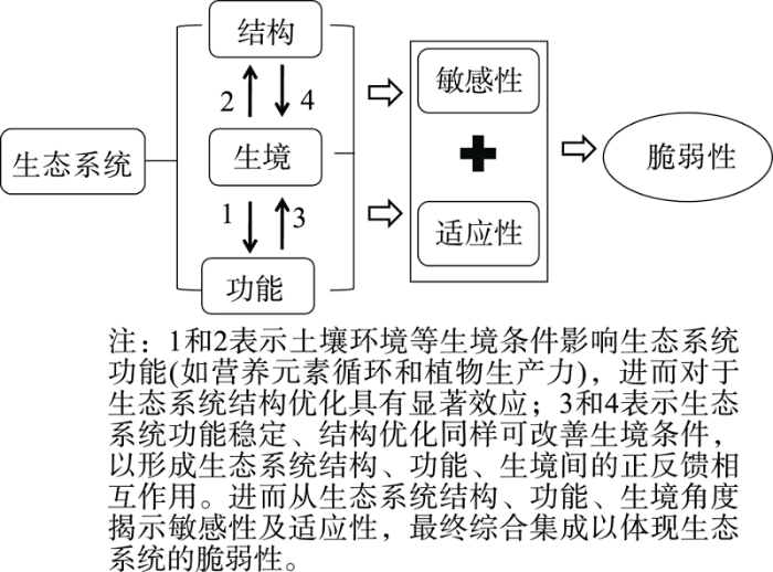