李鹏 , 封志明
, 封志明
中国科学院地理科学与资源研究所,北京 100101
LI Peng, FENG Zhiming
通讯作者:
收稿日期: 2015-10-25
接受日期: 2016-01-25
网络出版日期: 2016-03-25
版权声明: 2016 地理科学进展 《地理科学进展》杂志 版权所有
基金资助:
作者简介:
作者简介:李鹏(1984-),男,江西永新人,副研究员,主要从事资源地理与国土资源遥感研究,E-mail: lip@igsnrr.ac.cn。
展开
摘要
20世纪90年代以来,在全球橡胶市场和地缘经济合作机制的影响下,作为中南半岛唯一的内陆国家,老挝正在经历以橡胶林扩展种植为主导的土地覆被/土地利用变化(LCLUC)。橡胶扩展种植不仅对全球最大的橡胶消费国——中国进口天然橡胶至关重要,其引起的LCLUC也对老挝国内农户社会经济和生态环境造成了深刻影响。本文首先总结了老挝橡胶林种植模式、扩展机制和发展潜力,其次回顾了老挝橡胶扩展种植相关研究进展及橡胶林遥感方法研究进展。综述表明:老挝境内橡胶林种植模式、适宜性空间评价、遥感监测、社会经济与生态环境影响评估研究,总体上仍处于起步阶段。迄今,有关老挝全国层面的橡胶林种植和扩展地理分布及时空变化信息仍非常缺乏,同时橡胶林种植与快速扩展对农户生计和自然环境(水土流失、水源涵养和生物多样性等)影响尚缺乏系统研究,这也是未来需要优先关注的研究方向。本文有助于更好地理解老挝橡胶林扩展特征及其社会与环境影响,既可为指导老挝橡胶种植业有序良性发展提供科技支撑,也可为中国海南与云南等省橡胶发展提供借鉴。
关键词:
Abstract
Since the launch of the Greater Mekong Sub-region Economic Cooperation Program in 1992, driven by the global natural rubber market and geoeconomic cooperation mechanisms, Laos, the only land-locked country in mainland Southeast Asia is experiencing rapid land cover and land use change (LCLUC) due to the rapid establishment and expansion of rubber plantations. Rubber production expansion in Laos is of great importance for China, the largest country of rubber consumption globally, and the rubber-related LCLUC also causes dramatic socioeconomic and environmental impacts within Laos. Therefore, it is important to review rubber plantation establishment and expansion and related remote sensing and impacts studies reported during the last two decades. In this study, after briefly introducing the production, expansion mechanism, and development potential of rubber plantations in Laos, we systematically summarized the research progress on remote sensing monitoring and socioeconomic and environmental impacts of rubber plantation expansion. The review shows that existing studies lack of updated spatial information (extent and distribution) on the establishment and expansion of rubber plantations at the national scale. Effects in the socioeconomic (livelihoods) and environmental (soil erosion, water conservation, biodiversity, etc.) systems are not fully understood. These issues are also the research directions in the future. This study may help improve understanding of the characteristics of rubber plantation expansion and related impacts, and provide guidance for a sound development of rubber industry. In addition, it provides important information for rubber plantation development in Hainan and Yunnan Provinces in China.
Keywords:
橡胶树(Hevea brasiliensis)原生长于南美亚马孙河流域(IRSG, 2013)。目前热带地区植胶园广泛栽培的巴西三叶橡胶,是一种旱季落叶乔木(Balsiger et al, 2000)。其生长适宜温度为20~28°C,年降水量为1800~2000 mm,理论生长海拔达600~800 m(赤道地区超过1000 m)(Dararath et al, 2011)。橡胶树生长5~7年即可产胶,树龄在30年左右产胶量明显下降,之后可作为中密度硬木木材(IRSG, 2013)。天然橡胶是一种重要的战略物资,相较于合成橡胶,其在市场价格、性能和环境影响方面均有优势(Hicks et al, 2009; Fox et al, 2013)。国际市场(如中国、美国、印度和日本等)对天然橡胶强劲的需求势头(Hicks et al, 2009; Evans et al, 2011)促使热带地区橡胶非传统种植国家纷纷发展本国橡胶种植业(Baird, 2010)。橡胶传统种植区为赤道附近南北纬10°之间潮湿的热带地区,如泰国—马来半岛、马来西亚和印尼等;而热带其他地区通常被称为橡胶非传统种植区(Li et al, 2012; Fox et al, 2013)。1950年代,橡胶在热带边缘地区(中国海南和云南西双版纳等)的成功培育和推广,在很大程度上增强了世界同纬度地区植胶和开展橡胶跨区域种植的信心(Li et al, 2012)。迄今,天然橡胶种植北界已抵22°N (Li et al, 2012; Fox et al, 2013),这些区域年降水量仅为1500 mm,且有长达5个月的旱季。
目前,全球有40余个国家种植天然橡胶,亚洲是天然橡胶生产和需求最多的地区。根据FAO统计资料,1961-2011年亚洲多年平均种植面积与产量分别占全球的92.1%和92.2%。其中又以东南亚最为集中,同期天然橡胶平均种植面积与产量分别占亚洲的88.5%与86.6%,其次为南亚(印度与斯里兰卡)和东亚(中国)。与此同时,中国已于21世纪初成为世界上天然橡胶最大消费国,其需求量占全球的25% (Hicks et al, 2009)。尽管橡胶种植面积与产量逐年增加,但全球天然橡胶供给已从2004年起出现短缺,且有扩大的趋势(Hicks et al, 2009)。随着全球市场对天然橡胶的刚性需求,世界范围内的橡胶生产规模还将持续扩大(Dararath et al, 2013; Fox et al, 2013)。在此背景下,区域经济一体化进程促使了东南亚各国橡胶的跨境种植和扩展。老挝作为最不发达国家之一,因其具有丰富的土地资源和劳动力,且毗邻全球橡胶最大需求国,自1992年大湄公河次区域经济合作机制(GMS)启动以来,大力吸引外资和外国技术发展本国橡胶种植业。但由于近年来外国公司在老挝境内大规模推广橡胶种植引发了一系列社会和环境问题,老挝橡胶种植进入了一个调控期。基于此,有必要总结与梳理近20余年橡胶种植及相关研究,以便更好地指导老挝未来的橡胶种植业的发展,同时也可为中国实施跨境橡胶种植和天然橡胶进口提供相关参考。
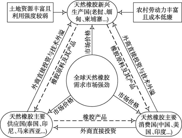
1876年,橡胶树种首次被英国人引入到东南亚(Keong, 1976)。其橡胶种植空间从南向北呈扩展趋势,由南部传统种植国家和地区向北部非传统种植国家和地区蔓延(Baird, 2010; Dong et al, 2013),其中尤以中南半岛最为突出(Fox et al, 2005; Ziegler et al, 2009; Li et al, 2012)。中南半岛具有推广橡胶种植优越的自然生长条件(热量与降水)、丰富的土地资源和劳动力及邻近市场等优势,发展潜力大。有研究预测,到2050年该区域橡胶种植面积将比2001年增加4倍(Ziegler et al, 2009; Fox et al, 2012)。由于橡胶种植是一种资源开发和劳动密集型农业,其投资模式多样,主要由投资国通过提供必要的资金、技术、原材料和市场,被投资国提供土地和劳动力(图1)。老挝与中南半岛其他国家和中国接壤,目前老挝及其毗邻国家橡胶种植业的发展特点主要有以下两方面(Laungaramsri, 2012; Li et al, 2012)。
图1 天然橡胶种植/生产—供应与消费示意图
Fig.1 Schematic diagram of production, supply, and consumption of natural rubber plantation
一是老挝毗邻的主要橡胶生产国(中国、泰国和越南)通过不断调整、扩大本国橡胶种植区域 (Fox et al, 2013),从传统种植区向非传统种植区过渡,呈现出高纬度、高海拔特征。如泰国为当今世界橡胶产量大国(种植面积仅次于印尼),其南部为橡胶传统种植区,近年来为在该区域种植对自然条件要求更高的油棕,转而在其东北部与北部发展橡胶种植业(Hicks et al, 2009)。类似地,越南也逐渐由其南部转向中部、北部、西北部山区,扩大橡胶种植范围(Hicks et al, 2009),并于2012年成为全球第三大天然橡胶生产国。这正好说明了中南半岛比马来群岛在橡胶扩展种植上更具发展潜力。中国境内橡胶适宜种植区利用率已较高(Mann, 2009),可扩大种植区域已十分有限,但仍在积极探索新的种植空间,如西双版纳橡胶种植有向陡坡蔓延趋势 (Qiu, 2009; Liu et al, 2013)。
二是随着东南亚区域经济一体化逐渐深入,中南半岛主要生产国通过合约、合作或承包转让土地等方式逐步在其邻国扩大橡胶生产(Fox et al, 2013)。一系列地缘经济合作机制的启动无疑是区域一体化的重要体现。在GMS(1992)、中老缅泰“黄金四角”经济合作区(1993)、柬老缅越四国合作机制(2000)、柬老泰经济三角区(2003)、柬老泰缅越经济合作机制(2003)、中国—东盟自由贸易区(2010)、澜沧江—湄公河合作机制(2015)和东盟共同体(2015)等地缘经济合作机制的影响下,来自中国、越南、泰国及马来西亚等国的国有/私营企业纷纷涌入中南半岛的老挝、柬埔寨和缅甸投资橡胶生产(Qiu, 2009; Evans et al, 2011)。相比而言,柬埔寨以平原为主,以稻米生产为主导,橡胶种植比重较低,且受越南、泰国影响较大。缅甸土地资源丰富,但国内政治环境不稳定,橡胶种植受到一定限制。老挝是目前中南半岛发展橡胶种植最集中的国家之一,橡胶已成为老挝最重要的出口商品之一。老挝疆域版图南北长而东西窄,是中南半岛唯一的内陆国家(Land-locked),也是中南半岛地理意义上的中心。橡胶跨境种植在地理空间上同时受中国、泰国和越南三国地缘影响,在日益增强的区域合作机制的推动下,老挝逐渐由内陆国转向陆上联系国(Land-linked),使得老挝包括橡胶种植在内的许多合作领域同时受到邻国(特别是中国、泰国与越南)影响。在区域合作机制的影响下,老挝成为了区域扩展橡胶种植的重点合作区域。随着邻国企业逐步进入老挝投资橡胶种植,老挝境内橡胶种植面积近10年来大幅增加,尤其是在老挝北部与南部省份(Hicks et al, 2009; Fox et al, 2013),其中老挝北部以中国投资为主,中部以泰国为主,而南部则以越南为主(Douangsavanh et al, 2008; Evans et al, 2011)。比较而言,通过区域经济一体化途径对橡胶规模扩展影响较大,且对区域经济和生态环境的影响业已引起国际社会和学术界的普遍关注(Cohen, 2009)。
老挝国土面积23.68万km2,2015年人口约680万(United Nations, 2015),人少地多。属热带亚热带季风气候,年均气温约26℃,年降水量1250~3750 mm,5-10月为雨季,11月-次年4月为旱季。境内山地与高原面积占80%,森林覆盖率高。老挝经济以农业为主,工业落后,现正在积极快速融入东南亚区域经济合作。20世纪30年代,橡胶树首次引入老挝并在其南部占巴塞省种植。但直到老挝1986年推行经济改革及GMS(1992年)建立后,橡胶种植才逐渐得到重视。到20世纪90年代中期陆续出现植胶园,但规模不大,21世纪初开始产胶。自2004年起,中国、越南和泰国等外国企业开始大规模在老挝境内投资种植橡胶,橡胶种植扩展迅速(Manivong et al, 2008; Hicks et al, 2009)。老挝希望通过大力发展橡胶种植,到2020年成为重要的天然橡胶出口国(Kokmila et al, 2010)。
目前,老挝橡胶种植模式包括4种类型:农户自主经营、农民协会集体经营、合约经营和土地转让经营(Hicks et al, 2009; Fox et al, 2014a)。其中,前两种由老挝本国农民或公司主导,后两种为外国企业在老挝投资种植方式。农户自主经营在老挝北部非常普遍(Manivong et al, 2008),如琅南塔省农户自主种植橡胶面积占总面积的80%(Shi, 2008)。该模式特征为农户自己出资,橡胶品种、市场和技术等信息来自于他们在中国的亲朋好友。农民协会模式在老挝比重不大,其最显著特征是橡胶销售和价格由协会统一管理。合约模式是中国在老挝投资橡胶种植的主要经营形式,由老挝农民或农户组织提供土地和劳动力,中国投资者提供发展橡胶种植所需的资金、技术并负责市场销售,即“2+3”模式。该模式易转变成“1+4”模式,即老挝方只提供土地或劳动力,其他均由中国投资方主导(Baird, 2010)。合约模式在帮助当地农民增加收入、改善生计和基础设施等方面得到学界的认可(Manivong et al, 2008; Laungaramsri, 2012; 郭继光, 2013)。土地转让模式则是越南在老挝南部植胶的经营形式。该模式由越方投资者通过较低租金长期(40~99年)租借或承包农户土地进行自主经营。由于造成农户失去土地,该模式在老挝南部引起了较大争议(Baird, 2010; Laungaramsri, 2012),特别是引发了严重的社会问题(Laungaramsri, 2012),2012年起老挝政府终止了该模式的土地承包审批,这一决定将持续到2015年底(Land Issues Working Group, 2013)。从地理分布上看,老挝南北植胶模式存在明显差异,农户模式、农户协会模式和契约模式在老挝北部占主导,而土地转让模式在老挝南部非常普遍(Hicks et al, 2009; Laungaramsri, 2012)。
老挝是个多山国家,植胶条件优越,但其植胶历史较晚,快速扩展主要发生在2000年之后 (Douangsavanh et al, 2008)。因此,橡胶林地是老挝一种新的典型土地利用类型。一般地,橡胶树从定植到割胶需要5~7年,特别是定植3~4年内以幼树为主,土地覆被组成类型复杂多样,地物波谱信息不对称,不利于遥感识别。到目前为止,老挝境内近20年有关橡胶林种植时空格局及扩展过程的动态遥感监测研究尚未见报道。基础数据的缺乏制约了后续对橡胶林地扩张的社会经济与生态环境影响的定量评估(Vongvisouk et al, 2014)。然而,由于橡胶林地快速扩展造成的森林面积减少、林地退化和农户生计影响等问题,已引起政府与学界的关注。目前,相关零星研究可概括为橡胶种植适宜性评价、橡胶林地遥感算法构建与信息提取两方面。
近10余年来,全球市场对天然橡胶的旺盛需求导致其价格长期处在高位震荡(Ahrends et al, 2015),同时政府层面还力图通过推广橡胶种植来替代种植罂粟、刀耕火种并改善农户生计(Vongvisouk et al, 2014),因此,橡胶种植得到快速发展。囿于经济利益驱使,事实上很多新配置用于橡胶种植的土地很少开展相关适用性评价(Vongkhamor et al, 2007),或仅仅利用地形因子(如海拔与坡度)来初步界定(Land Management Component, 2005)。为确定老挝境内橡胶适宜的种植范围,运用自然地理因子、经济因子、政策因子和森林覆被数据等资料,基于ArcGIS平台和模糊逻辑分析方法,根据适宜性程度(半定量)进行模糊化处理,分别模拟了无任何保护政策、最大保护政策和按现在发展模式3种情景下老挝橡胶种植的潜在空间分布。结果表明:“无任何保护政策”情形下橡胶适宜种植面积最大,占老挝总面积的20%;“最大保护政策”情形下橡胶适宜种植面积最小,仅占5%;“按现在发展模式”情形下橡胶适宜种植面积介于二者之间(Hurni, 2008)。该研究首次从老挝自然地理、经济发展和相关政策安排等评价了橡胶潜在适宜种植区,对于指导老挝未来橡胶种植发展空间可提供重要参考。然而,由于该研究过多地使用替代数据(如历史文献)或用区域数据来替代全国数据(如仅利用琅南塔省某样区橡胶种植分布的因子属性以推广到全国层面),以及对不同因子权重进行主观赋值等,可能会影响其评价结果的真实性。
3.2.1 橡胶林地遥感监测数据源
从影像可获取性看,已有研究主要是基于MODIS和中高分辨率影像对老挝境内橡胶林监测分区。如利用MODIS/NDVI时间序列数据(250 m)和老挝各省橡胶统计资料(规模和所属区域),通过判别混合像元橡胶种植概率获取橡胶(含幼林与成林)现状分布图(Li et al, 2012),首次从老挝国家层面揭示了全国橡胶种植的空间分布。但是该研究也存在两方面缺陷:一是老挝各省统计资料容易收集外国公司在老境内橡胶种植规模及其空间归属信息,但对于境内异军突起的小农户自主经营种植情况很难掌握。因而,该研究获得的橡胶种植分布图可能遗漏了小农户种植橡胶的空间信息。二是所采用数据的空间分辨率较低(Li et al, 2011a)。MODIS数据具有从全国层面大致掌握橡胶分布格局的潜力,但仍难以回避低空间分辨率引起的混合像元问题,尽管该研究也注意到这方面的问题并采取了相应的处理方法,但效果不佳(Senf et al, 2013)。以小农户自主经营的橡胶种植为例,在种植规模上远小于外国投资公司,且分布不成片,这些都不利于MODIS数据的准确提取。
对于仍处于橡胶林快速扩展的老挝而言,适合同时采取中、高分辨率影像进行橡胶幼林和成林遥感动态监测。然而,动态监测橡胶林地往往受到云层影响而使数据获取受限(Hurni, 2008)。这种情况在东南亚雨季(5-10月)尤其如此,而在旱季由于受东北季风影响,高压带盛行,降雨很少,对光学卫星成像和获取高质量影像非常有利(Li et al, 2014)。以老挝境内轨道号Path/Row 130/046对应的Landsat TM/ETM+/OLI卫星数据为例,2009-2015年间云覆盖量少于10%影像总计有50景,其中旱季(11月-次年4月)高达45景(http://glovis.usgs.gov/,截止日期为2015年12月31日)。值得注意的是,橡胶树在旱季会经历从落叶到新叶萌生的过程,这一物候特征与旱季Landsat成像情况,促使了Landsat历史影像资料在橡胶种植遥感监测中的应用(Li et al, 2015)。事实上,Landsat卫星因其观测较早而最早应用于橡胶林地监测(Sinthurahas et al, 1988; Danskulphol et al, 1990)。上述两种方法由于充分考虑到橡胶林与自然林的生理和物候特征,从而大大降低了对影像数据量的要求(Van Niel et al, 2004)。
3.2.2 橡胶成林的遥感识别与提取
热带地区橡胶成林遥感识别的突破口为充分利用其旱季的落叶和新叶萌生物候特征(Li et al, 2015)。橡胶成林在雨季枝繁叶茂,与热带地区其他常绿植被的光谱反射特征非常相似。通过增强橡胶林与其他地物之间的光谱特征差异进行识别与分类,主要利用不同波段波谱属性重新构建一系列线性或非线性指数或参数,如决策树方法(李亚飞等, 2011; Liu et al, 2013)、Mahalanobis典型性模型和多层感知器神经网络 (Li et al, 2011a, 2011b)。近年来,随着Landsat历史影像的共享使用,发展了以橡胶林旱季落叶期与新叶萌生期为特征时间窗口或基于橡胶树(林)生育期内的物候特征构建时间序列进行分析(Dong et al, 2013; Li et al, 2015)。这方面的研究多见于中国区域的橡胶林监测(Dong et al, 2013; Li et al, 2015),在老挝境内还未见报道。该方法的实现需要预先揭示老挝境内橡胶林种植的物候特征,尤其是否存在落叶和新叶萌生现象时间信息。由于老挝南北相差近10个纬度,该方法的应用需要充分考虑其纬度地带差异。
3.2.3 橡胶幼林的遥感识别与提取
不同林龄(如成林和幼林)橡胶林地光谱特征存在明显差异(Ekadinata et al, 2004)。橡胶幼林冠层覆盖小、郁闭度低,与其他背景地物,如裸地、耕地(含休耕地)及混合灌木地混杂一起,传统像元分类方法已无法满足橡胶幼林的识别与提取精度要求,为此,有关研究强调要改进和拓展橡胶种植的遥感监测方法(Hurni, 2008)。对于高分辨率影像而言,橡胶林地(特别是幼林阶段)明显的“圈层”纹理特征可能清晰地识别出来。因此,根据ALOS、SPOT及Quickbird等影像资料完全可以准确目测勾绘出来(刘洪江等, 2010)。如Hurni(2008)利用2001-2006年两期ASTER影像,运用面向对象的遥感分类方法提取琅南塔省某样区的橡胶种植分布。基于橡胶种植园的纹理特征,面向对象的遥感分类方法逐渐受到关注(Walter, 2004; Blaschke, 2010)。与传统基于像元的分类方法不同,该方法在利用像元光谱属性的基础上,还挖掘了地物之间的空间关系和几何属性(如纹理)等有效信息辅助遥感分类(Hurni, 2008),其分类基本单元不是单个像元,而是属于同一对象地物的邻近像元集(Walter, 2004)。
对橡胶种植监测而言,由于其具备独特的属性特征(如外观形状、颜色和结构等相似)、空间关系(如株距和分布)和几何属性(如山坡种植轮廓)等信息,面向对象的遥感分类方法可作为传统基于像元光谱特征分类方法的替代方法(Ekadinata et al, 2004)。尽管面向对象的遥感分类方法在橡胶种植动态监测中具有较大应用前景,但相比而言,目前该方法在橡胶种植识别研究中还处于较低水平的阶段,相关研究案例特别是对老挝橡胶种植分析还非常有限。由于国际市场对天然橡胶的需求增长及价格攀升,未来相当长时期内新兴橡胶种植国家还将持续扩大橡胶种植范围,预示着将有更多的橡胶幼林需要及时动态监测。
老挝作为中南半岛唯一的内陆国,在地缘经济合作机制的影响下,中国、泰国与越南3个毗邻国家分别在其不同地区发展橡胶跨境种植。当前,老挝橡胶种植模式类型多样且发展迅速,但其相关政策、法规、制度安排等发展仍较滞后(Hicks et al, 2009)。为探索有利于消除贫困和发展经济的有效经营模式,已有研究对比了不同经营模式对区域社会经济影响。本文主要评述中、越两国影响下的老挝上寮与下寮地区橡胶扩展种植的社会经济影响。
老挝上寮地区橡胶种植业的发展主要受中国投资者和跨境亲缘的影响(Manivong et al, 2008; Sturgeon, 2010)。在区域地缘经济合作机制(如GMS)的影响下,老挝积极寻求外国资源(资金、技术和市场)发展本国资源密集型、劳动密集型经济。老挝北部毗邻全球橡胶需求最大进口国——中国,加之中国实施通过替代罂粟种植推动海外投资战略(Cohen, 2009),在当前国际橡胶价格形势下,中国与老挝在其上寮地区的橡胶合作种植前景很好。研究表明,老挝北部农户自主经营模式利润较高,对改善民生和发展当地经济起到了促进作用(Manivong et al, 2008; Luangmany et al, 2013),且较合约种植模式或直接雇工参与橡胶种植对改善农户生计作用更为明显(Khamphone et al, 2011)。在合约经营模式下,老挝北部农民并没有变更其土地所有者的身份,对土地使用仍拥有决策权。然而,也有学者认为老挝上寮地区的橡胶种植热潮,反映了中国与西方国家在毒品替代种植发展思路上的冲突,因此担忧西方社会的毒品替代发展将逐渐被中国海外经济战略和投资主导的禁毒政策所冲淡、甚至被边缘化(Cohen, 2009)。
相比之下,老挝下寮地区橡胶种植业发展主要受到越南投资公司的影响(Kenney-Lazar, 2012; Laungaramsri, 2012)。目前,越南是中南半岛经济发展最快的国家,2012年起,其橡胶出口量取代马来西亚跃居世界第三位,其中60%出口中国,内销约40%。在地缘经济合作机制的推动下,市场需求与价格无疑是越南在老挝推动橡胶跨境种植的动力。老挝下寮地区土地转让经营模式下的农户与土地关系就截然不同。该模式对地区社会经济的影响主要表现为:土地出租造成部分农民丧失土地(耕地、林地与草地)使用权以及相关产品、服务和资源,改变了农民与土地的依存关系(Baird, 2010; Kenney-Lazar, 2012)。客观而言,老挝发展橡胶种植在一定程度上能帮助农户增加收入并带动经济发展,但也造成了其他社会经济影响,如老挝北部山区农户由生计型农业向商品种植过渡引起的粮食安全问题(Luangmany et al, 2013)、南部地区农户被迫放弃世代赖以生存的土地(Baird, 2010; Laungaramsri, 2012)、土地私有化加剧 (Thongmanivong et al, 2006)、经济收入单一和过度依赖性(Hurni, 2008)、农户发展不平衡(Evans et al, 2011) 和未来劳动力严重缺乏(Hicks et al, 2009)等问题。
橡胶林地扩展种植引起的生态环境影响,已在中南半岛其他地区进行了较为深入的研究(Fox et al, 2014b),其中尤以西双版纳地区较多,具体为对水文循环问题(Mann, 2009; Tan et al, 2011)、土壤有机碳下降(De Blécourt et al, 2014)和生物多样性减少问题(Li et al, 2007)等。老挝在扩大橡胶种植范围的同时,必然会对生态环境构成一系列负面影响。2000年以来,针对外国投资公司在老橡胶跨境种植,由湄公河可持续研究网络发布了一份研究报告(Hicks et al, 2009)。该报告将其造成的环境影响概括为4个方面:林木砍伐引起的森林面积减少、生物多样性减少、水源调节和水质净化功能减弱、以及土壤质量下降等(Hicks et al, 2009)。如老挝北部橡胶种植扩展造成了大面积土地利用转换,旱地和休耕林地改种橡胶,从而造成森林面积减少和土壤质量下降(如有机质流失等)(Luangmany et al, 2013)。该报告还指出,根据老挝环境保护法,所有在老挝境内投资橡胶种植的公司都被强制要求开展环境影响评估,但在实际运营中执行情况却不容乐观(Shi, 2008; Hicks et al, 2009)。相对于社会经济影响而言,橡胶林扩展种植引起的生态环境变化具有明显的滞后效应,但目前有关老挝橡胶扩展种植对生态环境(特别是对生物多样性)影响的实际评估研究已逐渐受到学界重视。老挝森林覆盖率高,且属于REDD+行动计划合作伙伴国家,橡胶林地扩展种植引起的森林面积减少与林地退化、生物多样性减少等问题,也开始受到地方政府的关注。
在当前全球橡胶生产和发展形势下,老挝为发展替代罂粟种植和根除刀耕火种,促使其从中南半岛内陆国变为区域陆上联系国,橡胶种植经历了快速但无序的发展。综述表明,尽管部分研究对老挝境内橡胶林种植模式、适宜性空间评价、遥感监测、社会经济与生态环境影响评估开展了初步的分析,但总体上研究仍处于起步阶段。首先,有关老挝全国层面的橡胶林种植、扩展地理分布及时空变化信息仍非常缺乏;其次,橡胶林种植与快速扩展对农户生计和自然环境(水土流失、水源涵养和生物多样性等)影响缺乏系统研究。未来需要加强的研究领域有:①结合老挝橡胶林生长物候特征、空间关系和几何特征,发展和改进橡胶幼林、成林的遥感监测算法,揭示老挝近30年(尤其是2000年以后)的橡胶种植和橡胶林扩展的格局变化;②评估橡胶种植与自然地理(如地表、气温、降水和土壤属性等)、人类活动(如居民点和道路网络等)和政策、制度安排等要素之间的相互关系,在此基础上构建橡胶适应性空间评价模型并对全国橡胶种植适宜性进行评价,促进未来橡胶种植业有序发展;③从农户与社区层面,评估老挝上、中、下寮地区不同橡胶种植模式对农户生计的影响,同时加强地方尺度上的水文涵养监测和水土流失过程研究,模拟橡胶扩展种植引起的碳排放变化。
由于政府层面缺乏对外国企业在当地进行橡胶投资的有效引导和监管,目前不仅有关橡胶种植的空间分布、时空扩展等资料还非常匮乏(Hicks et al, 2009),而且对不同地区(上、中、下寮)不同橡胶种植投资模式下的扩展强度和地域特征也缺乏认识。未来可以在遥感监测、社会经济与生态环境影响评估方面优先开展研究。
首先,橡胶种植基础地理信息是开展其他各项研究的前提,充分掌握老挝橡胶种植分布格局动态信息,有助于中国从战略层面制定天然橡胶进口政策。相对于中国天然橡胶总进口量而言,老挝天然橡胶年总产量还不大,但已成为老挝出口中国的第四大产品。由于邻近中国市场且老挝北部为中国境外橡胶投资集中地区,及时掌握其空间分布及扩展信息对扩大再生产和制定橡胶种植相关政策非常重要。目前,中国、越南和泰国在老挝的投资规模资料(如合约种植与土地转让的规模大小和权属信息等)可以及时掌握,但其空间分布格局及动态变化特征则是未来遥感监测需要加强的研究方向。此外,还需要加强对其他方式(如民间投资)橡胶种植信息的调查与获取(Hurni, 2008)。近年来,受中国橡胶种植影响和市场的吸引,老挝北部山区的小农户橡胶种植扩展较快(Sturgeon, 2013)。农户自主经营橡胶种植已成为老挝橡胶种植不可忽视的一部分。
其次,需要评估橡胶不同种植模式对当地社会经济的积极与消极影响。在老挝,政府部门把橡胶种植视为根除刀耕火种农业的替代发展,是发展罂粟替代种植的优先经济作物。不同地区引入了不同的橡胶种植模式,在增加当地农户收入、增加就业机会和改善基础设施条件方面产生了积极的作用,但也在森林砍伐、耕地征用和粮食安全等方面造成一些负面影响。及时掌握不同种植模式下的橡胶种植数据,可以对比研究不同种植模式的优劣程度,探索符合老挝国情的橡胶种植模式。
最后,需要评估橡胶种植扩展对区域生态环境(水循环、碳汇和生物多样性等)的影响。近20年来,橡胶种植在中南半岛各国扩展非常迅速(Fox et al, 2005; Li et al, 2012),已成为许多国家最重要的出口商品之一。在中南半岛山区,以橡胶为代表的人工林种植正逐渐替代传统生计型农业(刀耕火种农业)和毒品(罂粟)种植,已成为引起森林(包括天然林和次生林)大面积砍伐的主要原因之一(Ziegler et al, 2009)。由森林向单一橡胶作物种植转换将对区域生物多样性构成威胁(Li et al, 2007),同时还影响到碳汇(Li et al, 2008; Qiu, 2009)。这种土地利用转变还可能对区域水循环造成负面影响(Mann, 2009; Tan et al, 2011)。但到目前为止,橡胶种植基础地理数据仍然相对缺乏,这对评估橡胶种植引起的环境影响至关重要(Ziegler et al, 2009)。
在当前发展形势下,老挝对发展橡胶种植的重视及其良好的投资环境,推动了老挝全国发展橡胶种植业的高潮(Rubber Boom);同时,老挝丰富的土地资源和劳动力、以及国际市场对天然橡胶的旺盛需求,进一步拉动了老挝橡胶的扩大再生产。未来一段时期内,如果照近年的发展趋势,这种显著的推拉作用将促使老挝境内土地利用和土地覆被发生巨大的变化,更多的森林和耕地将为单一的橡胶种植园所取代。可以预见,这种变化将对老挝未来的社会、经济、生态和环境等造成深刻的影响,其对生态环境负反馈也将波及全世界,这也正是国际社会和学术界所忧虑的。近年来,国际组织一直致力于推动老挝及整个中南半岛的森林管理与生物多样性保护等研究,其中最重要的当属联合国提出的REDD+行动计划。因此,及时、准确识别和监测老挝橡胶种植的时空格局及其空间扩展趋势,对定量评估其对生态环境和社会经济影响具有重大意义(Li et al, 2012; Senf et al, 2013)。
The authors have declared that no competing interests exist.
| [1] |
中国企业对老挝的直接投资及其影响 [J].https://doi.org/10.3969/j.issn.1008-6099.2013.05.005 URL [本文引用: 1] 摘要
近年来,中国企业对老挝的直接投资呈加速发展态势,投资流量及存 量的增长都在提速,已经成为老挝最重要的外资来源国之一.中国企业对老挝的直接投资在一定程度上促进了当地经济和社会的快速发展:提供了老挝经济发展所需 要的资金;改善了老挝的基础设施;提升了老百姓的生活水平.但是,中国企业在老挝的投资也存在一些问题:投资的行业有些过于集中在资源领域;少数在老挝投 资的中国企业或者个人存在着非法经营和非法用工现象;普遍缺乏与媒体的沟通能力和意愿.
The direct investment of Chinese enterprises in Lao PDR and its impact [J].https://doi.org/10.3969/j.issn.1008-6099.2013.05.005 URL [本文引用: 1] 摘要
近年来,中国企业对老挝的直接投资呈加速发展态势,投资流量及存 量的增长都在提速,已经成为老挝最重要的外资来源国之一.中国企业对老挝的直接投资在一定程度上促进了当地经济和社会的快速发展:提供了老挝经济发展所需 要的资金;改善了老挝的基础设施;提升了老百姓的生活水平.但是,中国企业在老挝的投资也存在一些问题:投资的行业有些过于集中在资源领域;少数在老挝投 资的中国企业或者个人存在着非法经营和非法用工现象;普遍缺乏与媒体的沟通能力和意愿.
|
| [2] |
基于 HJ-1 CCD 数据的西双版纳地区橡胶林分布特征 [J].
文中以我国HJ-1卫星为主要 遥感数据源,结合野外采样数据,采用决策树的监督分类方法,获取云南省西双版纳地区2011年的橡胶林分布状况,并在此基础上,以覆盖该区域的数字高程模 型(DEM)和气象数据为基础,利用地理信息系统(GIS)空间分析方法,着重量化分析西双版纳地区橡胶林分布的气候特征和地形特征,得出西双版纳地区橡 胶林的气候边界,界定橡胶林分布的海拔、坡度以及坡向范围.文中得到以下结论:利用环境一号卫星遥感数据能够获得精确的分类信息,表明环境一号卫星遥感影 像能够作为获取植被环境信息的可靠数据源,实现重点植被生态问题的动态监测;橡胶林分布的高程上限是2100m,80%的橡胶林分布在高程范围为 600-1300m的范围内,90%的橡胶林分布在坡度为0?到24?的范围内,橡胶林分布对坡向不敏感;橡胶林适宜分布在平均气温大于18?C,平均最 高气温大于25?C,平均最低气温大于14?C的区域,这些区域的橡胶林分布比率较大.研究还定量分析了西双版纳橡胶林空间分布的地形和气候幅度,为橡胶 林种植业的健康发展提供科学支撑.
Analysis of distribution characteristics of Hevea brasiliensis in the Xishuangbanna area based on HJ-1 satellite data [J].
文中以我国HJ-1卫星为主要 遥感数据源,结合野外采样数据,采用决策树的监督分类方法,获取云南省西双版纳地区2011年的橡胶林分布状况,并在此基础上,以覆盖该区域的数字高程模 型(DEM)和气象数据为基础,利用地理信息系统(GIS)空间分析方法,着重量化分析西双版纳地区橡胶林分布的气候特征和地形特征,得出西双版纳地区橡 胶林的气候边界,界定橡胶林分布的海拔、坡度以及坡向范围.文中得到以下结论:利用环境一号卫星遥感数据能够获得精确的分类信息,表明环境一号卫星遥感影 像能够作为获取植被环境信息的可靠数据源,实现重点植被生态问题的动态监测;橡胶林分布的高程上限是2100m,80%的橡胶林分布在高程范围为 600-1300m的范围内,90%的橡胶林分布在坡度为0?到24?的范围内,橡胶林分布对坡向不敏感;橡胶林适宜分布在平均气温大于18?C,平均最 高气温大于25?C,平均最低气温大于14?C的区域,这些区域的橡胶林分布比率较大.研究还定量分析了西双版纳橡胶林空间分布的地形和气候幅度,为橡胶 林种植业的健康发展提供科学支撑.
|
| [3] |
老挝北部罂粟替代种植高分辨率遥感调查评价与分析 [J].
替代种植是一惠及地区、国际及中国三方的可持续型的禁毒措施,可以从源头上对罂粟毒品进行铲除。我国许多企业已经在金三角地区开展罂粟替代种植项目。本文采用ALOS、SPOT及快鸟卫星结合地形图对坡勾绘法进行老北罂粟替代种植核实,根据核查结果推算,2006年在老挝北部区域分布中国各地类替代种植地块面积为10.8万hm2,种植面积最大的依次为橡胶64.0%,粮食23.9%,甘蔗9.9%。种植企业的空间分布主要沿公路沿线交通便利地区,老挝南部省区基本为橡胶,临近中国的省区为橡胶为主的粮食间种结构。结果表明我国资源经济逐渐向外向型转变,种植企业多以云南省地方型小企业为主,缺少应对国际经济经营的理念和风险经营策略,应从国家层面上对种植企业予以扶持,降低企业面临的风险,加强替代种植的可持续性。
Evaluation and analysis for the substitution planting for opium poppy in the north of Laos based on remote sensing [J].
替代种植是一惠及地区、国际及中国三方的可持续型的禁毒措施,可以从源头上对罂粟毒品进行铲除。我国许多企业已经在金三角地区开展罂粟替代种植项目。本文采用ALOS、SPOT及快鸟卫星结合地形图对坡勾绘法进行老北罂粟替代种植核实,根据核查结果推算,2006年在老挝北部区域分布中国各地类替代种植地块面积为10.8万hm2,种植面积最大的依次为橡胶64.0%,粮食23.9%,甘蔗9.9%。种植企业的空间分布主要沿公路沿线交通便利地区,老挝南部省区基本为橡胶,临近中国的省区为橡胶为主的粮食间种结构。结果表明我国资源经济逐渐向外向型转变,种植企业多以云南省地方型小企业为主,缺少应对国际经济经营的理念和风险经营策略,应从国家层面上对种植企业予以扶持,降低企业面临的风险,加强替代种植的可持续性。
|
| [4] |
Current trends of rubber plantation expansion may threaten biodiversity and livelihoods [J].https://doi.org/10.1016/j.gloenvcha.2015.06.002 URL [本文引用: 1] 摘要
The first decade of the new millennium saw a boom in rubber prices. This led to rapid and widespread land conversion to monoculture rubber plantations in continental SE Asia, where natural rubber production has increased >50% since 2000. Here, we analyze the subsequent spread of rubber between 2005 and 2010 in combination with environmental data and reports on rubber plantation performance. We show that rubber has been planted into increasingly sub-optimal environments. Currently, 72% of plantation area is in environmentally marginal zones where reduced yields are likely. An estimated 57% of the area is susceptible to insufficient water availability, erosion, frost, or wind damage, all of which may make long-term rubber production unsustainable. In 2013 typhoons destroyed plantations worth US$ >250 million in Vietnam alone, and future climate change is likely to lead to a net exacerbation of environmental marginality for both current and predicted future rubber plantation area. New rubber plantations are also frequently placed on lands that are important for biodiversity conservation and ecological functions. For example, between 2005 and 2010 >2500 kmof natural tree cover and 610 kmof protected areas were converted to plantations. Overall, expansion into marginal areas creates potential for loss-loss scenarios: clearing of high-biodiversity value land for economically unsustainable plantations that are poorly adapted to local conditions and alter landscape functions (e.g. hydrology, erosion) – ultimately compromising livelihoods, particularly when rubber prices fall.
|
| [5] |
Land, rubber and people: Rapid agrarian changes and responses in southern Laos [J].
Abstract In recent years Laos has experienced rapid changes in land and resource use and tenure. Of those, the allocation of expansive land concessions for rubber production has been amongst the most significant. While rubber is being developed in various ways in
|
| [6] |
The utilization, processing and demand for rubberwood as a source of wood supply [R]. |
| [7] |
Object based image analysis for remote sensing [J].https://doi.org/10.1016/j.isprsjprs.2009.06.004 Magsci [本文引用: 1] 摘要
<h2 class="secHeading" id="section_abstract">Abstract</h2><p id="">Remote sensing imagery needs to be converted into tangible information which can be utilised in conjunction with other data sets, often within widely used Geographic Information Systems (GIS). As long as pixel sizes remained typically coarser than, or at the best, similar in size to the objects of interest, emphasis was placed on per-pixel analysis, or even sub-pixel analysis for this conversion, but with increasing spatial resolutions alternative paths have been followed, aimed at deriving objects that are made up of several pixels. This paper gives an overview of the development of object based methods, which aim to delineate readily usable objects from imagery while at the same time combining image processing and GIS functionalities in order to utilize spectral and contextual information in an integrative way. The most common approach used for building objects is image segmentation, which dates back to the 1970s. Around the year 2000 GIS and image processing started to grow together rapidly through object based image analysis (OBIA - or GEOBIA for geospatial object based image analysis). In contrast to typical Landsat resolutions, high resolution images support several scales within their images. Through a comprehensive literature review several thousand abstracts have been screened, and more than 820 OBIA-related articles comprising 145 journal papers, 84 book chapters and nearly 600 conference papers, are analysed in detail. It becomes evident that the first years of the OBIA/GEOBIA developments were characterised by the dominance of ‘grey’ literature, but that the number of peer-reviewed journal articles has increased sharply over the last four to five years. The pixel paradigm is beginning to show cracks and the OBIA methods are making considerable progress towards a spatially explicit information extraction workflow, such as is required for spatial planning as well as for many monitoring programmes.</p>
|
| [8] |
The post-opium scenario and rubber in northern Laos: Alternative Western and Chinese models of development [J].https://doi.org/10.1016/j.drugpo.2008.12.005 Magsci [本文引用: 3] 摘要
<h2 class="secHeading" id="section_abstract">Abstract</h2><h4 id="absSec_N5d2825b8N1fb68890">Background</h4><p id="">In the past few years rubber planting has spread rapidly throughout northern Laos, especially in Luang Namtha province that borders China. The impetus for this boom has come partly from the spiralling demand for rubber in China (now the world's largest rubber consumer), the high world prices for rubber, and China's promotion of overseas investment through its opium-replacement policy. These economic factors have converged with the desperate need of impoverished highlanders in northern Laos to replace opium as a cash crop as a consequence of a recent opium-eradication campaign and inadequate alternative development.</p><h4 id="absSec_N5d2825b8N1fb688f0">Methods</h4><p id="">This paper draws upon ethnographic and agro-economic research in northern Laos and neighbouring regions and reports of international development organisations operating in Laos.</p><h4 id="absSec_N5d2825b8N1fb68950">Results</h4><p id="">The rubber boom in northern Laos represents a fundamental clash between Western drug-oriented alternative development, on the one hand, and China's national economic strategies abroad and investment-led narcotics policy, on the other.</p><h4 id="absSec_N5d2825b8N1fb689b0">Conclusion</h4><p id="">China's opium-replacement policy has contributed to a type of unregulated frontier capitalism with socio-economic and environmental effects that threaten the principles and goals of alternative development and even to marginalise the role international development organisations in northern Laos.</p>
|
| [9] |
Use of Landsat TM data to estimate rubber growing area of Thailand [C]// |
| [10] |
Rubber plantation development in Cambodia: At what cost[R]. Penang, |
| [11] |
Soil redistribution by terracing alleviates soil organic carbon losses caused by forest conversion to rubber plantation [J].https://doi.org/10.1016/j.foreco.2013.10.043 URL [本文引用: 1] 摘要
At the cut section of the terrace, topsoil removal caused a depletion of SOC stocks in the youngest plantation followed by SOC stock recovery in the two oldest plantations. The recovery of SOC stocks at the cut section in the two oldest plantations was attributed to the capacity of the exposed subsurface soil to store new organic carbon inputs from roots and litter, and to sedimentation of eroded topsoil materials from the upper slope. At the fill section of the terrace, soil deposition resulted in higher total SOC stocks compared to the reference position in all plantations. This was due to the deposition of redistributed soil material on top of the original soil surface combined with the partial preservation of carbon in the buried soil. Overall, the increase of SOC in the exposed subsurface soil at the cut sections, and the partial preservation of SOC in the buried soil at the fill sections resulted in higher SOC stocks down to 1.2m at the terraces compared to the reference positions in the two oldest plantations. Our results imply that terracing may alleviate SOC losses caused by the conversion of secondary forest to terraced rubber plantation.
|
| [12] |
Mapping deciduous rubber plantations through integration of PALSAR and multi-temporal Landsat imagery [J].https://doi.org/10.1016/j.rse.2013.03.014 URL Magsci [本文引用: 3] 摘要
Due to increasing global demand for natural rubber products, rubber (Hevea brasiliensis) plantation expansion has occurred in many regions where it was originally considered unsuitable. However, accurate maps of rubber plantations are not available, which substantially constrain our understanding of the environmental and socioeconomic impacts of rubber plantation expansion. In this study we developed a simple algorithm for accurate mapping of rubber plantations in northern tropical regions, by combining a forest map derived from microwave data and unique phenological characteristics of rubber trees observed from multi-temporal Landsat imagery. Phenology of rubber trees and natural evergreen forests in Hainan Island, China, was evaluated using eighteen Landsat TM/ETM+ images between 2007 and 2012. Temporal profiles of the Normalized Difference Vegetation Index (NDVI), Enhanced Vegetation Index (EVI), Land Surface Water Index (LSWI), and near-infrared (NIR) reflectance for rubber trees and natural forest were constructed. The results showed that rubber plantations are distinguishable from natural evergreen forests in two phenological phases: 1) during the defoliation (leaf-off) phase in late February-March, vegetation index (NDVI, EVI, LSWI) values were lower in rubber plantations than in natural evergreen forests; and 2) during the foliation (new leaf emergence) phase in late March-April, rubber plantations had similar NDVI and LSWI values but higher EVI and NIR reflectance values than in natural forests. Therefore, it is possible to delineate rubber plantations within forested landscapes using one to two optical images acquired in the defoliation and/or foliation period. The mapping technique was developed and applied in the Danzhou Region of Hainan. Phased Array type L-band Synthetic Aperture Radar (PALSAR) 50-m Orthorectified Mosaic images were used to generate a forest cover map and further integrated with the phenological information of rubber plantations extracted from Landsat TM images during the foliation phase. The resultant map of rubber plantations has high accuracy (both producer's and user's accuracy is 96%). This simple and integrated algorithm has the potential to improve mapping of rubber plantations at the regional scale. This study also shows the value of time series Landsat images and emphasizes imagery selection at appropriate phenological phase for land cover classification, especially for delineating deciduous vegetation. (C) 2013 Elsevier Inc. All rights reserved.
|
| [13] |
Meeting regional and global demands for rubber: A key to proverty alleviation in Lao PDR[R]. Bangkok, |
| [14] |
Rubber agroforest identification using object-based classification in Bungo District, Jambi, Indonesia [C]// |
| [15] |
An agent-based model of agricultural innovation, land-cover change and household inequality: The transition from swidden cultivation to rubber plantations in Laos PDR [J].https://doi.org/10.1080/1747423X.2011.558602 URL [本文引用: 4] 摘要
This article examines the transition from shifting cultivation to rubber production for a study area in northern Laos PDR using an agent-based model of land-cover change. A primary objective of the model was to assess changes in household-level inequality with the transition from shifting cultivation to rubber adoption. A secondary objective was to develop explanations for the rate of rubber adoption in the study area. We fit the model to historical land-cover data and land use histories developed from household-level field interviews to reproduce the land use decisions of smallholders over time. The model results indicate an increase in household inequality over time as a function of the variable rate of rubber adoption over time.
|
| [16] |
Expansion of rubber (Hevea brasiliensis) in Mainland Southeast Asia: What are the prospects for smallholders [J].https://doi.org/10.1080/03066150.2012.750605 URL [本文引用: 7] 摘要
The rubber tree is native to the humid tropics and has traditionally been cropped in the equatorial zone between 10°N and 10°S; in mainland Southeast Asia this includes portions of southern Thailand, southeastern Vietnam, and southern Myanmar. In the early 1950s, the Chinese government began to invest in growing rubber in environments perceived to be ecologically marginal and eventually established state rubber plantations in areas that lie as far north as 22° north latitude. China's success in growing rubber in these ‘non-traditional’ environments expanded the habitat in which rubber could be planted and pushed it further north. Today entrepreneurs from China, Vietnam, Malaysia, and Thailand are investing in rubber plantations in areas of Laos, Cambodia, and Myanmar, northwest Vietnam, northeast Thailand, and Yunnan, China. The impact of rubber on smallholders, however, is not yet clear. Experiences in Xishuangbanna, Yunnan, China and northeast Thailand clearly show that smallholder rubber production is a viable and effective proposition in moving households and communities out of poverty. By contrast in countries such as Laos, Cambodia and Myanmar many farmers are struggling to maintain their lands and forests in the face of growing pressures from investors and government institutions to impose concession arrangements.
|
| [17] |
a. Swidden, rubber and carbon: Can REDD+ work for people and the environment in Montane Mainland Southeast Asia [J].https://doi.org/10.1016/j.gloenvcha.2013.05.011 URL [本文引用: 1] 摘要
Swidden (also called shifting cultivation) has long been the dominant farming system in Montane Mainland Southeast Asia (MMSEA). Today the ecological bounty of this region is threatened by the expansion of settled agriculture, including the proliferation of rubber plantations. In the current conception of REDD+, landscapes involving swidden qualify almost automatically for replacement by other land-use systems because swiddens are perceived to be degraded and inefficient with regard to carbon sequestration. However, swiddening in some cases may be carbon-neutral or even carbon positive, compared with some other types of land-use systems. In this paper we describe how agricultural policies and institutions have affected land use in the region over the last several decades and the impact these policies have had on the livelihoods of swiddeners and other smallholders. We also explore whether incentivizing transitions away from swiddening to the cultivation of rubber will directly or reliably produce carbon gains. We argue that because government policies affect how land is used, they also influence carbon emissions, farmer livelihoods, environmental services, and a host of other variables. A deeper and more systematic analysis of the multiple consequences of these policies is consequently necessary for the design of successful REDD+ policies in MMSEA, and other areas of the developing world. REDD+ policies should be structured not so much to ‘hold the forest boundary’ but to influence the types of land-use changes that are occurring so that they support both sustainable livelihoods and environmental services, including (but not limited to) carbon.
|
| [18] |
Rubber plantations expand in mountainous Southeast Asia: What are the consequences for the environment [R]. |
| [19] |
Land-use and land-cover change in Montane Mainland Southeast Asia [J].https://doi.org/10.1007/s00267-003-0288-7 Magsci [本文引用: 2] 摘要
<a name="Abs1"></a>This paper summarizes land-cover and land-use change at eight sites in Thailand, Yunnan (China), Vietnam, Cambodia, and Laos over the last 50 years. Project methodology included incorporating information collected from a combination of semiformal, key informant, and formal household interviews with the development of spatial databases based on aerial photographs, satellite images, topographic maps, and GPS data. Results suggest that land use (e.g. swidden cultivation) and land cover (e.g. secondary vegetation) have remained stable and the minor amount of land-use change that has occurred has been a change from swidden to monocultural cash crops. Results suggest that two forces will increasingly determine land-use systems in this region. First, national land tenure policies—the nationalization of forest lands and efforts to increase control over upland resources by central governments—will provide a push factor making it increasingly difficult for farmers to maintain their traditional swidden land-use practices. Second, market pressures—the commercialization of subsistence resources and the substitution of commercial crops for subsistence crops—will provide a pull factor encouraging farmers to engage in new and different forms of commercial agriculture. These results appear to be robust as they come from eight studies conducted over the last decade. But important questions remain in terms of what research protocols are needed, if any, when linking social science data with remotely sensed data for understanding human-environment interactions.
|
| [20] |
Simulating land-cover change in Montane Mainland Southeast Asia [J].https://doi.org/10.1007/s00267-012-9828-3 Magsci [本文引用: 1] 摘要
Abstract<br/>We used the conversion of land use and its effects (CLUE-s) model to simulate scenarios of land-cover change in Montane mainland southeast Asia (MMSEA), a region in the midst of transformation due to rapid intensification of agriculture and expansion of regional trade markets. Simulated changes affected approximately 10 % of the MMSEA landscape between 2001 and 2025 and 16 % between 2001 and 2050. Roughly 9 % of the current vegetation, which consists of native species of trees, shrubs, and grasses, is projected to be replaced by tree plantations, tea, and other evergreen shrubs during the 50 years period. Importantly, 4 % of this transition is expected to be due to the expansion of rubber (<em class="a-plus-plus">Hevea brasiliensis</em>), a tree plantation crop that may have important implications for local-to-regional scale hydrology because of its potentially high water consumption in the dry season.<br/>
|
| [21] |
Rubber investments and market linkages in Lao PDR: Approaches for sustainability[R]. Bangkok, |
| [22] |
Rubber in Laos: Detection of actual and assessment of potential plantations in Lao PDR using GIS and remote sensing technologies [D]. |
| [23] |
|
| [24] |
Plantation rubber, land grabbing and social-property transformation in southern Laos [J].https://doi.org/10.1080/03066150.2012.674942 URL [本文引用: 2] 摘要
This paper critically examines theories of accumulation, dispossession and exclusion for analyzing the agrarian transformations that result from contemporary large-scale land acquisitions across the Global South. Building upon Marx's primitive accumulation, Harvey's accumulation by dispossession and Hall .'s , conceptual lenses are developed through which to examine how land grabs transform property and social relationships of resource-based production. I examine the concession of 10,000 hectares by the central government of Laos to a Vietnamese corporation for extracting timber and planting rubber in the southern province of Attapeu. This acquisition has excluded farmers from land and resources that constituted their primary sources of (re)production, reconfigured rural property relations, altered the peasant relationship to land and produced new exploitative forms of wage labor.
|
| [25] |
Western rubber planting enterprise in Southeast Asia 1876-1921 [M]. |
| [26] |
Effectiveness of rubber plantation on Villagers' livelihood improvement in the northern part of Laos [J].
Rubber plantation processes had been involved with villagers' livelihood improvement as well as poverty reduction in Laos, the rubber plantation had been introduced among Lao farmers in 2000s. This study investigated to examine the effectiveness of rubber planting activities on the poverty criterion that Lao government had focused on the enhancement of local livelihood. 3 villages in Luangnamtha province were selected to investigate their outputs from the rubber plantation such as smallholder planting, contract farming and villagers who had become the employees in the rubber plantation field of investors. Comparison study on the sample households' livelihood in each period (before, during or after rubber plantation) for 3 selected villages, it can be concluded that smallholder planting is evaluated as a rubber planting model with positive impact on their livelihood improvement; and that cases of contract farming and employing of villagers in the rubber plantation field of investors are challenging to their livelihood improvement.
|
| [27] |
Selection of suitable areas for rubber tree (Hevea brasiliensi) plantation using GIS-data in Laos [J]. |
| [28] |
|
| [29] |
|
| [30] |
Frontier capitalism and the expansion of rubber plantations in southern Laos [J]. |
| [31] |
Demand for rubber is causing the loss of high diversity rain forest in SW China [J].https://doi.org/10.1007/s10531-006-9052-7 Magsci [本文引用: 2] 摘要
As the economies of developing countries grow, and the purchasing power of their inhabitants increases, the pressure on the environment and natural resources will continue to increase. In the specific case of China, impressive economic growth during the last decades exemplifies this process. Specifically, we focus on how changing economic dynamics are influencing land-use and land-cover change in Xishuangbanna, China. Xishuangbanna has the richest flora and fauna of China, but increasing demand for natural rubber and the expansion of rubber plantations is threatening this high-diversity region. We quantified land-use/land-cover change across Xishuangbanna using Landsat images from 1976, 1988, and 2003. The most obvious change was the decrease in forest cover and an increase in rubber plantations. In 1976, forests covered approximately 70% of Xishuangbanna, but by 2003 they covered less than 50%. Tropical seasonal rain forest was the forest type most affect by the expansion of rubber plantations, and a total of 139,576 ha was lost. The increase of rubber plantations below 800 m, shifted agricultural activities to higher elevations, which resulted in deforestation of mountain rain forest and subtropical evergreen broadleaf forest. Although these changes have affected the biodiversity and ecosystem services, we believe that long-term planning and monitoring can achieve a balance between economic and social needs of a growing population and the conservation of a highly diverse flora and fauna. Below 800 m , we recommend that no more rubber plantations be established, existing forest fragments should be protected, and riparian forests should be restored to connect fragments. Future rubber plantations should be established in the abandoned arable or shrublands at higher elevations, and tea or other crops should be planted in the understory to improve economic returns and reduce erosion.
|
| [32] |
Past, present and future land-use in Xishuangbanna, China and the implications for carbon dynamics [J].https://doi.org/10.1016/j.foreco.2007.06.051 URL [本文引用: 1] 摘要
Land use/land cover change is an important driver of global change and changes in carbon stocks. Estimating the changes in carbon stocks due to tropical deforestation has been difficult, mainly because of uncertainties in estimating deforestation rates and the biomass in the forest that have been cut. In this study, we combined detailed land-use change over a 27-year period based on satellite images and forest inventory data to estimate changes in biomass carbon stocks in the Xishuangbanna prefecture (1.902million02ha) of China. Xishuangbanna is located in southwestern China in the upper watershed of the Mekong River, and the major forest types are tropical seasonal rain forest, mountain rain forest, and subtropical evergreen broadleaf forest. In the past when the region was completely forested the total biomass carbon would have been approximately 212.6502±028.7502Tg02C. By 1976 forest cover had been reduced to 70%, and in addition many forests had been degraded resulting in a large decrease in the total biomass carbon stocks (86.9702±023.7002Tg02C). From 1976 to 2003, the mean deforestation rate was 13 72202ha02year 611 (1.12%), and this resulted in the loss of 370,49402ha of forest, and by 2003 total biomass carbon stocks had been reduced to 80.8502±022.6402Tg02C. The annual carbon emissions due to land-use change, mainly forest conversion to agriculture and rubber plantations, were 0.3702±020.0302Tg02C02year 611 between 1976 and 1988 and 0.1302±020.0402Tg02C02year 611 between 1988 and 2003. During the next 20 years, if rubber plantations expand into forests outside of reserves, shrublands, grasslands, and shifting cultivation below 150002m the total biomass carbon stocks of Xishuangbanna will decrease to 76.4502±021.4902Tg02C in 2023. This would reflect a loss of 4.1302±021.1402Tg02C between 2003 and 2023, or an annual loss of 0.2102±020.0602Tg02C02year 611 . Alternatively, if rubber plantations only expand into areas of shifting cultivation below 150002m, and all areas presently in shrublands and grasslands are allowed to recover into secondary forests, total biomass carbon stock of the region would increase to 92.6502±023.8002Tg02C in 2023. Under this scenario, the growth of existing forests and the expansion of new forests would result in a net sequestration of 0.6002±020.0602Tg02C02year 611 . This study demonstrates that the uncertainty of biomass estimates can be greatly reduced if detailed land-use analyses are combined with forest inventory data, and that slight changes in future land-use practices can have large implications for carbon fluxes.
|
| [33] |
Cross-comparison of vegetation indices derived from Landsat-7 Enhanced Thematic Mapper Plus (ETM+) and Landsat-8 Operational Land Imager (OLI) sensors [J].https://doi.org/10.3390/rs6010310 URL [本文引用: 1] 摘要
Landsat-7 Enhanced Thematic Mapper Plus (ETM+) and Landsat-8 Operational Land Imager (OLI) and Thermal Infrared Sensor (TIRS) are currently operational for routine Earth observation. There are substantial differences between instruments onboard both satellites. The enhancements achieved with Landsat-8 refer to the scanning technology (replacing of whisk-broom scanners with two separate push-broom OLI and TIRS scanners), an extended number of spectral bands (two additional bands provided) and narrower bandwidths. Therefore, cross-comparative analysis is very necessary for the combined use of multi-decadal Landsat imagery. In this study, 3,311 independent sample points of four major land cover types (primary forest, unplanted cropland, swidden cultivation and water body) were used to compare the spectral bands of ETM+ and OLI. Eight sample plots with different land cover types were manually selected for comparison with the Normalized Difference Vegetation Index (NDVI), the Modified Normalized Difference Water Index (MNDWI), the Land Surface Water Index (LSWI) and the Normalized Burn Ratio (NBR). These indices were calculated with six pairs of ETM+ and OLI cloud-free images, which were acquired over the border area of Myanmar, Laos and Thailand just two days apart, when Landsat-8 achieved operational obit. Comparative results showed that: (1) the average surface reflectance of each band differed slightly, but with a high degree of similarities between both sensors. In comparison with ETM+, the OLI had higher values for the near-infrared band for vegetative land cover types, but lower values for non-vegetative types. The new sensor had lower values for the shortwave infrared (2.11鈥2.29 碌m) band for all land cover types. In addition, it also basically had higher values for the shortwave infrared (1.57鈥1.65 碌m) band for non-water land cover types. (2) The subtle differences of vegetation indices derived from both sensors and their high linear correlation coefficient (R2 > 0.96) demonstrated that ETM+ and OLI imagery can be used as complementary data. (3) LSWI and NBR performed better than NDVI and MNDWI for cross-comparison analysis of satellite sensors, due to the spectral band difference effects.
|
| [34] |
Mapping rubber tree plantations using a Landsat-based phenological algorithm in Xishuangbanna, Southwest China [J]. |
| [35] |
a. Integrating Mahalanobis typicalities with a neural network for rubber distribution mapping [J].https://doi.org/10.1080/01431161.2010.505589 Magsci [本文引用: 2] 摘要
Accurate rubber distribution mapping is critical to the study of its expansion and to provide a better understanding of the consequences of land-cover and land-use change on carbon and water cycles. Employing Mahalanobis typicalities as inputs to a hard classifier to enhance the capability of generalization has not previously been explored. This letter presents a novel approach by integrating Mahalanobis typicalities with the multi-layer perceptron (MLP) neural network for mapping of rubber. A case study from the Thai-Lao and Sino-Lao borders was conducted using Advanced Spaceborne Thermal Emission and Reflection Radiometer (ASTER) data. Different combinations of the nine ASTER bands including Visible and Near Infrared (VNIR) and Short-wave Infrared (SWIR), Normalized Difference Vegetation Index (NDVI) and Mahalanobis typicalities were used as input variables to the MLP. Results indicate that including Mahalanobis typicalities as input variables can improve the MLP's performance and increase the user's accuracy of rubber mapping.
|
| [36] |
b. Rubber tree distribution mapping in Northeast Thailand [J].https://doi.org/10.4236/ijg.2011.24060 URL [本文引用: 1] 摘要
Not Available
|
| [37] |
Mapping rubber tree growth in mainland Southeast Asia using time-series MODIS 250 m NDVI and statistical data [J].https://doi.org/10.1016/j.apgeog.2011.06.018 URL [本文引用: 8] 摘要
Expanding global and regional markets are driving the conversion of traditional subsistence agricultural and occupied non-agricultural lands to commercial-agricultural purposes. In many parts of mainland Southeast Asia rubber plantations are expanding rapidly into areas where the crop was not historically found. Over the last several decades more than one million hectares of land have been converted to rubber trees in areas of China, Laos, Thailand, Vietnam, Cambodia and Myanmar, where rubber trees were not traditionally grown. This expansion of rubber plantations has replaced ecologically important secondary forests and traditionally managed swidden fields and influenced local energy, water and carbon fluxes. Accurate and up-to-date monitoring and mapping of rubber tree growth is critical to understanding the implications of this changing ecosystem. Discriminating rubber trees from second-growth forests and fallow land has proven challenging. Previous experiments using machine-learning approaches with hard classifications on remotely sensed data, when faced with the realities of a heterogeneous plant-life mixture and high intra-class variance, have tended to overestimate the areas of rubber tree growth. Our current research sought to: 1) to investigate the potential of using a Mahalanobis typicality model to deal with mixed pixels; and 2) to explore the potential for combining MOderate Resolution Imaging Spectroradiometer (MODIS) imagery with sub-national statistical data on rubber tree areas to map the distribution of rubber tree growth across this mainland Southeast Asia landscape. Our study used time-series MODIS Terra 16-day composite 250m Normalized Difference Vegetation Index (NDVI) products (MOD13Q1) acquired between March 2009 and May 2010. We used the Mahalanobis typicality method to identify pixels where rubber tree growth had the highest probability of occurring and sub-national statistical data on rubber tree growth to quantify the number of pixels of rubber tree growth mapped per administrative unit. We used Relative Operating Characteristic (ROC) and error matrix analysis, respectively, to assess the viability of Mahalanobis typicalities and to validate classification accuracy. High ROC values, over 0.8, were achieved with the Mahalanobis typicality images of both mature and young rubber trees. The proposed method greatly reduced the commission errors for the two types of rubber tree growth to 1.9% and 2.8%, respectively (corresponding to user鈥檚 accuracies of 98.1% and 97.2%, respectively). Results indicate that integrating Mahalanobis typicalities with MODIS time-series NDVI data and sub-national statistics can successfully overcome the earlier overestimation problem.
|
| [38] |
Rubber plantation and its relationship with topographical factors in the border region of China, Laos and Myanmar [J].https://doi.org/10.1007/s11442-013-1060-4 Magsci [本文引用: 2] 摘要
Abstract<br/><p class="a-plus-plus">Rubber plantation is the major land use type in Southeast Asia. Monitoring the spatial-temporal pattern of rubber plantation is significant for regional land resource development, eco-environmental protection, and maintaining border security. With remote sensing technologies, we analyzed the rubber distribution pattern and spatial-temporal dynamic; with GIS and a newly proposed index of Planted Intensity (PI), we further quantified the impacts and limits of topographical factors on rubber plantation in the border region of China, Laos and Myanmar (BRCLM) between 1980 and 2010. The results showed that: (1) As the dominant land use type in this border region, the acreage of rubber plantation was 6014 km<sup class="a-plus-plus">2</sup> in 2010, accounting for 8.17% of the total area. Viewing from the rubber plantation structure, the ratio of mature- (≥10 year) and young rubber plantation (<10 year) was 5:7. (2) From 1980 to 2010, rubber plantation expanded significantly in BRCLM, from 705 km<sup class="a-plus-plus">2</sup> to 6014 km<sup class="a-plus-plus">2</sup>, nearly nine times. The distribution characteristics of rubber plantation varied from concentrated toward dispersed, from border inside to outside, and expanded further in all directions with Jinghong City as the center. (3) Restricted by the topographical factors, more than 4/5 proportion of rubber plantation concentrated in the appropriate elevation gradients between 600 and 1000 m, rarely occurred in elevations beyond 1200 m in BRCLM. Nearly 2/3 of rubber plantation concentrated on slopes of 8°–25°, rarely distributed on slopes above 35°. Rubber plantation was primarily distributed in south and east aspects, relatively few in north and west aspects. Rubber planted intensity displayed the similar distribution trend. (4) Comparative studies of rubber plantation in different countries showed that there was a remarkable increase in area at higher elevations and steeper slopes in China, while there were large appropriate topographical gradients for rubber plantation in Laos and Myanmar which benefited China for rubber trans-boundary expansion. (5) Rubber plantation in BRCLM will definitely expend cross borders of China to the territories of Laos and Myanmar, and the continuous expansion in the border region of China will be inevitable.</p><br/>
|
| [39] |
Expansion of rubber tree plantation in northern Laos: Economic and environmental consequences [J].https://doi.org/10.2307/3102747 URL [本文引用: 3] 摘要
Rubber trees have been planted in the Northern Province of Laos since the mid-1990s, with tapping beginning in early 2000s. Consequently, livelihoods in the upland of northern Laos have rapidly moved away from subsistence shifting cultivation to rubber tree plantations. As a result, the total area of rubber tree plantations in Laos has drastically increased from 342 ha in the early 1990s to more than 25,000 ha in 2009. This paper reviews the factors that accelerated that rapid expansion of rubber tree plantation in northern Laos and its economic and environmental consequences and identifies key issues for future studies. The Land and Forest Allocation (LFA) program played a direct role in shaping the rubber landscape in northern Laos, but increased demand for natural rubber from China in response to stagnation of Chinese domestic supply was the most important factor behind the rapid expansion of rubber tree plantations in Northern Laos. Therefore, under current and likely future market conditions, investment in smallholder rubber production in Northern Laos appears financially profitable. However, this study found that the economic gains from rubber tree plantations came with losses in food production, soil quality degradation, and deforestation. Therefore, it is necessary to thoroughly analyze the behaviors of smallholder rubber production in Northern Laos to understand their labor allocation decisions for different livelihood activities, including forest extractions along the tract, to achieve the goal of promoting rubber tree plantations as a key strategy to alleviate poverty and as an instrument to eliminate shifting cultivation to conserve natural forests.
|
| [40] |
Economics of smallholder rubber expansion in northern Laos [J].https://doi.org/10.1007/s10457-008-9136-3 Magsci [本文引用: 5] 摘要
<a name="Abs1"></a>In Northern Laos, as elsewhere in the Southeast Asian uplands, there is an agricultural transition underway from subsistence production based on shifting cultivation to commercial production based on tree crops. In response to demand from China, rubber smallholdings are being established by shifting cultivators in Northern Laos, encouraged by government land-use policy. We examine the bio-economics of smallholder rubber production in an established rubber-growing village and model the likely expansion of smallholder rubber in Northern Laos. Data were obtained from key informants, group interviews, direct observation, and a farm-household survey. Latex yields were estimated using the Bioeconomic Rubber Agroforestry Support System (BRASS). A financial model was developed to estimate the net present value for a representative rubber smallholding. This model was then combined with spatial data in a Geographical Information System (GIS) to predict the likely expansion of rubber based on resource quality and accessibility. Implications are drawn for upland development in the region.
|
| [41] |
Addicted to rubber [J].https://doi.org/10.1126/science.325_564 URL PMID: 19644107 [本文引用: 3] 摘要
Mann CC.
|
| [42] |
Where the rubber meets the garden [J]. |
| [43] |
Mapping rubber plantations and natural forests in Xishuangbanna (Southwest China) using multi-spectral phenological metrics from MODIS time series [J].https://doi.org/10.3390/rs5062795 Magsci [本文引用: 2] 摘要
We developed and evaluated a new approach for mapping rubber plantations and natural forests in one of Southeast Asia's biodiversity hot spots, Xishuangbanna in China. We used a one-year annual time series of Moderate Resolution Imaging Spectroradiometer (MODIS), Enhanced Vegetation Index (EVI) and short-wave infrared (SWIR) reflectance data to develop phenological metrics. These phenological metrics were used to classify rubber plantations and forests with the Random Forest classification algorithm. We evaluated which key phenological characteristics were important to discriminate rubber plantations and natural forests by estimating the influence of each metric on the classification accuracy. As a benchmark, we compared the best classification with a classification based on the full, fitted time series data. Overall classification accuracies derived from EVI and SWIR time series alone were 64.4% and 67.9%, respectively. Combining the phenological metrics from EVI and SWIR time series improved the accuracy to 73.5%. Using the full, smoothed time series data instead of metrics derived from the time series improved the overall accuracy only slightly (1.3%), indicating that the phenological metrics were sufficient to explain the seasonal changes captured by the MODIS time series. The results demonstrate a promising utility of phenological metrics for mapping and monitoring rubber expansion with MODIS.
|
| [44] |
Rubber boom in Luang Namtha: A transnational perspective [R]. |
| [45] |
Mapping of rubber plantation area in Thailand using Landsat imagery [C]// |
| [46] |
Governing minorities and development in Xishuangbanna, China: Akha and Dai rubber farmers as entrepreneurs [J].https://doi.org/10.1016/j.geoforum.2009.10.010 URL [本文引用: 1] 摘要
In Xishuangbanna, southern Yunnan, Akha and Dai farmers, regarded in China as “backward”, passive recipients of state-led development, have been “getting rich” on rubber and expanding rubber cultivation into neighbouring Laos. State cash crop campaigns to raise minority farmers’ incomes inadvertently turned minority farmers into dynamic entrepreneurs. This paper builds on Vinay Gidwani’s use of development as a “regime of value” to raise social and economic value to analyze these unexpected results. Local state agents believe they are the agents of development, bringing modest social and economic improvements to minority farmers of obdurate backwardness. Minority farmers see themselves as improving their own incomes and “quality”, a term in China for social value, in an era when they are responsible for their own development. National development discourse encourages citizens to raise population quality by becoming entrepreneurial, a message heard by minority rubber farmers as well as urban elites. Through creative, post-Fordist production models and agile deployment of land, labour, and capital, minority farmers have achieved incomes that exceed those of workers on state rubber farms, large plantations whose Fordist production models are losing out in the uneven transition from a planned economy to a more capitalist market assemblage. Akha and Dai rubber farmers, the “backward” minorities on China’s periphery, have unexpectedly become the forerunners of flexible production arrangements that are prevailing in the arena opened up by China’s 2001 entry into the World Trade Organization.
|
| [47] |
Cross-border rubber cultivation between China and Laos: Regionalization by Akha and Tai rubber farmers [J].https://doi.org/10.1111/sjtg.12014 URL [本文引用: 1] 摘要
Abstract Top of page Abstract Methods Theoretical considerations Being ‘modern’ in Xishuangbanna State rubber farms – bastions of modernity Minority rubber farmers becoming modern Cross-border history Cross-border rubber cultivation Conclusions Acknowledgements References This paper is a multi-sited ethnography of cross-border rubber cultivation between China and Laos. Smallholder minority rubber farmers from Xishuangbanna (China) have forged successful informal share-cropping arrangements to grow rubber trees on the land of relatives and friends in neighbouring Laos. By becoming rich and entrepreneurial rural citizens, Akha and Tai farmers have also, in their own eyes, raised their own ‘quality’ ( suzhi ) and see themselves as ‘modern’. By examining various meanings of ‘modern’ in China, and contrasting the rubber farmers' experience with Jacob Eyferth's notion of rural ‘deskilling’, this paper shows how through learning to plant, cultivate and tap rubber, these farmers have taken on the discipline and technical knowledge of ‘modern’ workers and become ‘skilled’. By rising in ‘quality’, minority farmers on China's periphery challenge the entrenched binaries of urban/rural, modern/backward, prosperous/poor and Han/minority nationality. Xishuangbanna minority farmers acknowledge that they are also ‘backward’ in the Chinese social hierarchy, but their extension of rubber cultivation to kin and others in Laos has confirmed their modernity as dispensers of development, technical know-how and ‘superior’ Chinese culture to Lao farmers who are ‘backward and poor’. In contrast to large state rubber farms that have failed to establish rubber plantations in northern Laos, minority farmers have created regionalization.
|
| [48] |
Rubber plantations act as water pumps in tropical China [J].https://doi.org/10.1029/2011GL050006 URL [本文引用: 2] 摘要
中国科学院机构知识库(中国科学院机构知识库网格(CAS IR GRID))以发展机构知识能力和知识管理能力为目标,快速实现对本机构知识资产的收集、长期保存、合理传播利用,积极建设对知识内容进行捕获、转化、传播、利用和审计的能力,逐步建设包括知识内容分析、关系分析和能力审计在内的知识服务能力,开展综合知识管理。
|
| [49] |
Recent land use and livelihood transitions in northern Laos [J].https://doi.org/10.2307/4096458 URL [本文引用: 1] |
| [50] |
The 2015 revision of world population prospects: Key findings and advance tables[R]. |
| [51] |
Determining temporal windows for crop discrimination with remote sensing: A case study in south-eastern Australia [J].https://doi.org/10.1016/j.compag.2004.06.003 URL [本文引用: 1] 摘要
The classification of crops from remote sensing has become an important part of agricultural management, and as a result, has instigated a great deal of research aimed at increasing classification accuracy through various methods and techniques. However, comparatively little research has been performed on determining the best time(s) of image acquisition for crop discrimination even though this could impact classification accuracy as much as choice of clustering algorithm or selection of training data, for example. This case study was conducted to: (1) determine temporal windows for highest overall and individual crop discrimination; and (2) compare simple methods for combining best single-date results to increase overall accuracy. Seventeen single-date classifications of four major summer crops (rice, maize, sorghum, and soybeans) were assessed for a single growing season at the Coleambally Irrigation Area, Australia using Landsat Enhanced Thematic Mapper data. Per-pixel classifications were generated using a maximum likelihood classifier and were then combined with field boundaries to produce per-field classifications, based on the majority crop type within each field. Multi-date classifications were performed by: (1) combining various numbers of bands per date into a single image stack prior to classification (2-date, and 3-date鈥攖ermed standard multi-date classification); as well as (2) extracting maximum accuracy single-crop classes from different dates and combining them, post-classification (termed iterative multi-date classification). Results showed that the general time-frame for highest overall single-date classification accuracy was late February to mid March. For the individual crops, late November to early December resulted in the highest accuracy for discriminating rice, maize was best discriminated from mid-February to mid-March, the maximum sorghum separability occurred from early April till at least early May, and the soybean temporal window extended from early January to mid-March, with late-February to early March being best. The iterative approach resulted in higher accuracy than the standard multi-date image stack of the same dates. Highest multi-date accuracy resulted from the 3-date per-field iterative classification (overall classification accuracy of 95.8%), an improvement of more than 6% over best per-field single-date results (10 March, 89.4%). Determination of temporal windows for crop discrimination and use of an iterative technique to combine multiple-date images both greatly improved overall crop classification, thus increasing the benefit of remote sensing in operational management.
|
| [52] |
|
| [53] |
Shifting cultivation stability and change: Contrasting pathways of land use and livelihood change in Laos [J].https://doi.org/10.1016/j.apgeog.2013.10.006 URL [本文引用: 2] 摘要
Rural areas in Laos are experiencing a rapid transformation from traditional rice-based shifting cultivation systems to more permanent and diversified market-oriented cultivation systems. The consequences of these changes for local livelihoods are not well known. This study analyzes the impact of shifting cultivation change on the livelihood of rural people in six villages in three districts of northern and central Laos. Focus group discussions and household interview questionnaires were employed for data collection. The study reveals that the shifting cultivation of rice is still important in these communities, but it is being intensified as cash crops are introduced. Changes in shifting cultivation during the past ten years vary greatly between the communities studied. In the northern study sites, it is decreasing in areas with rubber expansion and increasing in areas with maize expansion, while it is stable in the central site, where sugarcane is an important cash crop. The impacts of land use change on livelihoods are also diverse. Cash crop producers hold more agricultural land than non-cash crop producers, and rubber and sugarcane producers have fewer rice shortages than non-producers. In the future, livelihood improvements in the central study site may be replicated in the northern sites, but this depends to a large extent on the economic and agricultural settings into which cash crops and other development opportunities are introduced. Moreover, the expansion of cash crops appears to counteract Lao policies aimed at replacing shifting cultivation areas with forests.
|
| [54] |
Object-based classification of remote sensing data for change detection [J].https://doi.org/10.1016/j.isprsjprs.2003.09.007 URL [本文引用: 2] 摘要
After an introduction into the general approach, different input channels for the classification are defined and discussed. The results of a test on two test areas are presented. Afterwards, further measures, which can improve the result of the classification and enable the distinction between more land-use classes than with the introduced approach, are presented.
|
| [55] |
The rubber juggernaut [J].https://doi.org/10.1126/science.1173833 URL [本文引用: 4] 摘要
中国科学院机构知识库(中国科学院机构知识库网格(CAS IR GRID))以发展机构知识能力和知识管理能力为目标,快速实现对本机构知识资产的收集、长期保存、合理传播利用,积极建设对知识内容进行捕获、转化、传播、利用和审计的能力,逐步建设包括知识内容分析、关系分析和能力审计在内的知识服务能力,开展综合知识管理。
|

/
| 〈 |
|
〉 |