顾朝林 , 张悦
, 张悦
GU Chaolin, ZHANG Yue
版权声明: 2016 地理科学进展 《地理科学进展》杂志 版权所有
基金资助:
作者简介:
作者简介:顾朝林(1958-),男,教授,研究方向为城市与区域规划,E-mail:gucl@tsinghua.edu.cn。
展开
摘要
本文系统地梳理了城市与区域的定量研究方法,主要包括数理模型和模拟方法、单个城市增长和动力系统研究、城市系统动力学模型及其发展过程模拟研究、空间一般均衡模型研究以及多模型复合/集成系统研究等。主要结论为:1950年以前的城市与区域研究主要采取时间序列预测法,依靠历史资料的时间数列进行趋势外推研究;1960-1970年代主要采用数理统计分析方法,应用人口统计学模型和线性回归方法进行研究;1970-1980年代,随着系统科学的发展,采用系统分析方法发展了诸如交通、人口、土地等专业模型,展开对城市与区域问题的深入分析;1990-2000年代,研究数据的获取手段得到极大的改善,利用数据模型、地计算分析、模拟预测等分析手段使得研究的深度和广度均有了长足进步。近年来,由于空间数据挖掘的突破,大数据、云计算和巨型模型系统开始进入城市与区域研究领域,多模型复合/集成系统研究成为主要研究方向。
关键词:
Abstract
This article systematically reviews some quantitative research methods about urbanization, including mathematical and simulation models of the process of urbanization, single urban growth models (cellular automata, agent and multi-agent), system dynamics model and simulation of urbanization, spatial computable general equilibrium model of urbanization, and integrated multi-model system of urbanization. The article concludes that before 1950, the main method of urbanization forecast was time series model that predicts urbanization trend based on historical data. During the 1960s, the main method was mathematical statistics model and population statistics model; regression model was also applied in urbanization research. During the 1970s, with the development of system science, system analysis method contributed to the creation of transportation, population, and land use models, which all facilitated in-depth analysis of urbanization. Since 1990, access to urbanization data has been greatly improved and data-intensive simulation models expanded the scope and depth of urbanization research. In recent years, integrated multi-model system becomes a popular research area because of the breakthrough in spatial data mining, big data, cloud computing, and large-scale model system.
Keywords:
中国城市化正在进入加速发展时期。关于中国城市化的过程、最终状态、驱动因子越来越得到人们的关注。但相关研究大多基于定性的分析,缺乏理性研究和深入的定量研究。本文试图就世界各国的城镇化研究中的定量研究进行综述,揭示城市与区域定量研究的进展,可为中国城市化研究提供参考。根据定量分析和建成模型的复杂程度,将城市与区域的定量研究方法划分为数理模型、元胞自动机与智能体模型、数量经济模型、系统动力学模型和多模型复合/集成系统5种类型。
数学模型在城市和区域规划领域的应用,可追溯至20世纪中叶。当时运用的模型以数理统计模型为主,例如简单的统计模型等(张伟等, 2000)。早期的城市和城市化定量研究,主要采用时间序列回归分析和Logistic方程2种方法。
国内外早期的城镇化研究尤其城镇化水平预测,主要采取时间序列预测法,依靠历史资料的时间数列进行趋势外推研究,常用于时间序列预测的方法有算术平均法、加权序时平均法、移动平均法、加权移动平均法、趋势预测法、指数平滑法等(Wilson, 1974)。在中国,许学强等(1986)在研究城镇化的省际差异时进行了城镇化水平的时间序列分析;简新华等(2010)通过定性分析和时间序列预测法,预测2020年中国的城镇化率将达到60%左右。此外,还有学者利用MGM-Markov模型(石留杰等, 2010)、GM(1, 1)模型(白先春等, 2006)、ARIMA(陈夫凯等, 2014)、灰色Verhulst 模型(曹飞, 2014)、神经网络模型(丁刚, 2008)等进行中国城镇化水平预测。刘青等(2013)则在指数平滑、灰色预测与回归预测3种方法基础上,建立了IOWHA算子组合预测模型。
逻辑斯蒂方程(Logistic Function)属于多变量分析,是社会学、生物统计学等统计实证分析的常用方法(逻辑斯谛方程,即:常微分方程:dN/dt=rN(K-N)/K。式中:N为为人口数量;t为时间;r为人口增长潜力指数;K为人口最大容量。诺瑟姆把城市化进程分为以下3个阶段:a. 城市化起步阶段。城市化水平较低,发展速度也较慢,农业占据主导地位;b. 城市化加速阶段。当城市化水平超过30%时,人口向城市迅速聚集,进入了快速提升阶段;c. 城市化成熟阶段。当城市化水平达到70%时,城市化增长率缓慢下降,并渐渐逼近最大容纳量。)。1975年美国城市地理学家诺瑟姆采用逻辑斯蒂方程进行发达国家的城市化水平回归分析,发现城市化水平满足逻辑斯蒂方程并提出了“诺瑟姆曲线”,即:城市化进程呈现一条被拉平的倒S型曲线(Northam, 1975)。
在中国,顾朝林(1992)较早将逻辑斯蒂曲线模型应用于中国城镇化研究,采用1949-1985年全国城镇人口数据,获得了中国城镇人口的逻辑斯蒂回归方程:
回归模型的相关系数R=-0.94545223,预测得出2010、2030、2040、2050年城镇化水平分别为61%、65%、69%和73%(表1)。
表1 早期的中国城镇化水平预测
Tab.1 China's urbanization level forecast in early years
| 年份 | 全国人口/万 | 市镇人口/万 | 城镇化水平/% |
|---|---|---|---|
| 2020 | 137940 | 84452.4 | 61.24 |
| 2030 | 143680 | 93986.2 | 65.41 |
| 2040 | 146110 | 101036.6 | 69.15 |
| 2050 | 144970 | 105949.2 | 73.08 |
但是,饶会林(1999)也利用诺瑟姆曲线对1949 年以来中国的城镇化进程进行实证研究,认为中国的案例并不符合标准的“S”型曲线。2000年以来,李文溥等(2002)、陈彦光等(2005)、屈晓杰等(2005)等借助Logistic模型的理论分析和城市系统指数模型的特征尺度修正和完善了诺瑟姆曲线。方创琳等(2008)、王建军等(2009)的研究进一步肯定中国城镇化过程可以采用诺瑟姆曲线进行描述。方创琳(2009)用Logistic曲线模型预测:到2020年,中国城镇化水平为54.45%,2030年为61.63%,2050年将达到70%;陈彦光(2011)基于Logistic函数发展了第3种模型,运用3种函数分别刻画单对数关系、双对数关系和分对数关系;陈明星等(2011)发现诺瑟姆曲线中的加速阶段实际包含了加速和减速的2个子阶段;马晓河(2011)以中国1978-2008年城镇化发展的历史数据为基础,利用Logistic曲线预测2030年中国城镇化水平将达到65.69%;曹飞(2012)结合结构突变理论和Logistic模型,预测2030年中国城镇化水平将达到70%左右。
城市研究工作者最初依据城市发展的规律,采用数学或物理学方法建立城市与区域模型。城市模型在计算机技术的支持下,成功地应用于城市和城镇化研究,其中元胞自动机(CA)模型和智能体(Agent)模型最具代表性。
从劳利模型(Lowry, 1964)建立以来,城市和区域规划研究开始注重数学模型的应用,并且模型构建以演绎为主(张伟等, 2000),另一方面计算机的迅速发展也使得模型的应用更加广泛。1980年前后城市与区域规划模型的方法趋于完善,除去概率论和数理统计模型,其他方法如运筹学、数学物理、模糊数学等方法也在城市与区域规划分析中广泛应用,其中区域人口分布、产业结构演化、市政和基础设施配置、城镇空间相互作用、交通方式和交通网络、城市增长过程模拟等成为国外城市和区域定量研究的新亮点(Zeleny, 1980; Batten, 1982; Allen et al, 1984; Pumain et al, 1986)。后来,随着人工智能科学(AI)的发展,相继开展诸如耗散结构城市、协同城市、分形城市、网络城市等原型城市模型研究(陈彦光, 2003)。
尽管在1940年代末美国数学家斯塔尼斯拉夫·乌拉姆(Ulam, 1961)和约翰·冯·诺依曼(Neumann,1944)就发明了元胞自动机(Cellular Automata, CA)概念,并利用CA模拟了复杂动态系统(Cellular Automata Laboratory,http://www.fourmilab.ch/cellab/manual/chap5.html。);1960年代末英国数学家约翰·H·康威采用CA模型设计了著名的生命游戏(the "Game of Life")(https://drawception.com/game/NWLct2ZnS8/conways-game-of-life-cellular-automata/。),但直到1970年代美国Tobler(1979)才将CA模型用来模拟底特律城市发展。1980年代以后,由于3S技术和互联网、计算机技术的飞速发展,城市与区域模型的研究在原有区域科学和规划理论的基础上进入了模型分析的新时代,城市与区域模型也从确定性模型转向随机性模型,从静态模型转向动态模型(张伟等, 2000)。为进一步揭示城市增长模型的空间动力机制和复杂性,基于栅格的地理信息处理技术和编程技术相结合的元胞自动机(CA)分析成为重要的方法(图1)。Couclelis(1988)应用CA模型研究了啮齿类动物种群复杂的空间动态过程,并将其研究成果应用到大都市的宏观结构和微观行为研究;Phipps(1992)将CA模型应用于人口、城镇和生态系统并探索从地方和全球尺度的复杂结构。到1990年代,Batty等(1994)应用CA原理发表了著名的“从细胞到城市”一文,正式开启了CA城市模型的研究;White等运用CA模型分析城市土地利用分形形态的演化过程(White et al, 1993),并应用约束型CA模型进行城市土地利用动态高分辨率建模研究(White et al, 1997);Wu等将CA模型、GIS和层次分析法结合模拟城市建成区用地演变过程(Wu, 1998; Wu et al, 1998);Li等(2000)则将CA模型与GIS相结合构建了可持续城市发展模型。此外,还有一些研究集中在城市规划(Itami, 1994)和工程遥感(Chen et al, 2002)领域;有些研究证明了CA模型在评估城市发展中具有重要价值(Wagner, 1997; Batty et al, 1999; Wu, 2002)。进入21世纪,Portugali(2012)提出基于元胞空间自由智能体框架的FACS模型;Batty(2005)结合地理信息系统GIS的建模方法进一步推进了可视化多情景城市空间增殖模拟分析方法。
图1 元胞自动机(CA)城市时空模型研究案例(
Fig.1 A case of cellular automata in an urban spatiotemporal model (
在中国,周成虎等(1999)出版了专著《地理元胞自动机研究》;黎夏等(1999, 2001, 2002)分别探索了约束性单元自动演化CA模型、神经网络的单元自动机CA模型以及主成分分析与CA模型结合,进行城市空间模拟和优化;张显峰等(2000)探索了GIS和CA模型的时空建模方法;陈彦光等(2000)进行了CA与城市系统的空间复杂性模拟研究;杜宁睿等(2001)进行了CA在城市时空演化过程中的模拟研究。此外,还有何春阳等(2002)用CA模型进行城市空间动态研究、武晓波等(2002)将CA模型用于海口城市发展模拟、王红等(2002)将CA模型应用于南京城市演化预测研究等,CA模型方法在中国城市扩展模拟研究中已得到广泛应用。
由于城市系统的复杂性和CA模型更注重空间模拟时空变化,对城市发展演化的自然、社会、经济、基础设施等驱动因素解释不够,导致了CA模型应用研究的深度和广度受到影响。
自1950年代人工智能创始人麦卡锡提出智能体(Agent)思想以来,智能体理论与方法取得了很大进展,并被应用到许多领域。由于智能体具有智能性和社会交互性,可作为复杂系统的模型化研究基础(Glansdorff et al, 1971)。虽然Agent的定义至今还存在争议(④Redlands Institute. What is Agent Analyst? http://www.institute.redlands.edu/agentanalyst/AgentAnalyst.html。),但该领域的研究仍然层出不穷(Wooldridge et al, 1995)。在不断地研究探索过程中,Franklin等(1996)、Epstein(1999)、Torrens(2004)、Macal等(2005)等逐步对此概念进行诠释。Brown等(2004)采用智能体分析模型对城市绿带的使用效率进行了模拟及评估;Crooks(2006)将智能体模型和GIS结合进行城市研究。在国内,关于单一智能体(Agent)模型在城市研究的应用主要有:应申(2011)将视域引入智能体研究,通过Agent个体在微观城市空间的行为模拟,分析城市人流运动与城市布局之间的关系;梁育填等(2013)以广东省为研究区域,模拟珠三角地区企业向广东省东西两翼和粤北山区迁移的产业空间变化格局;肖琳等(2014)基于Agent模型,构建城市扩张占用耕地模型,探索了政府、居民和农民不同主体采取的决策行为。
近年来,由于计算机技术和信息技术的突破,已使得城市研究从单一智能体模型向多智能体模型系统(Multi-agent System, MAS)转变,开发出面向复杂系统研究的新工具(Wooldridge et al, 1995; 项后军等, 2001)。多智能体的优势不仅在于能呈现全局产生的动态过程,还可研究空间格局内在机制,从而弥补CA模型关于空间演化动力机制解释的不足。在国外,Batty等(2003)应用多智能体模型模拟人群的拥挤现象。在国内,夏冰等(2002)基于多智能体模型进行城市交通诱导系统可视化模拟研究。
美国圣塔菲研究所(SFI)开发了基于多智能体的模拟软件系统SWARM,该模型系统是一个高效、可信和可重复的模拟平台(表2)。SWARM最早应用于生物领域,用以解释生物现象的内部机制。SWARM之所以可以模拟任何自然系统和社会系统,主要是由于其没有对模型要素交互作任何限制。薛领等(2003)在SWARM模型系统中运用多智能体建模方法,研究城市中居民、企业个体的空间结构变化过程;李强等(2015)提出了基于多智能体系统(Multi-agent System, MAS)和地理信息系统(GIS)的城市公共安全应急响应动态地理模型,对北京市公共安全应急响应复杂动态地理过程进行模拟和仿真(图2)。
表2 基于多智能体的模拟软件系统SWARM
Tab.2 SWARM: Simulation software based on multi-agent system
| 名称 | 开发机构 | 特点 | 开发语言 | 版权许可 | 网址 |
|---|---|---|---|---|---|
| SWARM | 圣塔菲研究所(SFI) | 该模型中包含系列仿真库,系统整体而言使用性能良好,能够实现图像界面与模型设置的独立,但是对于模型中的错误辨识能力不足。 | Objective C | 共享/免费 | http://wiki.swarm.org |
| Java SWARM | 圣塔菲研究所(SFI) | 该模型是基于Java语言开发的,实现了与Java用户的对接,但是问题是不能将Objective C更好地融入其中。 | Java | 开源 | http://wiki.swarm.org |
在国外,经济学家长期致力于经济系统的定量研究与过程模拟,建立了数量经济模型研究范式。城市经济学者和城市研究工作者经常采用宏观经济模型和一般均衡模型进行城市或区域研究。
经济增长与城镇化水平存在相关性,已被许多学者所证明,据此城镇化研究构建了宏观经济模型。根据城镇化水平与经济增长存在相关性,Northam(1975)最早采用线性关系建立经济计量模型进行城镇化水平预测。在中国,周一星(1982)采用对数模型进行回归分析;张颖等(2003)采用双曲线函数进行回归分析,开展了中国城镇化与经济增长关系的开拓性研究;陈明星等(2009)基于1980-2011年世界主要国家城镇化和经济发展数据研究了城镇化与经济发展的互动关系;王凯等(2013)通过中国和其他国家的人均GDP与城镇化水平之间关系对中国城镇化水平进行了预测。还有学者研究了城镇化速度与经济增长速度之间的关系(Chen et al, 2014),并定量分析了1960-2010年间的中国城镇化过程与经济发展的关系(Chen et al, 2013)。中国特色新型城镇化发展战略研究课题组通过对农业劳动力向非农产业转移数量,以及对全国新出生人口和新进入劳动年龄的农村人口数量分析,测算出2020年中国城镇化水平将达到60%,2033年将达到65%(徐匡迪等, 2013)。高春亮等(2013)结合曲线拟合法、经济模型法和城乡人口比增长率法进行城镇化水平预测,预计到2030年中国城镇化水平将达到68.38%,2050年将达到81.63%。
1960年,Johansen(1960)运用经济学一般均衡理论建立了可计算一般均衡模型(Computable General Equilibrium, CGE)。经过50多年的发展,这类模型在城市和区域经济研究中得到广泛应用,并发展成为应用经济学的一个分支。借鉴CGE模型,城市与区域的复杂系统研究也具有比较广阔的前景。在中国,薛领等(2003)尝试将CGE模型引入城市研究领域,构建了空间一般均衡模型(Spatial Computable General Equilibrium, SCGE),并通过SCGE将各城市的模拟模型连接成“城市群系统”进行研究;沈体雁(2006)则通过有效集成CGE模型、GIS空间分析和网格动力学模型,开发出多区域可计算一般均衡模型系统,并试图建立多维度、多尺度、可运行的中国城市体系模拟模型框架;李娜等(2010)基于CGE模型模拟认为,如果各地区实施同一碳税政策,对区域经济的影响存在着区域差异,尤其能源富集地区、欠发达地区的经济损失较大,对发达地区则产生正面影响;解伟(2012)等以2008年南方雨雪冰冻灾害为例,基于CGE模型评估了交通中断对湖南省的间接经济影响;赵晶等(2013)构建了黑龙江省的区域静态CGE模型,对近几年供水投资实际增长规模设计了3种投资方案。
Forrester(1969)构建了城市系统动力学(Urban Dynamics)模型,并首次开发成功基于城市动态模拟的模型系统,该系统主要贡献在于引入了时间变量。系统动力学模型(System Dynamics, SD)被认为是采用定性和定量相结合的方式来解决实际问题的有效工具(王其藩, 2004)。由于系统动力学具有定性与定量分析相结合,避免主观臆断,变单纯的静态为动态模拟(贾仁安等, 2002),同时其模型具有非固定结构、方程形式灵活、可有多种组合方式等优点,能有效地进行系统的动力研究,有助于进行多方案比较分析,因此在城市和城镇化研究中倍受青睐。Forrester公司最早进行了自然资源、技术和经济部门之间的相互作用研究(Meadows et al, 1972; Georgiadiset al, 2008)。1970年代,Forrester公司与罗马俱乐部一起出版《世界动力学》(World Dynamics)(Forrester, 1971)和《增长的极限》(The Limits to Growth)(Meadows et al, 1972)。此后,城市与区域研究中广泛应用系统动力学(SD)模型,主要体现在以下5个方面:
Zhou等(2009)依据城市化—工业化—CO2排放关系,构建城市化与CO2排放的系统动力学模型,根据中国的产业结构和各行业考虑能源消耗,模拟了不同能源消费结构中的CO2排放量;Feng等(2013)通过STELLA平台开发的系统动力学模型对北京市2005-2030能源消耗和CO2排放量趋势进行模拟,发现服务业将逐步取代工业所占的主导地位,成为最大的能源消耗部门,其次是工业和运输部门;Dace等(2015)基于IPCC指南,采用系统动力学模型,以拉脱维亚国为例,从土地管理、畜禽养殖、土壤肥力和作物产量以及元素之间的反馈机制,进行农业温室气体排放量模拟,通过改变某些参数的数值,该模型可应用于其他国家的决策和措施分析。
许多研究都报告了系统动力学模型被应用于土地利用变化中驱动力的分析以及检验可持续城市发展政策影响(Wolstenholme, 1983; Mohapatra et al, 1994; Guo et al, 2001; Liu et al, 2007; Chang et al, 2008)。例如,何春阳等(2005)采用系统动力学模型和元胞自动机方法开发了土地利用情景动力学模型LUSD(Land Use Scenarios Dynamics Model),并利用该模型对中国北方13省未来20年土地利用变化的情景进行模拟;Shen等(2007)将城市系统动力学模型与元胞自动机(CA)结合,构建了城市增长管理的时空动态模型,并应用该模型模拟了北京大都市区城市增长的情景和过程;Tian等(2014)应用结构方程模型(SEM),采用4个时期(1973-1979、1995-1995、1995-2003、2003-2009年)的数据,研究了深圳经济特区土地覆盖变化情况,以及探讨了城市土地扩张、土地利用政策和社会经济变化对城市景观动态变化的影响。但是,在城市发展的空间格局变化研究中,一些影响城市扩展的空间变量在系统动力学模型建模时往往被忽视,相关的研究还有待进一步加强。
系统动力学方法(SD Methodology)广泛应用于可持续发展研究。张荣等(2005)将城市可持续发展系统划分为人口、经济、资源、环境、社会发展、科技教育6个子系统,构建城市可持续发展系统动力学模型框架,并以郑州市为例进行了方案优选。He等(2006)应用相同的模型,采用1991-2004数据进行了北京空间扩展研究,并对2004-2020年进行了可持续发展预测,结果表明,北京城市扩张与有限的水资源和环境恶化形成两难境地;赵璟等(2008)建立了基于经济增长和空间结构特征的城市群系统动力学模型;Armah等(2010)认识到经济发展和城市化给交通系统带来的挑战,以加纳首都阿克拉为例,构建了交通拥堵和空气污染的驱动程序和因果关系,提出交通拥挤和环境健康风险等负外部性及其机制;Venkatesan等(2011)运用系统动力学模型对美国拉斯维加斯谷地城市增长与水质量平衡影响进行研究;Guan(2011)为了解经济快速增长带来的环境问题在时间和空间之间的协同互动和反馈,在SD模型中扩展了GIS的空间分析功能,实现了动态模拟和趋势预测ERE系统的开发,并提出了用动态组合方法SD-GIS模型评价重庆市受资源枯竭和环境退化因素的影响;Egilmez等(2012)应用系统动力学模型研究了美国公路系统的可持续性,并测试了决策中的3个潜在战略;李海燕等(2014)应用系统动力学方法,基于黑龙江省东部煤电化基地案例,构建了城市化与生态环境耦合的系统动力学模型;Qiu等(2015)针对北京物流需求,在复杂系统背景下运用SD模型进行模拟研究;Haghshenas等(2015)选取9个可持续交通指标,3个环境、经济和社会指标,建立了SD模型,对伊朗伊斯法罕(Isfahan)历史城市可持续交通进行研究,实现出行生成、模式共享、供应与需求之间的交通供需平衡,模型结果反映交通网络的发展是该市可持续发展的最重要政策。
在中国,左其亭等(2001)最早从社会经济系统、生态环境系统及两者的相互联系出发,建立经济系统与生态环境系统相耦合的系统动力学模型。宋学锋等(2006)建立了江苏省城市化与生态环境系统动力学模型,由人口、经济、生态环境和城市化等4 个子系统组成,并进一步细分为总人口、第一产业产出、第二产业产出、第三产业产出、废气储量、废水储量、固体废物储量、耕地面积、人口城市化水平、城镇住房面积、城镇建成区面积、科技水平、教育水平、医疗水平等14个子模块;Jin等(2009)试图将系统动力学方法整合到经济预测中,以开发动态经济预测平台,为城市可持续发展的改善提供决策支持;蔡林(2009)基于绿色GDP核算方法,应用人口、资本、生态环境和经济四大子模块,建立了动态、可预测、具有反馈机制的城市经济系统动力学模型;佟贺丰等(2010)在北京的实证研究中构建了包括经济、社会、环境3个子系统模型的SD模型,并在此基础上通过构建数学模型解释了各个子系统的相互作用关系。
近年来,城市化与生态环境胁迫研究成为热点。Wang等(2014)从交互胁迫理论视角通过使用交互胁迫模型(ICM)进行城市化与生态环境系统研究,提出了一种新的城市化和生态环境综合评价指标体系,用于京津冀地区实证研究,发现双指数曲线的城市化与生态环境是倒U型曲线,S形曲线演变成初级共生期和和谐发展期,表明快速城市化对环境已经造成巨大的压力;王少剑等(2015)构建了城市化和生态环境系统综合评价指标体系,采用1980-2011年数据对京津冀地区城市化与生态环境耦合过程进行分析。
GIS在早期的应用跟城市与区域研究模型毫无联系。但从1980年代开始,2个领域的研究人员都开始意识到学科融合的重要性,GIS的分析能力也因此提高并且得以拓展(Goodchild, 1992; Fischer et al, 1996),模型的集成成为一种趋势。因为模型的集成一方面提高了GIS空间分析的能力,使其运行能力在过去数据存储的基础上有了显著的提升;另一方面对于城市与区域规划模型而言,GIS实际上提供了一种多元化表达的方式(张伟等, 2000)。因此,在城市化的研究过程中,城市与区域模型与GIS的集成特征越来越明显。最近的研究表明,CA模型和SD模型、SD模型和GIS的复合集成成为多模型复合/集成的新趋势。
Theobald等(1994)将GIS、CA和SD模型结合起来进行景观的时空动力学分析;Wu等(1998)通过CA模型与多准则计量经济模型(a Multi-Criteria Econometric Model)的链接,模拟城市土地空间变化;White等(2000)采用高分辨率集成CA模型和区域发展模型进行城市发展研究;Shen等(2007)将Forretter(1969)的城市动力学模型和CA模型集合,提出了一种用于城市增长模拟的空间建模环境;Han等(2009)以上海为例,提出了一个集成的系统动力学和元胞自动机模型,并用于快速城市化背景下准确评估城市增长,认为上海市区建成区面积在2000-2020年间将以每年3%的速度增长,到2020年达到1474 km2。
图2 多智能体系统模型案例 (
Fig.2 A case of multi-agent system model (
最近,一些研究开始将SD模型与3S(RS、GPS、GIS)技术结合在一起(图3),开发出动态、可视、数据不断更新的计算机系统(a Dynamic, Visible, Updating and Computer-transforming System)(Cai, 2008)。Xu等(2012)基于DPSIR(驱动力、合并的压力、状态、影响和响应)框架和层次分析法(AHP)与系统动力学(SD)仿真模型,构建一个系统化的可持续发展模型,并以德国南部巴登符腾堡州及普林尼根区为例,通过SD模型和三维可视化系统的地理信息系统集成(GISSD 系统),在CityEngine环境下进行三维可视化显示,解释了住宅发展的可持续性指标作用与变化,为城市居住区的可持续发展提供决策支持。
综合上述各类城市与区域模型和方法可以看出,简单线性回归法简便易行,但缺乏严密的数理逻辑分析基础;时间序列分析方法如自回归移动平均(ARMA)模型和灰色系统(GM)模型均较适用于短期预测,但不适合中长期预测,因而变化趋势固定的时间序列模型不适合于人口城镇化水平的中长期预测(宋丽敏, 2007; 黄长军等, 2012; 曹飞, 2014; 陈夫凯等, 2014)。Logistic模型是模拟城镇化过程曲线的较佳方法,但一般适用于长时段研究,有时因缺乏对各阶段临界指标的严密分析(更多的是基于经验的假设判断),往往造成误解(王凯等, 2013)。经济计量预测法由于选择数据限制,因而导致误差被放大(高春亮等, 2013)。在实际用于预测时,需要依赖时序数据才能建立相应的计量模型,能否科学构建计量模型和采集各项合理参数(能否通过适当的假设检验)成为预测成功与否的关键(丁刚, 2008)。
对于元胞自动机CA模型,可通过空间、时间和城市系统状态变量的离散化,揭示城市空间格局乃至城市内部各单元之间相互作用机制。然而,当模拟城市发展时,这些宏观层面的社会经济变量,如区域经济差距、人口迁移和政策影响等都很少考虑。相反,大部分元胞自动机(CA)模型只是推断城市土地增长的历史趋势,或只是根据城市规划设定的增长速度及目标值。尽管多智能体(Agent)模型代表了采用人工智能技术进行城市空间增长模拟研究的前沿领域和发展方向,但在智能体空间行为的形式化、空间智能体的宏观行为之间的通信机制等方面的研究仍显不足,与实际应用和操作还有一定距离,需要作进一步深入研究。
系统动力学模型是一种基于系统结构前提的问题评价方法,即基本的系统部件是嵌套方式连接而产生的行为(Richardson et al, 1989; Sterman, 2000)。系统动力学模型非常适用于研究多个时间段、具有相互反馈关系的要素(Vennix, 1996)。也因此,系统动力学模型本身的存在明显的不足,对多因素、多情景的模拟往往会显得简单问题复杂化。
因此,开发和建立能有效地整合各种模型方法的多因素、多情景、集时空动态于一体的城市和区域研究模型平台,是当前城市群空间、城镇化过程和城镇化水平预测动态模拟切实可行的解决方案。但是,在已有的用于城镇化问题研究的系统动力建模方法中,主要都是针对单一城市,较少进行城市群或全国尺度的研究,而且也很少涉及镇化机制在城镇化过程中的作用,虽然也有研究给出了针对不同系统动力的预测方案,但没有对不同系统动力作用大小进行对比,从而影响到中国城镇化水平的预测、过程仿真和城市群发展模拟方案的合理性和科学性(顾朝林等, 2008)。与此同时,从现有的研究方法和模型来看,大多缺乏区分城镇化阶段并进行多方案的比较,因此研究成果往往背离实际状况较多。
不难看出,针对中国的城市和区域研究,需要探索建立大尺度、多因素、多情景、集合性的定量研究方法和模型系统模拟平台,为国家新型城镇化和城市群增长管理以及国家发展规划提供决策依据,就显得越发重要和紧迫。
The authors have declared that no competing interests exist.
| [1] |
基于新陈代谢GM(1, 1)模型的我国人口城市化水平分析 [J].Jiyu xinchendaixie GM(1, 1) moxing de woguo renkou chengshihua shuiping fenxi [J]. |
| [2] |
|
| [3] |
环境与经济综合核算的系统动力学模型 [J].A system dynamics model for integrated environmental and economic accounting [J]. |
| [4] |
中国人口城市化Logistic模型及其应用: 基于结构突变的理论分析 [J].The logistic model of population urbanization in China: Based on structure break theory [J]. |
| [5] |
基于灰色Verhulst模型的陕西省人口城镇化率预测 [J].
Prediction of population urbanization rate in Shaanxi Province based on the gray Verhulst model [J].
|
| [6] |
运用ARIMA模型的我国城镇化水平预测 [J].
Forecast of our country's urbanization level based on ARIMA model [J].
|
| [7] |
中国城市化水平的综合测度及其动力因子分析 [J].https://doi.org/10.11821/xb200904001 URL Magsci 摘要
<p>从城市化内涵的人口、经济、社会、土地四个方面, 构建中国城市化水平的综合评价 指标体系。基于熵值法, 对1981-2006 年的中国城市化进行综合测度, 结果表明中国城市化 综合水平持续提高, 以经济增长和地域景观的快速演进为主要特征, 其次是人口城市化, 最 后是社会城市化中的医疗水平, 其中各子系统有不同的演变特点。多元回归模型分析表明, 城市化动力因子呈现多元化特征, 市场力是最主要的驱动力, 后面依次是内源力、行政力和 外向力。从城市化发展阶段上看, 市场力、外向力和行政力对城市化综合水平的影响呈上升 趋势, 而内源力呈明显下降趋势。本文认为, 中国城市化主要是内生过程, 应强化市场经济 体制改革, 统筹城乡发展。</p>
Comprehensive evaluation and the driving factors of China's urbanization [J].https://doi.org/10.11821/xb200904001 URL Magsci 摘要
<p>从城市化内涵的人口、经济、社会、土地四个方面, 构建中国城市化水平的综合评价 指标体系。基于熵值法, 对1981-2006 年的中国城市化进行综合测度, 结果表明中国城市化 综合水平持续提高, 以经济增长和地域景观的快速演进为主要特征, 其次是人口城市化, 最 后是社会城市化中的医疗水平, 其中各子系统有不同的演变特点。多元回归模型分析表明, 城市化动力因子呈现多元化特征, 市场力是最主要的驱动力, 后面依次是内源力、行政力和 外向力。从城市化发展阶段上看, 市场力、外向力和行政力对城市化综合水平的影响呈上升 趋势, 而内源力呈明显下降趋势。本文认为, 中国城市化主要是内生过程, 应强化市场经济 体制改革, 统筹城乡发展。</p>
|
| [8] |
城市化速度曲线及其政策启示: 对诺瑟姆曲线的讨论与发展 [J].https://doi.org/10.1007/s12182-011-0124-2 URL Magsci 摘要
诺瑟姆提出的城市化S形曲线是城市地理学的经典理论成果,对它在中国的应用却存在曲解。根据诺瑟姆原文,不是所有国家的城市化水平都能达到100%,城市化水平在30%到70%之间也不是一直处于加速状态;进而推导出城市化速度变化的四阶段倒"U"形曲线:孕育阶段、加速阶段、减速阶段、趋零阶段。其政策含义和启示在于:城市化速度变化有其规律,不能拔苗助长;中国已经迈过城市化速度的拐点,加速城市化不应是长期的主旋律;城市化依然是主要发展方向和趋势;中国城市化理念与重点均需转型;城市化与包容性增长、城乡统筹和农民工市民化是"十二五"时期的主要任务。
Urbanization rate and its policy implications: Discussion and development of Northam's curve [J].https://doi.org/10.1007/s12182-011-0124-2 URL Magsci 摘要
诺瑟姆提出的城市化S形曲线是城市地理学的经典理论成果,对它在中国的应用却存在曲解。根据诺瑟姆原文,不是所有国家的城市化水平都能达到100%,城市化水平在30%到70%之间也不是一直处于加速状态;进而推导出城市化速度变化的四阶段倒"U"形曲线:孕育阶段、加速阶段、减速阶段、趋零阶段。其政策含义和启示在于:城市化速度变化有其规律,不能拔苗助长;中国已经迈过城市化速度的拐点,加速城市化不应是长期的主旋律;城市化依然是主要发展方向和趋势;中国城市化理念与重点均需转型;城市化与包容性增长、城乡统筹和农民工市民化是"十二五"时期的主要任务。
|
| [9] |
自组织与自组织城市 [J].Self-organization and self-organizing cities [J]. |
| [10] |
城市化与经济发展水平关系的三种模型及其动力学分析 [J].
Modelling the relationships between urbanization and economic development levels with three functions [J].
|
| [11] |
细胞自动机与城市系统的空间复杂性模拟: 历史、现状与前景 [J].Cellular Automata and simulation of spatial complexity of urban systems: History, present situation and future [J]. |
| [12] |
城市化Logistic过程的阶段划分及其空间解释: 对Northam曲线的修正与发展 [J].Logistic process of urbanization falls into four successive phases: Revising Northam's curve with new spatial interpretation [J]. |
| [13] |
城镇化水平预测方法新探: 以神经网络模型的应用为例 [J].
A research on the forecasting methods of urbanization level: Taking neural network model as an example [J].
|
| [14] |
细胞自动机及其在模拟城市时空演化过程中的应用 [J].
Cellular Automata and their application to modeling spatial-temporal process of urban development [J].
|
| [15] |
|
| [16] |
中国城市化发展阶段的修正及规律性分析 [J].
Stages correction and regularity analysis of urbanization course of China [J].
|
| [17] |
中国城镇化趋势预测研究 [J].https://doi.org/10.3969/j.issn.1002-2848.2013.04.010 URL [本文引用: 1] 摘要
2011年,中国城镇化率已越过50%的转折点.国际经验表明,城镇化率50%-70%的区间是城镇化减速时期,因此未来中国城镇化将由加速向减速转变,这种转变将对中国城镇化趋势、城镇发展和城镇体系结构产生重要影响.本文回顾了城镇化速度相关研究成果,简要描述了中国城镇化历史,运用多种方法预测城镇化率.研究结果表明,2011-2050年中国城镇化增速趋缓,按三种预测方法平均计算,年均提高0.793个百分点,2020、2030、2040和2050年城镇化率分别为60.34%、68.38%、75.37%和81.63%.
Prediction study on the urbanization trends of China [J].https://doi.org/10.3969/j.issn.1002-2848.2013.04.010 URL [本文引用: 1] 摘要
2011年,中国城镇化率已越过50%的转折点.国际经验表明,城镇化率50%-70%的区间是城镇化减速时期,因此未来中国城镇化将由加速向减速转变,这种转变将对中国城镇化趋势、城镇发展和城镇体系结构产生重要影响.本文回顾了城镇化速度相关研究成果,简要描述了中国城镇化历史,运用多种方法预测城镇化率.研究结果表明,2011-2050年中国城镇化增速趋缓,按三种预测方法平均计算,年均提高0.793个百分点,2020、2030、2040和2050年城镇化率分别为60.34%、68.38%、75.37%和81.63%.
|
| [18] |
中国城镇体系: 历史·现状·展望 [M].
|
| [19] |
|
| [20] |
基于CA的城市空间动态模型研究 [J].https://doi.org/10.3321/j.issn:1001-8166.2002.02.005 URL Magsci [本文引用: 1] 摘要
综述了当前基于CA(Cellular Automata)的城市空间动态模型研究的基本进展,介绍了我国发展的基于CA的大都市区城市扩展模型(City Expanding Model in Metropolian area, CEM)以及利用该模型对北京地区城市发展过程的初步模拟结果.认为离散化的"自下而上"的微观个体模型代表了当前城市空间动态模型的最新发展方向,建立基于CA的城市动态模型,开展中国大都市区城市发展演变过程的模拟研究在当前具有重要的理论和实践意义.
Study on the spatial dynamic city based on CA (cellular automata) model [J].https://doi.org/10.3321/j.issn:1001-8166.2002.02.005 URL Magsci [本文引用: 1] 摘要
综述了当前基于CA(Cellular Automata)的城市空间动态模型研究的基本进展,介绍了我国发展的基于CA的大都市区城市扩展模型(City Expanding Model in Metropolian area, CEM)以及利用该模型对北京地区城市发展过程的初步模拟结果.认为离散化的"自下而上"的微观个体模型代表了当前城市空间动态模型的最新发展方向,建立基于CA的城市动态模型,开展中国大都市区城市发展演变过程的模拟研究在当前具有重要的理论和实践意义.
|
| [21] |
基于系统动力学模型和元胞自动机模型的土地利用情景模型研究 [J].https://doi.org/10.3321/j.issn:1006-9267.2005.05.010 URL 摘要
综合自上而下的系统动力学模型和自下而上的元胞自动机模型,从宏观用地总量需求和微观土地供给相平衡的角度,充分利用系统动力学模型在情景模拟和宏观驱动因素反映上的优势与元胞自动机模型在微观土地利用空间格局反映上的优势,发展了土地利用情景变化动力学LUSD (Land Use Scenarios Dynamics model)模型.利用该模型对中国北方13省未来20年土地利用变化的情景模拟结果表明,由于LUSD模型充分利用了系统动力学模型和元胞自动机模型的特点和优势,同时考虑了土地利用系统宏观驱动因素复杂性和微观格局演化复杂性的特征,因而提高了当前土地利用情景模型的可靠性,这将在一定程度上为理解土地利用系统的复杂驱动行为,评估脆弱生态区土地系统变化的潜在生态效应提供帮助.同时,LUSD模型的情景模拟结果也表明,农牧交错带地区是中国北方未来20年土地利用变化比较明显的地区,而耕地和城镇用地则是该区域内变化最为显著的两种用地类型.
Jiyu xitong donglixue moxing he yuanbao zidongji moxing de tudi liyong qingjing moxing yanjiu [J].https://doi.org/10.3321/j.issn:1006-9267.2005.05.010 URL 摘要
综合自上而下的系统动力学模型和自下而上的元胞自动机模型,从宏观用地总量需求和微观土地供给相平衡的角度,充分利用系统动力学模型在情景模拟和宏观驱动因素反映上的优势与元胞自动机模型在微观土地利用空间格局反映上的优势,发展了土地利用情景变化动力学LUSD (Land Use Scenarios Dynamics model)模型.利用该模型对中国北方13省未来20年土地利用变化的情景模拟结果表明,由于LUSD模型充分利用了系统动力学模型和元胞自动机模型的特点和优势,同时考虑了土地利用系统宏观驱动因素复杂性和微观格局演化复杂性的特征,因而提高了当前土地利用情景模型的可靠性,这将在一定程度上为理解土地利用系统的复杂驱动行为,评估脆弱生态区土地系统变化的潜在生态效应提供帮助.同时,LUSD模型的情景模拟结果也表明,农牧交错带地区是中国北方未来20年土地利用变化比较明显的地区,而耕地和城镇用地则是该区域内变化最为显著的两种用地类型.
|
| [22] |
基于新陈代谢GM(1, 1)模型的益阳城市化水平分析 [J].https://doi.org/10.3969/j.issn.1672-4623.2012.03.040 URL 摘要
以益阳市2001年-2010年城市化水平数据为依据,运用灰色 系统理论,建立了GM(1,1)和新陈代谢GM(1,1)预测模型;并运用不同方法对2种模型的精度进行了检验,结果表明,新陈代谢GM(1,1)模型优 于常规GM(1,1)模型,其精度更高。应用新陈代谢GM(1,1)模型,对益阳市城市化水平未来10年进行预测,其结果符合益阳市城市化的实际情况。
Analysis of Yiyang urbanization level based on information renewal GM(1, 1) [J].https://doi.org/10.3969/j.issn.1672-4623.2012.03.040 URL 摘要
以益阳市2001年-2010年城市化水平数据为依据,运用灰色 系统理论,建立了GM(1,1)和新陈代谢GM(1,1)预测模型;并运用不同方法对2种模型的精度进行了检验,结果表明,新陈代谢GM(1,1)模型优 于常规GM(1,1)模型,其精度更高。应用新陈代谢GM(1,1)模型,对益阳市城市化水平未来10年进行预测,其结果符合益阳市城市化的实际情况。
|
| [23] |
|
| [24] |
中国城镇化水平和速度的实证分析与前景预测 [J].URL 摘要
根据对中国城镇化情况的实证分析和国际比较研究,本文发现,从总体上讲,中国城镇化水平是滞后的,这种滞后不仅仅表现为滞后于国内经济发展水平、工业化或非农化进程,也表现为滞后于国外同等发展水平国家或同样发展阶段的城市化水平;中国城镇化目前的速度基本合适,不慢也不太快。通过定性分析和运用时间序列预测法,估计中国城镇化还将保持较快发展的趋势,城镇化率仍将以年均提高1个百分点左右的速度推进,在2020年中国的城镇化率将达到60%左右。
Empirical analysis and forecast of the level and speed of urbanization in China [J].URL 摘要
根据对中国城镇化情况的实证分析和国际比较研究,本文发现,从总体上讲,中国城镇化水平是滞后的,这种滞后不仅仅表现为滞后于国内经济发展水平、工业化或非农化进程,也表现为滞后于国外同等发展水平国家或同样发展阶段的城市化水平;中国城镇化目前的速度基本合适,不慢也不太快。通过定性分析和运用时间序列预测法,估计中国城镇化还将保持较快发展的趋势,城镇化率仍将以年均提高1个百分点左右的速度推进,在2020年中国的城镇化率将达到60%左右。
|
| [25] |
约束性单元自动演化CA模型及可持续城市发展形态的模拟 [J].https://doi.org/10.3321/j.issn:0375-5444.1999.04.001 URL [本文引用: 2] 摘要
单元自动演化CA可以大大增强GIS的空间模型能力,在国外被越来越多地应用于城市发展演化过程的模拟。本文探讨了如何通过CA与GIS的结合来进行可持续土地发展规划的新方法。提出了基于约束性的CA模型,具体分析了局部、区域以及全局约束性对CA模型结果的影响。并将灰度的概念引进CA模型中来反映状态连续的变化,克服常规CA模型的缺陷。将该模型应用于珠江三角洲地区来获得合理的城市发展空间布局,取得了较好的效果
Constrained cellular automata for modelling sustainable urban forms [J].https://doi.org/10.3321/j.issn:0375-5444.1999.04.001 URL [本文引用: 2] 摘要
单元自动演化CA可以大大增强GIS的空间模型能力,在国外被越来越多地应用于城市发展演化过程的模拟。本文探讨了如何通过CA与GIS的结合来进行可持续土地发展规划的新方法。提出了基于约束性的CA模型,具体分析了局部、区域以及全局约束性对CA模型结果的影响。并将灰度的概念引进CA模型中来反映状态连续的变化,克服常规CA模型的缺陷。将该模型应用于珠江三角洲地区来获得合理的城市发展空间布局,取得了较好的效果
|
| [26] |
主成分分析与cellular automata在空间决策与城市模拟中的应用 [J].https://doi.org/10.3321/j.issn:1006-9267.2001.08.010 URL 摘要
探讨了多准则判断技术(MCE)在空间分析中所碰到的变量相关的问题.变量之间的相关使得使用的权重不恰当,导致分析结果不合理.以城市发展的空间模拟为例,指出了在一般的空间分析中所使用的因子有很大的相关性.提出了利用主成分分析与"理想点”的方法来解决这一问题.结合单元自动演化(Cellular Automata)和地理信息系统(GIS),将该方法应用在城市形态的优化模拟中.
Zhuchengfen fenxi yu cellular automata zai kongjian juece yu chengshi moni zhong de yingyong [J].https://doi.org/10.3321/j.issn:1006-9267.2001.08.010 URL 摘要
探讨了多准则判断技术(MCE)在空间分析中所碰到的变量相关的问题.变量之间的相关使得使用的权重不恰当,导致分析结果不合理.以城市发展的空间模拟为例,指出了在一般的空间分析中所使用的因子有很大的相关性.提出了利用主成分分析与"理想点”的方法来解决这一问题.结合单元自动演化(Cellular Automata)和地理信息系统(GIS),将该方法应用在城市形态的优化模拟中.
|
| [27] |
基于神经网络的单元自动机CA及真实和优化的城市模拟 [J].https://doi.org/10.3321/j.issn:0375-5444.2002.02.005 URL Magsci 摘要
<p>提出了一种基于神经网络的单元自动机 (CA)。CA已被越来越多地应用在城市及其它地理现象的模拟中。CA模拟所碰到的最大问题是如何确定模型的结构和参数。模拟真实的城市涉及到使用许多空间变量和参数。当模型较复杂时,很难确定模型的参数值。本模型的结构较简单,模型的参数能通过对神经网络的训练来自动获取。分析表明,所提出的方法能获得更高的模拟精度,并能大大缩短寻找参数所需要的时间。通过筛选训练数据,本模型还可以进行优化的城市模拟,为城市规划提供参考依据。</p>
Neural-network-based cellular automata for realistic and idealized urban simulation [J].https://doi.org/10.3321/j.issn:0375-5444.2002.02.005 URL Magsci 摘要
<p>提出了一种基于神经网络的单元自动机 (CA)。CA已被越来越多地应用在城市及其它地理现象的模拟中。CA模拟所碰到的最大问题是如何确定模型的结构和参数。模拟真实的城市涉及到使用许多空间变量和参数。当模型较复杂时,很难确定模型的参数值。本模型的结构较简单,模型的参数能通过对神经网络的训练来自动获取。分析表明,所提出的方法能获得更高的模拟精度,并能大大缩短寻找参数所需要的时间。通过筛选训练数据,本模型还可以进行优化的城市模拟,为城市规划提供参考依据。</p>
|
| [28] |
基于SD的城市化与生态环境耦合发展研究: 以黑龙江省东部煤电化基地为例 [J].https://doi.org/10.3969/j.issn.1671-4407.2014.12.024 URL 摘要
采用系统动力学方法,结合黑龙江省东部煤电化基地建设的特点,构建了区域城市化与生态环境相互耦合系统脆弱性与协调性发展系统动力学模型,在真实有效性检验基础上,通过对参数变量的适当调控,选取五种典型的耦合发展模式对黑龙江省东部煤电化基地城市化与生态环境进行动态模拟.结果表明:(1)区域城市化与生态环境相互耦合系统是非线性的、时变性的复杂巨系统,SD模型分析此类问题具有明显的适用性.模型的历史数据拟合的误差小,反映它具有一定可靠性,能在一定程度上真实、有效地反映区域城市化与生态环境相互耦合的复杂行为.(2)在不同的模式下,该区域城市化与生态环境耦合的结果和情景存在较大差异,五种耦合发展模式都有其显著的比较优势,同时也存在一定的发展缺陷.综合协调发展模式是现阶段及未来一段时期内该区域城市化和生态环境的协调发展的目标.(3)依据SD模型,在数量上对城市化进程中的社会、空间、资源、经济与生态环境等各子系统的变量进行合理控制,可以实现城市可持续发展.
Research on urbanization and ecological environment coupling development based on SD model: A case in eastern coal-electricity base of Heilongjiang Province [J].https://doi.org/10.3969/j.issn.1671-4407.2014.12.024 URL 摘要
采用系统动力学方法,结合黑龙江省东部煤电化基地建设的特点,构建了区域城市化与生态环境相互耦合系统脆弱性与协调性发展系统动力学模型,在真实有效性检验基础上,通过对参数变量的适当调控,选取五种典型的耦合发展模式对黑龙江省东部煤电化基地城市化与生态环境进行动态模拟.结果表明:(1)区域城市化与生态环境相互耦合系统是非线性的、时变性的复杂巨系统,SD模型分析此类问题具有明显的适用性.模型的历史数据拟合的误差小,反映它具有一定可靠性,能在一定程度上真实、有效地反映区域城市化与生态环境相互耦合的复杂行为.(2)在不同的模式下,该区域城市化与生态环境耦合的结果和情景存在较大差异,五种耦合发展模式都有其显著的比较优势,同时也存在一定的发展缺陷.综合协调发展模式是现阶段及未来一段时期内该区域城市化和生态环境的协调发展的目标.(3)依据SD模型,在数量上对城市化进程中的社会、空间、资源、经济与生态环境等各子系统的变量进行合理控制,可以实现城市可持续发展.
|
| [29] |
低碳经济政策对区域发展格局演进的影响: 基于动态多区域CGE模型的模拟分析 [J].https://doi.org/10.11821/xb201012012 URL Magsci 摘要
利用中国动态多区域可计算一般均衡(CGE)模型,模拟了低碳经济时代实施碳税政策对中国区域发展格局演进的影响。模拟结果显示,如果各地区实施同一碳税政策,对区域经济的影响存在着区域差异,能源富集地区尤其是欠发达地区的经济损失较大,对发达地区则产生正面的影响,因而将扩大区域经济差异。如果实施差别碳税,对能源富集地区和欠发达地区的影响有所减轻,有利于缩小区域经济差异。针对不同区域制定差异化的低碳经济发展政策,有利于兼顾公平和效率,使中国走上低碳发展和区域经济协调的双赢之路。
Impacts of carbon tax policy on regional development in China: A dynamic simulation based on a multi-regional CGE model [J].https://doi.org/10.11821/xb201012012 URL Magsci 摘要
利用中国动态多区域可计算一般均衡(CGE)模型,模拟了低碳经济时代实施碳税政策对中国区域发展格局演进的影响。模拟结果显示,如果各地区实施同一碳税政策,对区域经济的影响存在着区域差异,能源富集地区尤其是欠发达地区的经济损失较大,对发达地区则产生正面的影响,因而将扩大区域经济差异。如果实施差别碳税,对能源富集地区和欠发达地区的影响有所减轻,有利于缩小区域经济差异。针对不同区域制定差异化的低碳经济发展政策,有利于兼顾公平和效率,使中国走上低碳发展和区域经济协调的双赢之路。
|
| [30] |
城市公共安全应急响应动态地理模拟研究 [J].URL 摘要
在复杂性科学研究的启示下,将 用于复杂地理空间系统建模与仿真的地理模拟系统(GSS)理论引入城市公共安全应急领域,研究了大范围城市公共安全应急响应模拟的技术方法,提出了基于第 二代地理模拟系统—多智能体系统(MAS)和地理信息系统(GIS)的城市公共安全应急响应模型框架,完成应急响应多智能模型体系架构、应急智能体个体结 构、应急环境描述方法、多智能体模拟环境工作原理和多智能体模型在计算机上实现的关键技术研究,构建了模拟系统平台原型.采集北京市原城八区基础地理数据 为实验数据,以假想的突发事件为背景进行了城市公共安全应急响应的复杂过程模拟实验,验证了运用地理模拟系统的空间动态建模方法构建城市公共安全应急响应 系统的可操作性和技术体系的可行性.文章认为:复杂系统理论和复杂适应性系统理论可以为城市公共安全应急响应的复杂动态过程研究提供理论框架,复杂系统动 态仿真方法和现代空间信息技术可以成为城市公共安全应急响应系统构建的方法论和技术支持,基于多智能体和GIS的应急响应模型是城市公共安全应急响应研究 的关键技术,在实际的城市公共安全应急响应模拟时,基于Repast和Geotools实现多智能体系统与GIS系统的紧密集成,基于JTS实现空间数据 分析,以及基于Terracotta集群技术解决大运算量数据处理至关重要.
Dynamic geographical simulation for urban public safety emergency response [J].URL 摘要
在复杂性科学研究的启示下,将 用于复杂地理空间系统建模与仿真的地理模拟系统(GSS)理论引入城市公共安全应急领域,研究了大范围城市公共安全应急响应模拟的技术方法,提出了基于第 二代地理模拟系统—多智能体系统(MAS)和地理信息系统(GIS)的城市公共安全应急响应模型框架,完成应急响应多智能模型体系架构、应急智能体个体结 构、应急环境描述方法、多智能体模拟环境工作原理和多智能体模型在计算机上实现的关键技术研究,构建了模拟系统平台原型.采集北京市原城八区基础地理数据 为实验数据,以假想的突发事件为背景进行了城市公共安全应急响应的复杂过程模拟实验,验证了运用地理模拟系统的空间动态建模方法构建城市公共安全应急响应 系统的可操作性和技术体系的可行性.文章认为:复杂系统理论和复杂适应性系统理论可以为城市公共安全应急响应的复杂动态过程研究提供理论框架,复杂系统动 态仿真方法和现代空间信息技术可以成为城市公共安全应急响应系统构建的方法论和技术支持,基于多智能体和GIS的应急响应模型是城市公共安全应急响应研究 的关键技术,在实际的城市公共安全应急响应模拟时,基于Repast和Geotools实现多智能体系统与GIS系统的紧密集成,基于JTS实现空间数据 分析,以及基于Terracotta集群技术解决大运算量数据处理至关重要.
|
| [31] |
|
| [32] |
基于智能体的企业迁移模拟: 以广东省产业转移为例 [J].URL 摘要
企业迁移是区域经济发展中的普遍现象,大量的企业迁移活动将重构区域产业空间格局。通过梳理企业迁移机理的相关研究,构建综合成本最小的企业迁移决策行为规则,提出基于智能体和GIS集成的企业迁移决策模型,对企业迁移现象进行模拟,并以广东省为研究区域,模拟珠三角地区企业向广东省东西两翼和粤北山区迁移的产业空间变化格局。模拟结果的空间格局和实际情况较为接近,企业迁移的趋势具有梯度性和等级性,临近珠三角地区的区县和省内市辖区是企业迁移首选的区位,粤北山区等区县承接企业迁移潜力最差。运用智能体建模的思想来分析企业迁移的空间决策行为,能为模拟企业迁移的空间格局提供一种新的思路,对于合理引导企业迁移和制定产业转移政策提供科学依据。
Agent based simulation of enterprises migration: A case study of Guangdong Province [J].URL 摘要
企业迁移是区域经济发展中的普遍现象,大量的企业迁移活动将重构区域产业空间格局。通过梳理企业迁移机理的相关研究,构建综合成本最小的企业迁移决策行为规则,提出基于智能体和GIS集成的企业迁移决策模型,对企业迁移现象进行模拟,并以广东省为研究区域,模拟珠三角地区企业向广东省东西两翼和粤北山区迁移的产业空间变化格局。模拟结果的空间格局和实际情况较为接近,企业迁移的趋势具有梯度性和等级性,临近珠三角地区的区县和省内市辖区是企业迁移首选的区位,粤北山区等区县承接企业迁移潜力最差。运用智能体建模的思想来分析企业迁移的空间决策行为,能为模拟企业迁移的空间格局提供一种新的思路,对于合理引导企业迁移和制定产业转移政策提供科学依据。
|
| [33] |
安徽省城镇化水平预测: 基于IOWHA算子的组合预测 [J].
以1990—2011年安徽省城镇化水平为样本区间,在指数平滑、灰色预测与回归预测三种单 项预测方法的基础上,以预测倒数误差平方和最小为准则,建立IOWHA算子组合预测模型;对该模型的预测有效度的评价结果表明该组合预测模型能有效提高预 测精度;根据该组合模型预测出安徽省2012-2015年城镇化水平将分别达到46.35%、47.89%、49.44%、50.98%。
Predication for urbanization level of Anhui Province: Combined forecast based on IOWHA operator [J]
以1990—2011年安徽省城镇化水平为样本区间,在指数平滑、灰色预测与回归预测三种单 项预测方法的基础上,以预测倒数误差平方和最小为准则,建立IOWHA算子组合预测模型;对该模型的预测有效度的评价结果表明该组合预测模型能有效提高预 测精度;根据该组合模型预测出安徽省2012-2015年城镇化水平将分别达到46.35%、47.89%、49.44%、50.98%。
|
| [34] |
|
| [35] |
我国城市化进程的模型分析 [J].https://doi.org/10.3969/j.issn.0517-6611.2005.10.087 URL [本文引用: 2] 摘要
城市化进程"标准的S型曲线"模型以城乡之间人口增长率差距始终保持不变为前提条件,实际中难以精确解释现实生活中城市化率的实际演变规律.因而进一步以城乡之间人口增长率差距的实际变化为基础,利用Eviews3.0计量软件,推导出较合乎城市化进程实践的"S型曲线"模型.
Analysis of the model of urbanization procedure in China [J].https://doi.org/10.3969/j.issn.0517-6611.2005.10.087 URL [本文引用: 2] 摘要
城市化进程"标准的S型曲线"模型以城乡之间人口增长率差距始终保持不变为前提条件,实际中难以精确解释现实生活中城市化率的实际演变规律.因而进一步以城乡之间人口增长率差距的实际变化为基础,利用Eviews3.0计量软件,推导出较合乎城市化进程实践的"S型曲线"模型.
|
| [36] |
|
| [37] |
CGE与GIS集成的中国城市增长情景模拟框架研究 [J].https://doi.org/10.3321/j.issn:1001-8166.2006.11.008 URL Magsci [本文引用: 1] 摘要
建立机理和空间明确的城市模拟模型,对刻画我国城市未来情景、推演城市增长的环境影响、解释城市增长复杂性具有重要意义。现有的城市模拟模型偏重于对单个城市或城市区域进行模拟,大多缺乏可靠的经济学基础。通过有效集成CGE模型、GIS空间分析和格网动力学模型,采用多区域可计算一般均衡模型将分散的城市模拟模型连接成为相互作用的“城市模型体系”,提出一个经济机理和地理参考明确的、多维度、多尺度、可运行的中国城市未来模拟模型框架,阐述其假设、逻辑、主要内容与关键技术。
China urban future simulation: An integrated framework of CGE and GIS [J].https://doi.org/10.3321/j.issn:1001-8166.2006.11.008 URL Magsci [本文引用: 1] 摘要
建立机理和空间明确的城市模拟模型,对刻画我国城市未来情景、推演城市增长的环境影响、解释城市增长复杂性具有重要意义。现有的城市模拟模型偏重于对单个城市或城市区域进行模拟,大多缺乏可靠的经济学基础。通过有效集成CGE模型、GIS空间分析和格网动力学模型,采用多区域可计算一般均衡模型将分散的城市模拟模型连接成为相互作用的“城市模型体系”,提出一个经济机理和地理参考明确的、多维度、多尺度、可运行的中国城市未来模拟模型框架,阐述其假设、逻辑、主要内容与关键技术。
|
| [38] |
基于GM(1, 1)-Markov模型的我国人口城市化水平预测 [J].https://doi.org/10.3969/j.issn.1673-1549.2010.06.009 URL 摘要
结合灰色GM(1,1)模型和马尔可夫链理论的优点,建立耦合的GM(1,1)-Markov预测模型。实例预测2009年—2015年我国人口城市化水平,其结果证明GM(1,1)-Markov模型预测精度较高,具有较强的科学性和实用性。
Forcast of the level of China's urbanization based on GM(1, 1)-Markov model [J].https://doi.org/10.3969/j.issn.1673-1549.2010.06.009 URL 摘要
结合灰色GM(1,1)模型和马尔可夫链理论的优点,建立耦合的GM(1,1)-Markov预测模型。实例预测2009年—2015年我国人口城市化水平,其结果证明GM(1,1)-Markov模型预测精度较高,具有较强的科学性和实用性。
|
| [39] |
中国人口城市化水平预测分析 [J].https://doi.org/10.3969/j.issn.1002-3291.2007.03.025 URL 摘要
确定合意的城市化水平对中国的经济发展至关重要,城市化水平的预测模型与方法众多,这些模型与方法各有特点,结果迥异.因此,首先对现有城市化水平预测模型与方法进行评价与选择;其次采用Logistic增长模型预测中国未来的城市化水平,结果显示中国城市化水平在2030年将达到60%左右.根据中国的经济社会发展状况以及未来城市化发展趋势,60%左右的城市化水平是合意的,盲目快速赶超其他国家是不切实际的.
An analysis of the level of China's urbanization [J].https://doi.org/10.3969/j.issn.1002-3291.2007.03.025 URL 摘要
确定合意的城市化水平对中国的经济发展至关重要,城市化水平的预测模型与方法众多,这些模型与方法各有特点,结果迥异.因此,首先对现有城市化水平预测模型与方法进行评价与选择;其次采用Logistic增长模型预测中国未来的城市化水平,结果显示中国城市化水平在2030年将达到60%左右.根据中国的经济社会发展状况以及未来城市化发展趋势,60%左右的城市化水平是合意的,盲目快速赶超其他国家是不切实际的.
|
| [40] |
基于SD的江苏省城市化与生态环境耦合发展情景分析 [J].https://doi.org/10.3321/j.issn:1000-6788.2006.03.019 URL Magsci 摘要
根据城市化与生态环境耦合内涵,在ISM和SD方法的支持下,建立了江苏省城市化与生态环境 系统动力学模型,并选取五种典型的耦合发展模式进行情景模拟.分析表明:①在不同的模式下,该省城市化与生态环境耦合的结果和情景存在较大差异,五种耦合 发展模式都有其显著的比较优势,同时也存在明显的发展缺陷;②根据该省的发展特点和区域发展差异并结合城市化发展一般规律,分阶段和分地域的推进人口城市 化发展模式和社会城市化发展模式,可以实现该省人口、经济、城市化和生态环境协调发展的目的.
Scenarios simulation of urbanization and ecological environment coupling in Jiangsu Province by system dynamic model [J].https://doi.org/10.3321/j.issn:1000-6788.2006.03.019 URL Magsci 摘要
根据城市化与生态环境耦合内涵,在ISM和SD方法的支持下,建立了江苏省城市化与生态环境 系统动力学模型,并选取五种典型的耦合发展模式进行情景模拟.分析表明:①在不同的模式下,该省城市化与生态环境耦合的结果和情景存在较大差异,五种耦合 发展模式都有其显著的比较优势,同时也存在明显的发展缺陷;②根据该省的发展特点和区域发展差异并结合城市化发展一般规律,分阶段和分地域的推进人口城市 化发展模式和社会城市化发展模式,可以实现该省人口、经济、城市化和生态环境协调发展的目的.
|
| [41] |
基于系统动力学的城市可持续发展模型: 以北京市为例 [J].https://doi.org/10.3969/j.issn.1003-0166.2010.12.003 URL 摘要
本文在构建包括了经济、社会、环境三个子系统的北京市系统动力学模型基础上,阐明了各子系统间的反馈与影响关系,并使用数学公式将其表达在模型中。对北京市2020年的相关发展情景进行了模拟,并通过情景分析,指出北京市未来可持续发展中存在的一些问题。
The urban sustainable development based on system dynamics model: The case of Beijing [J].https://doi.org/10.3969/j.issn.1003-0166.2010.12.003 URL 摘要
本文在构建包括了经济、社会、环境三个子系统的北京市系统动力学模型基础上,阐明了各子系统间的反馈与影响关系,并使用数学公式将其表达在模型中。对北京市2020年的相关发展情景进行了模拟,并通过情景分析,指出北京市未来可持续发展中存在的一些问题。
|
| [42] |
细胞自动机及在南京城市演化预测中的应用 [J].https://doi.org/10.3969/j.issn.1003-2398.2002.01.008 URL 摘要
细胞自动机(Cellular Automata)是一种具有时空计算特征的动力学模型,其最主要的特点是复杂的系统可以由一些很简单的局部规则来产生,特别适合城市等空间复杂系统的时空动态模拟研究.本文利用地理信息系统(GIS)和细胞自动机的有机集成而构筑的CA-Urban模型模拟南京市的土地利用的动态演化过程.对南京三个开发区的发展以及南京能否跨江发展等存在争议的问题作了预测和评估.通过设置不同的转换规则、参数,从一个侧面为我们展示了城市系统的宏观演化的可能模式,为城市规划等提供了辅助决策.最后提出了模型的缺点及其展望.
Application of cellular automata to urban dynamic process modelling for Nanjing City [J].https://doi.org/10.3969/j.issn.1003-2398.2002.01.008 URL 摘要
细胞自动机(Cellular Automata)是一种具有时空计算特征的动力学模型,其最主要的特点是复杂的系统可以由一些很简单的局部规则来产生,特别适合城市等空间复杂系统的时空动态模拟研究.本文利用地理信息系统(GIS)和细胞自动机的有机集成而构筑的CA-Urban模型模拟南京市的土地利用的动态演化过程.对南京三个开发区的发展以及南京能否跨江发展等存在争议的问题作了预测和评估.通过设置不同的转换规则、参数,从一个侧面为我们展示了城市系统的宏观演化的可能模式,为城市规划等提供了辅助决策.最后提出了模型的缺点及其展望.
|
| [43] |
城镇化发展阶段划分 [J].https://doi.org/10.3321/j.issn:0375-5444.2009.02.005 URL Magsci [本文引用: 1] 摘要
Northam认为城镇化呈“s”型曲线发展,其过程可划分为三个阶段,这为众多研究证实和引用,但其阶段分界点长期缺乏严格的数学定义。运用高等数学方法,推演出城镇化“s”型曲线的Logistic增长模型关于时间变量t的方程表达式,并通过定性与定量分析,推导出该曲线的三个特征点及其数学表达式。对Northam城镇化发展阶段划分思想进行进一步的讨论,提出城镇化发展“s”型曲线上两个曲率最大点为城镇化三个阶段的分界点;验证了在拐点处城镇化发展速度最大加速度为零,之前速度逐渐加大,之后速度逐渐减小;给出了阶段划分点、拐点和第二阶段历时与平均速度的计算公式。选择日本和其他22个国家城镇化历史数据进行拟合分析,城镇化阶段划分结果与相关研究非常吻合,并且符合世界城镇化发展的总体趋势,还特别证明并指出2004年中国城镇化发展已经出现速度拐点,验证了模型推导的结果。最后讨论了该方法的适用性和局限性。
Delimiting the stages of urbanization growth process: A method based on Northam's theory and logistic growth model [J].https://doi.org/10.3321/j.issn:0375-5444.2009.02.005 URL Magsci [本文引用: 1] 摘要
Northam认为城镇化呈“s”型曲线发展,其过程可划分为三个阶段,这为众多研究证实和引用,但其阶段分界点长期缺乏严格的数学定义。运用高等数学方法,推演出城镇化“s”型曲线的Logistic增长模型关于时间变量t的方程表达式,并通过定性与定量分析,推导出该曲线的三个特征点及其数学表达式。对Northam城镇化发展阶段划分思想进行进一步的讨论,提出城镇化发展“s”型曲线上两个曲率最大点为城镇化三个阶段的分界点;验证了在拐点处城镇化发展速度最大加速度为零,之前速度逐渐加大,之后速度逐渐减小;给出了阶段划分点、拐点和第二阶段历时与平均速度的计算公式。选择日本和其他22个国家城镇化历史数据进行拟合分析,城镇化阶段划分结果与相关研究非常吻合,并且符合世界城镇化发展的总体趋势,还特别证明并指出2004年中国城镇化发展已经出现速度拐点,验证了模型推导的结果。最后讨论了该方法的适用性和局限性。
|
| [44] |
|
| [45] |
|
| [46] |
京津冀地区城市化与生态环境交互耦合关系定量测度 [J].https://doi.org/10.5846/stxb201306021271 URL Magsci [本文引用: 1] 摘要
城市化与生态环境之间客观上存在着极其复杂的交互耦合关系,如何实现城市化与生态环境协调发展将是世界经济社会发展的核心议题,也是近年来国内外研究的热点命题。首先构建了城市化和生态环境系统综合评价指标体系,然后借助物理学耦合模型,构建了城市化与生态环境动态耦合协调度模型,定量分析了1980—2011年京津冀地区城市化与生态环境的耦合过程与演进趋势。结果表明:人口城市化和生态压力分别对城市化子系统与生态环境子系统的贡献份额最大,明显高于其他因素;在耦合协调度测算模型中,城市化子系统与生态环境子系统3种不同贡献份额所得出的耦合协调度的变化趋势是一致的,表明耦合协调度模型受城市化与生态环境子系统贡献份额比例的影响很小;1980年以来京津冀地区的城市化与生态环境耦合协调度呈现出S型曲线变化,协调类型从严重不协调-城市化受阻发展到高级协调-生态环境滞后类型;正确认识城市化与生态环境交互胁迫的时空动态耦合规律,采取恰当的区域发展政策和适当的城市发展战略,对进一步加快区域城市化进程,改善生态环境,实现京津冀地区城市化与生态环境的协调和可持续发展具有重要的指导意义。
Quantitative investigation of the interactive coupling relationship between urbanization and eco-environment [J].https://doi.org/10.5846/stxb201306021271 URL Magsci [本文引用: 1] 摘要
城市化与生态环境之间客观上存在着极其复杂的交互耦合关系,如何实现城市化与生态环境协调发展将是世界经济社会发展的核心议题,也是近年来国内外研究的热点命题。首先构建了城市化和生态环境系统综合评价指标体系,然后借助物理学耦合模型,构建了城市化与生态环境动态耦合协调度模型,定量分析了1980—2011年京津冀地区城市化与生态环境的耦合过程与演进趋势。结果表明:人口城市化和生态压力分别对城市化子系统与生态环境子系统的贡献份额最大,明显高于其他因素;在耦合协调度测算模型中,城市化子系统与生态环境子系统3种不同贡献份额所得出的耦合协调度的变化趋势是一致的,表明耦合协调度模型受城市化与生态环境子系统贡献份额比例的影响很小;1980年以来京津冀地区的城市化与生态环境耦合协调度呈现出S型曲线变化,协调类型从严重不协调-城市化受阻发展到高级协调-生态环境滞后类型;正确认识城市化与生态环境交互胁迫的时空动态耦合规律,采取恰当的区域发展政策和适当的城市发展战略,对进一步加快区域城市化进程,改善生态环境,实现京津冀地区城市化与生态环境的协调和可持续发展具有重要的指导意义。
|
| [47] |
细胞自动机模型用于城市发展模拟的方法初探: 以海口市为例 [J].https://doi.org/10.3321/j.issn:1002-1329.2002.08.014 URL 摘要
在简要阐述了细胞自动机模型的基本概念及其在地理学中的应用历史后,以海南省海口市的城市发展为例,初步探讨了应用该模型,对蔓延生长,中心生长,沿交通线生长和农村居民点城市化等四种城市扩展类型进行模拟,并将模拟成果与1996及2000年城市实际发展状况作对比分析,模拟精度达到82%以上。我们认为,基于遥感和地理信息系统的细胞自动机模型应用是城市发展预测研究的一个有效工具。
The urban expanding simulation with the cellular automata model in Haikou [J].https://doi.org/10.3321/j.issn:1002-1329.2002.08.014 URL 摘要
在简要阐述了细胞自动机模型的基本概念及其在地理学中的应用历史后,以海南省海口市的城市发展为例,初步探讨了应用该模型,对蔓延生长,中心生长,沿交通线生长和农村居民点城市化等四种城市扩展类型进行模拟,并将模拟成果与1996及2000年城市实际发展状况作对比分析,模拟精度达到82%以上。我们认为,基于遥感和地理信息系统的细胞自动机模型应用是城市发展预测研究的一个有效工具。
|
| [48] |
基于多智能体的城市交通诱导系统可视化模拟 [J].https://doi.org/10.3969/j.issn.1001-4098.2002.05.014 URL 摘要
在城市交通诱导系统没有真正实施前 ,借助微观模拟对其应用效果进行评价是一种行之有效的方法。本文基于多智能体系统建立了全新的城市交通诱导系统体系结构 ,并借助微观可视化交通模拟软件 PARAMICS对其进行了仿真研究。详细描述基于多智能体的城市交通诱导系统的工作原理 ,诱导策略和参数确定方法 ,并克服 PARAMICS固有动态路径选择算法难于直接应用于基于多智能体的城市交通诱导系统的不足 ,设计新型动态路径选择算法。仿真结果显示 ,本文提出的交通诱导系统应用后能够大量节约出行时间 ,缓解交通拥挤 ,增加城市路网利用效率。
Visualized simulation of urban traffic guidance system based on PARAMICS [J].https://doi.org/10.3969/j.issn.1001-4098.2002.05.014 URL 摘要
在城市交通诱导系统没有真正实施前 ,借助微观模拟对其应用效果进行评价是一种行之有效的方法。本文基于多智能体系统建立了全新的城市交通诱导系统体系结构 ,并借助微观可视化交通模拟软件 PARAMICS对其进行了仿真研究。详细描述基于多智能体的城市交通诱导系统的工作原理 ,诱导策略和参数确定方法 ,并克服 PARAMICS固有动态路径选择算法难于直接应用于基于多智能体的城市交通诱导系统的不足 ,设计新型动态路径选择算法。仿真结果显示 ,本文提出的交通诱导系统应用后能够大量节约出行时间 ,缓解交通拥挤 ,增加城市路网利用效率。
|
| [49] |
人工智能的前沿: 智能体(Agent)理论及其哲理 [J].https://doi.org/10.3969/j.issn.1000-8934.2001.10.007 URL 摘要
本文从哲学及社会学、经济学的角度对计算机科学与人工智能的前沿领域———智能体(Agent)理论的发展及其哲理进行了分析与讨论 ,肯定了智能体研究在认识论与方法论上的进步及其系统论意义 ,特别对它导入社会智能而突破个体智能局限性的积极意义加以了肯定。对其尚未成熟的诸如智能体的博弈、效用、理性、规范及共同知识等论题进行了探讨并提出了自己的观点。
The frontier of AI: The development of Agent theory and its philosophy [J].https://doi.org/10.3969/j.issn.1000-8934.2001.10.007 URL 摘要
本文从哲学及社会学、经济学的角度对计算机科学与人工智能的前沿领域———智能体(Agent)理论的发展及其哲理进行了分析与讨论 ,肯定了智能体研究在认识论与方法论上的进步及其系统论意义 ,特别对它导入社会智能而突破个体智能局限性的积极意义加以了肯定。对其尚未成熟的诸如智能体的博弈、效用、理性、规范及共同知识等论题进行了探讨并提出了自己的观点。
|
| [50] |
|
| [51] |
我国城市化的省际差异 [J].https://doi.org/10.11821/xb198601002 URL 摘要
正解放以来,我国城市化水平有了一定的提高,但仍然较低。1982年底市镇总人口21 154万,占全国总人口的20%。但其中包括了近三分之一的农业人口,如以市镇总人口中的非农业人口计,约占全国总人口的14.2%。我国城市化水平不仅比发达国家低,而且也比一般发展中国家低。发展中国家城市化水平通常高于20%,如非洲为26%,拉丁
Provincial variation of urbanization in China [J].https://doi.org/10.11821/xb198601002 URL 摘要
正解放以来,我国城市化水平有了一定的提高,但仍然较低。1982年底市镇总人口21 154万,占全国总人口的20%。但其中包括了近三分之一的农业人口,如以市镇总人口中的非农业人口计,约占全国总人口的14.2%。我国城市化水平不仅比发达国家低,而且也比一般发展中国家低。发展中国家城市化水平通常高于20%,如非洲为26%,拉丁
|
| [52] |
基于Agent的城市扩张占用耕地动态模型及模拟 [J].https://doi.org/10.11849/zrzyxb.2014.03.015 URL 摘要
与传统的在景观尺度上对城市扩张占用耕地时空特征及其演变规律的研究不同,论文从微观层面提出基于Agent的城市扩张占用耕地动态模型(Urban Encroachment on Cropland Dynamic Model,UECDM),多角度深入探索耕地向城市用地转变的驱动机理及其时空动态特征,并提出协调二者平衡的可持续发展对策。在UECDM模型中引入视域分析,通过模拟地形和观察点将视觉景观的量化评价结果应用到居民居住区位决策过程,从而分别构建包含可视域的能够更全面表征环境要素及其内部关系的元胞自动机层和不同类型Agent相互作用的多智能体层,兼顾人类决策行为和城市空间生长自组织性。应用该模型对天津城市扩张占用耕地进行动态模拟研究,并从数量与空间格局两方面展开精度验证,Kappa系数达到0.795,依据4个景观格局指数计算得到模拟结果的平均相对误差为3.86%,表明模型具有较高可信度。对不同时期模拟结果的分析表明,天津城市扩张占用耕地空间主要表现为"摊大饼"式外延扩展和跳跃式"卫星城",研究结果将为未来城市发展规划和耕地保护提供决策支持。
An agent-based approach for urban encroachment on cropland dynamic model and simulation [J].https://doi.org/10.11849/zrzyxb.2014.03.015 URL 摘要
与传统的在景观尺度上对城市扩张占用耕地时空特征及其演变规律的研究不同,论文从微观层面提出基于Agent的城市扩张占用耕地动态模型(Urban Encroachment on Cropland Dynamic Model,UECDM),多角度深入探索耕地向城市用地转变的驱动机理及其时空动态特征,并提出协调二者平衡的可持续发展对策。在UECDM模型中引入视域分析,通过模拟地形和观察点将视觉景观的量化评价结果应用到居民居住区位决策过程,从而分别构建包含可视域的能够更全面表征环境要素及其内部关系的元胞自动机层和不同类型Agent相互作用的多智能体层,兼顾人类决策行为和城市空间生长自组织性。应用该模型对天津城市扩张占用耕地进行动态模拟研究,并从数量与空间格局两方面展开精度验证,Kappa系数达到0.795,依据4个景观格局指数计算得到模拟结果的平均相对误差为3.86%,表明模型具有较高可信度。对不同时期模拟结果的分析表明,天津城市扩张占用耕地空间主要表现为"摊大饼"式外延扩展和跳跃式"卫星城",研究结果将为未来城市发展规划和耕地保护提供决策支持。
|
| [53] |
基于CGE模型的环境灾害经济影响评估: 以湖南雪灾为例 [J].https://doi.org/10.3969/j.issn.1002-2104.2012.11.005 URL [本文引用: 1] 摘要
环境灾害(比如,气象灾害、荒漠化等)不仅仅造成直接损失(比如,厂房、设备破坏和粮食欠收等),而且会导致经济系统产业链中断,进而影响到区域经济的正常运行.本文以2008年南方雨雪冰冻灾害为例,基于CGF模型,评估交通中断对湖南省的间接经济影响.为刻画灾害冲击,CGE模型的改进包括:为反映灾害的区域性,将全国CGE模型降尺度为区域模型;为反映灾后应急情景,选择资本市场宏观闭合规则为资本在部门之间不流动;为反映货物周转量变化,在生产模块增加效率参数;为反映旅客周转量变化,选择劳动力宏观闭合规则为新古典闭合.研究表明:①对于重大环境灾害,间接经济损失甚至比直接损失大;②2008年雪灾引起的湖南省交通瘫痪,造成的间接经济损失为50.4亿元(以增加值表示),约占湖南省前两个月GDP的3%;③值得注意,由于产业之间相互关联,简单叠加各产业单独破坏造成的经济损失,往往夸大整个行业同时破坏造成的经济损失.
Assessing the economic impact of environmental disaster: A computable general equilibrium analysis [J].https://doi.org/10.3969/j.issn.1002-2104.2012.11.005 URL [本文引用: 1] 摘要
环境灾害(比如,气象灾害、荒漠化等)不仅仅造成直接损失(比如,厂房、设备破坏和粮食欠收等),而且会导致经济系统产业链中断,进而影响到区域经济的正常运行.本文以2008年南方雨雪冰冻灾害为例,基于CGF模型,评估交通中断对湖南省的间接经济影响.为刻画灾害冲击,CGE模型的改进包括:为反映灾害的区域性,将全国CGE模型降尺度为区域模型;为反映灾后应急情景,选择资本市场宏观闭合规则为资本在部门之间不流动;为反映货物周转量变化,在生产模块增加效率参数;为反映旅客周转量变化,选择劳动力宏观闭合规则为新古典闭合.研究表明:①对于重大环境灾害,间接经济损失甚至比直接损失大;②2008年雪灾引起的湖南省交通瘫痪,造成的间接经济损失为50.4亿元(以增加值表示),约占湖南省前两个月GDP的3%;③值得注意,由于产业之间相互关联,简单叠加各产业单独破坏造成的经济损失,往往夸大整个行业同时破坏造成的经济损失.
|
| [54] |
城市演化的多主体(multi-agent)模型研究 [J].https://doi.org/10.3321/j.issn:1000-6788.2003.12.001 URL 摘要
采用基于主体建模(Agent-basedModeling,ABM)的方法设计了一个城市演化的模拟模型,旨在探索城市中居民、企业等大量微观主体非线性互作互动而导致的宏观空间结构的演化过程.作者针对城市空间演化的几种典型模式,利用在Swarm环境下实现的多主体(multi-agent)城市模拟系统,通过微观层面的动态模拟进行分析和对比,并结合定性的认识对所模拟的城市演化模式进行了评价和讨论,为可持续的城市规划和管理提供理论支持.
Research on urban evolution using agent-based simulation [J].https://doi.org/10.3321/j.issn:1000-6788.2003.12.001 URL 摘要
采用基于主体建模(Agent-basedModeling,ABM)的方法设计了一个城市演化的模拟模型,旨在探索城市中居民、企业等大量微观主体非线性互作互动而导致的宏观空间结构的演化过程.作者针对城市空间演化的几种典型模式,利用在Swarm环境下实现的多主体(multi-agent)城市模拟系统,通过微观层面的动态模拟进行分析和对比,并结合定性的认识对所模拟的城市演化模式进行了评价和讨论,为可持续的城市规划和管理提供理论支持.
|
| [55] |
利用可视引导的Agent模拟城市人流运动 [J].URL 摘要
以视域引导行为准则为理论基础,以智能体(Agent)模拟为技术,在城市开空间中计算各点的视域参数,智能体根据视域参数选择运动方向,形成城市人流运动系统,来描述、模拟和预测城市空间中的人流运动及其相应的设施分布。
Pedestrian simulation in urban space based on visibility analysis and agent techniques [J].URL 摘要
以视域引导行为准则为理论基础,以智能体(Agent)模拟为技术,在城市开空间中计算各点的视域参数,智能体根据视域参数选择运动方向,形成城市人流运动系统,来描述、模拟和预测城市空间中的人流运动及其相应的设施分布。
|
| [56] |
城市可持续发展系统动力学模型及实证研究 [J].https://doi.org/10.3969/j.issn.1000-2340.2005.02.026 URL 摘要
结合可持续发展思想和系统动力学方法,建立了城市可持续发展系统动力学模型;以郑州市为例探讨了城市可持续发展系统的模拟和调控等有关问题,并对郑州市的可持续发展提出了政策性建议.
Study on system dynamics model of urban sustainable development and demonstration [J].https://doi.org/10.3969/j.issn.1000-2340.2005.02.026 URL 摘要
结合可持续发展思想和系统动力学方法,建立了城市可持续发展系统动力学模型;以郑州市为例探讨了城市可持续发展系统的模拟和调控等有关问题,并对郑州市的可持续发展提出了政策性建议.
|
| [57] |
|
| [58] |
基于GIS和CA模型的时空建模方法研究 [J].https://doi.org/10.3969/j.issn.1006-8961.2000.12.007 URL Magsci [本文引用: 1] 摘要
目前商用地理信息系统(GIS)尚不能完整地表示地理实体的时态信息和时空关系,且缺乏时空分析和时空动态建模能力,这已成为GIS界的一个共识,而未来GIS在各应用领域的深入发展,以及在实现“数字地球”战略过程中,都要求发展新的时空分析和建模方法。由于细胞自动机(Cellular Automata)是一种“自下而上”的动态模拟建模横加,并具有模拟复杂系统时空演化过程的能力,因而将标准CA模型的四元组进行扩展,以满足GIS环境下时空动态分析的要求,进而建立了土地持续利用模拟模型,并运用此模型对包头市城市扩展和土地可持续利用进行了比较成功的模拟。
Spatio-temporal analysis and modeling based on the integration of GIS and CA model [J].https://doi.org/10.3969/j.issn.1006-8961.2000.12.007 URL Magsci [本文引用: 1] 摘要
目前商用地理信息系统(GIS)尚不能完整地表示地理实体的时态信息和时空关系,且缺乏时空分析和时空动态建模能力,这已成为GIS界的一个共识,而未来GIS在各应用领域的深入发展,以及在实现“数字地球”战略过程中,都要求发展新的时空分析和建模方法。由于细胞自动机(Cellular Automata)是一种“自下而上”的动态模拟建模横加,并具有模拟复杂系统时空演化过程的能力,因而将标准CA模型的四元组进行扩展,以满足GIS环境下时空动态分析的要求,进而建立了土地持续利用模拟模型,并运用此模型对包头市城市扩展和土地可持续利用进行了比较成功的模拟。
|
| [59] |
论城市化与经济发展的相关性: 对钱纳里研究成果的辨析与延伸 [J].https://doi.org/10.3969/j.issn.1000-3363.2003.04.002 URL [本文引用: 1] 摘要
本文从对广为引用的钱纳里关于人均国民生产总值(GDP)与城市化率关系论述的辨析出发,在实证统计研究的基础上,得出城市化发展与经济发展的一般关系模型与发展指标.论文中还探讨了特大城市人口比重对于城市化进程的协同作用,城市化水平评价中的正常区间问题,时间因素的影响,发展的阶段特征以及大国与小国的城市化进程的不同特征.此外还针对我国的城市化进程问题提出了若干新的见解.
Urbanization and economic development: Review and extension of Hollis Chenery's study [J].https://doi.org/10.3969/j.issn.1000-3363.2003.04.002 URL [本文引用: 1] 摘要
本文从对广为引用的钱纳里关于人均国民生产总值(GDP)与城市化率关系论述的辨析出发,在实证统计研究的基础上,得出城市化发展与经济发展的一般关系模型与发展指标.论文中还探讨了特大城市人口比重对于城市化进程的协同作用,城市化水平评价中的正常区间问题,时间因素的影响,发展的阶段特征以及大国与小国的城市化进程的不同特征.此外还针对我国的城市化进程问题提出了若干新的见解.
|
| [60] |
基于CGE模型的供水投资对经济影响研究: 以黑龙江省为例 [J].https://doi.org/10.11849/zrzyxb.2013.04.016 URL Magsci [本文引用: 2] 摘要
为缓解水资源供需矛盾,我国政 府投入大量资金兴修水利。如何评价供水投资效果及其对国民经济产生的影响,以便于确定合理的投资定位与投资决策,已成为目前亟待解决的热点问题之一。构建 黑龙江省静态CGE模型,根据黑龙江省近几年供水投资实际增长规模设计三种投资方案,定量估算一定的供水投资政策对黑龙江省经济总量、其他部门投资、不同 部门的总产出和供用水量的潜在影响,结果表明:①供水部门投资能拉动国民经济发展,当投资增长规模约为40%~50%时,GDP增长速率最大;②供水部门 投资增长会拉动高用水工业和农业部门投资上涨,导致一般用水工业、建筑业、一般用水服务业和高用水服务业投资下降;③各部门总产出增长率大小依次为高用水 工业、高用水服务业、一般用水服务业、农业和建筑业,各部门用水量增长最快的是高用水工业,其次为高用水服务业、一般用水服务业和建筑业;④黑龙江省供水 部门投资增长规模大于43%时,供水部门总产出方能满足用水需求,有利于保证城镇供水安全。综合GDP增长速率考虑,黑龙江省适宜的供水投资增长规模应为 43%~50%。
A study on economic impact of water investment based on CGE model: A case of Heilongjiang Province [J].https://doi.org/10.11849/zrzyxb.2013.04.016 URL Magsci [本文引用: 2] 摘要
为缓解水资源供需矛盾,我国政 府投入大量资金兴修水利。如何评价供水投资效果及其对国民经济产生的影响,以便于确定合理的投资定位与投资决策,已成为目前亟待解决的热点问题之一。构建 黑龙江省静态CGE模型,根据黑龙江省近几年供水投资实际增长规模设计三种投资方案,定量估算一定的供水投资政策对黑龙江省经济总量、其他部门投资、不同 部门的总产出和供用水量的潜在影响,结果表明:①供水部门投资能拉动国民经济发展,当投资增长规模约为40%~50%时,GDP增长速率最大;②供水部门 投资增长会拉动高用水工业和农业部门投资上涨,导致一般用水工业、建筑业、一般用水服务业和高用水服务业投资下降;③各部门总产出增长率大小依次为高用水 工业、高用水服务业、一般用水服务业、农业和建筑业,各部门用水量增长最快的是高用水工业,其次为高用水服务业、一般用水服务业和建筑业;④黑龙江省供水 部门投资增长规模大于43%时,供水部门总产出方能满足用水需求,有利于保证城镇供水安全。综合GDP增长速率考虑,黑龙江省适宜的供水投资增长规模应为 43%~50%。
|
| [61] |
系统动力学模型在城市群发展规划中的应用 [J].
着眼于城市群发展系统的复杂动态关系,建立了包含城市群经济增长和城市群空间结构特征的系统 动力学模型。通过数据仿真研究城市群经济增长与城市群空间结构演化之间的关系,并调整政策变量集合得到3种城市群空间结构演化模式,比较发现,空间结构呈 现位序~规模分形分布的城市群空间结构演化模式最利于促进城市群经济增长,而且投资、城市间相互作用和城市群创新能力对城市群经济增长起重要作用。城市群 发展规划中应防止城市群空间结构分形特征退化,并且增强城市间相互作用和城市群创新能力以促进城市群健康发展。
Application of system dynamic model in urban agglomeration development planning [J].
着眼于城市群发展系统的复杂动态关系,建立了包含城市群经济增长和城市群空间结构特征的系统 动力学模型。通过数据仿真研究城市群经济增长与城市群空间结构演化之间的关系,并调整政策变量集合得到3种城市群空间结构演化模式,比较发现,空间结构呈 现位序~规模分形分布的城市群空间结构演化模式最利于促进城市群经济增长,而且投资、城市间相互作用和城市群创新能力对城市群经济增长起重要作用。城市群 发展规划中应防止城市群空间结构分形特征退化,并且增强城市间相互作用和城市群创新能力以促进城市群健康发展。
|
| [62] |
|
| [63] |
城市化与国民生产总值关系的规律性探讨 [J].URL 摘要
正 人类社会城市发展的历史已经有大约一万年了,但是作为人口向城市稳定的、持续不断的和加速集中的一个世界性过程,即世界的城市化,还是近二百多年以来才出现的一种现象。据估计1800年世界城镇人口占总人口的比重才2%,1900年是4%,1925年超过了20%,目前已超过40%。 世界各国各地区城市化过程的开始时间、发展速度和已达到的水平存在着很大的差异。尼泊尔、卢旺达等极少数国家1979年的城镇人口比重才3%或4%,城市化刚刚起步,而英国早在本世纪初城镇人口比重就超过了70%,进入城市化的后期阶段。虽然,人类未来的聚落形式和城市
Chenshihua yu guomin shengchan zongzhi guanxi de guilvxing tantao [J].URL 摘要
正 人类社会城市发展的历史已经有大约一万年了,但是作为人口向城市稳定的、持续不断的和加速集中的一个世界性过程,即世界的城市化,还是近二百多年以来才出现的一种现象。据估计1800年世界城镇人口占总人口的比重才2%,1900年是4%,1925年超过了20%,目前已超过40%。 世界各国各地区城市化过程的开始时间、发展速度和已达到的水平存在着很大的差异。尼泊尔、卢旺达等极少数国家1979年的城镇人口比重才3%或4%,城市化刚刚起步,而英国早在本世纪初城镇人口比重就超过了70%,进入城市化的后期阶段。虽然,人类未来的聚落形式和城市
|
| [64] |
社会经济—生态环境耦合系统动力学模型 [J].https://doi.org/10.1007/s11769-001-0025-1 URL 摘要
为实现生态环境优化调控与科学管理,促进社会经济与生态环境的协调发展,从社会经济系统、生态环境系统以及二者的相互联系定量研究入手,建立了经济系统与生态环境系统相耦合的动力学模型,给出了此模型的一般表达式和耦合计算方法。
Dynamic model of coupling system for social-economy and eco-environment [J].https://doi.org/10.1007/s11769-001-0025-1 URL 摘要
为实现生态环境优化调控与科学管理,促进社会经济与生态环境的协调发展,从社会经济系统、生态环境系统以及二者的相互联系定量研究入手,建立了经济系统与生态环境系统相耦合的动力学模型,给出了此模型的一般表达式和耦合计算方法。
|
| [65] |
Modeling evolving spatial choice patterns [J].https://doi.org/10.1016/0096-3003(84)90048-1 URL 摘要
Over recent years the ideas emerging from the discovery of dissipative structures have been applied to the problem of modeling the dynamic evolution of urban systems. A dynamic model of a central place system was developed and tested, as well as a preliminary intraurban model involving six urban actors. Here we present a further development of this latter model, where an initial investigation is made of the evolving structures which characterize the interaction of seven types of urban actor. A transportation network of both public and private modes is introduced explicity into the model, and a combined transportation鈥攍and-use model capable of exploring structural urban changes is presented, which will be used to explore the possible effects of changing circumstances and tastes on urban structure and organization.
|
| [66] |
A Systems dynamics approach to explore traffic congestion and air pollution link in the city of accra, Ghana [J].https://doi.org/10.3390/su2010252 URL 摘要
Economic development and urbanization poses myriad challenges to transportation systems in relation to negative externalities such as traffic congestion and environmental health risks. Accra, the capital of Ghana, faces mounting urban planning problems, for example traffic congestion, air pollution, traffic safety, and land use planning, among others. The paper aims to provide a system dynamics perspective of the problems. Most of the drivers and cause-effect relationships of traffic congestion and its attendant air pollution are investigated and analyzed using causal loop diagrams. The paper further suggests mechanisms by which the negative externalities associated with road transport in the city of Accra can be addressed.
|
| [67] |
On the dynamics of industrial evolution [J].https://doi.org/10.1016/0166-0462(82)90029-1 URL 摘要
Recent ideas emerging from the Brussels school of non-equilibrium systems analysts are adapted to formulate some simple evolutionary models of a self-organizing industrial system. Certain forms of technological change are represented as structural fluctuations (innovative variations), which can result in quite different development paths for each industry. The chosen approach postulates a random element in the timing and location of industrial innovations, whereas the growth or survival of particular firms is still governed by economic and demographic constraints in the urban or regional marketplace. More complex models of industrial change, which allow for joint consideration of the demographic and industrial dimensions of social development over space and time, are also contemplated.
|
| [68] |
Agents, cells, and cities: New representational models for simulating multiscale urban dynamics [J].https://doi.org/10.1068/a3784 URL 摘要
New forms of representation at a fine spatial scale, in which units of space are conceived as cells and populations as individual agents, are currently changing the way we are able to simulate the evolution of cities. In this paper I show how these new approaches are consistent with traditional urban models that have gone before, with the emphasis no longer being on spatial interaction but on development dynamics and local movement. I first introduce ideas about urban simulation based on spatial evolution as reaction and diffusion, showing how problems conceived in terms of cells and/or agents enable new implementations of this generic model. I sketch the rudiments of cellular automata which emphasise rules for development transition, and agent-based models which focus on how individuals respond to environmental attributes encoded in cellular landscapes. I illustrate these exemplars through models of residential location. Three applications are then presented at very different spatial scales: pedestrian movement at the building scale, the evolution of systems of cities at a regional scale, and urban growth at the city scale. I conclude with proposals that formal policy analysis in this domain should always be informed by more than one approach.
|
| [69] |
Safety in numbers? Modelling crowds and designing control for the Notting Hill Carnival [J].https://doi.org/10.1080/0042098032000094432 URL 摘要
Events such as carnivals, parades, rock concerts, football matches, some types of shopping-indeed, any situation involving rapid exit or entrance from or to high-capacity buildings and vehicles芒鈧漰ose significant problems of public safety. Models designed to predict crowding at such events are in their infancy and the best so far simulate panic situations and evacuation possibilities within buildings and similarly confined spaces. In carnivals and street parades, movement is over a much wider area and crowds form as much through competition between attractions as through confinement in small spaces. A model is proposed in which the event space is first explored by agents using 'swarm intelligence'. Armed with information about the space, agents then move in an unobstructed fashion to the event. Congestion is slowly reduced by introducing controls until a 'safe solution' is reached. The latter stages of the simulation require intervention by those who manage the event, the police. The model has been developed to simulate the effect of changing the route of the Notting Hill Carnival, an annual event held over two days in August each year in a 3 sq km area of west central London. The event attracts over 1 million visitors and is widely regarded as posing a major threat to public safety.
|
| [70] |
From cells to cities [J].https://doi.org/10.1068/b21s031 URL 摘要
Since mathematical models came to be applied to problems of architectural and urban form, new concepts based on predicting large-scale structure from local rules have emerged through insights originating in computation and biology. The clearest of these are computer models based on cellular automata (CA) and their recent generalization in evolutionary biology and artificial life. Here we show how such models can be used to simulate urban growth and form, thus linking our exposition to the longer tradition of ideas in studies of built form emanating from the 'Cambridge School'. We first review developments of CA in general and then in urban systems in particular. We propose a general class of CA models for urban simulation and illustrate two simple applications, the first a simulation of the development of the historical 'cell' city of Savannah, Georgia, the second, a generic hypothetical application. We then show how this generic model can be used to simulate the growth dynamics of a suburban area of a mid-sized North American city, thus illustrating how this approach provides insights into the way microprocesses lead to aggregate development patterns.
|
| [71] |
Modeling urban dynamics through GIS-based cellular automata [J].https://doi.org/10.1016/S0198-9715(99)00015-0 URL [本文引用: 1] 摘要
In urban systems modeling, there are many elaborate dynamic models based on intricate decision processes whose simulation must be based on customized software if their space–time properties are to be explored effectively. In this paper we present a class of urban models whose dynamics are based on theories of development associated with cellular automata (CA), whose data is fine-grained, and whose simulation requires software which can handle an enormous array of spatial and temporal model outputs. We first introduce the generic problem of modeling within GIS, noting relevant CA models before outlining a generalized model based on Xie's (1996, A general model for cellular urban dynamics. Geographical Analysis, 28 , 350–373) “dynamic urban evolutionary modeling” (DUEM) approach. We present ways in which land uses are structured through their life cycles, and ways in which existing urban activities spawn locations for new activities. We define various decision rules that embed distance and direction, density thresholds, and transition or mutation probabilities into the model's dynamics, and we then outline the software designed to generate effective urban simulations consistent with GIS data inputs, outputs and related functionality. Finally, we present a range of hypothetical urban simulations that illustrate the diversity of model types that can be handled within the framework as a prelude to more realistic applications which will be reported in later papers.
|
| [72] |
Agent-based and analytical modeling to evaluate the effectiveness of greenbelts [J].https://doi.org/10.1016/j.envsoft.2003.11.012 URL 摘要
We present several models of residential development at the rural–urban fringe to evaluate the effectiveness of a greenbelt located beside a developed area, for delaying development outside the greenbelt. First, we develop a mathematical model, under two assumptions about the distributions of service centers, that represents the trade-off between greenbelt placement and width, their effects on the rate of development beyond the greenbelt, and how these interact with spatial patterns of aesthetic quality and the locations of services. Next, we present three agent-based models (ABMs) that include agents with the potential for heterogeneous preferences and a landscape with the potential for heterogeneous attributes. Results from experiments run with a one-dimensional ABM agree with the starkest of the results from the mathematical model, strengthening the support for both models. Further, we present two different two-dimensional ABMs and conduct a series of experiments to supplement our mathematical analysis. These include examining the effects of heterogeneous agent preferences, multiple landscape patterns, incomplete or imperfect information available to agents, and a positive aesthetic quality impact of the greenbelt on neighboring locations. These results suggest how width and location of the greenbelt could help determine the effectiveness of greenbelts for slowing sprawl, but that these relationships are sensitive to the patterns of landscape aesthetic quality and assumptions about service center locations.
|
| [73] |
A system dynamic based DSS for sustainable coral reef management in Kenting coastal zone, Taiwan [J].https://doi.org/10.1016/j.ecolmodel.2007.09.001 URL 摘要
Kenting is located at the southern end of Taiwan, and is famous for its abundant marine resources, especially diverse coral species. This beautiful coastal zone attracts millions of tourists every year. However, growing human activities and increasing land reclamation pressure have resulted in negative impact to the coral reef ecosystem. Thus, exploring an integrated approach for sustainable coral reef management is urgently needed. The current study adopts the integrated coastal zone management (ICZM) concept and develops a system dynamic (SD) based decision support system (DSS). The SD model, built as a DSS to facilitate scenario analysis, can solve the complex coastal zone management problem. Four subsystems, socio-economic, environmental, biological, and management, join with the SD model configuration for integrated assessment of the particular problem. The model identifies four critical management strategy variables, including land development, wastewater treatment, local fish consumption rate, and entrance fee collection, and presents users with a user-friendly DSS interface. Several scenario analyses are conducted and presented in this paper. Decision makers can also fine tune DSS variables and evaluate preferable scenarios through simulations. Sustainable management strategies for the coral reef ecosystem can hopefully be developed using the DSS and implemented in the near future.
|
| [74] |
Assessment of the urban development plan of Beijing by using a CA-based urban growth model [J].https://doi.org/10.1117/1.1506930 URL 摘要
ABSTRACT We developed a CA-based urban growth simulation model to emulate the city growth before 1997 and simulate possible change scenarios after that. An adaptive Monte-Carlo method was used to automate the calibration of factor weights used in the CA transitional rules. We used one scene of Landsat MSS imagery from 1975 and three scenes of TM imagery from 1984, 1991, and 1997 to classify the land-use patterns, and we used the results to calibrate the CA model. We applied the model to assess the general urban development plan entitled "disperse polycentric urban development plan" of Beijing City and found that the plan failed to meet its objectives.
|
| [75] |
Evolution and assessment on China's urbanization 1960-2010: Under-urbanization or over-urbanization [J].https://doi.org/10.1016/j.habitatint.2012.09.007 URL [本文引用: 1] 摘要
There has been a significant transformation in the urbanization and economic growth in post-reform China. The nature and degree of urbanization is a subject of some controversy. This paper examines empirical data for 110 counties and employs a quadrant plots method involving estimation of severalparameters to analyze empirically the evolvement of urbanization in China during 1960–2010. Thereare three periods of China's urbanization in the pattern of world, which is the rapid decline stage (1960–1978), the stable stage of ascension (1979–1995) and rapid promotion stage (1996–2010). Over the entire period, compared to the rest of the world, urbanization and economic growth in China appears to be coordinated and at moderate levels. However, China's urbanization process has progressed faster than economic growth since 2004, and it is right time that China should rethink under-urbanization and it's countermeasure in development strategy. And the core of new stage of urbanization is to improve the quality of urbanization and to take little count of urbanization quantity.
|
| [76] |
The global pattern of urbanization and economic growth: Evidence from the last three decades [J].
The relationship between urbanization and economic growth has been perplexing. In this paper, we identify the pattern of global change and the correlation of urbanization and economic growth, using cross-sectional, panel estimation and geographic information systems (GIS) methods. The analysis has been carried out on a global geographical scale, while the timescale of the study spans the last 30 years. The data shows that urbanization levels have changed substantially during these three decades. Empirical findings from cross-sectional data and panel data support the general notion of close links between urbanization levels and GDP per capita. However, we also present significant evidence that there is no correlation between urbanization speed and economic growth rate at the global level. Hence, we conclude that a given country cannot obtain the expected economic benefits from accelerated urbanization, especially if it takes the form of government-led urbanization. In addition, only when all facets are taken into consideration can we fully assess the urbanization process.
|
| [77] |
Of mice and men: What rodent populations can teach us about complex spatial dynamics [J].https://doi.org/10.1068/a200099 URL [本文引用: 1] 摘要
Models of complex systems need not be themselves complex, let alone complicated. To illustrate this important point, a very simple cellular automaton model of rodent population dynamics is used to generate a wide variety of different spatiotemporal structures corresponding to different forms of equilibrium, cyclical, quasi-cyclical, and chaotic system behavior. The issue of complexity as it pertains to a number of different contemporary scientific fields is then discussed, and in particular its implications for prediction. The discussion ends with some general reflexions about modeling in human geography.
|
| [78] |
Exploring cities using agent based models and GIS [
|
| [79] |
Searching for solutions to mitigate greenhouse gas emissions by agricultural policy decisions: Application of system dynamics modeling for the case of Latvia [J].https://doi.org/10.1016/j.scitotenv.2015.04.088 URL PMID: 25958357 [本文引用: 1] 摘要
European Union (EU) Member States have agreed to limit their greenhouse gas (GHG) emissions from sectors not covered by the EU Emissions Trading Scheme (non-). That includes also emissions from agricultural sector. Although the Intergovernmental Panel on Climate Change (IPCC) has established a methodology for assessment of GHG emissions from agriculture, the forecasting options are limited, especially when policies and their interaction with the agricultural system are tested. Therefore, an advanced tool, a system dynamics model, was developed that enables assessment of effects various decisions and measures have on agricultural GHG emissions. The model is based on the IPCC guidelines and includes the main elements of an agricultural system, i.e. land management, livestock farming, soil and crop production, as well as feedback mechanisms between the elements. The case of Latvia is selected for simulations, as agriculture generates 22% of the total anthropogenic GHG emissions in the country. The results demonstrate that there are very limited options for GHG mitigation in the agricultural sector. Thereby, reaching the non-GHG emission targets will be very challenging for Latvia, as the level of agricultural GHG emissions will be exceeded considerably above the target levels. Thus, other non-sectors will have to reduce their emissions drastically to "neutralize" the agricultural sector's emissions for reaching the EU's common ambition to move towards low-economy. The developed model may serve as a decision support tool for impact assessment of various measures and decisions on the agricultural system's GHG emissions. Although the model is applied to the case of Latvia, the elements and structure of the model developed are similar to agricultural systems in many countries. By changing numeric values of certain parameters, the model can be applied to analyze decisions and measures in other countries.
|
| [80] |
A dynamic modeling approach to highway sustainability: Strategies to reduce overall impact [J].https://doi.org/10.1016/j.tra.2012.04.011 URL 摘要
The need for sustainable development is increasing as the industrial and service activities keep putting such a strain on the natural functions of the Earth, thus the ability of the planet to sustain future generations. Since most of the industrial and service activities are provided via transportation, it is one of the most crucial elements of sustainable development. In this paper, US highway system sustainability problem is studied. System dynamics modeling approach is employed due to the causal relationships and feedback loops that are observed in the problem structure. The reference mode is considered as the increasing CO2 emission trend. The objective is to meet the Liberman and Warner Climate Act's targets by 2050. Three potential strategies for policy making are tested with the developed dynamic simulation: fuel efficiency, public transportation and electric vehicle usage. The results indicate that hybrid implementation of individual policies has a crucial impact on the success of policy making.
|
| [81] |
Agent-based computational models and generative social science [J].https://doi.org/10.1002/(SICI)1099-0526(199905/06)4:53.0.CO;2-F URL 摘要
Agent-based computational modeling is changing the face of social science. In Generative Social Science , Joshua Epstein argues that this powerful, novel technique permits the social sciences to meet a fundamentally new standard of explanation, in which one "grows" the phenomenon of interest in an artificial society of interacting agents: heterogeneous, boundedly rational actors, represented as mathematical or software objects. After elaborating this notion of generative explanation in a pair of overarching foundational chapters, Epstein illustrates it with examples chosen from such far-flung fields as archaeology, civil conflict, the evolution of norms, epidemiology, retirement economics, spatial games, and organizational adaptation. In elegant chapter preludes, he explains how these widely diverse modeling studies support his sweeping case for generative explanation. This book represents a powerful consolidation of Epstein's interdisciplinary research activities in the decade since the publication of his and Robert Axtell's landmark volume, Growing Artificial Societies . Beautifully illustrated, Generative Social Science includes a CD that contains animated movies of core model runs, and programs allowing users to easily change assumptions and explore models, making it an invaluable text for courses in modeling at all levels.
|
| [82] |
System dynamics modeling for urban energy consumption and CO2 emissions: A case study of Beijing, China [J].https://doi.org/10.1016/j.ecolmodel.2012.09.008 URL 摘要
Abstract It is clear that city must be part of the solution if an urbanizing world is to grapple successfully with ecological challenges such as energy depletion and climate change. A system dynamics model was developed in this study using STELLA platform to model the energy consumption and CO2 emission trends for the City of Beijing over 2005鈥2030. Results show that the total energy demand in Beijing is predicted to reach 114.30 million tonnes coal equivalent (Mtce) by 2030, while that value in 2005 is 55.99 Mtce, which is 1.04 times higher than the level in 2005. Accordingly, the total CO2 emissions in 2030 will reach 169.67 million tonnes CO2 equivalent (Mt CO2-eq), 0.43 times higher than that of 2005. The change of energy structure from carbon rich fuel as coal to low-carbon fuel as natural gas will play a very essential role in carbon emission reduction activities of Beijing. The modeling results also shows that the service sector will gradually replace the industrial dominant status in energy consumption as the largest energy consuming sector, followed by industrial and transport sector. The sensitive analysis suggests that change of economic development mode and control of rational population growth will have a far-reaching influence on energy consumption and on carbon emissions. All these results will provide essential information for Beijing's future energy and carbon emission profiles.
|
| [83] |
|
| [84] |
|
| [85] |
|
| [86] |
Is it an agent, or just a program: A taxonomy for autonomous agents [
|
| [87] |
Sustainability in electrical and electronic equipment closed-loop supply chains: A system dynamics approach [J].https://doi.org/10.1016/j.jclepro.2008.04.019 URL Magsci [本文引用: 1] 摘要
In this paper we examine the impact of ecological motivation and technological innovations on the long-term behavior of a closed-loop supply chain with recycling activities. Ecological motivation manifests through legislation and green image factor, whereas technological innovations manifest through design for environment. We adopt System Dynamics methodology applied to many environmental systems seeking long-term gains. The developed model is implemented to a real-world supply chain of electrical equipment in Greece. Numerical analysis illustrates the factors concerned, like the delay of the legislation enforcement, to achieve a sustainable future through non-renewable resources and landfill preservation.
|
| [88] |
Thermodynamic theory of structure, stability and fluctuations [M].
|
| [89] |
Geographical information science [J].https://doi.org/10.1177/030913339702100405 URL [本文引用: 1] 摘要
Geographical information science M. F. Goodchild International Journal of Geographical Information Systems 6, 31-45, 1992
|
| [90] |
Modeling and dynamic assessment of urban economy-resource-environment system with a coupled system dynamics-geographic information system model [J].https://doi.org/10.1016/j.ecolind.2011.02.007 URL Magsci 摘要
At present, environmental issues associated with rapid economic development are becoming critical concerns that arouse government's and people's particular attention. A large amount of influencing factors and especially their complicated interactions have always thrown confused insights into assessing the dynamic evolvement and sustainable development of urban economy鈥搑esource鈥揺nvironment (ERE) system and programming the developing strategies. A combination of system dynamics (SD) and geographic information system (GIS) is expected to explicitly understand the synergic interaction and feedback among a variety of influencing factors in time and space, since SD model can extend the spatial analysis functions of GIS to realize both dynamic simulation and trend prediction of an ERE system development. According to connotation and framework of sustainable development, this study proposes a dynamic combination method of SD鈥揋IS to model and evaluate the urban development in Chongqing city of China suffering from depletion of resource and degradation of environment. To compare different policy inclinations with regard to potential ERE effects, typical scenarios (current, resource, technology and environment scenarios) are designed by adjusting the parameters in the model and changing the specification of some variables. Integrated assessment results indicate that the current ERE system of Chongqing is not sustainable; environment scenario is more effective to sustainable development of urban ERE system in a long run. Under the considerations of development features and regional differences, as well as regular discipline on urbanization, a coordinated combination of environmental, resource and technology scenarios is anticipated to realize sustainable development of urban ERE system.
|
| [91] |
A system dynamics approach for regional environmental planning and management: A study for the Lake Erhai Basin [J].https://doi.org/10.1006/jema.2000.0400 URL PMID: 11381461 摘要
In recent years, water-quality deterioration associated with rapid socio-economic development in the Lake Erhai Basin, China, has acquired more and more attention from the public and the government. An effective planning for the basin's environmental management system is desired for sustainable regional development. In this study, an environmental system dynamics model, named ErhaiSD, is developed for supporting this planning task. The ErhaiSD consists of dynamic simulation models that explicitly consider information feedback that governs interactions in the system. Such models are capable of synthesizing component-level knowledge into system behaviour simulation at an integrated level. This capability is very useful in analyzing and recommending policy decisions. For the study case, interactions among a umber of system components within a time frame of 15 years are examined dynamically. Four planning alternatives are considered. The base run is based on an assumption that the existing pattern of human activities will prevail in the entire planning horizon, and the other alternatives are based on previous planning studies. The contributions of various nonpoint pollution sources to the lake's eutrophication problems, and the effects of industrial activities and wastewater treatment processes on pollution problems in the Xier River are analyzed through the developed modeling system. The exercise draws attention to the implications of different alternatives to the system's environmental and socio-economic objectives. The modeling results are directly useful for simulating and evaluating a variety of decision actions and their dynamic consequences, and answering questions such as 'What should I do?', 'What if I do?' and 'What are the expected consequences?'.
|
| [92] |
Evaluation of sustainable policy in urban transportation using system dynamics and world cities data: A case study in Isfahan [J].https://doi.org/10.1016/j.cities.2014.11.003 URL [本文引用: 1] 摘要
Study of transportation infrastructure of various cities and its environmental, economic and social impacts could shed some light on identifying successful policies for sustainable transportation. Few studies have addressed sustainability covering various cities of the world. The aim of current study was to analyze impacts of various transportation policies using system dynamics model based on pertinent data of world cities. The study database was developed based on few comprehensive databases covering numerous cities over 4 decades. Based on the study database, 9 urban sustainable transportation indicators were selected, 3 indicators presenting each key group of environmental, economic and social sustainability. Furthermore, a composite index was applied for combining the selected indicators. In order to analyze transportation sustainability in historic city of Isfahan, a system dynamics model was developed. Urban transportation causal loops were conceptualized and the dynamic relations among urban transportation variables were created to develop the pertinent urban dynamics model. Trip generation, modal share, transportation supply and equilibrium between supply and demand were the key modules of the developed model. Moreover, economic, social and environmental indicators were the key outputs of the model. The model inputs were urban characteristics pertinent to transportation. To validate the results, time-series data were used and model estimation was satisfactory. By monitoring Isfahan sustainable transportation indicators using future scenarios, efficacious transportation policies were identified. The model results reflected that transit network development is the most important policy for Isfahan sustainability.
|
| [93] |
Application of an integrated system dynamics and cellular automata model for urban growth assessment: A case study of Shanghai, China [J].https://doi.org/10.1016/j.landurbplan.2008.12.002 URL Magsci [本文引用: 1] 摘要
In the context of rapid urbanization, accurate assessment of urban growth has become increasingly necessary for understanding environmental impacts and supporting urban planning toward a sustainable development. In this paper, we present an integrated system dynamics and cellular automata model not only in socio-economic driving forces analysis but also in urban spatial pattern evaluation. Shanghai city in China is selected as a case to fulfill the tasks. The major findings are summarized as follows: (1) the integrated model is proved to be competent in monitoring and projecting the dynamics of urban growth. (2) From 2000 to 2020, the urban area of Shanghai is predicted to increase at an annual rate of 3%, and amount 147402km 2 in 2020. Spatially, the newly increased urban land is most likely to expand around the vicinity of city center or sub-centers, and mainly along a west–east axis and a north–south axis. Road network planning plays an important role in directing the development of newly urbanized land.
|
| [94] |
Modeling urban expansion scenarios by coupling cellular automata model and system dynamic model in Beijing, China [J].https://doi.org/10.1016/j.apgeog.2006.09.006 URL [本文引用: 1] 摘要
Spatially explicit urban expansion models that can trace urban development in the past and predict the expansion scenarios in the future are indispensable for examining urban planning policies. This paper demonstrates a new urban expansion scenario (UES) model by coupling one “bottom-up” cellular automata (CA)-based model and one “top-down” system dynamics (SD)-based model. By implementing the UES model in Beijing, the urban evolution from 1991 to 2004 was simulated and the UESs from 2004 to 2020 were predicted. The results suggest that a dilemma of urban expansion versus limited water resource and environment deterioration exists. Dealing with such a dilemma remains a challenge for the local government.
|
| [95] |
Simulating spatial dynamics: Cellular automata theory [J].https://doi.org/10.1016/0169-2046(94)90065-5 URL 摘要
A review of cellular automata (CA) theory is provided, with a discussion of its application in environmental modeling and simulation. CA theory shows potential for modeling landscape dynamics, so it is used to underpin a demonstration Geographic Information System (GIS) called SAGE. The grid-based GIS system is specified within the CA framework. The system is then demonstrated using an abstract simulation of vole population dynamics. A discussion of the implications of cellular automata theory on spatial analysis is provided, with directions for future research.
|
| [96] |
Modeling a policy making framework for urban sustainability: Incorporating system dynamics into the ecological footprint [J].https://doi.org/10.1016/j.ecolecon.2009.06.010 URL 摘要
The Ecological Footprint (EF) is a powerful tool to advance the science of sustainability. However, the static snapshot of EF accounting is not designed to make projections of future sustainability consequences, which fails to elicit policy implications from a dynamic, temporally explicit perspective. This work attempts to incorporate system dynamics (SD) into EF to develop a dynamic EF forecasting framework, and provide a platform to support policy making for urban sustainability improvement. SD is firstly adopted to model the dynamics and interactions of EF driving forces, and then incorporated into the EF framework by correlating system drivers to EF-related consumption categories, embodied EF is finally calculated using the compound-based method. Based on different policy feasibility and sustainability targets, four policy scenarios are designed to explore future sustainability prospects and formulate integrated policies which would attain that sustainability scenario. The modeling procedure is applied to a case study area to illustrate how it works, and policy making for urban sustainability can hopefully be supported using this developed framework in the near future.
|
| [97] |
A multi-sectoral study of economic growth [M]. |
| [98] |
Modelling sustainable urban development by the integration of constrained cellular automata and GIS [J].https://doi.org/10.1080/136588100240886 URL 摘要
Abstract Cellular Automata (CA) have attracted growing attention in urban simulation because their capability in spatial modelling is not fully developed in GIS. This paper discusses how cellular automata (CA) can be extended and integrated with GIS to help planners to search for better urban forms for sustainable development. The cellular automata model is built within a grid-GIS system to facilitate easy access to GIS databases for constructing the constraints. The essence of the model is that constraint space is used to regulate cellular space. Local, regional and global constraints play important roles in affecting modelling results. In addition, 'grey' cells are defined to represent the degrees or percentages of urban land development during the iterations of modelling for more accurate results. The model can be easily controlled by the parameter k using a power transformation function for calculating the constraint scores. It can be used as a useful planning tool to test the effects of different urban development scenarios.
|
| [99] |
An integrated GIS-based analysis system for land-use management of lake areas in urban fringe [J].https://doi.org/10.1016/j.landurbplan.2007.02.012 URL Magsci [本文引用: 1] 摘要
Lake areas in Chinese urban fringes are under increasing pressure of urbanization. Consequently, the conflict between rapid urban sprawl and the maintenance of water bodies in such areas urgently needs to be addressed. An integrated GIS-based analysis system (IGAS) for supporting land-use management of lake areas in urban fringes was developed in this paper. The IGAS consists of modules of land-use suitability assessment and change/demand analysis, and land evaluation and allocation. Multicriteria analysis and system dynamics techniques are used to assess land-use suitability and forecast potential land-use variation, respectively. Cost approximation and hypothetical development methods are used to evaluate land resource and market values, respectively. A case study implementing the system was performed on the Hanyang Lake area in the urban fringe of Wuhan City, central China, which is under significant urbanization pressure. Five categories of suitability were investigated by analyzing 11 criteria and related GIS data. Two scenarios for potential land-use changes from 2006 to 2020 were predicted, based on a systematic analysis and system dynamics modeling, and a hierarchical land-use structure was designed for the conservation of aquatic ecosystems. The IGAS may help local authorities better understand and address the complex land-use system, and develop improved land-use management strategies that better balance urban expansion and ecological conservation.
|
| [100] |
A model of metropolis[R]. Santa Monica,
|
| [101] |
Tutorial on agent-based modeling and simulation [
|
| [102] |
The limits to growth [J].
|
| [103] |
|
| [104] |
Multi-agent modeling and analysis of the Brazilian food-poisoning scenario [
|
| [105] |
Theory of games and economic behavior [M].
|
| [106] |
Urban geography [M].
|
| [107] |
From local to global: The lesson of cellular automata [M] |
| [108] |
Self-Organization and the City [M].
|
| [109] |
Self-organization and the city [M].
|
| [110] |
Urban dynamics of some French cities [J].https://doi.org/10.1016/0377-2217(86)90108-6 URL 摘要
Empirical studies of the long-term evolution of the French urban network have showed some regularities which could be interpreted in the framework proposed by the Brussels' school, based on the concepts of ‘dissipative structures’: evolution according to deterministic trajectories and bifurcations, fluctuations and auto-organization. This empirical research shows the interest of a dynamic spatial model such as the one presented in this paper. The model brings together many well-known empirical regularities and well established theoretical proposals such as logistic growth, economic base theory, distance decay functions, urban ecology and actors' behaviour in an urban context. A first application of this model concerns the evolution of the French agglomeration of Rouen since 1954. The model will be applied to a few French cities in order to estimate the generality of the mechanisms of evolution which are included in the equations. The application shows that there are still some problems, both practical and theoretical, which must be solved before this kind of models will be truly operational. Its principal interest at the moment is theoretical and pedagogical.
|
| [111] |
A system dynamics model for simulating the logistics demand dynamics of metropolitans: A case study of Beijing, China [J].https://doi.org/10.3926/jiem.1325 URL [本文引用: 1] 摘要
Purpose: We attempted to propose an approach to simulate the dynamics of Beijing's logistics demand, which can do some help to find out the dynamics path of the needed storage and shipment, put forward with logistics policies and enhance logistics service. Design/methodology/approach: We present a paper with system dynamics (SD) methodology, which was run by the software of Vensim脗庐. Findings: With SD model, causal loop diagram and stock and flow diagram are constructed, as well as some experiments and policy analysis. The research findings revealed that the increase of average shipping capacity for a vehicle will bring a decrease in congestion and CO2 emission directly and the decrease of the average fuel use for a vehicle can help with the reduction of CO2 emission directly. Both the two parameters are the indirect causes of logistics demand dynamics in Beijing. Originality/value: Researches of this paper are aiming at handling logistics demand dynamics of Beijing, problems belonging to the area of complex systems, with SD model, where, to the best of our knowledge, no significant research has been done.
|
| [112] |
Introduction to system dynamics modeling, pegasus communications [M].
|
| [113] |
EML: A modeling environment for exploring landscape dynamics [J].https://doi.org/10.1016/0198-9715(94)90024-8 URL [本文引用: 4] 摘要
This paper describes a modeling environment, EML (Environmental Modeling Language), for exploring landscape dynamics. The strengths of three existing environmental modeling techniques — Geographical Information Systems (GIS), System Dynamics (SD), and Cellular Automata (CA) — are combined to provide spatio-temporal modeling capabilities. We review the strengths and weaknesses of each of the three existing approaches, describe our composite approach, and demonstrate how a user constructs a model using EML. Also, we show, using a simple fire spread model, Schelling's segregation model, and a density-dependent population model, how EML can be used to explore landscape dynamics. EML's integration of GIS, SD, and CA techniques provides a broader perspective and a richer set of methods than each individual modeling technique affords. EML also provides users an integrated modeling environment to support the iterative construction of models and exploration of landscape dynamics.
|
| [114] |
Coupled dynamics of urban landscape pattern and socioeconomic drivers in Shenzhen, China [J].https://doi.org/10.1007/s10980-014-9995-0 URL Magsci 摘要
The effects of land use policy and socioeconomic changes on urban landscape dynamics have been increasingly investigated around the world, but our knowledge of the underlying processes of these effects is still inadequate for sustainably managing urban ecosystems. Thus, the main goal of this study was to understand: (1) the changes in urban landscape, population, and economic conditions over a 36-year period, and (2) the coupled dynamics of land use policy, landscape structure, major demographic features, and three kinds of industries in one of the most dazzling modern cities of China—the Shenzhen special economic zone (SEZ). The landscape expansion index was used to explore the developed-land expansion under different land use policies while structural equation modeling (SEM) was used to analyze the relationship among three variables (Land Cover Change or LCC, Economy, and Population). We found that the urban expansion during the four periods (1973–1979, 1979–1995, 1995–2003, and 2003–2009) was not always at the expense of urban vegetation cover. The importance of each socioeconomic driver during the four periods was not consistent over time, with policy shifts as the primary driver. Our SEM showed that Economy played a more important role than Population in driving LCC in the Shenzhen SEZ. Meanwhile, the secondary and tertiary industries had a stronger influence than the primary industry; and the floating population had a greater effect than the registered permanent population.
|
| [115] |
Cellular geography [M]
|
| [116] |
Simulating sprawl: A dynamic entity-based approach to modeling North American suburban sprawl using cellular automata and multi-agent systems[D]. London, UK:
|
| [117] |
|
| [118] |
Systems dynamic model to forecast salinity load to the Colorado River due to urbanization within the Las Vegas Valley [J].https://doi.org/10.1016/j.scitotenv.2011.03.018 URL PMID: 21514626 Magsci [本文引用: 1] 摘要
Controlling TDS release to the Colorado River is important because of the 1944 Treaty signed between the USA and Mexico. In addition, the agriculture salinity damage cost for the Colorado River has been estimated to be more than $306 a million per year using 2004 salinity levels. With the expected growth of LVV in coming years the TDS release into Lake Mead will increase over time. For this purpose, it is important to investigate future TDS release into the Colorado in anticipation of potential TDS reducing measures to be adopted. In this research, a dynamic simulation model was developed using system dynamics modeling to carry out water and TDS mass balances over the entire LVV. The dynamic model output agreed with historic data with an average error of 2%. Forecasts revealed that conservation efforts can reduce TDS load by 16% in the year 2035 when compared to the current trend. If total population using water softeners can be limited to 10% in the year 2035, from the current 30% usage, TDS load in the LVW can be reduced by 7%.
|
| [119] |
Group model building: Facilitating team learning using system dynamics [M].
|
| [120] |
Cellular automata and geographic information systems [J].https://doi.org/10.1068/b240219 URL 摘要
Contemporary geographic information systems (GIS) suffer from a variety of problems. These include poor performance for many operators, poor ability to handle dynamic spatial models, and poor handling of the temporal dimension. Cellular automata (CA) have much in common with raster GIS and also excel in many of the areas in which GIS are deficient. Specifically, CA provide explicit handling of dynamic spatial models and time. In addition, if special hardware -- cellular automata machines -- are used, the potential for considerable performance benefits exists. Many spatial analytical operators behave, in effect, as CA, with the specific GIS functions representing the CA transition rules. Examples of such operations include filtering and diffusion. If the spatial operators are considered to be CA, an improved ability to characterize the operators mathematically is achieved, resulting in an improved dynamic spatial modeling ability. In this research the similarities between the two models (GIS and CA) are examined and the ability to implement each in the other is demonstrated. In addition, the advantages of integration of the two systems, by means of a cellular automata machine as the analytical engine for GIS, are discussed.
|
| [121] |
Exploring the relationship between urbanization and the eco-environment: A case study of Beijing-Tianjin-Hebei region [J].https://doi.org/10.1016/j.ecolind.2014.04.006 URL 摘要
China's high-speed economic growth has been characterized by rapid urbanization and a series of environmental issues. This study investigates the urbanization and eco-environment system from the perspective of interactive coercing theory and proposes a new comprehensive index system for the assessment of urbanization and the eco-environment. This is done using interactive coercing model (ICM) followed by a dynamic coupling coordination degree model (DCCDM) to estimate the relationship between urbanization and the eco-environment. This study focuses on the interactive coercing relationship, coupling coordination degree and coordinated patterns in the BTH (Beijing-Tianjin-Hebei) region, China, with panel data collected from 1980 to 2011. The main conclusions are as follows: (1) demographic urbanization and eco-environmental endowment make the greatest contribution to the compound system, indicating that they are the critical factors to consider when analyzing the interactive coercing relationship between urbanization and the eco-environment; (2) we find the double-exponential curve of urbanization and the eco-environment is in the form of an inverted-U curve, and thus the Kuznets hypothesis is confirmed by the empirical analysis; and (3) the dynamic of coordination of the selected cities shows an S-shaped curve and the corresponding state of the degrees evolves into the rudimentary symbiosis phase from the harmonious development phase during rapid urbanization, and it is revealed that the coordinated patterns of most sample cities are sensitive to the eco-environment, which indicates that the urban environment is subject to great pressure. The comprehensive indexes and the interactive coupling models may help the governments better understand the complex coupling relationship, and develop sustainable urbanization development strategies that better balance urbanization and eco-environmental protection. (C) 2014 Elsevier Ltd. All rights reserved.
|
| [122] |
Cellular automata and fractal urban form: A cellular modelling approach to the evolution of urban land-use patterns [J]. |
| [123] |
High-resolution integrated modelling of the spatial dynamics of urban and regional systems [J].https://doi.org/10.1016/S0198-9715(00)00012-0 URL [本文引用: 2] 摘要
An emerging branch of geocomputing involves the modelling of spatial processes. A variety of techniques are being used, the most important being traditional regionalized system dynamics approaches, multi-agent systems, and cellular automata (CA). The techniques are frequently combined to model processes operating at different spatial scales. Urban and regional models based on CA give good representations of the spatial dynamics of land use. In a current application, a cellular model of The Netherlands at 500 m resolution is driven by a macro-scale dynamical spatial interaction model defined on 40 economic regions; this model is in turn driven by national planning projections and policy goals. Given the national totals, the macro-scale model generates regional demands for population and a number of economic activities. These demands are translated into demands for cell space, which the CA then attempts to locate. In turn, information on conditions at the cellular level, such as the quantity and quality of land available to various activities and actual densities at the cellular scale, are returned to the regional model to modify parameter values there. Linking the two models operating at the two scales improves the performance of both. The results of high-resolution modelling of spatial dynamics raise several methodological issues. One of the most pressing concerns evaluation of the results. Another issue concerns predictability. To the extent that these models capture the evolving nature of real cities and regions, they cannot be strictly predictive.
|
| [124] |
The use of constrained cellular automata for high-resolution modelling of urban land-use dynamics [J]. |
| [125] |
Urban and regional models in geography and planning [M].
|
| [126] |
Modelling national development programmes: An exercise in system description and qualitative analysis using system dynamics [J].https://doi.org/10.1057/jors.1983.253 URL 摘要
This paper utilizes recent advances in methods of system description and qualitative analysis developed within a system dynamics framework which provide guidelines for system interpretation. The methods are aimed at developing an overview appreciation of complex situations, from which problem areas and detailed analysis can be defined. The method is applied to the modelling of the 5-year national development programme of a specific, developing country to demonstrate how it can aid the assessment and test the consistency of such programmes, by facilitating a qualitative perspective on some of the difficulties which might be encountered during implementation of the programme.
|
| [127] |
Intelligent agents: Theory and practice [J].https://doi.org/10.1017/S0269888900008122 URL [本文引用: 1] 摘要
The concept of an agent has become important in both Artificial Intelligence (AI) and mainstream computer science. Our aim in this paper is to point the reader at what we perceive to be the most important theoretical and practical issues associated with the design and construction of intelligent agents. For convenience, we divide these issues into three areas (though as the reader will see, the divisions are at times somewhat arbitrary). Agent theory is concerned with the question of what an agent is, and the use of mathematical formalisms for representing and reasoning about the properties of agents. Agent architectures can be thought of as software engineering models of agents; researchers in this area are primarily concerned with the problem of designing software or hardware systems that will satisfy the prop-erties specified by agent theorists. Finally, agent languages are software systems for programming and experimenting with agents; these languages may embody principles proposed by theorists. The paper is not intended to serve as a tutorial introduction to all the issues mentioned; we hope instead simply to identify the most important issues, and point to work that elaborates on them. The article includes a short review of current and potential applications of agent technology.
|
| [128] |
SimLand: A prototype to simulate land conversion through the integrated GIS and CA with AHP-derived transition rules [J].https://doi.org/10.1080/136588198242012 URL 摘要
This paper presents a prototype of a simulation model based on cellular automata (CA), and multicriteria evaluation (MCE) and integrated with GIS. Specifically, a method, analytical hierarchy process (AHP), of MCE is used here to derive behaviour-oriented rules of transition in CA. A 鈥榯ight' integration strategy is adopted, which means that the modules of MCE and CA are written in the C programming language and built within ARC/INFO GIS. Designed to run on a workstation Unix SimL and fully utilizes the graphical user interface (GUI),which allows the modelto be driven by menusand automate the simulation of land conversion in the urban-rural fringe. The combination of three elements, GIS, CA, and MCE, has several advantages: visualization of decision-making, easier access to spatial information, and the more realistic definition of transition rules in CA.
|
| [129] |
Calibration of stochastic cellular automata: The application to rural-urban land conversions [J].https://doi.org/10.1080/13658810210157769 URL [本文引用: 1] 摘要
Despite the recognition of cellular automata (CA) as a flexible and powerful tool for urban growth simulation, the calibration of CA had been largely heuristic until recent efforts to incorporate multi-criteria evaluation and artificial neural network into rule definition. This study developed a stochastic CA model, which derives its initial probability of simulation from observed sequential land use data. Furthermore, this initial probability is updated dynamically through local rules based on the strength of neighbourhood development. Consequentially the integration of global (static) and local (dynamic) factors produces more realistic simulation results. The procedure of calibrated CA can be applied in other contexts with minimum modification. In this study we applied the procedure to simulate rural-urban land conversions in the city of Guangzhou, China. Moreover, the study suggests the need to examine the result of CA through spatial, tabular and structural validation.
|
| [130] |
Simulation of land development through the integration of cellular automata and multicriteria evaluation [J].https://doi.org/10.1068/b250103 URL 摘要
Cellular automata (CA) simulation has become a popular method of exploring the behaviour of all kinds of self-organising systems. The city may clearly be viewed as such a system but one with a particularly complex set of transition rules. Many natural processes such as the spread of fire or vegetation can be modelled by a simple set of local rules. Insofar as the development of a piece of land depends on the neighbourhood situation as well as on the characteristics of a site, urban evolution can be treated in much the same way, with transition rules translating the evaluation of the location into a land conversion outcome. If this modelling paradigm is to be used to gain insight into real-world urban development processes, there is a need to discover ways of capturing the richness of land conversion behaviour in the simplifying mechanisms of CA. Our paper contributes to this research agenda by integrating multicriteria evaluation (MCE) into a CA simulation in order to define nondeterministic, multidimensional, and multilevel transition rules. An analytical hierarchy process is used to implement MCE-derived transition rules. The integrated MCE - CA model may be used in a gaming mode to explore how urban form evolves under different development regimes caricatured by the set of multicriteria weights. We use it to test loosely hypotheses about the nature of the regimes that have governed the expansion of a fast-growing southern Chinese city.
|
| [131] |
Combining system dynamics model, GIS and 3D visualization in sustainability assessment of urban residential development [J].https://doi.org/10.1016/j.buildenv.2011.07.012 URL [本文引用: 1] 摘要
Constructing and improving urban residential areas is an eternal critical subject in the process of the whole urban development which is connected with a series of challenges and problems. During the past decades, urban residential development has speed up extremely with massive population mobility in cities. The purpose of this study is to propose an integrated approach for sustainability assessment of urban residential development, considering sustainability indicators, housing equilibrium and building visualization. Firstly based on merging DPSIR (Driving Forces, Pressure, State, Impact and Response) framework and Analytic Hierarchy Process (AHP), the indicators were systematized for the sustainability modeling. Due to the urban activities cause impacts not only on local level but also a broader scale, a simulation model, using System Dynamics (SD) methodology, was structured to quantitatively investigate the developmental tendency of the indicators. And then the estimated results were displayed in 2D density maps in ArcGIS and 3D visualization in CityEngine. A real case study was presented for the Stuttgart Region of the state of Baden-Wurttemberg in Southern Germany and its Plieningen district to experience the usefulness and feasibility of the developed approach. The integration of GIS, SD model and 3D visualization, called GISSD system here, can better explain the interaction and the variation of the sustainability indicators for residential development. Hence it is able to support the Decision Maker to view the sustainable level of urban residential areas more comprehensively.
|
| [132] |
|
| [133] |
Systems dynamics of future urbanization and energy-related CO2 emissions in China [J].URL 摘要
ABSTRACT China is undergoing urbanization on the largest scale in the world, which need huge amounts of energy, and will emit huge amounts of CO2 into atmosphere. Now China is the country that emits most CO2 in the world. Urbanization means population migrate to city and town, which will increase sharply demand for energy and other resource. Considering the energy efficiency and energy structure in China, the situation will be extremely serious. The urbanization is caused by population migrating from rural to urban areas, which is promoted by the income gap between them. We compute the migration size based on rural and urban income gap and space discrepancy of the distribution of population and economic activities, and futher calculate the number of new residents in cities. What is more, taking Chinese industrial structure and energy consumption in each industry into account, we calculate energy consumption and CO2 Emissions in the year 2010-2030. Considering energy consumption structure will be changed in the future, we simulate the CO2 Emissions in different energy consumption structure. The conclusion is that CO2 Emissions can be reduced 1.95 billion tons in 2030 if clear energy account for 20% of total energy consumption.
|

/
| 〈 |
|
〉 |
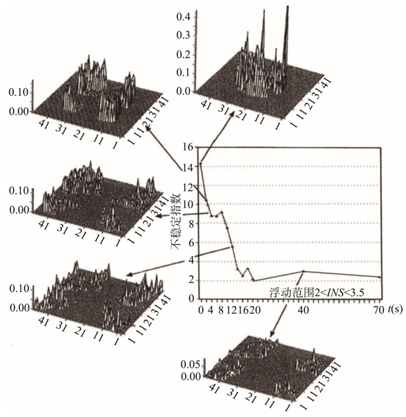
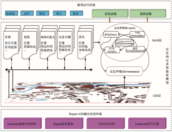
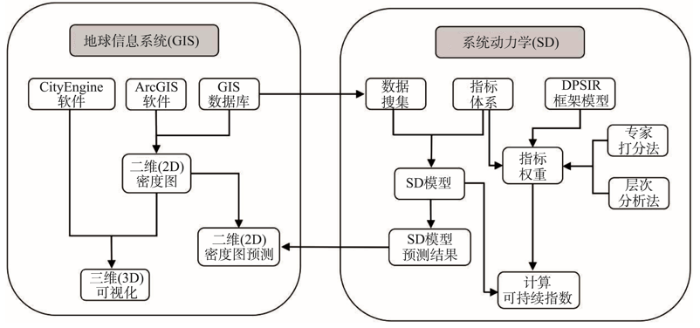