2016 , 18 (2): 272-281 https://doi.org/10.3724/SP.J.1047.2016.00272
宗鑫 , 王心源, 刘传胜
ZONG Xin, WANG Xinyuan, LIU Chuansheng
通讯作者:
收稿日期: 2015-07-22
修回日期: 2015-09-24
网络出版日期: 2016-02-10
版权声明: 2016 《地球信息科学学报》编辑部 《地球信息科学学报》编辑部 所有
基金资助:
作者简介:
作者简介:宗 鑫(1991-),男,硕士生,研究方向为探地雷达理论及其在考古探查中的应用。E-mail:zongxin@radi.ac.cn
展开
摘要
近年来,探地雷达被越来越多地应用于考古探查中。由于反演多解性问题的存在,雷达图像上的异常既可能是考古目标引起的,也可能是由于地下环境介质的不连续性引起的,所以探究不同类型的考古遗存在探地雷达图像上的典型异常响应,有助于准确识别雷达图像上的“真”异常,剔除一些“假”异常。首先,本文基于西北干旱-半干旱区文物埋藏环境,在河北省怀来县遥感综合试验站试验区设计实施了地下目标体探地雷达探测实验,分析了不同材质的小尺度目标体及夯土结构在探地雷达图像上的响应特征;然后,进一步将探地雷达应用于悬泉置遗址地下城墙基址的探测,对城墙在雷达图像上的响应特征进行了分析。实践表明,探地雷达技术在埋藏浅、小尺度、物性差异不大的考古探查中具有很好的效果,得到并解释了点状、线状、面状等不同考古目标体在探地雷达图像上的响应规律。
关键词:
Abstract
Ground Penetrating Radar(GPR) has been more and more widely used in archaeological investigations, because it can be a non-destructive, cost-effective way to locate buried structures in archaeological studies. Compared with the conventional geophysical tools used in the shallow explorations, the electromagnetic method, ground-penetrating radar (GPR), is more economical and is capable to produce large amounts of continuous, high resolution subsurface data. GPR canextend the exploration range of remote sensing (RS) to subsurface. However, because of the non-uniqueness of inversion, an anomaly could be raised by the archaeological interest or the inhomogeneity of underground matrixes, therefore studying the typical anomalies of diferent archaeological targets on GPR images is helpful to distinguish the “true” anamolies from the “fake” anamolies. Furthemore, some experiences and references could be provided. The following experiments have been carried out: firstly, in order to analysize how the small targets of different materials and rammed earth will raise anomalies on the GPR maps, GPR was emploied to detect five pre-buried targets that are equivalent to the archaeological interest and a beacon tower in a integrated experiment station of remote sensing. The first experiment of GPR prospection was designed to simulate the buried-enviorment of the archaeological structure in the northwest region of China whose climate is predominantly arid. Secondly, the authors applied GPR in detecting the residual city walls of Xuanquanzhi ruins, then analysized the response features of the walls, and found that the detecting results well fitted the excavation. The engineering practice indicates that the ground penetrating radar technology is successful and effective in invetigating the archaeological remains which are of small scale, buried shallowly and very analogical with the matrixes in electromagnetic nature. The response models of different archaeological targets, which are respectively considered as the point, line and surface shape, have been proposed and explained according to the principle of rectilinear propagation of electromagnetic wave.
Keywords:
目前,卫星遥感、航空遥感、GPS等越来越多的空间技术被应用于考古探查[1-4],而且文化遗产正逐步形成对“空-天-地”一体化的多源集成观测,为文化遗产的探查提供了强有力的技术支持。然而,这些空间观测技术主要解决地表、次地表文化遗产的探测问题,对地下文化遗产的探测能力比较有限[5]。探地雷达(Ground Penetrating Radar,GPR)是用于确定地下介质电性异常分布的电磁技术,它具有频带宽(1MHz-1GHz)、短脉冲、高采样的特点,能实现对地下文化遗产的准确无损探测,探地雷达技术可将遥感的探测“触角”延伸到地下,从而形成文化遗产从宏观-中观-微观、从地表-次地表-地下的空间观测体系。
自从1975年Vicker[6]等首次将探地雷达应用于考古探测以来,世界各地不断涌现出探地雷达考古的案例[7-10]。近几年,国内也开始越来越多地利用探地雷达进行考古探测[11-17]。然而,由于零空间的存在和数据的有限性,包括探地雷达在内的地球 物理反演都不存在唯一解,雷达图像异常既可能是地下介质的不均匀性引起的,也可能是考古遗存造成[18]。因此,确定不同类型的地下目标体在探地雷达上的典型异常响应有利于准确识别探地雷达图像上的“真”异常,剔除一些“假”异常,再结合相关的考古信息和钻探资料,才能给出更加科学合理的结果。
本文通过探地雷达物理模拟实验以及实地的考古探测,分析干旱-半干旱环境下不同类型的地下目标体在探地雷达图像上的典型异常反应特征,并且进一步采用时间切片三维显示技术来刻画地下考古遗存。其步骤为:(1)室外模拟实验。在中国科学院河北省怀来县遥感综合试验站的试验场内,预先埋设不同类型的物体,模拟西北地区干旱-半干旱地下埋藏环境的考古遗存,然后用探地雷达进行目标探测,通过波形分析和时间切片技术,分析不同类型考古遗存的反射异常特征,检验其探测效果,为探地雷达在西北地区环境下的考古应用做准备;(2)野外真实检验。选取敦煌市悬泉置遗址作为实验区,利用探地雷达检测悬泉置的地下城墙基址。2次探测实践均取得了理想效果。
传统的田野考古要依靠肉眼观察土层的土质、土色及其包含物来描述考古堆积物和划分文化层,如夯土、路土、灰土等,考古学家的经验至关重要。但是,由于经过长时间地球物理化学作用,探测目标与周围环境的差异有时很难用肉眼分辨出来,需要借助地球物理和遥感等科学方法来分辨这种不同。地球物理和遥感探测所利用的物理性质主要包括电性、磁性、波阻抗、传热性、密度等,探地雷达主要反映的是地层的介电常数和导电率等电性差异,这主要由物质的矿物成份、颗粒大小、渗透性和含水饱和度等决定。所以,对考古遗存及其周围环境的物理性质、地质条件掌握得越多,就越能减少地球物理勘探所带来的多解性,越能准确地探测出地下考古遗存。
考古遗存的如下特征决定了探地雷达在考古勘探中具有独特的优势[18]:(1)埋藏深度较浅。地下考古遗存的埋深大多不会超过10.0 m,一般在2.0~5.0 m之间,探地雷达的最大探测深度可在几米到十几米之间浮动,其最有效探测深度正好与考古遗存的深度分布基本一致。(2)几何尺度小。较小的器物如铜钱、瓷碗等都在亚米级甚至厘米级尺度范围内,即使城墙、墓葬等较大的遗存其宽度也只有数米,探地雷达的几何分辨率根据其天线的中心频率可以达到厘米级,能够满足考古应用需求。(3)有些年代久远的考古遗存与周围环境的物性差异不大。例如,在中国考古遗存中常见的夯土结构,经过千百年的物理化学作用,其物理性质跟周围沉积土层的差异很小。然而实测表明即使在复杂的地质条件下,探地雷达也可分辨出保存较好的夯土结构,本文为探地雷达考古应用的一个典型案例。
探测区域为中国科学院遥感与数字地球研究所河北省怀来县试验站内的试验场,分2个测区。探测区域1为模拟的地下考古遗存埋藏区,位于试验场东部的一块实验农田内。该区属于半干旱季风气候,实验时间选择冬季,天气干燥,土壤含水量低;土壤类型属于粘质壤土,土质偏粘、稍紧、较为致密,由于其性质跟粘土非常相似,且含水量较低,故取非饱和粘土的电磁波传播速度(0.09~0.12 m/ns)[19]作为雷达波速;周边是大片农田,十分空旷,没有电线、交通工具等造成的电磁干扰;没有种植农作物,地形非常平坦,探地雷达容易行进。探测区域2为试验站内一处明代的烽火台遗址,该烽火台遗址是由夯土构筑,台基为方形,烽燧为圆筒形。为了检验探地雷达对夯土层的探测效果,围绕烽燧,在台基上布置了一条闭合测线。
在探测区域1的农田内挖掘一道长1.8 m、宽1.0 m、深1.8 m的坑道,坑道呈南北向延伸,用于掩埋探测目标物。在1.8 m深的坑道底,用红砖搭建了一处构筑物,另外旁边30 cm处放置了一根木棒。然后往坑道内回填原生土,当坑道深至1.0 m时,再将铁盒、瓷瓶、瓷碗以50 cm的间隔放置坑道中,最后将坑道填平。西北地区(如新疆、甘肃等)有许多被风沙掩埋的历史时期的古城遗址,其中有大量的木质、金属、陶瓷等生活用品遗物,以及土质乃至砖石建筑(基础),所以实验中选择木棒、铁盒、瓷瓶、瓷碗、红砖等模拟埋藏遗物。同时,这些目标体具有尺度小、与周围环境物性差异不大、埋藏浅等特征,相比于其他物探手段,探地雷达更有优势。目标体的尺寸、埋深见表1,在坑道中的分布情况见图1。
表1 目标体的尺寸和埋深
Tab. 1 The sizes and buried depths of the targets
| 红砖构筑物 | 木棒 | 铁盒 | 瓷瓶 | 瓷碗 | |
|---|---|---|---|---|---|
| 尺寸/cm | 长:49.2 | 长:32.1 | 长:8.9 | 瓶口直径:3.2 | 高:4.1 |
| 宽:21.4 | 宽:7.2 | 宽:5.0 | 瓶身最大直径:9.2 | 碗口直径:9.8 | |
| 高:16.4 | 高:4.1 | 高:15.8 | |||
| 埋深/m | 1.8 | 1.8 | 1.0 | 1.0 | 1.0 |
探地雷达天线中心频率的选择主要与探测深度、空间分辨率有关。天线频率越高,分辨率越高,但探测深度会下降;反之亦然。故确定天线频率需综合考虑分辨率和探测深度,其中,天线中心频率与需要的空间分辨率及土壤的相对介电常数满足式(1)的关系。
式中:
表2 探测深度与天线中心频率对应简表
Tab. 2 Suitable central frequency of GPR for various depths of interest
| 深度/m | 中心频率/MHz |
|---|---|
| 0.5 | 1000 |
| 1.0 | 500 |
| 2.0 | 200 |
| 7.0 | 100 |
| 10.0 | 50 |
| 30.0 | 25 |
| 50.0 | 10 |
探测区域1需埋藏目标物的尺度为亚米级,所以空间分辨率x设定为0.1 m。由于本实验主要是针对西北地区干燥沙土埋葬环境,干燥沙土的平均相对介电常数为4[20]。根据式(1)计算可得
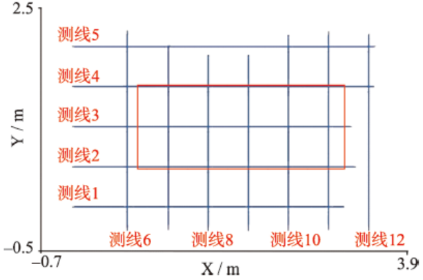
探测区域1使用的是意大利生产的RIS-K2探地雷达。根据表2和式(1)得到的计算结果,375~500 MHz的天线最适宜,但为了获得更高的分辨率以及实验条件的限制,最后选用了600 MHz的天线。在坑道区域内布置了网状测线(图2中红线为坑道的位置,蓝线为测线的位置,并依次编号),每条测线的间隔为0.5 m,共布置了12条测线。其中,南北向的测线有5条,长度在3.1~3.5 m之间;东西向的测线有7条,长度在2.1~2.5 m之间。每条南北向测线起点位置的X坐标均相同,每条东西向测线起点位置的Y坐标均相同,这样便于不同测线之间做比对分析。
在烽火台的台基上围绕烽燧布设了一条闭合的探地雷达测线,烽燧遗址的探测采用的是俄罗斯生产的OKO-2(E)型探地雷达,预估夯土层的埋深不会超过10.0 m,综合考虑分辨率和探测深度,天线中心频率选择100 MHz,测线长度为12.1 m。
进行现场数据采集时,在野外做好详细的相关记录,数据采集完毕后,在野外初步进行核查,防止数据出现缺失,确保数据完整。RIS-K2型探地雷达数据后处理采用与之配套的GresWin 2处理分析软件,OKO-2(E)型探地雷达则采用与之配套的GeoScan 32数据后处理软件。
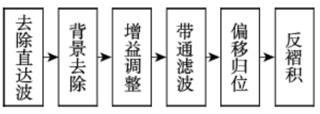
选择数据处理方法的基本原则:在保证去除干扰,突出有效目标反射的前提下,尽量提高效率,处理方法组合简单有效,不片面追求复杂的处理方法和过程。选择处理方法组合及处理参数时,结合以往处理经验,反复进行尝试、比对,以达到最佳处理效果。具体的处理流程见图3。背景去除时,最大深度应比目标体深度稍深一些,故测区1的最大深度设置为2.0 m,测区2的最大深度设置为8.0 m;增益调整采用AGC增益,2个测区的增益窗宽均取1.0,增益最大值均为500[21];带通滤波的下限截止频率设置为天线频率的一半,上限截止频率设置为天线频率的2倍,故600 MHz天线的截止频率为300~1200 MHz,100 MHz天线的截止频率为50~200 MHz;偏移归位采用克希霍夫积分偏移,波速取0.11 m/ns[22];反褶积采用预测反褶积法[20]。
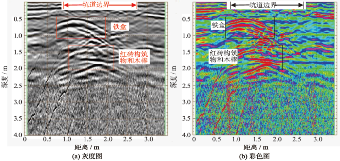
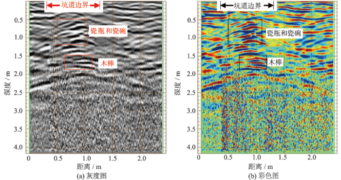
图4是测线3经过处理后的雷达探测图像,其中图4(a)是灰度图,图4(b)是彩色图,测线3大致为坑道的长轴,长度为3.5 m。由图4(b)可看出,在测线方向0~0.9 m和2.8~3.5 m之间,深度0~0.5 m范围内,反射同相轴呈现水平、成层分布,这部分对应于坑道外侧区域,由于坑道外侧的土没有被人工挖掘过,较密实,保持了原来的层状分布,在探地雷达图像上呈现出这种水平层状纹理;相反,在0.9~2.8 m之间,图像纹理杂乱,没有明显的水平层状反射同相轴,这是由于此处的土被挖掘过,水平层状结构被破坏,较疏松,这部分对应于坑道区域,其长度与坑道的实际长度相符。
图4(a)中红色矩形框和图4(b)中的黑色矩形所框出的区域是一致的,这2个区域均存在明显的反射异常,而且反射异常均呈现双曲线特征。结合掩埋时5个目标体在坑道中的分布位置,推断深度在1.0 m左右,X坐标在1.0~1.7 m范围的反射异常由铁盒引起;深度在1.8 m左右,X坐标在1.3~2.3 m范围内的反射异常由红砖构筑物和木棒共同引起。相比而言,电磁波对铁盒的反射能量更强,这是由于金属的波阻抗很小,反射系数接近于1,几乎“全反射”,电磁波能量几乎全被反射了,这一性质非常有利于地下金属器物的探测。
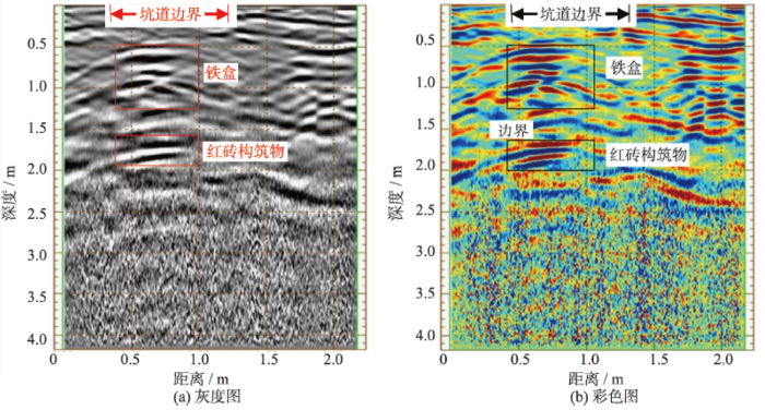
图5是测线8经过处理后的雷达探测图像,大致从铁盒上方通过,测线长度为2.2 m。由图5可见,在测线方向0.3 m和1.3 m处有较明显的坑道边界,这与坑道的实际宽度相符。在测线0.4~0.8 m之间,深度1.0 m左右存在强烈的双曲线异常,推断此处应为铁盒;在大致相同测线范围内,深度1.8 m左右也存在较明显的双曲线异常,此处应是红砖构筑物。
图6是测线10经过处理后的探地雷达图像,大致经过瓷瓶和瓷碗的中间,测线长度为2.5 m。如测线8一样,在测线方向0.4~1.4 m为坑道范围,宽度与坑道实际宽度相符。在测线0.6~1.2 m之间,深度1.0 m左右有明显的双曲线反射异常,推断应是瓷瓶和瓷碗造成的;在测线0.8~1.2 m之间,深度1.8 m左右也存在双曲线异常,应是木棒的反射信号。在测线3的雷达图像(图4)上,瓷瓶和瓷碗没有明显的反射异常,木棒和红砖构筑物的反射异常也交叉在一起表现为一个整体异常反应,而在测线10的雷达图像上瓷瓶和瓷碗、木棒均有明显异常。分析原因,这可能是瓷瓶和瓷碗在测线3上的反射信号受到铁盒强反射信号的干扰而只有微弱的显示,而测线10排除了铁盒的干扰,所以瓷瓶和瓷碗的信号有了较强的显示。
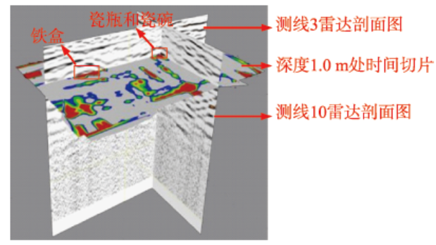
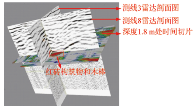
将每条测线的雷达剖面图在深度方向上以0.5 m(大约一个波长)的窗口进行平均,在沿测线方向同样以0.5 m(测线间距)的窗口进行平均,然后在探测区域内对数据体进行网格化重采样,网格单元大小为0.1 m,重采样后的数据体在不同时间截面(深度截面)的图像即为时间切片。图7是测线3、测线10的雷达剖面图像和深度1.0 m处时间切片的组合显示,从图上可以看到,铁盒、瓷瓶和瓷碗在雷达剖面图像上的双曲线异常与深度1.0 m处的时间切片上的反射异常在空间上吻合;图8是测线3、测线8雷达剖面图像与深度1.8 m处时间切片的组合显示,同样,红砖构筑物和木棒在雷达剖面图像上的双曲线异常与深度1.8 m处的时间切片上的反射异常在空间上也是吻合的。
图7 坑道测线3、测线10雷达剖面图像和深度1.0 m处时间切片组合显示
Fig. 7 The profiles of line 3 and line 10 and the time slice of 1.0m for the tunnel
图8 坑道测线3、测线8雷达剖面图像与深度1.8 m处时间切片组合显示
Fig. 8 The profiles of line 3 and line 8 and the time slice of 2.0 m for the tunnel
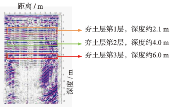
夯土是中国典型的考古遗存,早期的城墙、建筑、墓葬等很多都是由夯土筑成。图9为探测区域2烽火台处的闭合探地雷达测线的剖面图,由图可见,在深度2.0~6.3 m范围内,反射同相轴呈水平、层状分布,这是由于构筑夯土是一层一层地进行夯实,所以,在上下夯土层之间的界面处电性会发生变化,探地雷达图像上则表现为水平层状的反射同相轴。
通过以上的实验分析可以看到,探地雷达能有效、准确地探测出埋藏在地下的目标物。从反射能量上看,金属类器物的反射波能量较强,可能会对周围距离较近物体的反射波造成一定干扰,使周围物体在雷达图像上的显示被削弱;从反射异常的形态上看,如果目标体相对于探地雷达装置可看成点状体,那么其典型的反射异常形态呈双曲线形;保存较好的夯土层则可看作为面状体,在探地雷达图像上经常表现为水平、层状的反射异常。
另外,将雷达剖面图像与时间切片组合显示,不仅能展示出地下目标体随深度的变化规律及其相互之间的空间位置关系,而且还能将雷达剖面图像上的物探解释与时间切片上的物探解释相互对比、相互印证,能提高解释结果的准确性和可靠性。
敦煌市位于河西走廊的西端,是古代中国向西通往西域、中亚和欧洲的丝绸之路的起点。其境内分布着大量的古文化遗址,地下文化蕴藏极其丰富,悬泉置就是其中的代表之一。由于敦煌市是一片“戈壁绿洲”,其周边分布着广大的戈壁和沙漠,很多古遗址就被埋没在这些戈壁和沙漠之中。传统的野外考古探测方法,不仅需耗费大量的人力、物力和财力,且效率较低,致使不少地下古遗址至今还没有被摸清。为了更快速、准确、经济地探明地下古遗址的位置,掌握其地下分布特征,从而对遗址实施科学有效的保护,需将传统的野外考古手段与其他先进的科学技术手段相结合。
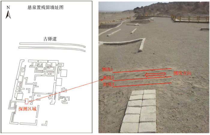
悬泉置遗址位于甘肃省敦煌市东部64 km的戈壁深处,遗址总面积2.25万 m2,是一座方形小城,门朝东,四周为高大的院墙,边长50 m,城墙是用土坯垒砌而成的土坯墙,大部分城墙都保留了下来。古代悬泉置是丝绸之路上重要的邮驿机构,是目前唯一被发现的中国汉代驿站类遗址,具有极高的历史和考古价值。
悬泉置区域气候干燥,回填土的土质属于干燥、疏松多孔的戈壁砾土,土质较为均一,而且含水量少,有利于电磁波的传播,干扰信号也比较少,地形平坦,有利于探地雷达作业。
悬泉置探测区域(图10)的地下埋藏着一段城墙残基,该城墙残基是西南角角楼北侧土坯城墙的一段,为了检验探地雷达对该段墙基的探测效果,沿垂直墙基方向布置了3条测线,测线间的间距为0.5 m,大致沿南北向,进行数据采集时,当雷达经过城墙大致位置的时候,就在雷达图像上做出相应的标记,以方便快速定位反射异常,同时便于3条测线之间相互比对。
本次探测所采用的是意大利生产的RIS-K2型的探地雷达。从当地文物管理部门得知,悬泉置回填土有1.0~2.0 m,且城墙尺度较大,不需要太高的分辨率,故根据表2参数范围,天线中心频率选择200 MHz。数据后处理软件也是与RIS-K2探地雷达相配套的GresWin 2处理分析软件,数据处理所采用的方法组合与图3所示的处理流程相同,只是对部分处理参数做了相应的改变,其中背景去除的最大深度设置为3.0 m,带通滤波的上下限截止频率为100~400 MHz,其他参数不变。
图10 悬泉置探测区域以及测线布设图
Fig. 10 The survey area and location map of the GPR profiles for Xuanquanzhi ruins
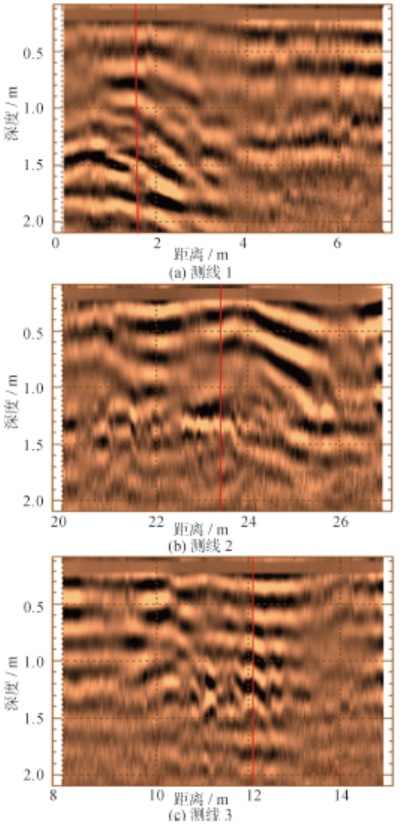
图11是悬泉置探测区域3条测线的雷达剖面图,每幅图上的红色标线是在探地雷达经过墙基大致位置时所做的标记,由图可见,3条测线在标线位置处均出现了明显异常,推断是地下残留的城墙造成的,该城墙覆盖深度在0.5 m左右,宽度在3.0~5.0 m之间。城墙相对于探地雷达可看作是一种线状体,其在不同测线上的异常呈现出了介于点状体和面状体的过渡形态,在测线1和测线2上异常显示为双曲线形态,而在测线3上呈现出的是一种整体性的层状异常形态,这可能是由于此处的城墙损毁比较严重,剥落下来的土掺杂在周围土层中,使该部分城墙与周围土层的区别变小,从而该处的异常信号仅表现为一种整体性的异常。
图12 探地雷达探测地下考古遗存示意图
Fig. 12 The schematic diagram of detecting the archaeological interest using GPR
探地雷达通过发射天线向地下发射电磁波,电磁波经过地下文物或者文化层反射后被接收天线所接受,如图12(a)所示。假设地下考古遗存的反射点深度为h,天线记录点与反射点的距离为d,天线记录点与反射点在地面的投影距离为x,根据电磁波的直线传播原理和几何关系可得式(2)。
经过变换可得:
式(3)是一个虚轴和实轴相等的双曲线方程,是地下文物的探地雷达反射特征公式,即某反射点在一系列测点
根据地下考古遗存相对于探地雷达天线波束宽度的大小,可以将其分别看做点状、线状、面状目标体。如果目标体的几何尺度远小于天线的波束宽度,则可将其看做点状体(如本文中的金属盒、陶瓷瓶),从式(3)可知,其典型异常反应为双曲线形;如果目标体的几何尺度远大于天线的波束宽度,则可以将其视为面状体(如本文中烽火台的台基),此时式(3)中的
为了研究考古目标体在探地雷达图像上的响应特征,从而为区分考古目标体和地下介质不连续性引起的异常响应提供依据,本文设计实施了考古文物的模拟探测试验,并且实地探测了古烽燧和古遗址地下城墙。在对探测结果进行分析的基础上,得到了点状、线状、面状考古目标体的响应特征,并从电磁波传播规律出发,推导了考古目标的探地雷达反射特征公式,从而解释了不同类型目标体的反射特征机理。但是,目前探地雷达更多的是对地下文物进行定位、定深,还无法分辨出地下文物的类别,需结合探测区域相关的考古以及钻探资料,才能对地下文物的类别给出准确的结论。同时,需要发展更有效的技术方法,从雷达图像上提取出更多关于目标体的信息,利用目前最有效的探地雷达属性技术,实现探地雷达的定量化。
致谢:感谢秦艳芳博士对于探地雷达实验给予的指导与支持,甘肃考古研究所张俊民研究员对于悬泉置雷达探测验证给予支持与帮助,北京博泰克仪器设备有限公司的李庆春工程师以及欧克思仪器(北京)有限公司的张军刚工程师给予了设备和技术上的支持,在此一并表示衷心的感谢!
The authors have declared that no competing interests exist.
| [1] |
Aerial survey for archaeology [J].https://doi.org/10.1046/j.0031-868X.2003.00023.x URL [本文引用: 1] 摘要
ABSTRACT Aerial photography for archaeology has been developing its approaches and techniques over the past 100 years so that it now integrates the results of reconnaissance with extensive interpretative and analytical surveys. This paper introduces the philosophy and approach of the English Heritage (EH) Aerial Survey team, covering aerial reconnaissance and the National Mapping Programme (NMP), as well as the potential developments and opportunities in Europe. In the 1980s there was a debate over the nature of the evidence derived from aerial photographs, especially how to describe archaeological features. As part of NMP a classification and recording system has been devised which meets most of the users’ needs, be they national organisations, county archaeologists, commercial contractors or university-based researchers. The maps and records produced by NMP are used to further our understanding of the past human settlement in England, not only at the individual site level, but also in regional or landscape contexts. This paper provides an overview of the current progress of NMP and acts as an entrée for explaining the current research and recording of archaeological landscapes throughout Europe. Recent developments in Britain and Europe have provided the opportunity for a greater priority to be given to aerial survey and accelerating programmes of mapping. In Europe the ending of the cold war has allowed greater access to aerial photographs and the possibility of beginning new reconnaissance, as well as introducing new forms of remote sensing. All these developments have led to a transformation of our understanding of prehistoric, Roman and medieval archaeology.RésuméL'emploi des photographies aériennes pour l'archéologie s'est développé au cours des cent dernières années au point d'arriver maintenant à intégrer techniquement les résultats de la reconnaissance classique avec les relevés analytiques et interprétatifs concernant de grandes étendues. On aborde dans cet article la méthode et la philosophie de l’équipe de levé aérien du service du Patrimoine anglais, en y incluant la reconnaissance aérienne et le programme national de cartographie (NMP), ainsi que les possibilités et les occasions de développement en Europe. Il y a eu dans les années 1980 un débat sur la nature des témoignages apportés par les photographies aériennes, en particulier sur la façon de décrire les éléments archéologiques. On a pu concevoir, dans le cadre du NMP, un système d'enregistrement et de classification qui satisfait la plupart des besoins des usagers, qu'il s'agisse d'organismes nationaux, d'archéologues dans les comtés, de contractants commerciaux ou de chercheurs universitaires. L'emploi des enregistrements et des cartes établies par le NMP facilite notre compréhension des implantations humaines du passé en Angleterre, non seulement au niveau d'un site individuel, mais aussi dans leur contexte paysager ou régional. On fournit dans cet article un aperçu des progrès actuels du NMP et une clé permettant d'expliquer les recherches en cours en Europe et les saisies sur les paysages archéologiques. Les développements récents effectués en Angleterre comme en Europe ont permis d'accorder une priorité plus grande aux levés aériens et ont accéléré les programmes de cartographie. La fin de la guerre froide a ouvert en Europe un accès bien plus grand aux photographies aériennes et permet d'entreprendre de nouvelles reconnaissances et de recourir également à de nouvelles formes de télédétection. Tous ces développements nous ont amenéà modifier notre compréhension de l'archéologie pré-historique, romaine et médiévale.ZusammenfassungDie Luftbildphotographie für die Archäologie hat in den letzten einhundert Jahren ihre Ansätze und Techniken so weit fortentwickelt, dass sie heutzutage die Erkundungsergebnisse mit ausführlichen Interpretationen und analytischen Untersuchungen ergänzt. Dieser Beitrag führt in die Philosophie und die Vorgehensweise der Arbeitsgruppe für Luftbildvermessung des staatlichen Denkmalschutzes ein. Es werden die Erkundung aus der Luft und das Nationale Kartierprogramm (NMP), sowie weitere potentielle Entwicklungen und Möglichkeiten in Europa vorgestellt. In den 80er Jahren des 20. Jahrhunderts gab es eine Debatte über die Art der Nachweise, die aus Luftbildern gewonnen werden können, insbesondere darüber, wie archäologische Merkmale beschrieben werden können. Als Teil des nationalen Kartierprogramms wurde ein Klassifizierungs- und Erfassungssystem ausgedacht, das die meisten Nutzeranforderungen erfüllt, seien es nationale Organisationen, Archäologen auf Kreisebene, kommerzielle Anbieter oder universitäre Forscher. Die Karten und Dokumente, die durch NMP produziert werden, werden zur Vertiefung unseres Wissens über frühere Besiedelung in England, nicht nur an individuellen Orten, sondern auch im regionalen oder Landschaftskontext verwendet. Dieser Beitrag gibt einen Überblick über den aktuellen Fortschritt von NMP und führt erklärend in die aktuelle Forschung und Erfassung archäologischer Landschaften in Europa ein. Jüngste Entwicklungen in Großbritannien und Europa haben die Möglichkeit eröffnet, dass die Luftbildvermessung mit höherer Priorität zur Beschleunigung von kartographischen Programmen eingesetzt wird. Durch das Ende des Kalten Krieges in Europa ist sowohl der Zugang zu Luftbildern erweitert worden, als auch die Möglichkeiten geschaffen worden, neue Erkundungen durchzuführen und neuen Formen der Fernerkundung anzuwenden. All diese Entwicklungen haben dazu beigetragen, unser Verständnis der prähistorischen, römischen und mittelalterlichen Geschichte zu verändern.
|
| [2] |
Detection of exposed and subsurface archaeological remains using multi-sensor remote sensing [J].https://doi.org/10.1016/j.jas.2006.06.018 URL Magsci 摘要
Multi-sensor airborne remote sensing has been applied to the Itanos area of eastern Crete to assess its potential for locating exposed and known buried archaeological remains, and to delineate subsurface remains beyond the current limits of ground geophysical data in order to permit future targeted geophysical surveys and archaeological excavations. A range of processing techniques (e.g., Reed鈥揦iaoli anomaly detection) have been applied to the CASI, ATM and lidar data in order to detect anomalies based on the premise that buried remains are likely to alter the physical and chemical characteristics of the soil compared with those of the surroundings due to variations in soil depth and drainage. Through a combination of CASI, ATM and lidar data, surface remains have been classified and mapped effectively using an object-oriented approach. The detection of subsurface remains is more problematic; however, the thermal data is most promising in this respect. The value of capturing multi- or hyperspectral data at a high spatial resolution has been demonstrated as well as the additional benefits of combining these with airborne lidar.
|
| [3] |
Mapping ancient chinampa landscapes in the Basin of Mexico: A remote sensing and GIS approach [J].https://doi.org/10.1016/j.jas.2012.03.001 URL 摘要
This paper uses remote sensing data to document a raised field, chinampa system adjacent to the Postclassic kingdom of Xaltocan in the northern Basin of Mexico. Various forms of landscape information; historic records and maps as well as remote sensing; are considered to understand the chinampa system. The remote sensing data examined include 1950s aerial photographs, Landsat 7 data, and Quickbird VHR, multi-spectral imagery. This article evaluates the utility of each of these forms of data to identify buried chinampa features and integrates them in a GIS to produce a map of Xaltocan's chinampa landscape. Canals of various sizes and hydrological positions comprised the chinampas and integrated the system together. Occupying at least 1500–2000ha, Xaltocan's chinampa system represents the largest pre-Aztec, chinampa system in the Basin of Mexico.
|
| [4] |
Integrated RS, GIS and GPS approaches to archaeological prospecting in the Hexi Corridor, NW China: A case study of the royal road to ancient Dunhuang [J].https://doi.org/10.1016/j.jas.2014.07.009 URL [本文引用: 1] 摘要
According to historic records, the wasteland northeast of modern Dunhuang oasis contains remarkable, undiscovered monuments of medieval courier stations. In this study, statistical analysis of historic records and census data, image processing and interpretation of satellite remote sensing images, GIS analysis, and field surveys were carried out to contribute to the discovery of courier stations and the reconstruction of the medieval royal road system from Guazhou to Shazhou. Firstly, in order to obtain the existence regions of courier stations, historic records and census data were abstracted and digitized, for generating preliminary regions of interest by using GIS tools. Secondly, dried river channels and traces of the Great Wall were extracted from the remote sensing images, and GIS buffer and overlay analyses were applied to the creation of prospective sub-areas. Thirdly, prospective sub-areas were mapped from very high resolution WorldView-2 images, and suspected sites were found based on the human-computer interactive interpretation. Fourthly, suspected sites were investigated on the GPS-based archaeological survey, and were confirmed as two courier stations based on the remains of Han-Tang period observed at sites' surface. Lastly, the royal road to ancient Dunhuang, one of the most important sections of the royal road system in the Hexi Corridor, was discussed and reconstructed with the combined application of remote sensing imagery and ground-truthing.
|
| [5] |
空间观测技术集成与数字文化遗产研究[A].香山科学会议第487次学术讨论会筹备组.文化遗产空间观测与认知 [C]. |
| [6] |
A communication on archaeological radar experiment at Chaco Canyon [J]. |
| [7] |
McGill J W. Archaeology studies in southern Arizona using ground penetrating radar [J].https://doi.org/10.1016/0926-9851(95)90042-X URL [本文引用: 1] 摘要
Conventional ground penetrating radar (GPR) surveys typically have a maximum depth of penetration ofto 1 m in the basin-fill sediments of the southwestern United States. Although this depth of penetration is too limited for many engineering and environmental surveys, it is often suitable for archaeological investigations in this region. We have found a center frequency of 500 MHz to be optimum. Radar signals having a center frequency of about 80 MHz produce records with much lower resolution and only slightly greater maximum depth of penetration.Successful GPR surveys have imaged buried plaster and adobe walls, roasting pits, canals, trash pits, plastered floors, and artifacts such as pot sherds and knives. We have found that GPR is a valuable tool for archaeological studies in this area. GPR can provide some of the detailed survey information that has been provided in the past by extensive excavation, but without the high cost of excavation, without the dangers of vandalism when artifacts are exposed, and without disturbing sensitive areas.
|
| [8] |
McFarland D P, Hackenberger S. Three-dimensional GPR study of a prehistoric site in Barbados, West Indies [J]. |
| [9] |
Archaeological objects in loesses recognized by GPR research at the site Karmanowice, Poland [J].https://doi.org/10.2478/s11600-007-0024-4 URL 摘要
The aim of the research was to examine subsurface soil layers with the use of the Ground Penetrating Radar (GPR) method. Neolithic archaeological post in Karmanowice was examined. On the basis of earlier geophysical researches and archaeological premises, eight measurement profiles had been chosen. Ground Penetrating Radar system with antenna of 500 MHz frequency was applied. The measurements were made with 30 and 60 ns time windows. The results were shown as the GPR sections. The analysis of the obtained results allowed us to outline anomalies connected with the appearance of archaeological objects in subsurface soil layers. The border between the anthropogenically changed upper layer and undisturbed loess was established, and the sections of slope wash layers were designated. Anomalies were confirmed by digging and test drillings. Additionally, 2D resistivity imaging method was used for verification of specific anthropogenic anomalies.
|
| [10] |
Ground-penetrating radar investigations at Marj Rabba, a Chalcolithic site in the lower Galilee of Israel [J].https://doi.org/10.1016/j.jas.2014.03.013 URL [本文引用: 1] 摘要
The Chalcolithic site of Marj Rabba, in the lower Galilee of Israel, features shallow limestone structures situated in a terra rossa matrix. Calcareous substrates such as terra rossa, common throughout the region, are often not considered amenable to ground-penetrating radar (GPR) studies due to strong attenuation, particularly within the relatively high frequency range most often used in archaeological GPR surveys. Energy loss due to scattering from small embedded stones also exacerbates attenuation at this particular site in addition to obscuring detected archaeological features, thereby complicating interpretation. Because features are fairly shallow (upper 1.5m) and contrast well with the soil, however, GPR was successful in spite of poor substrate quality. The selection of a somewhat lower antenna frequency (250MHz) than is often recommended for archaeology, played a role in the success of the work. The end result expands the known spatial extent of the site by five-fold, increasing our knowledge of architectural and village plans for a time period which is poorly understood in this region. The settlement scale and complexity shown by these new results indicates that Chalcolithic villages are not only present in the Galilee but are as extensive and architecturally sophisticated as contemporaneous settlements in other regions. In combination with excavation results, the structures detected with GPR at Marj Rabba provide the largest plan of an early Chalcolithic settlement in the Galilee.
|
| [11] |
基于探地雷达的古墓遗址探测及数据后处理方法 [J].https://doi.org/10.3321/j.issn:1007-4619.2001.04.013 URL Magsci [本文引用: 1] 摘要
探地雷达用于地下考古目标和地下遗址分布的确定,为探地遥感应用 开辟了广泛的应用前景.以浙江、绍兴印山大墓为地下探测特定目标,针对长江下游地区地下水位高、土壤潮湿使电磁波被地下水大量吸收而无法很好地深入地下, 目标回波信号幅度小、信噪比低而影响探测结果,以冲击脉冲雷达和线性调频雷达两种方式对地下目标作用,以获取同一地下目标的各种电特征数据和地下目标同一 物理特征的不同电参量表示,提高接收信号的信噪比,增加探测深度.并用回波能量相关方法辨别地下古代遗址的外形轮廓以确定目标位置.选择不同天线位置,对 地下目标的反射特性参数做聚类处理.利用图像处理方法,使地下古墓廓线三维反演成像,并使位置误差最小.为古墓的无损探测提供了一种可行的方法.
GPR for ancient relics sounding and a method of GPR’s data post processing [J].https://doi.org/10.3321/j.issn:1007-4619.2001.04.013 URL Magsci [本文引用: 1] 摘要
探地雷达用于地下考古目标和地下遗址分布的确定,为探地遥感应用 开辟了广泛的应用前景.以浙江、绍兴印山大墓为地下探测特定目标,针对长江下游地区地下水位高、土壤潮湿使电磁波被地下水大量吸收而无法很好地深入地下, 目标回波信号幅度小、信噪比低而影响探测结果,以冲击脉冲雷达和线性调频雷达两种方式对地下目标作用,以获取同一地下目标的各种电特征数据和地下目标同一 物理特征的不同电参量表示,提高接收信号的信噪比,增加探测深度.并用回波能量相关方法辨别地下古代遗址的外形轮廓以确定目标位置.选择不同天线位置,对 地下目标的反射特性参数做聚类处理.利用图像处理方法,使地下古墓廓线三维反演成像,并使位置误差最小.为古墓的无损探测提供了一种可行的方法.
|
| [12] |
杭州雷峰塔遗址地下遥感考古研究 [J].https://doi.org/10.3969/j.issn.1560-8999.2002.02.021 URL 摘要
雷峰塔位于杭州西子国宾馆内,始建于公元972年,于1924年 倒塌,曾是著名的西湖十景之一--雷峰夕照.为了重现昔日的景观,浙江省政府、杭州市政府决定重建雷锋塔,为此需要对雷锋塔进行考古清理,包括地下部分的 清理.为了确定塔基是否存在地宫,我们利用雷达设备对该塔基进行了探测,明确了地宫的存在.而且,地质雷达探测成果资料非常准确:水平位置 1.0~2.8m,纵向深度1.3~2.6m处的雷达波异常反射,是由夯土层引起的.水平位置1.5~2.4m,纵向深度2.6m处的双曲线型拱起反射波 同相轴是地宫顶板(石板)引起的.据此亦明确了地宫的大致位置.现场开挖发现地宫大小(包括地宫周边砖墙)为0.9×0.9m,高0.5m,这与雷达图像 资料吻合.
On Leifeng Tower site in Hangzhou using underground remote sensing archaeology [J].https://doi.org/10.3969/j.issn.1560-8999.2002.02.021 URL 摘要
雷峰塔位于杭州西子国宾馆内,始建于公元972年,于1924年 倒塌,曾是著名的西湖十景之一--雷峰夕照.为了重现昔日的景观,浙江省政府、杭州市政府决定重建雷锋塔,为此需要对雷锋塔进行考古清理,包括地下部分的 清理.为了确定塔基是否存在地宫,我们利用雷达设备对该塔基进行了探测,明确了地宫的存在.而且,地质雷达探测成果资料非常准确:水平位置 1.0~2.8m,纵向深度1.3~2.6m处的雷达波异常反射,是由夯土层引起的.水平位置1.5~2.4m,纵向深度2.6m处的双曲线型拱起反射波 同相轴是地宫顶板(石板)引起的.据此亦明确了地宫的大致位置.现场开挖发现地宫大小(包括地宫周边砖墙)为0.9×0.9m,高0.5m,这与雷达图像 资料吻合.
|
| [13] |
探地雷达技术在云冈石窟维护中的应用 [J].
Application of GPR technology in the protection and maintenance of Yungang Grottoes [J].
|
| [14] |
探地雷达在金沙遗址考古探测中的应用研究 [J].https://doi.org/10.3969/j.issn.1001-3946.2008.06.015 URL Magsci 摘要
金沙遗址是四川地区继三星堆之后又一重大发现.介绍了探地雷达方法在金沙遗址地下文物和文物文化层探测中的应用,其研究成果与开挖验证结果相吻合,肯定了探地雷达方法在科学考古中的应用效果.
The application of ground penetrating radar to the archeological exploration of Jinsha Ruins [J].https://doi.org/10.3969/j.issn.1001-3946.2008.06.015 URL Magsci 摘要
金沙遗址是四川地区继三星堆之后又一重大发现.介绍了探地雷达方法在金沙遗址地下文物和文物文化层探测中的应用,其研究成果与开挖验证结果相吻合,肯定了探地雷达方法在科学考古中的应用效果.
|
| [15] |
邺城遗址探地雷达考古调查研究[A].中国地球物理学会,中国地球物理2012 [
GPR archaeological research at Ye City Site[A]. Chinese Geophysical Society, Chinese Geophysics 2012 [C].
|
| [16] |
应用探地雷达多属性叠合分析对北庭故城古建筑基址的勘查[A].中国地球物理学会.中国地球物理2012 [
GPR survey of architectural ruins using multi-attribute analysis in Bei-ting Ancient Castl[A]. Chinese Geophysical Society, Chinese Geophysics 2012 [C].
|
| [17] |
探地雷达探测技术在奉先寺保护工程中的应用 [J].https://doi.org/10.11720/wtyht.2014.4.33 URL Magsci [本文引用: 1] 摘要
为了查明龙门石窟奉先寺周边岩体裂隙、岩体破碎带分布以及奉先寺顶部覆盖层厚度,为奉先寺的渗水治理提供基础资料,将探地雷达无损检测技术应用于奉先寺保护工程。探测结果显示,奉先寺顶部岩体较完整,神仙洞与卢舍那大佛之间裂隙和破碎带较多,形成了交叉网络渗水通道;奉先寺顶部覆盖层呈凹形分布,厚度在1~2.2m之间,有利于雨水的贮存和滞留。此次工程实践表明,将探地雷达技术应用于奉先寺岩体裂隙和覆盖层厚度调查是可行的,探地雷达在岩土文物保护中有巨大的应用前景。
The application of ground penetrating radar technology to the protection engineering of Fengxian temple [J].https://doi.org/10.11720/wtyht.2014.4.33 URL Magsci [本文引用: 1] 摘要
为了查明龙门石窟奉先寺周边岩体裂隙、岩体破碎带分布以及奉先寺顶部覆盖层厚度,为奉先寺的渗水治理提供基础资料,将探地雷达无损检测技术应用于奉先寺保护工程。探测结果显示,奉先寺顶部岩体较完整,神仙洞与卢舍那大佛之间裂隙和破碎带较多,形成了交叉网络渗水通道;奉先寺顶部覆盖层呈凹形分布,厚度在1~2.2m之间,有利于雨水的贮存和滞留。此次工程实践表明,将探地雷达技术应用于奉先寺岩体裂隙和覆盖层厚度调查是可行的,探地雷达在岩土文物保护中有巨大的应用前景。
|
| [18] |
GPR技术在考古勘探中的应用研究 [J].https://doi.org/10.3969/j.issn.1004-2903.2000.01.005 URL Magsci [本文引用: 2] 摘要
地面航向雷达(GPR)是一种高分辨率浅层地球物理勘探仪器,它适用于考古勘探中目标体埋藏浅、尺度小、物性差异不大的特点。结合近几年实际应用实例,本文介绍了GPR技术及其对承础石、夯土城墙和早期墓葬等不同考古遗存的探测效果,并就考古勘探的地球物理特点对GPR的数据处理和解释进行了探讨。
The applications of ground-penetration radar in archaeological prospection [J].https://doi.org/10.3969/j.issn.1004-2903.2000.01.005 URL Magsci [本文引用: 2] 摘要
地面航向雷达(GPR)是一种高分辨率浅层地球物理勘探仪器,它适用于考古勘探中目标体埋藏浅、尺度小、物性差异不大的特点。结合近几年实际应用实例,本文介绍了GPR技术及其对承础石、夯土城墙和早期墓葬等不同考古遗存的探测效果,并就考古勘探的地球物理特点对GPR的数据处理和解释进行了探讨。
|
| [19] |
Applications of ground-penetrating radar (GPR) to sedimentological, geomorphological and geoarchaeological studies in coastal environments [J].https://doi.org/10.1144/GSL.SP.2000.175.01.12 URL [本文引用: 1] 摘要
Acquisition of high resolution data regarding the stratigraphy and internal structure of coastal sedimentary sequences is becoming increasingly important in many sedimentological, geomorphological and geoarchaeological studies. Such information is usually obtained from the logging of field exposures, shallow trenches and cores. However, ground-penetrating radar (GPR), a relatively new and rapidly developing non-invasive geophysical technique, may also aid such investigations in certain coastal settings, providing additional, complimentary and often unique data sets. The technique is based on the transmission, reflection and reception of high frequency electromagnetic (radar) waves, with reflections occurring in the subsurface due to the varying electrical properties of the sediments. Such reflections can occur due the presence of primary sedimentary structures, lithological/material changes or water content changes. Examples presented from the UK indicate that the technique can accurately delineate the stratigraphy and internal sedimentary structure of coastal barriers, spits and strandplains, both above and below a fresh groundwater table. Sand and/or gravel-dominated beach-dune systems on moderate to high wave energy, macrotidal coasts appear to provide optimum settings for GPR deployment. In addition, the technique also has the potential to locate, map and provide stratigraphic context for a wide range of archaeological features that are commonly found in such coastal environments.
|
| [20] |
Principle and application of ground penetrating radar (GPR) [M]. |
| [21] |
探地雷达数据处理方法及其应用 [J].
在现有探地雷达反射法剖面数据处理技术基础上,提出一个数据处理方法模式,包括数据编辑、常规滤波、时间增益、数字处理、图形处理、显示和解释等。主要以实例阐述了模式各阶段的作用及其相互关系,强调数据处理方法的组合方式应简洁至上,遵循地质解释的处理准则。
Ground penetrating radar data processing method and its application [J].
在现有探地雷达反射法剖面数据处理技术基础上,提出一个数据处理方法模式,包括数据编辑、常规滤波、时间增益、数字处理、图形处理、显示和解释等。主要以实例阐述了模式各阶段的作用及其相互关系,强调数据处理方法的组合方式应简洁至上,遵循地质解释的处理准则。
|
| [22] |
克希霍夫积分偏移法在探地雷达图象处理中的应用 [J].https://doi.org/10.1007/BF02677081 URL [本文引用: 1] 摘要
由于探地雷达(GPR)剖面与 反射地震剖面的相似性,用于处理反射地震剖面的偏移理论与方法,可以用于GPR图象的处理,文中介绍了克希霍夫(Kirchhoff)积分偏移法的基本原 理及其在GPR图象处理中的应用,对已知地电模型的GPR记录进行了偏移处理,并给出了对两条实测GPR记录作偏移处理的实例,总结了偏移方法处理GPR 图象的应用条件。
Application of Kirchhoff integral migration method to processing GPR image [J].https://doi.org/10.1007/BF02677081 URL [本文引用: 1] 摘要
由于探地雷达(GPR)剖面与 反射地震剖面的相似性,用于处理反射地震剖面的偏移理论与方法,可以用于GPR图象的处理,文中介绍了克希霍夫(Kirchhoff)积分偏移法的基本原 理及其在GPR图象处理中的应用,对已知地电模型的GPR记录进行了偏移处理,并给出了对两条实测GPR记录作偏移处理的实例,总结了偏移方法处理GPR 图象的应用条件。
|

/
| 〈 |
|
〉 |

